ISSUES AND CHALLENGES IN GEOMATICS EDUCATION
IN HARYANA STATE, INDIA
B. S. Chaudhary*
Department of Geophysics, Kurukshetra University, Kurukshetra-136119, Haryana, India- bschaudhary@kuk.ac.in
Commission VI, WG VI/4
KEY WORDS: Geomatics, Geosciences, Education, Issues, Challenges, HARSAC, Kurukshetra University, Haryana State, India.
ABSTRACT:
In Haryana, the beginning of Geomatics may be traced back to the establishment of Haryana State Remote Sensing Application Centre (HARSAC) now renamed as Haryana Space Application Centre at Hisar under the aegis of Department of Science and Technology, Govt. of Haryana with the active support from Department of Space, Govt. of India in 1986. Though, Gurgaon has developed as Geomatics hub housing many national and international collaborators but mostly involved in RS& GIS applications and rarely as a training centre. Looking to the needs of the trained manpower in Geomatics, PG diploma course in remote sensing and GIS was started by MDU, Rohtak in 2005 followed by CRM, Jat College Hisar in 2007. GJU, Hisar came up with M. Tech. degree in Geoinformatics in collaboration with HARSAC, Hisar two years before i.e. in 2009. MDU, Rohtak has also come up the M. Tech. programme in Geoinformatics this year. The Geo-sciences disciplines including the department of Geophysics, Geology, Geography and Environmental Sciences in different universities in Haryana are also having a compulsory paper on RS, GIS and GPS emphasizing more on the fundamentals and applications specifically in their specific domains. The Department of Geophysics, Kurukshetra University, Kurukshetra has also established Geoinformatics lab with funding from UGC to cater the training needs in this sector. The present paper discusses critical issues related to the present status, grey areas and future scenario of Geomatics education in Haryana.
1. INTRODUCTION
1.1 General
Geomatics as the term signifies encompasses the recent techniques of Remote Sensing (RS), Geographical Information Systems (GIS), Global Positioning System (GPS) and Information & Communication Technology (ICT). Remote Sensing as the term signifies refers to the science or art of gathering information about an object or phenomenon on the surface of the earth from a distance and essentially by using electromagnetic radiation. GIS is defined as an information system that is used to input, store, retrieve, manipulate, analyze and output geographically referenced data or geospatial data in order to support decision making for planning and management of various resources. The GPS helps in exact location and altitude information about the features present on the surface of the earth and for navigation purposes. It further helps in the collection of exact ground truth collection and accuracy assessment of the remotely sensed derived maps at the later stage. The information thus collected has to be shared with the users or other collaborators for specific planning and implementation purposes or further integration of such information with other non-spatial information.
* Corresponding Author
This requires for some efficient and cost effective ways of data sharing and communication. The ICT has come as a saviour for this. The information derived from these techniques can be synergized together to help the planners and decision makers in a better way. The conventional methods of surveying and mapping are time consuming, labour intensive and tedious. The Geomatics has therefore come as a saviour. The synoptic view and multi resolution satellite data is helpful in generating information at various scales. The mapping and monitoring of dynamic phenomenon such as floods, water logging, and deforestation/ afforestation can also be done very effectively with the aid of Geomatics.
In India, Indian Institute of Remote Sensing (IIRS), formerly known as Indian Photo-Interpretation Institute (IPI), was set up in 1966 under the aegis of the Survey of India to provide education and training with hands on experience in the field of Aerial Photogrammetry. The advent of satellite remote sensing in the beginning of 70’s generated the need for capacity building in the field for utilization of remote sensing technology. This led to the genesis of the merger of IIRS with National Remote Sensing Agency (NRSA) in 1976. The later years of 70’s and early years of 80’s witnessed the fast developments in the field applications of remote sensing that too as a comprehensive and efficient tool for natural resources inventory and management. After independence, Department of Space (Government of India) was the nodal agency for the development and applications of space technology for the socio-economic benefit of the nation. So, NRSA was put under the umbrella of Department of Space, Government of India in 1980. This Institute has come a long way since then. The journey from an institute of photo-interpretation to that of synergistic of RS, International Archives of the Photogrammetry, Remote Sensing and Spatial Information Sciences, Volume XXXIX-B6, 2012
XXII ISPRS Congress, 25 August – 01 September 2012, Melbourne, Australia
GIS, GPS and ICT and has many collaborative teaching and research programmes with International Institutes like International Aero Space Survey Institute (ITC), Enschede, the Netherlands, CNES Toulouse, France, DLR, Germany, ESA etc for the research and education. It aims high in developing trained manpower to cater the needs of Geomatics industry in India right from the Academic Institutes to Research organizations and even private/ multinational industries.
1.2 Status in Haryana
In Haryana, the beginning of Geomatics may be traced back to the establishment of Haryana State Remote Sensing Application Centre (HARSAC) now renamed as Haryana Space Application Centre at Hisar under the aegis of Department of Science and Technology, Govt. of Haryana with the active support from Department of Space, Govt. of India in 1986. Though, Gurgaon has developed as Geomatics hub housing many national and international collaborators but mostly involved in RS & GIS applications and rarely as a training centre. Pan India Ltd. and Kampsax India Pvt. Ltd. (renamed as COWI India Pvt. Ltd. in February 2009) are the institutes along with a handful others working in the area and are placed in Gurgaon. Gauging the need of the trained manpower in Geomatics, PG diploma course in remote sensing and GIS was started by MDU, Rohtak in 2005 followed by CRM, Jat College Hisar in 2007. GJU, Hisar came up with M. Tech. degree in Geoinformatics in collaboration with HARSAC, Hisar a year before. MDU, Rohtak has also come up the M. Tech. programme in Geomatics this year. The Geo-sciences disciplines including the disciplines of Geophysics, Geology, Geography and Environmental Sciences in different universities in Haryana are also having a compulsory paper on RS, GIS and GPS emphasizing more on the fundamentals and applications specifically in their specific domains. The Department of Geophysics, Kurukshetra University, Kurukshetra has also established Geomatics lab with funding from UGC to cater the training needs in this sector. The present paper discusses critical issues related to the present status, grey areas and future scenario of Geomatics education in Haryana.
2. ADVENT OF HARSAC
2.1 Origin
Haryana Space Applications Centre (HARSAC), formerly known as Haryana State Remote Sensing Application Centre was established in 1986 under the aegis of Department of Science and Technology, Govt. of Haryana. It became operational in 1989. The Department of Space, Govt. of India looking to the needs and possibilities of space applications in the field of natural resources mapping and management came out with an idea of developing six Regional Remote Sensing Service Centre (RRSSCs) and state applications centers in almost all the states of Haryana as early as 1980. The establishment of HRSAC may also be seen a step in this direction.
Right since its inception, HARSAC has seven divisions catering namely Geosciences, Water Resources, Soils, Agriculture, Land use, Environment and Forestry. Each division is headed by a Senior Scientist, an Assistant Scientist and a Sr. Scientific Assistant. The basic aim was to cater the needs of various user
agencies in this area to have the latest up dated information on various aspects using the latest satellite images.
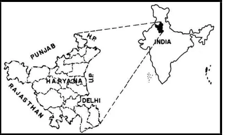
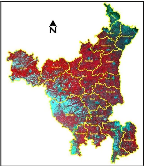
The centre was declared as a nodal agency of the Department of Science & Technology, Government of Haryana for Remote Sensing and GIS applications in 2007. HARSAC being the pioneering Institute has its goal to convert the space image to implementation plans through human capacity building in Natural Resource Management. The working domain of the centre is basically Haryana but can take up various projects in other states also depending on the need. The location map of the state and a view of satellite data is given below in Fig. 1 and Fig. 2 respectively.
Figure 1. Location map of the study area
Haryana state, which is one of the northern states of India, covers a total area of 44,212 sq kms and lies between 270, 35’ to 310, 55.5’ N latitude and 740, 22.8’ and 77035.6’ E longitudes. It is bounded by natural features as Siwaliks in North, Aravallis in South, Yamuna River in East and Ghaggar in West. The area is covered by Survey of India toposheets Nos. 44K, 44O, 44P, 53C, 53D, 53F, 53G, 53H, 54E. Except the hilly portions, most of state lies between 200 to 300 meters above mean sea level. The average slope of the terrain is northeast to southwest however the slope in northern portion is towards south and in south it is towards north making it almost saucer shaped physiography. It mainly occupies Indo-Gangetic water divide and major portion is covered by Indo-Gangetic alluvium. Ghaggar, Tangri, Markanda, Saraswati and Chautang originate in Siwaliks in the north, Yamuna is the only perennial river making its eastern boundary. Sahibi, Krishnawati and Dohan are non-perennial rivers originating in the south in Aravalli hills of Rajasthan. Haryana is an agricultural state with 88% of the total geographical area under cultivation and cropping intensity of more than 150%. Dominant food crops in the state are wheat, paddy, maize and gram. The state was also affected by floods in 1995. The districts affected were Bhiwani, Faridabad, Gurgaon, Hisar, Jind, Kaithal, Karnal, Kurukshetra, Panipat, Rewari, Rohtak, Sirsa and Sonipat.
The physiography of the state makes it more pertinent to have such type of facility located in the state that too in the campus of CCSHAU, Hisar so that there can be adequate coordination between these organisations to help the state in a better way. More than 98% area of the state is covered by the alluvial plain. Large part of the Haryana plain constitutes a widely spaced topographic depression between Shiwalik and Aravalli hills, almost a flat topography on regional level and poor drainage system. The absence of the surface and subsurface drainage is remarkable in the wide spread central and western part of the state due to peculiar topographic conditions and low rainfall. International Archives of the Photogrammetry, Remote Sensing and Spatial Information Sciences, Volume XXXIX-B6, 2012
XXII ISPRS Congress, 25 August – 01 September 2012, Melbourne, Australia
This gives rise to the rising trend of water table in these areas. The basic reason behind seems to be the poor quality of ground water which makes it almost unusable for even irrigation purpose. This problems is compounded with plenty availability of surface water. The surplus water further recharge the ground water and this is leading to water logging at certain places. However, the northern and southern parts of Haryana State are facing the problem of water level decline due to over exploitation of fresh ground water.
Various studies have been carried out a number of authors from India and Abroad regarding the issues related o challenges and Opreationalization of Geomatics education (Chaudhary et al 1999; Chaudhary et al 2008; Chaudhary & Aggrawal 2009; Chaudhary, 2011 a, b; Dan Klang 1998; Harmsen & Nidhumolu, 2002, Goyal & Chaudhary 2010 and Sethi et al 2011 etc.).
Figure 2. Haryana state as viewed by satellite
3. KEY ISSUES
The remote sensing and GIS activities in Haryana are synonymous with HARSAC. After the establishment of HARSAC, there were many projects in the beginning with the sponsorship and collaboration from ISRO/SAC/NRSA/DST as part of their ongoing projects in India. These include, digital land use/ land cover mapping, crop acreage and production estimation, survey of natural resources under National (Natural) Resources Information System (NRIS) phase I & 2, watershed mapping in different parts, forest mapping etc. The initial two decades have witnessed a steady increase in the number of projects being carried out in various thematic fields. However in the later part of the second decade, it was devoted to digital data base creation under NRIS phase II and IRIS-DA, coupled with more innovative projects like Natural Resources Census. There was a need for making the users aware and get them trained in the usage of these latest techniques for the better solutions for site specific natural resources planning. The target audience vary from high level administrators and professional scientists
to application oriented personnel and technicians. If decision makers are made aware about the potential of these technologies, their formal training in these emerging technologies will motivated to accelerate the use of this in their respective organizations. Their being on the positions of higher level, it will be easier to assimilate/ integrate these technologies in a better and efficient manner.
On the other hand there was a need to start a course in academics so that the trained manpower might have been produced in the state to cater the needs of different departments/ institutions. This led to the genesis of having introduced a course in Geoinformatics by HARSAC in collaboration with GJUS&T, Hisar. This is four semester M.Tech. Geoinformatics in dual mode where the university will be awarding degree whereas the HARSAC will be providing practical as well as teaching facilities.
In other universities like MDU, Rohtak and K.U. Kurukshetra and Chaudhary Devi Lal University (CDLU), Sirsa the existing departments and affiliated colleges introduced a full paper in the departments of Geography, Geophysics, Geology, Environmental sciences and Botany covering the RS, GIS and GPS way back in early nineties. This led to the extension of this discipline to a full fledge PG diploma in MDU, Rohtak in the department of Geography. It was further extended to M.Tech. in Geomatics since academic session 2010-2011. An affiliated college to K.U. Kurukshetra also started PG Diploma in 2007 but could continue only for two years and has to be abandoned due to lack of potential admission seekers in the course. While browsing through the course curriculum, it appears that all the care has been taken regarding the updated contents depending on the requirements of the industry and current market.
4. WAY AHEAD
While analysing the faculty requirement for catering the needs of the students both across the Institutes/ departments, it was found that they lack heavily in this respects. The deficiencies range from less number of faculty to that of lack of trained faculty and at places lack of sufficient infrastructure. Some of the prestigious institution in the state catering to the needs of the market of trained manpower in Geoinformatics also lack heavily in terms of availability of trained teaching faculty.
Another important aspect coming to the fore was lack of coordination between the academic institutions and the only available space application centre in the state. Even the research finding available in the centre were not finding much head way to the academic institutions in terms of their inclusion in the academic curriculum.
This requires deeper level of involvement while catering the needs of Geomatics community at the larger level in the state. There is a need to reassess the real needs/ requirements at various levels and in various domains. The first and foremost is the requirement of a sufficient number of well trained faculty at various institutions to cater the needs of the optimal number as per well established norms of UGC/AICTE. The syllabus of the same course in various institutions should have the common syllabi and if possible common entrance test so as to bring the parity in teaching and standards. The infrastructural facilities available at various Institutions should be strengthened in commensurate with the requirements of the course type and number of students. There is a strong need of well coordinated efforts between HARSAC and the academic institutions so as International Archives of the Photogrammetry, Remote Sensing and Spatial Information Sciences, Volume XXXIX-B6, 2012
XXII ISPRS Congress, 25 August – 01 September 2012, Melbourne, Australia
the maximum/ optimum utilisation of various resources/ finding available can be made for managing the natural resources of the state in a better and more scientific manner and also to create the level field for the availability of well trained manpower in the field of Geomatics.
There is a strong need of making the people aware of the applications of Geomatics in their respective disciplines/ domains and promoting cutting edge research by employing the available techniques. The nature of synergy in the form of Geomatics will go a long way in the disciplines which requires the spatial domain as one of the input. The strong nature of Geomatics in the way of handing large volumes of data for not only storage purpose but for customization, query and analysis, integration and visualization can be wonderful for the planners and decision makers.
Looking to the needs in the state of further research in the field of water resources both surface as well as ground water makes it imperative to address various thrust areas by employing these techniques in a subtle manner. The naturally occurring problems due to its physiography/ topography associated with the indiscriminate use of water/ fertilizers, pesticides, herbicides and insecticides due to advent of green revolution a requires attention at much deeper level of integrated technology usage by associating people from different expertise/ disciplines. The refinement in the rainfall-runoff models catering the local needs to mitigate the fury of floods requires immediate attention. The need of risk zonation maps of the area with respect to natural as well as man made disasters us another area of concern. The northern and southern districts require immediate measures for artificial recharge of ground water to augment fast depleting water resources in the state. The site selection for various structures can be meaningfully done by employing the Geomatics. The central areas which are facing a great threat of white desert (Salinization/ water logging) require the problem to be tackled at different levels. The conjunctive use of both ground and surface water can be the viable solution but in what manner and in which areas requires site specific plans to be drawn. These can be addresses in a better and efficient manner using Geomatics for the purpose.
5. CONCLUSION
The above discussions make it clear that the Geomatics education in the state of Haryana needs a rethinking and re-look so as to make it more practicable. There is a need of great impetus/ thrust to redress these issues at a deeper level. The Geomatics education in the state needs uniformity in syllabi/ curriculum development and requirement of trained and sufficient number of faculty so as to create well trained professionals in the field to cater the needs of the industry/ market in this area. There is a need to make it more comprehensive and accessible. A strong interface between academia, industry, Govt. departments and research institution in the state, Non-Governmental organizations, user departments is the dire need of the hour which should have more with strong linkage with the national institutions.
References:
Chaudhary, B.S.; Arya, V.S.; Beniwal, A.; Babu, T.P. and Ruhal, D.S. (1999): Satellite Applications in monitoring flood hazards in Haryana, India- A Case study. Operational Remote Sensing for sustainable development. A.A. Balkema/ Rotterdam/
Brookfield/ 1999. Edt. G.J.A. Nieuwenhius, R.A.Vaughan and M.Molenar. P. 281-284.
Chaudhary B. S., G.P. Saroha and Manoj Yadav (2008) “Human Induced Land Use/ Land Cover Changes In Northern Part of Gurgaon District, Haryana, India: Natural Resources
Census Concept”. Int. Jr. of Human Ecology 23 (3), pp. 243-252.
Chaudhary B. S., and Sandeep Aggarwal (2009) “Demarcation of Palaeochannels and Integrated Ground Water Resources
Mapping in Parts of Hisar District, Haryana” Springer J. Ind. Soc. of Remote Sensing. Vol. 37:251-260.
Chaudhary B.S. (2011) “Geoinformatics Application in Sustainable Water Resources Management: Indian Scenario” Nat. Conference on “Geo-sciences and Water resources for sustainable development” Feb. 11-12, 2011, Andhra University, Vishakhapatnam, India. PP. 53-60
Chaudhary B.S. (2011) “Opreationalization of remote sensing and GIS for ground water exploration and management: Few
examples from Haryana State, India” International conference on “Ground water: Source of security in an uncertain future”
Sept. 19-21, 2011, Pretoria, South Africa (E-Proceedings).
Dan Klang (1998); Automatic Detection of Changes in Road Databases using Satellite Imagery, IAPRS, Vol. 32, Part 4 “GIS
-Between Vision and Applications”, Stuttgart, 1998, pp. 293 -298
K. Harmsen and B. N. Nidhumolu “Land use planning for sustainable development in South Asia: An example from India,” IAPRS & SIS,
Vol. 34, Part 7, “Resource and Environment Monitoring,” Hyderabad, India. 2002, pp. 1467-1473.
Goyal S. K.; Chaudhary, B. S. (2010): “GIS based study of Spatio-Temporal changes in groundwater depth and quality in
Kaithal district of Haryana, India” The Journal of Indian Geophysical Union, Volume 14 No.2 April 2010, pp. 75-87.
Sethi G. K.; Chaudhary,B. S.; Goyal S. K. and Thakur P. K.
(2011): “Suitability Analysis of Groundwater Quality for
Domestic and Irrigation Usage in Yamuna Nagar District, India:
A GIS Approach” Springer J. Ind. Soc. of Remote Sensing
Published online 29th June 2011. DOI: 10.1007/s12524-011-0116-0.
Rao, U.R. (1989): Space and Flood management. Ibid. pp. 1-7.
Acknowledgements
The author is thankful to the scientific colleagues at HARSAC, Hisar specifically Dr. R.S. Hooda, Dr. VS Arya, Dr. Manoj Yadav, Dr. TP Babu and Dr. KE Mothi Kumar during his stay at HARSAC, Hisar. The author is also thankful to Prof. S.S. Teotia, Dr. Dinesh Kumar, Dr. R.C. Patel, Prof. Nand Lal, and Dr. M.S. Jaglan, the colleagues in Kurukshetra University, Kurukshetra for discussions during course of preparation of this manuscript.
International Archives of the Photogrammetry, Remote Sensing and Spatial Information Sciences, Volume XXXIX-B6, 2012 XXII ISPRS Congress, 25 August – 01 September 2012, Melbourne, Australia