TOPIC MAP EXISTING TOOLS: A BRIEF REVIEW
by
Athanasios Hatzigaidas, Anastasia Papastergiou, George Tryfon , Despoina Maritsa
Abstract. Topic maps (TM) are a new semantic approach to information organisation and they were designed to enhance navigation and information retrieval in large sets of information resources. The steady increase of interest on behalf of the academic world and the industry to exploit the potentials of TM technology, resulted to a proportional increased need for developing software tools in order to facilitate the creation, editing and management of topic maps. Furthermore, navigation and representation of topic maps and consequently tools to support these functions is also a necessity. In the context of this paper we present a brief review of existing TM tools in order to set the boundaries on what should be included in an efficient TM software application tool, consequently evaluate their shortcomings and accordingly give a few basic directions regarding the level of functionality that such a tool would be expected to provide.
Keywords: topic map, editor, tool, navigation, representation, visualization
Introduction
Semantic Web, Tim Berners-Lee’s future vision of the Internet is an extension of the existing web, aiming to create a technology to enable machines to interpret and process Information in the web, and through this to support humans in carrying out their various tasks with the Web [1]. Towards this direction several semantic web technologies have been developed for describing and annotating resources on the Web in standardized ways.
Topic maps (TM) as a new semantic – ontological approach to information organization, describe knowledge structures and associating them with information resources [2,4,5]. TM were designed to enhance navigation and information retrieval in complex data sets by adding semantics to these resources [2,3]. They allow us to model and represent knowledge in an interchangeable form, and they provide a unifying framework for knowledge and information management [6,9]. TM enables the capture of knowledge to be visualized and published as they are defined by using well structured, internationalised and extensible interchange syntax [6].
information. They can also be used for knowledge management, web portal development, content management, and enterprise application integration [9].
Although there is an increasing interest on behalf of the academic world and the industry the potentials of topic maps would be very limited without effective tools to help users manage their topic maps. Topic map technology seem to be promising, but creation of topic maps is not a simple task, and there is an increased need for developing tools for creating, editing and managing topic maps. Furthermore, the issue of Topic Maps navigation and representation and consequently tools to support these functions , is also essential.
In the first section of this paper we briefly present TM basic concepts, describe the main issues for topic map development and then we make a brief review of the existing TM tools and consequently knowing their shortcomings we conclude to the main key features that an efficient and intergraded Topic map software application tool should encompass.
Topic Maps basic concepts
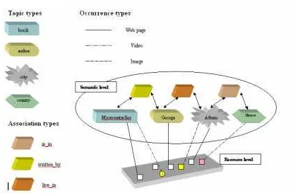
Figure 1. Example of Topic Map
Topics is the basic concept in topic maps and represents a subject [5,6] Topics can be categorized according to their kind to types. Figure 1 represents a very small Topic Map which contains four topics: Microcontrollers, George, Athens, Greece. These topics are instances of other topics: Microcontrollers is a book, George is an author, Athens is a city, and Greece is a country.
A topic may be linked to one or more information resources e.g. web pages, video, images, which are relevant to the topic in some way. Such resources are called occurrences of the topic. Occurrences are also categorized according to their kind. In the Topic Map represented on the figure 1, occurrences of the topic Athens may be URLs pointing to some images. Occurrences help organise data by linking real resources to abstract concepts. It must be noticed that topics and information resources belong to two different layers[5,7].
association called the association role. An association adds semantics to data by expressing a relationship between several topics, such as Microcontroller written_by George, Athens is_in Greece, etc. An association may have any number of roles and can thus easily express more complex relationships[6,7].
The special characteristic of the Topic Maps model is the clear separation between the description of the information structure and the physical information resources [11]. Topic Maps describe the information at the Semantic Level, and maintains the information objects at the Resource Level (Figure 1), enabling enhance navigation and information retrieval.
Additionally topic map, and in particular the notion of published subject indicators promotes interoperability across applications and also allow explicit representation of context or viewpoints through the use of scopes. Furthermore topic maps were designed from the start for ease of merging. [6,8].
Topic Maps Software Development
Topic Map Technology is becoming more and more popular across the globe, hence developers of the technology have come up with various tools that make use of the technology. To delve into the world of Topic Maps we need four steps, namely the design and editing, the navigation, the visualisation and the querying. Hereafter we shall describe these four steps.
Design and editing Topic Maps
This is the first step. The design process depends on the information resources, hence it is important to understand the context and the real meaning of the information in order to create a consistent Topic Map. So, going through the resource, the designer identifies topics (topics types), occurrences (occurrence role types) and associations (associations types) [3,7].
A Topic Map designer/author in order to write XTM code should have an explicit understanding of XTM syntax and specifications [2,8] He should also be very careful with trivial things like well formed-ness of the document or the numerous tags which distracts him from the concentration on quality and coherence of the authored topic map which is by default a difficult task [10] . Hence, to authoring topic map, there is a necessity of having a tool that provides an easy-to use GUI (Graphical User Interface) that makes the authoring process more intuitive so the user can focus his attention to the semantics rather than the syntax of the Topic Map.
occurrences. This tool should allow, enabling import, browsing, manipulation and export of existing Topic Maps or creation and export of new topic maps. A list of the topics, associations, occurrences, scopes, etc could be presented and features like add, remove, rename and delete would be available for manipulating such characteristics of the topic map.
Representation and Navigation of Topic Maps
This is the second step. The delivery of information resources, using the topic map, i.e. structured information, allows several new features. The information retrieval has a very significant importance. At this step, the topic map is already a reality and so what matters now is to display the information in the desired way and how to access the information stored. The way that information is displayed to the user is very important, it should be done in a clear way so that he understands how to navigate trough it until reaching to the desired one. Using topic maps for navigating in large information sets requires an “easy-to-use and an easy-to understand user interfaces” [8,10]. User interaction, different ways of output and navigation, and rapid searches retrieval, make navigating processes easier.
For an efficient navigation, the whole Topic Map should be represented in order to help users understand it globally. Thus, users should be able to focus on any part of the Topic Map and see precise information about a specific topic. Providing different representatives forms requires the use of different levels of detail, so users should be able to navigate freely and intuitively at these different levels of detail. This can be achieved by displaying several windows simultaneously offering the opportunity to the user to select the most appropriate representation at a given level of detail [11].
Visualization of Topic Maps
For an efficient representation and consequently navigation of topic map, special techniques needed as it is not only a matter of efficient navigation, but also providing a conceptual image of the stored data. The research and investigation in this field is concerned with the development of strategies and approaches in order to visualize information sources and data as a means toward helping people interpret and understand the information[11,13].
dimensions of nodes and arcs of the graph [11,12].
Nevertheless as topic map may contain million of topics and associations, it is necessary to provide graph visualisation in a more enhanced way. Munzner [14] proposed to use hyperbolic geometry instead of euclidian geometry, which allows to display a very large number of nodes on the screen. Hyperbolic trees, spiral, cone tree, and others, are some of these developed approaches. Another solution to the lack of space on the screen is to represent Topic Maps in three dimensions. The use of the third dimensional enables the user to have better control over the information to be explored, as dynamic 3D world would respond to the user's movements, bringing most relevant topics nearer and moving others further away as the user's focus changes[11]. According to Ahmed [15] there are two more ways for representing topic maps, the landscapes and the worlds which are two human readily interpretable manners to visualize interconnected meta-data, in 2D and 3D respectably.
Each technique is suitable for a specific level of detail. Some of them may represent efficiently the whole topic map structure while others are better at displaying any part of the topic map.
Querying Topic Maps
One of the strongest characteristics of Topic Maps is their ability to query XTM topic maps or other commercial databases. In the same way as relational databases can be queried, a structured retrieval of Topic Map data, is offered to the TM author using TOLOG language [16]. The ISO SC34/WG3 has put together requirements and use cases on the TMQL home page [17].
This language can query topic maps for topics of specific types, which participate in certain combinations of associations, and supports inference rules. There are three main ways in which TOLOG can be extended:
• by adding new predefined rules like has-type,
• by adding new data types, operators and rules to work with these, and
• by extending the syntax and adding entirely new concepts.
In order to add a predefined rule what needs to be specified is the relationship between the parameters of the rule [16,18].
Different tools, different deliverables
We have distinguished three Topic Maps Tools categories. The first one is the Topic Maps Engines. An engine provides a comprehensive Application Programming Interface (API) to allow
programmers to create and modify topic map structures. It can also be used to import, export and query Topic Maps. Finally, the engine can be used to manage topic maps which are maintained in-memory or which are persistently stored in a database. Although the visualization is not considered as a part of an engine, most of the engines provide this feature as an asset for easier
implementation and use of the topic maps.
The second category of tools is the Topic Maps Navigators (or visualization tools). These are tools that enable the user to see and navigate through the topic maps. They use different techniques to achieve a human comprehensive view of the topics and the interconnections among them.
Finally, the third category is the Topic Maps Editors, tools that allow the user to create and modify Topic Maps, usually in a text based environment.
Topic Maps Engines [19-29]
GooseWorks.org Toolkit is a library for building applications that deal with various kinds of topic map information. Topic map information is - basically - data that makes statements about addressable resources, e.g. ISO Topic Maps, XTM, NewsML, RDF, DAML. The 'GooseWorks Toolkit for Topic Map Information Processing' is an implementation of the 'Topicmaps.net's Processing Model for XTM' and the correlated Graph3 API by Michel Biezunski and Steven R. Newcomb.
SemanText is a prototype application developed to demonstrate how the topic map standard can be used to represent semantic networks. Semantic networks are a building block for artificial intelligence applications such as inference engines and expert systems. SemanText builds a knowledge base, in the form of a semantic network, from the topic map. New information can be added to the knowledge base and topic map automatically when the user defines rules which are used to infer new knowledge. All of this is done using constructs defined in the topic map standard. Written in Python.
The empolis k42 evaluation provides a full functional and unlimited-in-time version of the empolis k42 knowledge server and its components - the only restriction of the evaluation version is the size of the topic map. The package includes the topic map engine and its persistent store, Web Author for template-based editing, Topic Map View for navigation, and the full documented Java API with support for inference and TMQL.
The Tm4Jscript system runs stand-alone or in a browser. The engine is based on reverse-engineering of xtm into an object model. It is a very straightforward design that uses indexes and hash tables to get performance. There are a number of useful methods that more or less make up for not having a query language. The system consists of the core engine, utilities code, and the editor app. A few other apps are also included. Developed in Javascript.
The tmproc engine is a python implementation of ISO/IEC 13250. It can import, export, query and manipulate of Topic Maps. Full set of extensible topic map classes with clearly defined interfaces. Optional architectural processing [requires xmlarch]. The package contains introduction and reference documentation, as well as statistical and information printing classes. It also comprises a command line utility for interactive exploration. This was the first freely available topic map engine. It doesn't support XTM 1.0. It is free and written in Python.
TM4J is one of the leading open source Topic map engines. TM4J is a small suite of Java packages which provide interfaces and default implementations for the import, manipulation and export of Topic Maps encoded to conform to the XTM (XML Topic Maps) DTD. It now supports both in memory and database stores as well as TMAPI. The project also has a home at Sourceforge where there is an active community of developers and implementers. The goal of the TM4J Project is to develop robust, open-source tools for creating, manipulating and publishing topic maps. The project currently consists of the following sub-projects:TM4J Topic Map Engine, TM4Web, Panckoucke, TMNav
xSiteable is a complete small-to-medium-size site development / prototyping kit created in XSLT, available on a number of platforms and operating systems. It has a simple Notation language for content called xSiteable. Notation, utilizing Topic maps (XTM) for structure, binding and other assorted cleverness and the Sablotron XSLT parser for quick, reliable and powerful processing. This tool is free.
Topic Maps Navigators- Visualisation tools [30-37]
HyperGraph can be used to visualise topic maps. HyperGraph is an open source project which provides java code to work with hyperbolic geometry and especially with hyperbolic trees. It provides a very extensible API to visualize hyperbolic geometry, to handle graphs and to layout hyperbolic trees.
Panckoucke is a java library to support the development of topic map presentation and navigation tools. Panckoucke is a subproject of tm4j and relies on it as its underlying topicmap engine. It integrates tmharvest, another subproject of tm4j, to support the automated creation of topic maps from structured data. Panckoucke is free and open-source (under the Apache Software Foundation license).
ThinkGraph is a mix between a MindMapping application structured display of information and a 2D drawing application.
TM3D visualises Topic Maps in 3D. TM3D is a graphical tool allowing 3D navigation of a XML Topic map. It uses OpenGL and xerces. It is only a viewing tool, with "point and click" functionalities, you have balls of different colours indicating what kind of entity your are viewing and contextuals menus.
TM4Web/Velocity
TM4Web/Velocity is a (TM4J) package for the processing of topic maps to HTML pages (or in fact any kind of text files). The package allows both an off-line batch transformation and an on-the-fly transformation as part of a web application. A sample web application and sample templates for offline and online HTML page creation are distributed as part of the package.
UNIVIT A 3D interactive Topic Map visualisation tool – UNIVIT (Universal Interactive Visualisation Tool) -was implemented by Le Grand and Soto, which uses virtual reality techniques such as 3D, interaction and different levels of detail
TMNav is a subproject of tm4j, a Java application for browsing topic maps. The application can connect to and browse topic maps from any of the supported TM4J backends. The navigation is presented in both a standard swing GUI and a dynamic graph GUI using the TouchGraph library. The new version supports merging topic maps, creating topic mapas and the use of tolog 1.0 language
Topic Maps Editors [38-43]
AsTMa is another plug in language for Topic Maps from Robert Barta. Features like static map authoring, only 'positive' information, similar to LTM, convertible to XTM
The mapalizer is a simple tool (written in Perl) for rapid topic map authoring.
Simple Topic Maps Management is a simple Perl module that store Topic Maps on relational database. It also has a simple built-in web interface to edit topic maps.
Topic Map Designer It's an editor and a graph viewer all rolled into one by Ronald Heckel, a student of Business Informatics at Dresden University of Technology, Germany. Free for the Windows platform.
TMTab is a tab-widget plug-in for Protege which enables the use of Protégé as a topic map editing tool. The plugins current functionality is limited in that it only currently supports the export of XTM files from an ontology developed in Protégé which is based on the "topic map ontology" distributed with the plug-in, but it is flexible enough to allow the use of slots on Protege classes to represent topic names, occurrences or to establish associations between topics. TMTab is free and written in java.
General Assessment
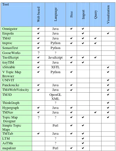
The increasing interest on exploiting the potential of TM technology resulted to an increasing interest of the software developer community for Topic Maps technology. The motivation of this work is to make a brief review of the existing software tools for topic map and outline some general conclusions (Table 1).
Tool
Web based Language
F
ree
Import Query
Visua
liz
ation
Omnigator
D
JavaD
D
Empolis
D
JavaD
D
TM4J
D
JavaD
D
D
tmproc
D
PythonD
D
D
SemanText
D
PythonGooseWorks
?
?Tm4JScript
D
JavaScriptD
D
D
tinyTIM
D
JavaD
D
xSiteable
D
XSTLD
V Topic Map
Browser
D
Python
D
D
UNIVIT
D
Panckoucke
D
JavaD
D
TM4Web/Velocity
D
JavaD
D
TM3D OpenGL
XML
D
ThinkGraph ?
D
Hypergraph
D
JavaD
D
TMNav
D
JavaD
D
D
Topic Map Designer
?
?D
D
D
Simple Topic Maps
Perl
D
D
TMTab
D
JavaD
D
LTM ?
D
AsTMa ?
D
[image:12.595.104.505.77.597.2]mapalizer Perl
D
D
We could categorize the potential TM end users to two different kinds. Those that just browsing and using TM as a way to find information and those administrating a TM.
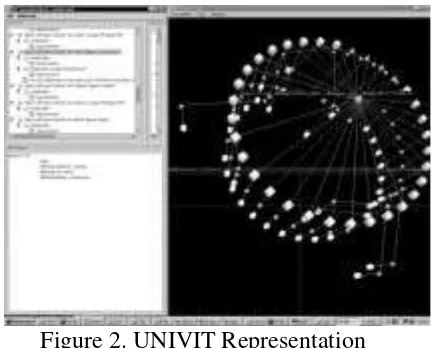
[image:13.595.203.422.179.353.2]For browsing there is a need of a software application that should be able to provide a good representation of the topic maps and easy multi-modal access and navigation. This requires a good conceptual visualisation of the topic map.
Figure 2. UNIVIT Representation
Most of the existing visualisation tools attend to meet the requirements that have been mention in previous section of this paper, for a sophisticated browsing and visualisation of topic map structures. We have distinguished UNIVIT (Figure 2), TM3D and TMNav. In addition some of these tools such as TMNav support also some extra functions such as tolog queries and merging of topic maps.
On the other hand the TM administrator needs an integrated software tool which would also enable efficient management of topic map. The tool should provide the user/developer with a friendly visual environment for the creation and maintenance of the topic maps, a task which can become harsh if only a text based editor is utilized, compliant with Topic Map DTD and XTM specifications.
better to be cross platform portable and compatible, and able to work in a standalone mode.
We have briefly explored the aforementioned tools available to the potentials developers/users who want to exploit TM technology, and knowing their shortcomings, we haven’t been aware of the existence of a complete free software tool for the creation, manipulation, navigation, visualization, querying and merging of topic maps.
Evaluating the functions that existing tools offer to TM administrators, we have concluded that an ideal software application tool should comprise all the following attributes and capacities:
The application should be better to be a standalone windows executable and not a minimalist java applet offering an advanced and friendly graphical user interface. Moreover, the tool should enable the programmatic creation, manipulation and delivery of topic map structures plus allow the creation and management of new topic maps or opening ones that already exist. Furthermore, features like add, remove and delete must be available for manipulating such characteristics of the topic map.
The tool should provide the capability of browsing and navigating through topic maps in an efficient way within various representation forms. The browser needs an interface where the TM is displayed as a graph or a tree, in order to help users understand it globally and to reflect the main properties of the structure. Visualization techniques, as it has been mentioned in a previous section, such as hyperbolic trees, spiral, cone tree, landscapes and worlds in 2D and 3D should be considered as feasible solutions.
The best way to benefit from the advantages of each method is thus to provide several levels of details for the representation of Topic Maps. This can be achieved by displaying several windows so the user can select the most appropriate representation form at a given level of detail. A very useful feature would be the possibility to edit and update the topic map in any of these representation forms, and automatically refresh all the other representatives forms.
In addition, such a tool should enable intelligent retrieval of information of TM through the use of rules and queries for even quicker access to the information. Hence this function is essential if a topic maps software application is to be considered complete. Navigation and visualisation of topic map structures should be taken rules and queries under consideration for better filtering of information
Additionally, the application should provide a portal to the internet for easy topic maps publication. Finally this application should be compatible with other systems in order for the potential users to acquire full benefit of it.
Conclusion
The Topic Map technology has become a standard as a new type of knowledge structures for content representation and navigation and it increasing gains popularity. Nevertheless in order to realize and exploit the potentials of this new technology, the need for software development to manage topic maps is indispensable. In the context of this paper we have attempted to make a brief review of the existing topic map tools and outline some key factors regarding the level of functionality that an integrated TM software application tool would be expected to provide. With time many new applications will evolve, and then the TM technology may enable meaningful navigating and structuring large amounts of information.
In keeping with the main design principles mentioned above, we are in progress of developing a software application tool for efficient Topic Map editing, browsing, management, querying and navigation. Further work needs is currently under progress in the exploring and adding enhanced functions in order to integrate a complete suite.
References:
1. Berners-Lee, T., Hendler, J. & Lassila, O. (2001) The semantic web, Scientific American, 279 (5), 34-43.
2. Biezunsky, M., Bryan, M., Newcomb, S., (1999). ISO/IEC FCD 13250:1999 – Topic Maps, www.ornl.gov.
3. Biezunsky, M., (1999). Topic Maps at a Glance, in: Proc. of XML Europe 99.
4. ISO 13250, (2000)International Organization for Standardization, ISO/IEC 13250, Information technology — SGML Applications — Topic Maps (ISO, Geneva 2000)
5. XTM 1.0 ,Pepper, S. and Moore, G (2001): XML Topic Maps (XTM) 1.0 TopicMaps.Org, http://www.topicmaps.org/xtm/1.0/
7. Moore G. (2000). Topic Map technology - the state of the art. Proc. of XML Europe, Paris http://www.infoloom.com/gcaconfs/WEB/paris2000/S22-04.HTM, June 2000
8. Rath, H.H. (1999) . Technical Issues on Topic Maps, in: Proc. of Metastructures 99 Conference, GCA, Alexandria, VA
9. Garshol, L.M., (2001) Topic maps, RDF, DAML, OIL, A comparison. XML Europe 2001, http://www.ontopia.net/topicmaps/materials/tmrdfoild 10.Rath, H.H. (1999) Technical Issues on Topic Maps, in: Proc. of Metastructures 99 Conference, GCA, Alexandria, VA
11.Le Grand, B., Soto, M., (2000). Information management – Topic Maps visualization, XML Europe 2000, Paris, France.
12.Le Grand, B., Soto, M., (2001). XML Topic Maps and Semantic Web Mining, Semantic Web Mining Workshop, ECML/PKDD 2001 conference, Freiburg, Germany.
13.Lin, X. and Qin. J., (2002). Building a topic map repository. In: Knowledge Technologies Conference, March 11-13, 2002, Seattle, Washington.
14.Munzner, T., (1997). H3: Laying Out Large Directed Graphs in 3D Hyperbolic Space, IEEE Symposium on Information Visualization.
15.Ahmed, Kal (2000). Topic Maps for repositories, XML Europe 2000 Proceedings
16.Garshol, Lars Marius, (2001) TOLOG, a topic map query language, http://www.ontopia.net/ [Moore, Graham, RDF and TopicMaps: An Exercise in Convergence, In XML Europe 2001, Berlin]
17.TMQL home page http://www.isotopicmaps.org/tmql/
18.Ann Wrightson and Hans Holger Rath, Requirements for a Topic Map Query Language (TMQL), version 0.6, in the tmql-wg archive
19.Gooseworks http://www.gooseworks.org/ 20.Ontopia http://www.ontopia.net
21.Ontopia Omnigator http://www.ontopia.net/omnigator/models/index.jsp 22.Semantext http://www.semantext.com/
23.empolis k42 k42.empolis.co.uk/
24.TM4Jscript http://tm4jscript.sourceforge.net/ 25.Tmproc http://www.ontopia.net/software/tmproc 26.TinyTIM http://tinytim.sourceforge.net/
27.TM4J http://tm4j.org/
28.AtlasTM Engine http://www.ontopia.net 29.Xsiteable http://shelter.nu/xsiteable/
31.Panckoucke http://www.folge2.de/topicmaps/panckoucke/
32.The V Topic Map Browser http://www.topicmapping.com/newV/newV.cgi 33.Thinkgraph http://www.thinkgraph.com/
34.TM3D http://silpion.dyndns.org/TM3D/
35.TM4Web/Velocity http://tm4j.org/tm4web-velocity.html
36.UNIVIT, Le Grande, Benedicte; Soto, Michel (2000). Information Management – Topic Map Visulisation, XML Europe 2000 Conference Proceedings
37.TMNav http://tm4j.org/tmnav.html
38.AsTMa http://www.shelter.nu/xsiteable/standard-astma.html 39.LTM http://www.ontopia.net/download/ltm.html
40.Mapalizer http://www.topicmapping.com/mapalizer/
41.Topic Map Designer http://www.topicmap-design.com/en/topicmap-designer.htm
42.Simple Topic Maps http://www.geocities.com/xtopicmaps/ 43.TMTab http://www.techquila.com/tmtab/
Authors:
Athanasios Hatzigaidas - Educational Technological Institute of Thessaloniki, Greece, E-mail address: [email protected]
Anastasia Papastergiou- Educational Technological Institute of Thessaloniki, Greece, E-mail address: [email protected]