Partner Institutions:
Indore Development Authority (IDA), Madhya Pradesh Pollution control board, Environmental Planning and Coordination Organization (EPCO)/ Lake Dev. Authority, Madhya Pradesh Urban Services for the Poor (MPUSP), ICLEI, The Energy and Resources Institute (TERI) and National Institute of Urban Affairs
Lead Institution:
TARU Leading Edge Pvt. Ltd. Indore Municipal Corporation (IMC)
Project Summary:
The City Development plan of Indore states that “increasing population pressure is resulting in deterioration of infrastructure facilities, loss of productive agricultural lands, green open spaces, loss of surface water bodies, depletion of groundwater aquifer zones, air pollution, water contamination, health hazards and many micro-climatic changes.” The main objective of this project is “Ensuring availability of local water resources during emergencies.” This would be achieved by developing replicable model for peri-urban lake rejuvenation and conservation. Engaging with multiple stakeholders in lake conservation would be required for catchment treatment and prevention of pollutants flowing in to the lake.
The expected outcomes of the project that would be delivered are, 1) Stabilized/improved water quality and perenniality of the restored lakes 2) The multi stakeholder owned lake restoration technique is replicated in other parts of the city and other cities 3) The method informs policies on urban water body conservation.
These outcome indicators would include; 1) Number of lake conservation restoration efforts initiated by IMC and IDA over the project period 2) Adoption of lake conservation in IDA and IMC’s plans 3) Lake water usage for multiple purposes by local communities, especially poor, during scarce periods 4) State level policy debates over urban lake restoration 5) Lessons from the project to National debate over lake conservation 6) Number of papers published on lake conservation lessons from Indore. 7) Newspaper coverage on the project. Two lakes have been selected for intervention from the identified fifteen lakes. Fact sheets for the lakes are being generated to initiate interaction with the stakeholders of the project.
( 2013 to 2016 ) ( On going project )
Khajrana Lake Talavli Chanda Lake Lasudia Mori Lake Rangwasa lake
Water Quality Survey Lake Area Survey Community Survey HH Survey in Catchment Out of 42 water bodies of Indore city; 15 lakes identified for
Survey and 4 lakes for detail Survey Catchment Demarcation completed in 15 lakes
there was no proper database of Indore’s local water bodies.
The City Development plan of Indore states that “increasing population pressure is resulting in deterioration of
climatic changes.” The main objective of this project is “Ensuring availability of local water resources during emergencies.” This would be
over the project period 2) Adoption of lake conservation in IDA and IMC’s plans 3) Lake water usage for multiple This project would demonstrate following technologies in at least two lakes and their catchments:
1) Delineation of watershed and preparation of integrated water resource management plan
2) Promotion of on-site decentralized waste water treatment systems and solid waste management systems to reduce pollutant loads on the streams.
3) River restoration ecological treatment 4) Lake conservation by
Delineation of the lake areas and prevention of encroachment through IMC/IDA, Lake water quality monitoring
Lake rejuvenation through cost effective and low energy demanding technologies
5) Commissioning of decentralized community owned water treatment systems from surface/ shallow groundwater based systems located downstream of lakes.
All these activities would be taken up with active collaboration of resident welfare associations, real-estate developers and Municipal Corporation.
Implementing Approach:
1) Development of an integrated water balance and quality model at catchment level 2) Building awareness about water related issues and challenges
3) Negotiations for consensus development and role identification 4) Implementation of Lake conservation/restoration activities 5) Monitoring and implementation of adaptive management plan and 6) Dissemination and Advocacy based on lesson learned.
Key Achievements:
Due to rapid urbanization and increasing migration, the resources of Indore city are facing a huge strain. To meet the growing water demand the city has to pump water from the Narmada River, 70km away and yet, large parts are groundwater dependant. Neglect or lack of management of local water resources has led to them becoming defunct. In order to meet the demand in case of emergency it is important that the city have multiple redundant water resources. The issue with management of local lakes was that
there was no proper database of Indore’s local water bodies.
One of the key achievements so far has been the creation of detailed database on all water bodies within Indore. Detailed surveys of 15 lakes including marking and survey of catchment area have also taken place. Currently we are in the process of creating
factsheets and situation report on Indore’s lakes. This information will help in building awareness issues and challenges.
Organisation Details:
TARU Leading Edge Pvt. Ltd is a private research consultancy organization with an expertise is primarily in six core sectors: Disaster Risk Management & Climate Change, Governance & Institutions, Natural Resource Management, Social Development, Urban Development, and Water, Sanitation & Hygiene. Within these sectors we undertake policy analysis, strategy development, action research, programme design, project management support, assessments and evaluations.
ACCCRN was launched in 2008 and is funded by The Rockefeller Foundation as part of their 9-year initiative aimed at building Climate Change Resilience. Climate change resilience is the capacity of an individual, community, or institution to dynamically and effectively respond to shifting climate impact circumstances while continuing to function at an acceptable level. Simply, it is the ability to survive, recover from, and even thrive in changing climatic conditions. ACCCRN works at the nexus of climate change, vulnerable and poor communities, and urbanization.
KHAJRANA TALAB
Administration:
Indore Municipal Corporation
City:
Indore (Madhya Pradesh - India)
Location:
Lat: 22°43’58.04” N Long: 75°54’12.58” E
Example(1): Location of Khajrana Lake
Background of the lake:
Khajrana Lake is located in the heart of Indore city on the Ring Road near Khajrana Ganesh Temple.
Example (2): Satellite view of Lake with inflow, outflow direction & Solid waste dumping area
This perennial lake has an area of 2.58 ha and maximum depth of 7.5m. The Lake has a circular shape with clear embankment, inlet and outlet. The inflow is located on the NE and outflow is provided on the SW that flows into a drainage chamber on the Ring road. It is no longer used for fishing, indicating that water quality has degraded over a period of time.
Current Situation:
This Lake gets filled by storm water runoff during rainy season and by sewage perennially from the catchment.
Figure (1): Open sewage flow to Lake in catchment
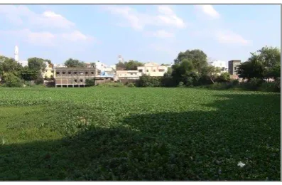
Sewage is contaminating the lake water and it is not used for any domestic use. It has few encroachments, which has reduced the lake area. The lake is used for religious activities such as idol immersion. Some local weeds growing in the lake are used as fodder by the community.
Figure (2): Overgrowth of weeds covers lake water
Significance of this lake:
Urban lakes can serve vital functions ranging from source of water for bathing and washing, recharging groundwater, supporting biodiversity and providing livelihoods to poor households. They serve several environmental, social and economic functions also.
Urban Lakes-if conserved-can meet low quality water needs during normal periods and also can be used as an emergency water supply source after treatment. They also cool the neighborhood, especially in tropical regions during summers.
Figure (3): A Scenic view of Lake
This Lake is an important source for groundwater recharge for the area.
As the catchment has dense population, it could be potentially used as source of water for low end uses and reduce groundwater over-exploitation in the neighborhood.
Lakes are essential to maintain urban microclimate. Restoration of lake would improve the ecosystem as well as provide public space for recreation.
Mosque and temple located in the banks have religious significance and clean lake would add to the aesthetics of the neighborhood.
As the lake is situated in the city, it can provide incomes and livelihoods from outdoor activities.
Current Issues:
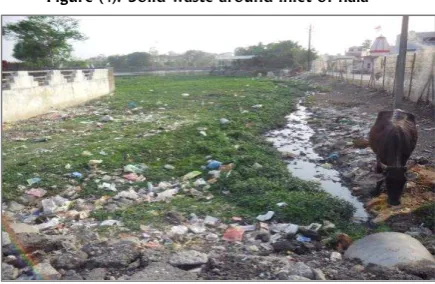
Sewage and solid waste dumped into the lake is leading to water contamination.
Figure (4): Solid waste around inlet of nala
Rapid growth of weeds and eutrophic conditions has reduced fish production.
Dense low and middle income settlements in the catchment and increase in proportion of paved surfaces have resulted in increased runoff and contamination of lake water.
Figure (5): Open sewage and Solid waste in catchment
The road in the catchment has led to diversion of part of the storm water and thus reduced the catchment. There is no storm water line in the catchment.
Open defecation along the south west embankment has created an unhealthy environment.
Potential Stakeholders in Catchment:
The Khajrana area has a population of 18,408 and comprises 3,547 households. Out of these, 2000 households fall in the catchment of Khajrana Lake.
The split of households across different colonies is as follows:
Figure (6): Households in Khajrana Area
Figure (7): Jhalla Colony
Catchment characteristics:
The catchment area of Lake is 36.62 hectares. It has a 1.4 % slopes from East to West. The catchment has 85% roof/paved area which increases the runoff and paved roads act as drainage during the rain. Paved road along the inlet of lake divert runoff from the inlet.
Figure (8): Paved areas in the catchment
Piped Narmada water is supplied to 3,143 (88%) households of Khajrana Gaon, Gandhi Gram, Mamta colony, Laxmi Bagh, Tanzeem Nagar and Jalla Colony, whereas the rest are groundwater dependent. Approximate 15% of households have private bore wells and extract about 223m3 of groundwater per day.
Figure(9): Water Consumption per HH/day in Lts
In the NW edge of the catchment, open sewage flows from east to west and 264 m3 / day grey water is directly discharged into the lake.
Figure (10): Sewerage systems in the catchment
Figure (11): Balai Maholla sewage manhole
The problem of water logging persists in
Conservation efforts done so far:
IMC realizes the importance of the lake and has developed a plan for further development of Khajrana Lake. This plan is essentially focused on development of the lake and banks only.
In 2012, IMC fenced the embankment of the lake to create a walking track. IMC ensures regular cleaning of weeds from the lake. It has plans to divert the sewage entering the lake this year, which may reduce the water levels in summers.
Figure (12): Conservation efforts by IMC
Priorities for conservation:
Urbanization results in major changes in Lake Hydrology as well as water quality. Urban lake conservation is a challenge due to dumping of sewage and solid wastes as well as encroachment. Conservation efforts need to include catchment treatment as well as treating the lake itself to improve water quality. Catchment treatment measures include solid waste management as well as on site and drainage treatment of water input in to the lake.
The priorities for lake conservation are as follows:
Advocacy with IMC to initiate solid waste collection in catchment; especially food waste disposed in to the lake and inlet nalas.
Catchment and nala-treatment of the sewage outlets to improve quality of water flowing into the lake.
In situ bioremediation treatment of the lake water.
Recovery of lost catchment through diverting drainage / storm water line into the lake.
Revival of fishing activities by managing the nutrient status of the lake water.
Creating recreational options to improve aesthetic value of the lake.
Ensuring the ownership by the community, concerned officials, elected representatives and other stakeholders to conserve the lake.
Community-Municipality Partnership can be explored for monitoring, maintenance and conservation of this Lake.
Organisation Details:
TARU Leading Edge Pvt. Ltd is a private research consultancy organization with an expertise is primarily in six core sectors: Disaster Risk Management & Climate Change, Governance & Institutions, Natural Resource Management, Social Development, Urban Development, and Water, Sanitation & Hygiene. Within these sectors we undertake policy analysis, strategy development, action research, programme design, project management support, assessments and evaluations.
ACCCRN was launched in 2008 and is funded by The Rockefeller Foundation as part of their 9-year initiative aimed at building Climate Change Resilience. Climate change resilience is the capacity of an individual, community, or institution to dynamically and effectively respond to shifting climate impact circumstances while continuing to function at an acceptable level. Simply, it is the ability to survive, recover from, and even thrive in changing climatic conditions. ACCCRN works at the nexus of climate change, vulnerable and poor communities, and urbanization.
LASUDIYA MORI TALAB
Village Name:
Lasudiya Mori
Administration:
Lasudiya Mori Gram Panchayat
City:
Indore (Madhya Pradesh - India)
Location
Lat: 22°47’1.31” N Long: 75°54’38.26” E
Example (1): Location of Lasudiya Mori Lake
Background of the lake:
The Lake is located in the Lasudiya Mori village, 10-12 Km from the city center of Indore near Dewas Naka. Lake has tadpole shape with a clear embankment. The submergence area of this lake was 8 hectare and has reduced to 2.85 hectares in the span of 20-25 years due to gradual encroachment. As per Gram Panchayat records the area of this lake is 4.86 hectares. The Lake has a maximum depth of approximately 4.5m.
The lake was seasonal a decade back. It had a well-defined outflow system in NE known
as ‘Mori’. Inlet of storm water is from SW
and West. It was used for domestic purposes by Lasudiya Mori Village.
Current Situation:
The lake has become perennial by sewage from Nayi Basti and catchment diversion from southern area. The major sewage inlet is located on the NW. Sewage inflow in the lake has led to high contamination and pollution of the lake water and limited use of the lake by the community.
Example (2): Satellite view of Lake with inflow, outflow direction & Solid waste dumping area
Fishing is a major livelihood activity in the lake. It is done by SARASWATI Self Help Group, a group of 11 households from the fishermen community. To maintain the fish production; they remove lake weeds like Jalkumbi and sprinkle about 10 quintal of lime per month in the lake to neutralize sewage and pollution.
x
Example (3): Gradual Reduction of Lake Area with Development
Significance of this lake:
This Lake of the city is an important source for groundwater recharge for the area.
As situated along the village and slums; it could be potentially used as source of water for low end uses and reduce groundwater over-exploitation in the neighborhood.
Figure (1): A Scenic view of Lake
Lakes are cooling agents and restoration of the lake would improve the ecosystem, which influences the microclimate of the peri-urban area.
Restoration of lake would increase the fish production led to improve livelihood status of fishermen families.
A temple located along the embankment has religious significance and a clean lake would add to the aesthetics of the surroundings.
Current Issues:
Sewage inflow into the lake is leading to water contamination.
Figure (2): Sewage inflow
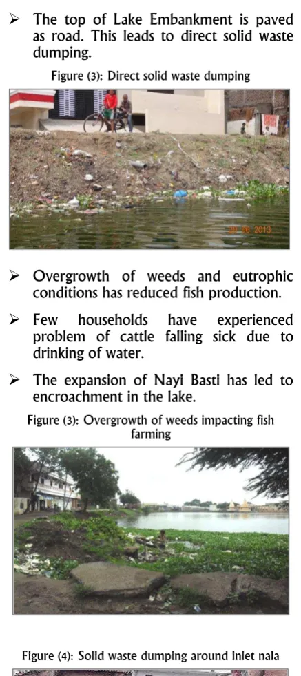
The top of Lake Embankment is paved as road. This leads to direct solid waste dumping.
Figure (3): Direct solid waste dumping
Overgrowth of weeds and eutrophic conditions has reduced fish production.
Few households have experienced problem of cattle falling sick due to drinking of water.
The expansion of Nayi Basti has led to encroachment in the lake.
Figure (3): Overgrowth of weeds impacting fish farming
Figure (4): Solid waste dumping around inlet nala
Figure (5): Encroachment in Lake Area
Potential Stakeholders in Catchment:
The catchment of lake has approximately 390 households live in 185 houses and around 95 commercial and service units. The Nayi Basti comprises of lower-middle and Lasudia Mori village has middle to upper middle socio-economic class households.
Figure (6): Household in Lasudiya Mori Area
Catchment Characteristics:
The total catchment area of lake is about 48.53 hectares. It has 0.5% slope from West to East. Nearly 75% of the catchment area has commercial buildings, whereas the rest are residential. The catchment has 55% open space and 45% roof/paved areas.
The settlements in the catchment are entirely groundwater dependent. There are 4 community bore wells and 10 private bore wells in the Nayi Basti settlements and they extract about 156 m3 of groundwater per day.
Figure (7): Community stand post for water collection
30% Households discharge grey and black discharged in the lake.
Figure (8): Water Consumption per HH/day in Lts
Figure (9): Sewerage Arragements in the Catchment
Water logging can be seen in the catchment behind the Nayi Basti and in commercial area which lasts for approximately 2 months after the monsoon. Some roads in the Nayi Basti also remain water logged as there is no storm water line in the area.
Gram Panchayat has made effective efforts to increase the inflow by restoration of storm water flow from catchment area, earlier cut off by road from the south and south west area of the lake. Also de-silting has been done to increase water holding capacity of lake in 2000-2001. Repair of the embankment was done in 2012.
Urbanization results in major changes in Lake Hydrology as well as water quality. Urban lake conservation is a challenge due to dumping of sewage and solid waste as well as encroachment. Conservation efforts need to include catchment treatment as well as treating the lake itself to improve water quality. Catchment treatment measures include solid waste management as well as on site and drainage treatment of water input in to the lake.
The priorities for lake conservation are as follows:
Catchment and nala-treatment of the sewage inlets to improve quality of water flowing into the lake.
Advocacy with Gram Panchayat / IMC to initiate solid waste collection surrounding the lake especially along the inlet nalas.
In-situ bioremediation treatment of the lake water.
Strengthening of Saraswati Self- Help Group for maintaining and conserving Lake.
Proper demarcation of the lake boundary to arrest further encroachment with fencing.
Creating recreational options to improve aesthetic value of the lake as well as campus of temple.
Ensuring the ownership by community, concerned officials, elected representatives and other stakeholders.
Organisation Details:
TARU Leading Edge Pvt. Ltd is a private research consultancy organization with an expertise is primarily in six core sectors: Disaster Risk Management & Climate Change, Governance & Institutions, Natural Resource Management, Social Development, Urban Development, and Water, Sanitation & Hygiene. Within these sectors we undertake policy analysis, strategy development, action research, programme design, project management support, assessments and evaluations.
ACCCRN was launched in 2008 and is funded by The Rockefeller Foundation as part of their 9-year initiative aimed at building Climate Change Resilience. Climate change resilience is the capacity of an individual, community, or institution to dynamically and effectively respond to shifting climate impact circumstances while continuing to function at an acceptable level. Simply, it is the ability to survive, recover from, and even thrive in changing climatic conditions. ACCCRN works at the nexus of climate change, vulnerable and poor communities, and urbanization.
TALAVALI CHANDA TALAB
Village Name: Talavali Chanda
Administration:
Talavali Chanda Gram Panchayat
City:
Indore (Madhya Pradesh – India)
Location:
Lat: 22°48'7.42"N, Long: 75°55'0.69"E
Example (1): Location of Talavali Chanda Lake
Background of the Lake:
Example (2): Satellite view of Lake with inflow direction and Solid waste dumping area
Talavali Chanda Lake is situated on AB road opposite Ruchi Soya factory. It is a perennial lake of approximately 16.6 hectares area and has maximum depth of around 6m. It has a crescent shape with clear embankment. Earlier, the submergence area of the lake and the surrounding area was clean. At that time, the villagers safely used the lake. In 1988, 2006 and 2012 rainy season, the embankment got damaged leading to flooding of the settlement downstream. A number of migratory birds have been visiting the lake since long.
Current Situation:
The Lake is mainly fed by rain and storm water although sewage from Bajrang Nagar Kankad enters the lake as well. It shrinks to almost 60% during summer. The natural catchment of the lake has been degraded due to development of townships and road network. The lake has no overflow.
Due to uneven deepening and some cases of casualty, the lake is no longer used for bathing. The surrounding environment is no longer clean and has open defecation is done along the embankment. The major livelihood activities in this lake fishing and water chestnut (Singhada) cultivation harvesting. It is also used for religious activities like idol immersion, and human activities like washing clothes.
Figure (2): Community using the lake for clothes washing
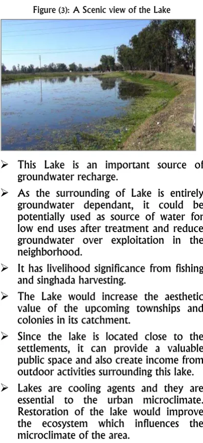
Significance of this Lake:
Urban lakes have very vital functions from being a source of domestic water, recharging groundwater, supporting biodiversity to providing livelihoods to poor households. They serve several environmental, social and economic functions also.
Lake water is an easily available source for the needs in emergency and also, it cools the neighborhood, which is especially relevant in hot summers in tropical regions.
Figure (3): A Scenic view of the Lake
This Lake is an important source of groundwater recharge.
As the surrounding of Lake is entirely groundwater dependant, it could be potentially used as source of water for low end uses after treatment and reduce groundwater over exploitation in the neighborhood.
It has livelihood significance from fishing and singhada harvesting.
The Lake would increase the aesthetic value of the upcoming townships and colonies in its catchment.
Since the lake is located close to the settlements, it can provide a valuable public space and also create income from outdoor activities surrounding this lake.
Lakes are cooling agents and they are essential to the urban microclimate. Restoration of the lake would improve the ecosystem which influences the microclimate of the area.
Current Issues:
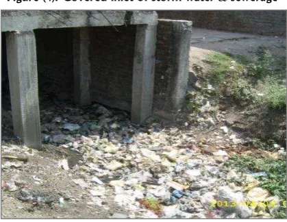
Sewage and solid waste dumped into the lake is leading to water contamination.
Figure (4): Sewage Inflow from Bajrang Nagar Kankad
Water seepage through the embankment leads to water logging on AB road and near houses in downstream.
Figure (5): Water logging in Downstream along the AB road
Overgrowth of weeds and eutrophic conditions has reduced fish production. Lotus weeds are prominent and cover the entire lake.
Open defecation along the embankment.
In case of overflow or flooding, the communities, and Ruchi Soya company, pumps the excess water through pipes and allow it to flow on to AB road leading to water logging. Despite that, flooding has been reported in last few years.
Development of new colonies with storm water lines in the catchment has reduced the catchment.
Potential Stakeholders in Catchment:
The catchment consists of one major settlement called Bajrang Nagar Kankad. Various townships are developing in the catchment such as Casa Greens and Ansal Town. The total number of households in Bajrang Nagar Kankad is approximately 350.
Figure (8): Households in Talavali Chanda Area
Catchment Characteristics: Roof/paved areas cover approximately 23% of the catchment.
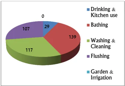
Households in the catchment are groundwater dependant. 20% households have private bore wells and the rest use the community stand post. Total groundwater withdrawal is approximately 117.06m3 per day. All households of Bajrang Nagar Kankad have open sewage for grey water. Approximately 74.16m3/day of grey water is discharged into the Lake.
Figure (9): Water consumption per HH/day in Lts
Figure (10): Bajrang Nagar Kankad
Water logging can be seen on AB road due to seepage and also in parts of Bajrang Nagar Kankad as there is no storm water line in this area. It lasts for approximately 2 to 3 months during monsoon. Storm water line is present in Ansal Town which is connected to the
city’s main storm water line.
Conservation efforts done so far:
De-silting and deepening of the lake has been done by Gram Panchayat. Since the Lake has no overflow, water is removed using pipes to avoid chances of flooding.
Priorities for conservation:
Urbanization results in major changes in Lake Hydrology as well as water quality. Urban lake conservation is a challenge due to dumping of sewage and solid waste as well as encroachment. Conservation efforts need to include catchment treatment as well as
Catchment treatment measures include solid waste management as well as on site and drainage treatment of water input in to the lake.
The priorities for lake conservation are as follows:
Advocacy with Gram Panchayat / IMC to initiate solid waste collection in catchment; especially in sewage inlet nalas.
In situ bioremediation treatment of the lake water.
Lake Catchment treatment to improve inlet water quality.
Constructing a new path for the outflow of the lake to avoid natural and manmade flooding.
Checking the water logging resulting from seepage through repairing of embankment.
Creating recreational options to improve aesthetic value of the lake.
Ensuring the ownership by fishing contractor, community, concerned officials, elected representatives and other stakeholders.
Public private partnership model could be explored by placing suitable mechanism for monitoring, maintenance and conservation of this Lake.
Organisation Details:
TARU Leading Edge Pvt. Ltd is a private research consultancy organization with an expertise is primarily in six core sectors: Disaster Risk Management & Climate Change, Governance & Institutions, Natural Resource Management, Social Development, Urban Development, and Water, Sanitation & Hygiene. Within these sectors we undertake policy analysis, strategy development, action research, programme design, project management support, assessments and evaluations.
ACCCRN was launched in 2008 and is funded by The Rockefeller Foundation as part of their 9-year initiative aimed at building Climate Change Resilience. Climate change resilience is the capacity of an individual, community, or institution to dynamically and effectively respond to shifting climate impact circumstances while continuing to function at an acceptable level. Simply, it is the ability to survive, recover from, and even thrive in changing climatic conditions. ACCCRN works at the nexus of climate change, vulnerable and poor communities, and urbanization.
RANGVASA TALAB
Village Name:
Rangvasa
Administration:
Rangvasa Gram Panchayat
City:
Indore (Madhya Pradesh – India)
Location:
Lat: 22°38'40.74"N, Long: 75°47'22.26"E
Example (1): Location of Rangvasa Lake
Background of the Lake:
The Lake is located in center of Rangvasa village near Rau railway station. This lake is nearly rectangular in shape. The lake boundary is well defined. The area of the lake is approximately 3.8 hectares and it has a maximum depth of 6m. This lake used to be a perennial about 20 to 25 years ago and it was managed by the community. A bathing Ghat was built on the lake signifying its importance to the community. Earlier fishing and water chestnut (Singhada) cultivation was being done. It still holds importance for the community for religious purpose and day to day socializing.
Current Situation:
The Lake has become seasonal due to increased percolation rate after over de-silting and now it holds water for only 3-4 months in a year post monsoon.
Example (2): Location of Lake in the settlement
Example (3): Satellite view of Lake with inflow, outflow direction & Solid waste dumping area
Figure (1): Red wattled Lapwing
Significance of this Lake:
Figure (2): A Scenic view of the lake
This lake is an important source for groundwater recharge.
Since the village is entirely groundwater dependent, it could be potentially used as a source of water for low end uses after treatment and reduce groundwater overexploitation in the village.
It is a source of drinking water for cattle.
Lakes are cooling agents and they are essential to the urban microclimate. Restoration of the lake would improve the ecosystem which influences the microclimate of the area.
Since the lake is located in the center of the village and is used for day to day socializing, it can provide a valuable public space.
Figure (3): Inflow Nala
Current Issues:
Sewage and solid waste dumped into the lake is leading to water contamination.
Lack of proper maintenance of covered inlet drainage is the main cause for reduction of water inflow.
The water retention capacity of the lake has reduced due to uneven heavy de-silting.
Figure (4): Covered inlet of storm water & sewerage
Figure (5): Religious waste dumping in the Lake
Religious waste is dumped into the lake.
Foul smell and mosquitoes are other issues faced along the inlet and neighborhood of the lake.
Potential Stakeholders:
The Rangvasa village has total 1400 households, which are further subdivided into six settlements. Out of these about 500 houses are located in the catchment of Rangvasa Lake. The distribution of households across settlements is as follows:
Figure (6): Households in Rangvasa area
Catchment Characteristics: settlements in the catchment are entirely groundwater dependant. Approximately 40
households are connected to the covered storm water inlet and discharge grey water into the lake. Through the inlet 10.25m3 of grey water is discharged into the Lake per day.
Figure (7): Water Consumption per HH/day in Lts
Piped water supply through an over- head tank serves 550 households of the village and the water supply system is managed by the Gram Panchayat. The rest use more than 600 private bore wells. The total groundwater withdrawal is 550.56m3/day.
Figure (8): Sewerage Arrangement in Catchment
The problem of water logging persists only on empty plots in the village and lasts approximately 2 months during the monsoon.
Conservation efforts done so far:
Priorities for conservation:
Urbanization results in major changes in Lake Hydrology as well as water quality. Urban lake conservation is a challenge due to dumping of sewage and solid wastes as well as encroachment. Conservation efforts need to include catchment treatment as well as treating the lake itself to improve water quality. Catchment treatment measures include solid waste management as well as on site and along the drainage treatment of water input in to the lake.
The priorities for lake conservation are as follows:
Advocacy with Gram Panchayat / IMC to initiate solid waste collection in catchment; especially covered inlet Nala.
Catchment and covered sewage inlets maintenance and treatment to increase inflow and improve quality of water flowing into the lake.
In situ bioremediation treatment of the lake water.
Leveling in the submergence of the lake to increase the water retention capacity and reduce percolation rate of the lake.
Creating recreational options to improve aesthetic value of the lake.
Ensuring the ownership by community, concerned officials, elected representatives and other stakeholders.
Organisation Details:
TARU Leading Edge Pvt. Ltd is a private research consultancy organization with an expertise is primarily in six core sectors: Disaster Risk Management & Climate Change, Governance & Institutions, Natural Resource Management, Social Development, Urban Development, and Water, Sanitation & Hygiene. Within these sectors we undertake policy analysis, strategy development, action research, programme design, project management support, assessments and evaluations.
ACCCRN was launched in 2008 and is funded by The Rockefeller Foundation as part of their 9-year initiative aimed at building Climate Change Resilience. Climate change resilience is the capacity of an individual, community, or institution to dynamically and effectively respond to shifting climate impact circumstances while continuing to function at an acceptable level. Simply, it is the ability to survive, recover from, and even thrive in changing climatic conditions. ACCCRN works at the nexus of climate change, vulnerable and poor communities, and urbanization.