Land Degradation Evaluation as an Effort toMitigate Climate Change Mitigation in Medan City North Sumatra Indonesia
LAND DEGRADATION EVALUATION AS AN EFFORT TO
MITIGATE CLIMATE CHANGE
MITIGATION
IN MEDAN CITY,
NORTH SUMATRA PROVINCE, INDONESIA
ABDUL RAUF1* AND RAHMAWATY 2
1Agroecotechnology Study Program, Faculty of Agriculture, University of Sumatera Utara, Jl. A.Sofyan No. 3 Kampus USU, Medan 20155, Indonesia email: [email protected] 2Forestry Study Program,Faculty of Agriculture, University of Sumatera Utara, Jl. Tri Dharma Ujung
No. 1 Kampus USU, Medan 20155, Indonesia email: [email protected] *Corresponding author
ABSTRACT
As the capital city of North Sumatra Province, Medan’s dense population and settlements City with an area of 26,510 ha (3.6% of the total area of North Sumatra) has 21 districts and 151 subdistricts. The density of population and settlement, as well as its flourishinghighindustrial and trading activities economic activities (industry and trade)aresignificantly contributing to rapid highly influential to land degradation. This study was aimed to evaluate the land characteristics and uses of land,to analyze the main causes of land degradation, and to explore efforts in preventingland degradation in Medan City. This study was cConducted in June to October 2014, the study coveredon various types of land use, such as residential, industrial, and commercial areasas well as the areas for food crops, horticulture, permanent vegetated lands (parks, green open spaces, mangrove forests and urban forests). The study was conducted using a Ssurvey method method was used to collect primary data and soil samples by purposive sampling. From each type of land use, at least three observed points were taken as a minimum of 30 sample points. The results showed that the rate of erosion on dry land in the area(which area?) ranged from 1.86 to 29.06 tons/ha/yr.The critical area of 5.15 ha (0.02%) while the potential critical of 21219.35 ha (74.99%) and the moderate critical area of 7,071 ha (24.99% of the total land area of Medan). These findings provided options to maintain the quality of land So that land in Medan City maintained its quality then some action needs to be done, such as:proper land use according to land characteristics and the capability, increasing the of number of tress, prevention of pollution, both by domestic sewage and industrial waste through the application of environmentally friendly technologies, maintaining mangrove forests andland utilization balance between the interests of technical civil (building) and aspects of vegetative (green open space).In order to mitigate climate change in Medan City, it is important to evaluatedland degradation as one of the efforts of climate change mitigation.
Keywords: Climate change, environmental, Medan City, mitigation, prevention
INTRODUCTION
Medan city, which is the capital of North Sumatra province, has with an area reaching 26,510 hectares (265.10 km2), or 3.6% of the total area of the province. North Sumatra, aA large part of the City is in the lower reaches of the Deli watershed, a small portion is in the lower reaches of the Belawanwatershed (West) and in the downstream Percutwatershed (eastern). Medan city has 21 sub-districts and 151 villages with a large
population that is quite large, which amounted to of 2,109,339people soulsat night and during the day could reach 2.5 million.Being With its position in the downstream of Deli
watershed, and Percutand BelawanWatersheds which have is accompanied by dense population and settlements, as well as high and diverse economic activitiesy and diverse(mainly industry and trade), environmental enables damage (degradation)is
Commented [SD1]: Please check, if the the abstract is improved
& full paper is written by paying attention to the Reviewers’
comments in the reviewed abstract: Reviewer 1
Generally is good, full paper must reflect the abstract content. Reviewer 2
This abstract explained the necessary information of the research, but not yet showing the relation with the topic selected. The full paper need to include a more detail explanation on the method used (e.g. criteria to select the sample purposively, etc.), result and discussion related with the topic selected, a more concrete conclusion (e.g. characteristics, causes, efforts, implication for each point sample) and implication.
Formatted: Highlight
Commented [S2]: Actually, there is nothing new about these things. Unless you can justify that the local government of Medan City has really committed to implement these options.
Formatted: Highlight
Commented [S4]: This is already part of proper land use
Formatted: Highlight
Formatted: Highlight
Commented [S5]: Very sweeping generalization. It is not as easy as this
Commented [S6]: The introduction was not able to establish the relationship of having land assessment as an effort to mitigage climate change in Medan City! There is a poor justification on the conduct of the research in relation to the title!
2nd International Conference on Tropical Biology “Ecological Restoration in Southeast Asia: Challenges, Gains, and Future Directions”, SEAMEO BIOTROP, Bogor-INDONESIA, 12-13 OCTOBER 2015
Land Degradation Evaluation as an Effort toMitigate Climate Change Mitigation in Medan City North Sumatra Indonesia
inevitable happen in all the land footprint, particularly in the form of pollution,land
compaction, and inundation. Such environmental degradation affects the Soil damage is certain to impact on thecapacity quality of the soil for better production and health status of the public. the environment that cause a decrease in the quality of public health.
Soil degradation can be in the form of loss of potential productivity / fertility or increased content of chemical elements in the soil which can be toxic to the limit as a result of natural factors or human activity. Degradation of soil degradation can include physical, chemical, and biological processes. Among the soil physical degradation is the decline in soil structure that leads to hardening / compaction, erosion, desertification, anaerobisme, and environmental pollution. Significant chemical degradation includes acidification, washing, salinization, decreased cation capacity, and decreased fertility. Biological processes including the reduction of total biomass carbon, and soil biodiversity decline.
Based on the explanation above, this it is important to study was thus conducted to determine the rate of land degradation of land, in the city of Medan in order to obtain information about the extent of the level of damage that occurred, thefactors underlying causes of the damage, and the needed efforts to prevent further , and the spread of damage to the land.This study aimed to evaluate the characteristics of land and to analyze the main causes of land degradation as well as the effort to prevention of environmental damage in the Medan city.
MATERIALS AND METHODS
This study was conducted in June to October 2014 on various types of land use, such as residential, industrial, and commercial area and the area for food crops, horticulture, permanent vegetated lands (parks, green open spaces, mangrove forests and urban forest). The study method used the is survey method in with the collectingon offield data and soil samplinges wasere done intentionally (purposively sampling). The methods of analysis of soil samples for each parameter followed the were observed refer to Appendix Government Regulation No. 150 of 2000 on Damage Criteria Raw Land for Biomass Production (PP No. 150 of 2000).
RESULTS AND DISCUSSION
Depth of Solum
One of the criteria for a level of degraded land, especially in dry land can be viewed from the thickness / depth of solumsoil .The soil is considered gGood soil when the depth / thickness of solum can meet the needs of plants for nutrients sources (nutrients) plant and
the plant’s root system is able to establish a place / medium optimal anchorage to the plant
roots. The depths of solumobserved for ation fields of each soil sample locationsto a depth of solum in Medan are presented in Table 1.From this Based on Table, 1 it can be seen cm. Solum depth as this is still above the critical threshold (> 20 cm) when viewed by Criteria Raw Land Damage for Biomass Production (Indonesian Government Regulation No. 150 of 2000).When the review is based morphological characteristics of the soil with the criteria thickness / depth <25 cm is classified as very shallow, thickness / relatively shallow depth
Commented [S8]: This section needs more elaboration
Commented [S9]: What field data were collected? Were there respondents or just review of secondary data from the city government? How did you analyze the survey results? What statistical method was used to analyze the results?
Commented [S10]: Why did you do purposive sampling? How many samples did you collect per land type/use?
Land Degradation Evaluation as an Effort toMitigate Climate Change Mitigation in Medan City North Sumatra Indonesia of 25-50 cm, thickness / depth of 50-90 cm is classified and depth> 90 cm belonging to the (Hardjowigeno and Sukmana, 1995 ), then the depth of the soil in Medan can be grouped into two katergori is shallow and moderate. Based on the criteria it can be seen that the land in Medan relatively shallow and moderate.
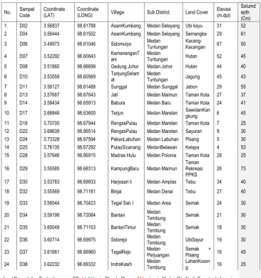
Table 1. The geographical position, elevation, land use type, spatial regions and depth of solum soil sample sites on dry land Medan
No. Sampel Code
Coordinate (LAT)
Coordinate
(LONG) Village Sub DIstrict Land Cover Elevasi (m.dpl)
Solumd epth (Cm) 1 D02 3.56837 98.61788 AsamKumbang Medan Selayang Ubi kayu 31 52 2 D04 3.56444 98.61502 AsamKumbang Medan Selayang Semangka 29 61 3 D06 3.49973 98.61046 Sidomulyo Medan Tuntungan Kacang-Kacangan 67 50 4 D07 3.52292 98.60843 KemenanganTani Medan Tuntungan Hutan 52 45 5 D08 3.51860 98.66699 Gedung Johor Medan Johor Hutan 44 40 6 D10 3.53558 98.60569 TanjungSelamat Medan Tuntungan Jagung 45 43 7 D11 3.58127 98.61488 Sunggal Medan Sunggal Jabon 29 55 8 D13 3.57687 98.67643 Jati Medan Maimun Taman Kota 27 37 9 D14 3.58434 98.65913 Babura Medan Baru Taman Kota 24 41 10 D17 3.68848 98.63600 Terjun Medan Marelan SawidanKan
gkung 6 45 11 D18 3.70700 98.67944 RengasPulau Medan Marelan Taman Kota 7 25 12 D22 3.69639 98.66514 RengasPulau Medan Marelan Sayuran 9 30 13 D24 3.73328 98.67594 PekanLabuhan Medan Labuhan Pisang 5 30 14 D25 3.76135 98.67292 PulauSicanang MedanBelawan Kelapa 4 53 15 D28 3.57646 98.66915 Madras Hulu Medan Polonia Taman Kota 28 25 16 D29 3.55585 98.68313 KampungBaru Medan Maimun
Taman Rekreasi PPKS
26 73 17 D30 3.53783 98.69933 Harjosari Ii Medan Amplas Tebu 34 40 18 D32 3.55569 98.71161 Binjai Medan Denai Tebu 27 40 19 D33 3.58544 98.70423 Tegal Sari I Medan Area Semak 24 30 20 D34 3.59198 98.72084 Bantan Medan
2nd International Conference on Tropical Biology “Ecological Restoration in Southeast Asia: Challenges, Gains, and Future Directions”, SEAMEO BIOTROP, Bogor-INDONESIA, 12-13 OCTOBER 2015
Land Degradation Evaluation as an Effort toMitigate Climate Change Mitigation in Medan City North Sumatra Indonesia 25 D39 3.62174 98.66562 KarangBeromb
ak Medan Barat Ubi kayu 18 48 26 D40 3.60089 98.65898 SeiPutih Tengah Medan Petisah Ubi kayu 22 40
Dry land in Medan who belong to a depth of solum sample location was only 5 or 19% of the sample points are observed, while the remaining 21 locations sampled, or 81% of the sample points are observed at a depth relatively shallow solum. The facts above show that although the lands in Medan no one has entered the category below the critical threshold based PP. No. 150 (2000), but the distribution of land belonging to the superficial criteria of reaching 81% of the sample locations are spread from upstream to downstream and categories were only 19%, while classified in the category (> 90 cm) no (0%) then the tendency to Further degradation reaches a critical threshold is likely to occur.
Setbacks soil depth in Medan can occur as a result of intensive erosion, especially in the upper reaches of Medan as in the district of Medan and Medan Johor Tuntungan up to the middle of the city of Medan as in MedanAmplas, Medan Selayang, Sunggal and Medan Helvetia Sub-Sistrict. While the decline of soil depth in the lower reaches of the city of Medan may occur mainly caused by compaction (compection) due to the intensity of human activity is very high as well can be caused by erosion.
Shallow Groundwater Depth
Shallow ground water is underground water (ground water or water table) that can be close to or above the soil surface. Shallow ground water appeared in regions or landscapes basin which is then referred to as wetlands. Wetland itself is defined as land that is the source of water comes from ground water (ground water) that the landscape may be in the rice fields, marshes, ponds, lakes or reservoirs, so that water could inundate or close to the ground throughout the season. While the land is the source of water comes from rainfall (only inundated during the rainy season) and the water becomes very deep soil of> 90 cm during the dry season the land belonging to the dry land.
Shallow depth of ground water in wetlands in Medan ranged between 0-6 cm. The range of the depth of shallow ground water is not entering into the critical threshold criteria based Damage Criteria Raw Land for Biomass Production (Indonesian Government Regulation No. 150 of 2000) due to the depth of the shallow ground water is still smaller (shallower) than 25 cm.
Distribution of shallow groundwater depth in Medan are evenly from the upstream area , central to the downstream area of the city of Medan . The existence region with a depth of groundwater largely (9 locations in the sample) in a state of stagnant (0 cm) and just 5 sample points that are below ground level but does not exceed 6 cm describe in the area of Medan there are potential sites for development as land the production of food crops (paddy rice), vegetables (spinach), pool/pond fish and water-based tourist areas , in addition to the development of mangrove forests, particularly in the downstream is in the district of Medan Belawan and Medan Labuhan .
Composition Fraction Land
The composition of the soil fraction is the most permanent and important characteristics of the soil in biomass production systems (agriculture, fisheries and forestry). Soil mineral particles size varies from coarse diameter of more than 2 mm until very smooth with a size of less than 2 lm. Soil particles are grouped based on the size of the particles into the rock (gravel) with a diameter of> 2 mm, sand (diameter 0.05 to 2 mm), dust
Land Degradation Evaluation as an Effort toMitigate Climate Change Mitigation in Medan City North Sumatra Indonesia (diameter (.05 to .002 mm), and clay (diameter <0.002 mm). Composition fraction of land that can only be obtained through the analysis of soil samples in labooratorium using these Hydrometer method will then determine the type of soil texture.
The composition of the soil fractions on dry land Medan, ditinjai of% fraction of sand there are on the critical threshold because it does not contain sand kuarsitik> 80%, but based on the clay content of the sample, there are about 14 points (53.85%) on dry land clay containing <18% were classified into critical thresholds based on PP. No. 150 of 2000 on Damage Criteria Raw Land for Biomass Production.
The existence of soil clay fraction consisting of clay minerals and oxides amorphous silicates are very important because the role of the clay fraction is the active ingredient making up the ground and determine the nature and capabilities in the provision of land and plant nutrient exchange. While the sand fraction and dust are largely composed of SiO2 is not much role in supplying plant nutrients, and even the presence of excess soil fraction (> 80%) describe land degradation in the form of desertification.
Sandy soil, namely the soil with sand content of> 70% causes the soil porosity to be low because most of the large-sized pore space (macro) so that good soil aeration, water conductivity fast, but the ability of soil to retain water and keep nutrients low. Excellence sand soil easily processed so as so-called soft ground.
Land with very high levels of clay fraction (> 45%) is also not good. This soil is relatively high porosity, but is mostly a small-sized pore (micro), so permeability is low and air circulation is less smooth. Clayey soil's ability to store water and nutrients are high, but the water is bound by clay strong enough, so it was difficult absorbed by plants when dry. The clay also called heavy soils because it is difficult processed.
Argillaceous soil is a land with a proportion of sand, silt, and clay such that its located between sandy and clayey soil. Such land has aeration or air and water system is quite good, the ability to store and provide water for crops is high, and the most optimum soil for plant growth. Thus, based on Table 6 it can be seen that the lands in the city of Medan that is almost entirely memili argillaceous texture (only in two locations textured clayey), so it can be said that the lands in the city of Medan has a good soil fertility levels for biomass production ,
Weight Fill Land
Soil bulk density (ρb) or bulk density is the ratio between the total mass of land in
the dry state with a volume oven undisturbed soil (soil lumps), provides an overview of the level of friability / soil density. Soil friability level is inversely proportional to the value of soil bulk density. Land with a large bulk density values describe the soil denser than the soil that has a bulk density value is smaller. In other words, the greater the value of the unit weight of the soil, the soil is getting solid and conversely the smaller the value of soil bulk density, soil more friable.
The location of the soil samples dry land in the city of Medan that the value of the unit weight of the soil into the critical threshold that is greater than 1.40 g / cm3 (according to the PP. No. 150 of 2000 on Damage Criteria Raw Land For Biomass Production) there are only The four locations, as can be seen in Table 2.
Soil Porosity
2nd International Conference on Tropical Biology “Ecological Restoration in Southeast Asia: Challenges, Gains, and Future Directions”, SEAMEO BIOTROP, Bogor-INDONESIA, 12-13 OCTOBER 2015
Land Degradation Evaluation as an Effort toMitigate Climate Change Mitigation in Medan City North Sumatra Indonesia means having adequate soil pore space for air and water movement into and out of the matrix / body ground freely.
Porosity (total pore space) in sandy soils is usually lower than the clayey soil, but the pores in the soil sandy soil pores dominated macro sized (diameter> 90 mm) making it very efficient in the pass the air and water in the soil. Micropores (diameter <30 mm) contained in sandy soils low that low water storing capacity. In contrast to the taah with a high clay content, total space is also high which is dominated by micro pores so the ability to withstand higher water, but the strength of adsorption clay and high water can inhibit the absorption of water by plants. This means land with total soil pores (pororsitas) land that is too high (> 70%) and too low (<30%) are equally poorly and are at a critical threshold by PP. No. 150 of 2000 on Damage Criteria Raw Land For Biomass Production. soil porosity value of all the locations of soil samples on dry land Medan no entry / belonging to the critical threshold according to the PP. No. 150 of 2000, due to the porosity values in the range of> 30% and <70%.
The Degree of Release of Water (Permeability) Land
The degree of release of water or soil permeability that describes the amount of water per unit of time that goes through the surface and move in the soil (cm / h) is an important indicator in conjunction with the ground water system. The dominant soil contains clay fractions will be slower to pass water in the soil mass than the dominant soil containing sand fraction. Soil with a high clay content of the dominant faction have micro pores that are less porous, which in turn would be difficult to pass water, otherwise the soil with a high content of sand fraction will easily pass the water because it has a macro pores that much. Soil permeability is too large (> 8.0 cm / hour) with the same lack of good permeability of the soil that is too small (<0.7 cm / hour) and this limit is by PP. No. 150 of 2000 as land critical threshold in terms of the degree of release of water (permeability) soil. only one soil sample point location that has the degree of release of water (permeability) that fall within the critical threshold in Medan, namely in Sub Acid Beetle district of Medan Selayang with a permeability value of 8.52. The soil permeability values exceed the criteria (> 8.0 cm / hour) as the critical threshold based PP. No. 150 of 2000 on Damage Criteria Standard Quality Land for Biomass Production.
Electrical Conductivity (EC)
Parameter electric conductivity (EC) is an indicator for lands that have high levels of dissolved salts. Naturally, soils with high levels of dissolved salts like this a lot happening in the climate of the area is very dry (arid), lands in coastal areas that are affected seawater (salt water), and can also occur due to accumulation of salts due irrigation water.
In the arid regions of dissolved salts in the subsoil can be transported to the soil surface due to evaporation are very strong. The type of soil that is formed here is saline soils, saline-sodic and sodic by varying the amount of content and comparison of types of salts.There are 7 locations of sample points that have a value that goes beyond DHL threshold specified in the PP. No. 150 of 2000 on Damage Criteria Raw Land for Biomass Production amounted to more than 4.0 mS / cm. While the value of the land DHL wetlands in Medan which exceeded the critical threshold reached 8 locations of sample points from 14 sample points wetlands locations were observed.
Land Degradation Evaluation as an Effort toMitigate Climate Change Mitigation in Medan City North Sumatra Indonesia middle Medan can be ascertained the cause comes from irrigation water contaminated by domestic and industrial wastewater, while the large dry land due to water runoff in the form of floodwaters overflowing from the drainage ditch containing domestic and industrial wastewater when it rains.
Facts on the ground indicate that many rice water coming from irrigation channels, which constitute a drainage ditch from residential areas (water is black and foul smelling) and some dry land used for the cultivation of dry land farming also has / drainage ditch alongside the people who advance shallow drainage water.
DHL high at locations downstream of the sample can be ascertained due to the runoff of the tide as it happened in the sub-district of Medan Belawan and Medan Labuhan Sub-district.
Acidity (pH) Soil
Soil acidity expressed with soil pH can be used as an indicator of fertility and degradation of soil chemistry, because it can reflect the availability of nutrients in the soil and cause poisoning micro elements and heavy metals for cultivated plants. In addition to greatly affect the availability of inorganic nutrients, low pH also affects the activity of soil microorganisms to decompose organic matter soil. pH value on all soil samples dry land in Medan no classified into critical threshold as defined in the PP. No. 150 of 2000 on Criteria Raw Biomass Production Damage To Soil with a pH ranging between <4.5 and> 8.5. Some factors that may affect the value of soil acidity in both the area of Medan them by base saturation, colloidal properties of soil, and the kinds of cations are adsorbed on soil colloids. As described earlier that DHL relatively high ground in soils existing with high salt solubility allows the pH value of the soil also be high due to the high solubility of the salt.
Number of Soil Microbes
Microbes (microorganisms) soil plays an important role in the dynamics of reactions in the soil and in support of the availability of nutrients and organic matter recycling. The main role of the microbes are as decomposers of organic matter and leaching of nutrients from the mineral soil. Thus, the presence of microorganisms in the soil become an important indicator of the quality of the soil. the amount of soil microbes in the dry land Medan no one is under the critical threshold, even much higher than the critical threshold limits as defined in the PP. Number: 150 2000 Raw Damage Criteria neighbor Land For Biomass Production of <102 cfu / g soil. The same thing happens on the ground wetland in the city of Medan. Although no one goes into the categories below a critical threshold, but there is a tendency that the lands are polluted by domestic waste or industrial waste, both on dry land and in wetlands, has a number of microbes that is smaller than the ground or slightly polluted.
Soil Erosion
The computation of soil erosion in dry land Medan using USLE get that value the highest erosion only 29.066 tons / ha / year and the value that can be tolerated erosion (erosion is allowed) ranged from 8.688 to 19.345 tonnes / ha / year. Thus the rate of erosion on dry land in the city of Medan is low to moderate.
2nd International Conference on Tropical Biology “Ecological Restoration in Southeast Asia: Challenges, Gains, and Future Directions”, SEAMEO BIOTROP, Bogor-INDONESIA, 12-13 OCTOBER 2015
Land Degradation Evaluation as an Effort toMitigate Climate Change Mitigation in Medan City North Sumatra Indonesia (24.99%), and critical only 5.15ha (0.02%). Regions with a very wide critical potential in Medan, though at this point not yet critical, but if managed in the wrong way and did follow the soil and water conservation, especially land use that does not comply with the conditions and ability to land the potential area this critical time will turn into critical areas.
Some things need to be done in maintaining the soil and land in the city of Medan in order not degraded or being critical is the way to use the land according to their ability and spatial established, multiply the tree stands, both in areas specifically designated for it, such as parks and forests the city, as well as in residential areas and along the river-banks, as well as pollution control domestic waste and industrial waste. In the coastal land (department tidal) retained important mangrove forests that sea water intrusion into inland regions can be prevented. microbes ( on dry land and wetlands ).
The rate of erosion on dry land in the city of Medan City wa is low to moderate
Alexander, M.1977. Introduction to Soil Microbiology. John Wiley & Sons. New York.
Allison, F.E. 1973. Soil Organic Matter and Its Role in Crop Production. Elsevier Sci.Publ.Co. New York.
Arsyad, S. 1979. Soil Conservation (Konservasi Tanah). Faculty of Agriculture, Bogor Agricultural University. Bogor.
Djaenuddin, dkk. 1994. Kesesuaian Lahan untuk Tanaman Pertanian dan Tanaman Kehutanan (Land Suitability for Crop Agriculture and Forestry Plant). Technical Reports 7 version 1.0 Centre for Soil and Agroclimate Research. Bogor.
Fletcher, J.R., dan R.G. Gibb. 1990. Pedoman Survai Lahan untuk Perencanaan Konservasi Tanah di Indonesia. Guidelines for Land Survey for Soil Conservation planning in Indonesia. Indonesia-New Zealand Land Resource Mapping Project. Department of Forestry. Jakarta.
Djaenuddin, et al. 1994. Land Suitability for Crop Agriculture and Forestry Plant. Technical Reports 7 version 1.0 Centre for Soil and Agroclimate Research. Bogor.
Foth, H.D. 1984. Fundamentals of Soil Science. (Translation). GadjahMada University Press. Yogyakarta.
Commented [S12]: This is just a summary of the study and not a conclusion. It also did not show the relationship of these soil properties in relation to climate change.
Commented [SD13]: Reference must include ONLY the references cited in the content. If these references were really used, then clarify each reference in the cited sentences in the content.
Commented [SD14]: There is no citation of this reference in the content of the full paper?
Commented [SD15]: There is no citation of this reference in the content of the full paper?
Commented [SD16]: There is no citation of this reference in the content of the full paper?
Commented [SD17]: There is no citation of this reference in the content of the full paper?
Commented [SD18]: There is no citation of this reference in the content of the full paper?
Commented [SD19]: There is no citation of this reference in the content of the full paper?
Land Degradation Evaluation as an Effort toMitigate Climate Change Mitigation in Medan City North Sumatra Indonesia Hardjowigeno, S. 2007. Ilmu Tanah (Soil Science). Akapress.Jakarta.
Hardjowigeno, S., dan S. Sukmana. 1995. Menentukan Tingkat Bahaya Erosi (Determining Erosion Hazard Level). Centre For SoilandAgroclimate Research. Bogor.
Iswati, A. 2006. Evaluasi degradasi tanah dan perubahan kesesuaian lahan pada kebun kelapa sawit (Studi kasus di kebun plasma kelapa sawit Pir-Trans. PTP MitraOgan Sumatera Selatan Evaluation of soil degradation and changes in land suitability in oil palm plantations (A case study on oil palm smallholdings Pir-Trans. PTP MitraOgan South Sumatra. J. Soil Tropical. 12 (1): 69-76.
Lal, R.1985. Soil erosion and its relation to productivity in tropical soil. Dalam: El-Swaify, S.A., W.C.Moldenhauer, danL.Andrew (eds). Soil Erosion and Conservation.
Lindsay, W.L. 1979. Chemical equilibria in soils. John Wiley & Sons. New York.
Peraturan Pemerintah RI. No. 150 Tahun 2000 Tentang Pengendalian Kerusakan Tanah Untuk Produksi Biomassa. Lembaran Negara Republik Indonesia Tahun 2000 Nomor 267 (Government Regulation. No. 150 2000 About onthe Soil Degradation Control For Biomass Production). State Gazette of the Republic of Indonesia Year 2000 Number 267.
Sanchez, P.A. 1976. Properties and management of soils in the tropics. John Wiley & Sons. New York.
Sarief, H.E.S. 1989. Fisika-Kimia Tanah Pertanian. Pustaka Buana. Bandung.
Tan, K.H. 1995. Principle of Soil Chemistry. Marcel Dekker. New York.
Wischmeier,W.H., dan D.D.Smith. 1978. Predicting Rainfall Erosion Loss. A Guide to Conservation Planning. USDA Agric.Handb. No.288.
Commented [SD20]: There is no citation of this reference in the content of the full paper?
Commented [SD21]: There is no citation of this reference in the content of the full paper?
Commented [SD22]: There is no citation of this reference in the content of the full paper?
Commented [SD23]: There is no citation of this reference in the content of the full paper?
Commented [SD24]: There is no citation of this reference in the content of the full paper?
Commented [SD25]: There is no citation of this reference in the content of the full paper?
Commented [SD26]: There is no citation of this reference in the content of the full paper?