USING CARDINAL DIRECTIONS IN MAP READING ACTIVITIES
TO
SUPPORTS THE DEVELOPMENT OF STUDENTS’ SPATIAL
ORIENTATION
Ermita1, Frans van Galen2, H. A. A. Van Eerde3 State University of Surabaya1, Utrecht University2, 3
1) ermitaali@gmail.com; 2) f.vangalen@uu.nl; 3) H.A.A.vanEerde@uu.nl
Abstract
Map reading activity is a good way to convey spatial information as well as to apply people’s spatial ability, particularly spatial orientation. Map reading activities may support the development of students’ spatial orientation. In order to support the development of students’ spatial orientation, in the present study we designed three lessons involving the cardinal directions in map reading activities. We considered using cardinal direction since
it is closely related to the Buginese culture. The subject of this study is 5th grade students
(10-11 years old) in SD Inpres 3/77 Arasoe, one village in South Sulawesi. The aim of this study is to contribute to a local instruction theory of spatial orientation particularly in map reading. Consequently, design research as an approach and Pendidikan Matematika Realistik Indonesia (PMRI) adapted from Realistic Mathematics Education (RME) were chosen to achieve the research aim. To conjecture what happens in the classroom, the Hypothetical Leaning Trajectory was designed consisting of starting points, mathematical goals, mathematical activities, and the hypothesis of students’ thinking. Data collections were generated from the video recording of activities during teaching and learning activities, students’ written works, pre-test and post-test, and an interview with students. The HLT was compared with the students’ actual learning trajectory during the teaching experiment in order to analyse whether the mathematical goals designed are achieved during the instructional sequence. Even though the teaching experiment was very short, we concluded that using cardinal directions in map reading activities could support the development of students’ spatial orientation.
Keywords: design research, spatial ability, spatial orientation, map reading, Realistic Mathematics Education (RME)
INTRODUCTION
map reading is important and could support students’ spatial ability. Moreover, Kurniadi stated that it is important to support children’s spatial ability by involving them in reading map activities because there is a positive relation between map understanding and spatial ability. Thus, it is crucial to involve the students in map reading activities.
To date, there are some studies in this domain in Indonesia (Kurniadi, 2013). Kurniadi investigated how the spatial ability of the students could be improved through map activities. However, the study did not make any relation between spatial orientation and four main compass directions (cardinal directions). In fact, the use of cardinal directions is closely related to Indonesian culture, particularly Bugis culture. Bugis is one of the tribes dwelling South Sulawesi which is the largest population compared with other races inhabiting in this province. The Bugis community is better known as sailors (Wasilah et al., 2010). Accordingly, Liebner (2005) assumed that the one of essential element in indigenous life is navigational practice, which is a concept of a spatial orientation. In addition, Bugis language which mostly involve cardinal directions in giving direction or describing position of an object, for instance if wanting to go to a place in north part of the village, they will say maelo’ka lokka manorang which means ) want to go to the North Liebner, 5 . This kind of culture and habitual of using cardinal directions in daily conversation could support the development of people’s spatial ability, including their spatial orientation as Boroditsky stated that language could shape one’s thought.
By considering the issues on the previous paragraphs, we decided to conduct study in this topic and derived the following research question: How can the use of cardinal directions in map reading activities support the development of students’ spatial orientation? )n supporting students, we design a learning sequence consisting of some activities in map reading. The learning sequence accommodates students to apply their spatial orientation as well as leading children to have map literacy. As a result, we expect this series of learning activities could support the development of children’s spatial orientation.
THEORETICAL FRAMEWORK
Spatial orientation is the ability to understand the localization of objects mentally relative to oneself, to one another, or to a fixed standard direction (such as a navigation system, cardinal directions, intermediate directions, etc.). This ability helps humans to have control and move efficiently in space (Freeman (1916) cited in Lord, 1941). Clements (1998) stated that spatial ability, in this case spatial orientation and mathematics achievement are related. Some studies showed that students with a good spatial orientation and spatial visualization are more mathematically competent. Therefore, spatial orientation is an essential ability which needs to get more attention from the educators, especially teachers in preschool and primary education.
between the abstract world and the real world. Students need experience in decoding to make sense of all information on maps (Lowrie & Logan, 2006). Moreover, in a study of Kurniadi (2013) it is stated that it is important to support children’s spatial ability by involving them in reading map activities since there is a positive relation between map understanding and spatial ability. Thus, it is crucial to involve students in map reading activities.
Involving children in various kinds of map activities could support their understanding of important concepts in mathematics, such as direction and location. Clements (1998) stated that children need to construct more sophisticated ideas about direction. Children are supposed to know environmental directions such as above, over, and behind, master relative directions (left, right, back, and forwards) and more global directions (cardinal directions and intermediate directions). Such ideas, combined with developing distance and measurement ideas, could be developed when children experience constructing and reading maps of the environments around them. Moreover, Clements (1998) added that another important concept in the map activities, namely location, is also a very useful concept in mathematics. Therefore, involving children in working on two-dimensional maps (navigating, map reading, and map making) could help children to grasp the idea of abstraction, generalization, and symbolization as well as important ideas in mathematics such as perspective, direction, measurement, and location (Clements, 1998).
Moreover, Pendidikan Matematika Realistik Indonesia (PMRI) which is adopted from Realistic Mathematics Education (RME) is used as an underpinning theory in this study. RME is a domain specific instructional theory in mathematics education which offers a framework for teaching mathematics and interpreting students’ activity in learning mathematics (Gravemeijer, 1994). The three lessons designed follow the five tenets of RME which are as follows (Treffers, 1987):
1. The use of context
2. Using models and symbol for progressive mathematization . Using students’ own construction
4. Interactivity 5. Intertwinement
METHOD
In this study, the researcher designed a sequence of instructional activity involving map activities to support students’ spatial orientation. Based on the aim of this study, the researcher considers that the design research is the relevant approach to be used. According to van den Akker et al. (2006), design research aims at not only for practical applications and policy implications but also the developing of empirically grounded theories of a study combining the process of learning and the means supporting the process (diSessa & Cobb, 2004; Gravemeijer, 1994, 1998).
researchers then elaborate their initial hypotheses and principles, refining, adding, and discarding through a reflection upon the design and the results (retrospective analysis). Eventually the researchers combine them together to be a coherent theory which indicate their understanding of the design experience (Edelson, 2002). Moreover, Gravemeijer and Cobb (2006) discussed the three phases of conducting a design experiment as follows: (1) preparing for the experiment; (2) the design experiment; (3) the retrospective analysis. In the first phase, the researcher studies relevant literature, constructing an initial the Hypothetical Learning Trajectory (HLT), conducting classroom observation, interviewing the teacher and lastly conducting a pre-test. Then, we conduct the design experiment consisting of two cycles of teaching experiment. However, this paper only presents the first cycle of the study and discusses mainly a lesson which focuses on the exploring the map of unfamiliar place.
The data is collected by making video registration of the teaching experiment, collecting students’ written works and interviewing students. Afterward in the retrospective analysis, the researcher analyzes the data by observing the process of teaching experiment and comparing the actual learning trajectory with the HLT.
However, it should be noted that this study is the part of a bigger design research. Therefore, the conclusion drawn in this paper is merely based on the result on the first cycle of the bigger study.
RESULT AND DISCUSSION Pre-test
Before the first lesson of the first cycle, we conduct a pre-test. Students took this test in 30 minutes and worked individually. This test purpose is to get an impression of their prior knowledge about the map reading and the concept of cardinal directions, which was important information for the implementation of the HLT. The result of the pre-test is described as follows:
1. Students had difficulties in determining the position of each cardinal directions on compass rose. They know that north and south and east and west are pairs (always put on the opposite direction). However, when north are given, they barely put the position of west and east correctly. This case was found in the four students who were subjects of the study. As a result, none of the students could answer the questions about identifying locations correctly.
2. Students had difficulties in stating as well as writing proper words or sentences in giving direction and explaining position. We presumed that students hardly found this kind of problem in their mathematics or other subjects’ classroom. As a result, students were not familiar enough with the words used in spatial orientation problems.
The Learning Activities
determine cardinal directions. The second activity which was the follow up activity of activity was to introduce the idea of determining cardinal directions by using the Sun’s position. While the last activity provided chance to students to use and read a simple map, in this case the map of their school, to find location of objects. Meanwhile in the lesson 2, students explored the map of unfamiliar place. In the lesson 3, students were required to construct mental map of the village where they live.
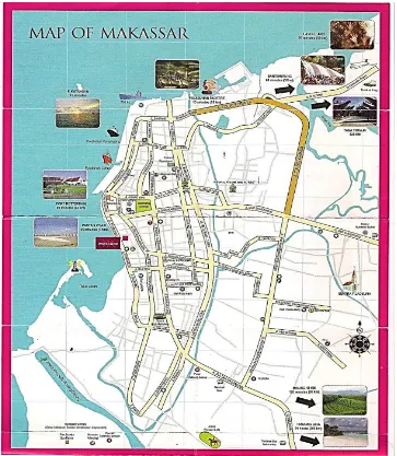
However, in this paper, we only elaborated the activities in lesson 2 in which students explored the unfamiliar map. This lesson consisted of two activities. Both activities’ purpose was to provide students chances to apply their spatial ability, particularly their spatial orientation by exploring map of an unfamiliar place, in this case map of Makassar as shown in Figure 1 below.
Figure 1: Map of Makassar
Moreover, the activities could support students to understand that symbols on map representing things in the space. Within these activities, students could identify the reference points while identifying locations. Students could get the idea that when using cardinal directions, they used other locations as their reference point while in relative system they use their body position as their reference.
Activity 1: Completing the Map of Makassar
The first activity was aimed to give a chance for students to find some locations on the map (see Figure 1). In this activity, students were assigned to find some locations of place on the map. The given instruction used both cardinal directions and relative systems. The instructions were as follows:
From Bone, you will pass Bantimurung. Go straight until you find Tol Reformasi . In the north side of the street you can see the Pelabuhan Paotere . Then you will find cross road, turn left to Jl. Yos Sudarso . Go straight to the Jl. Andalas , in your left you will see a church . In the north of the church, you will see Makam Diponegoro . Go straight until you find Masjid Agung. Then, turn left to Jl. Bulu Saraung . Go straight to Jl. Ahmad Yani , Lapangan Karebosi is in the south of the street. Go straight until you find the sea and go to the south, Jl. Ujung Pandang . In the west of the street you will see Fort Rotterdam . Continue your journey along the shore. You will see mercure in the east of the Jl. Pasar Ikan as well as Hospital and Masjid in the south of the mercure. Go straight to Jl. Gagak and turn left to the Jl. Kakatua in which a famous Coto restaurant situated. In the north of Jl. Kakatua, you will see Gelora Andi Mattalatta . Then, turn right and Hospital is in your left. Continue to go straight and after passing the cross road, in your right, you will firstly find Pasar Pabaeng-baeng then secondly a Terminal Bus . Continue your journey to the southern part of the city, after 2 hours, you will reach Malino.
While solving this problem, the students seemed following the instructions quite easily. Both group did not show any specific strategy which we conjectured in HLT, such as turning map following the directions or moving body to follow directions. Students could easily imagine when they needed to turn right or left in map as well as to follow the instructions using cardinal directions. However, one group had difficulty in identifying the exact location of places on map. The fragment below shows how the students’ struggle in identifying the exact location on map of Makassar. In this fragment, students struggled to identify the location of Church on the map see the instruction in the previous paragraph).
Fragment 1: The Location of Church
1 Student : (pointing the map You will pass the church… church. 2 Student : What if I there are no church on map, Mam?
3 Researcher : You could not find it? Then, it is your task to name it. 4 Researcher : Where is the location of church on the map?
6 Researcher : Okay, write it down.
7 Student : So, I write it here? (pointing empty space on the map near the correct location)
8 Researcher : Yeah. You should label symbols on the map. Since each symbol represents something. For example, this circle represents something (pointing the symbol of
masjid labelled as Masjid Agung )
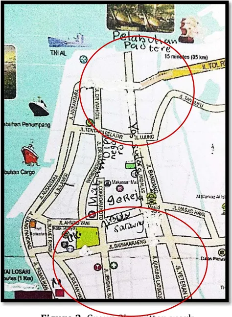
As shown in Fragment 1, the student presumably did not get the idea yet that maps are included as graph in mathematics since the symbols on maps represent things on space. Within this activity the students could understand this concept. Moreover, the following picture shows how the group of student in the fragment 1 struggled during solving the problem.
Figure 2: Group ’s written work
In the figure 2, we could see many revision done by students. Most of corrections made near the correct location. The students presumably did not know yet that in completing the map, they needed to label symbols instead of a mere random empty space on the map. Meanwhile students from another group could follow the instructions and label the symbols correctly without any obstacles.
Activity 2: Making an Itinerary for Study Tour
This activity offered students an opportunity to arrange a plan go around Makassar in a day. They need to consider the important things, such as the attraction, Musholla, place to have lunch, etc. Therefore, they needed to make sense all information on map and planned a scenario for that. In this activity, students were required to apply their spatial orientation to find the solution.
Students seemed excited while doing this problem. Both groups were involved in serious discussion of what places they wanted to visit and route they wanted to take. The following fragment shows group 1 discussion of what route they wanted to take.
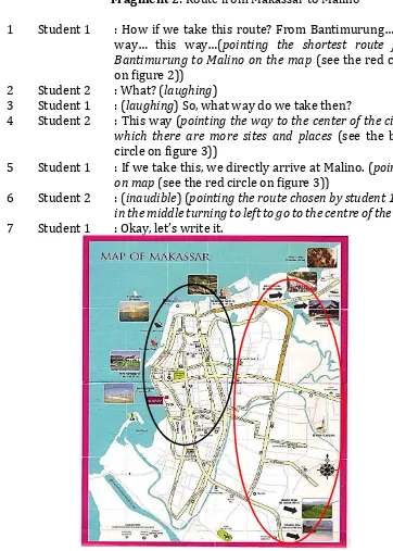
Fragment 2: Route from Makassar to Malino
1 Student 1 : (ow if we take this route? From Bantimurung… this way… this way… pointing the shortest route from Bantimurung to Malino on the map (see the red circle on figure 2))
2 Student 2 : What? (laughing)
3 Student 1 : (laughing) So, what way do we take then?
4 Student 2 : This way (pointing the way to the center of the city in which there are more sites and places (see the black circle on figure 3))
5 Student 1 : If we take this, we directly arrive at Malino. (pointing on map (see the red circle on figure 3))
6 Student 2 : (inaudible) (pointing the route chosen by student 1, but in the middle turning to left to go to the centre of the city) 7 Student 1 : Okay, let’s write it.
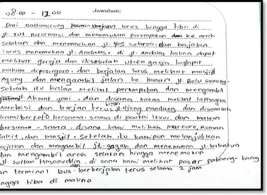
Fragment 2 shows that each student have different preference in making the itinerary. Student 1 seemed preferring the shortest distance while student 2 presumably considered the places which wanted to visit. Therefore in the end, they both decided to take shortest distance but they still could visit some interesting places in the city. However, their discussion seemed continued and the decision seemed changed. We presumed that it was due to problem language. Both students presumably found it hard to make good sentences. It was seen in their worksheet. They chose similar route as in the previous problem, but with only one place visited. The worksheet is in the following Figure 4:
Figure 4: Student’s written work
Meanwhile, the group 2 seemed having no problem with the assignment as well as the language. They chose their own route and explain the route clearly.
Based on the description above, we concluded that while doing the activity students occupied their spatial ability in general to solve the problem. Nevertheless, this kind of activity could support the development of students’ spatial orientation and map reading ability because the students were required to make a route and explain it in their own word as well as considering position of certain locations on map respecting to others’ location.
Translation:
Post-test
After the third lesson in the first cycle, we conducted a post-test. Students took this test in 30 minutes and worked individually. This test purpose is to knowing their recent development of spatial orientation after getting involved in the learning activities, instead of comparing their prior knowledge with the recent ones. The result of the post-test is described as follows:
1. Students could give directions and explain locations on map by using cardinal directions and relative system in a good sentence.
2. Students could position each cardinal direction on compass rose correctly.
3. Students could follow instructions using cardinal directions and relative systems. 4. Students could read and understand information on the maps.
CONCLUSION
Based on the retrospective analysis of this first cycle, this set of activities could support the development of students’ spatial orientation. Particularly in this lesson, these map reading activities could support students’ spatial orientation in locating and finding in objects. In general, the designed learning activities which involving cardinal directions in map reading activities could support the development of students’ spatial orientation. In addition, the teacher’s role are crucial during the activities. The teacher should be the facilitator and provide proper amount of guidance during the learning process to ensure that the students do the tasks as the intended way.
REFERENCES
Boroditsky, L. 2011. How language shapes thought. The languages we speak affect our perceptions of the world. Scientific American. Retrieved from http://
http://www.gwashingtonhs.org/ourpages/auto/2013/10/23/68598699/sci-am-2011.pdf. (Accessed on August 11, 2014)
Clarke, D. (2003). Are you functionally map literate? In Cartographic renaissance: Proceedings of the 21st International Cartographic Conference. Durban, South Africa: International Cartographic Association.
Clements, D.H. (1998). Geometric and spatial thinking of young children. National Science Foundation, Arlington, VA.
Clements, D.H. & Sarama,J. (2009). Learning and teaching early math: The learning trajectories approach. New York: Routledge.
Diezmann, C.M., & Lowrie, T. 9 . An instrument for Assessing Primary Children’s Knowledge of information Graphics in Mathematics. Assessment in Education: Principle, Policy&Practice, 16:2, 131-147.
Edelson, D.C. (2002). Design research: what we learn when we engage in design. The
Journal of the Learning Sciences, 11(1), 105–121.
Gravemeijer, K. (1994). Developing realistic mathematics education. Utrecht: CD-ß Press/Freudenthal Institute.
Gravemeijer, K., & Cobb, P. (2006). Design research from the learning design perspective. In Van den Akker, J., Gravemeijer, K., McKenney, S., & Nieveen, N (Eds.), Educational design research. London: Routledge.
Liebner, H.H. (2005). Indigenous concepts of orientation of South Sulawesian sailors. Bijdragen tot de Taal, Land-en Volkenkunde (BKI), Vol. 161-2/3, 269-317.
Lord, F.E. (1941). A Study of Spatial Orientation of Children. The Journal of Educational Research. Vol. 34, No. 34. pp 481-505.
Lowrie, T & Logan, T. (2006). Using spatial skills to interpret maps, problem solving in realistic contexts. Australian Primary Mathematics Classroom 12 (4), 14-19. Treffers, A. (1987). Three dimensions. A model of goal and theory description in
mathematics instruction – The Wiskobas Project. Dordrecht, The Netherlands:
Reidel Publishing Company.
Van den Akker, J., Gravemeijer, K., McKenney, S., & Nieveen, N. (Eds.). (2006). Educational design research. Taylor & Francis.
Wasilah, Prijotomo, J, Rachmawaty, M. (2010). Application of topophilia concepts in the architecture of the Bugis house. Retrieve from
http://www.researchgate.net/publication/259231161_Full_Paper-KALAM