MATERA CITTÀ NARRATA
PROJECT:
AN INTEGRATED GUIDE FOR MOBILE SYSTEMS
Eva Pietroni*, Stefano Borghini*, Raffaele Carlani*, Claudio Rufa**
*CNR, Institute of Technologies Applied to Cultural Heritage, Via Salaria Km 29,300, 00015 Monterotondo st.
(Rome)-
[email protected],
[email protected], [email protected]
**
Softlogic, via pasquale Revoltella 108 00152 Rome – [email protected]
KEY WORDS: Cultural landscape, multimedia guide, mobile technologies, 3D reconstructions, “augmented experience”
ABSTRACT:
Matera città Narrata is a project coordinated by CNR ITABC and financed by the Agency of Tourist Promotion of Basilicata region, aimed to the creation of a digital platform able to support the public before and during the visit of Matera (World Heritage since 1993), providing cultural contents by multiple communicative formats and access possibilities. The main components of the project are: 1) theweb site, accessible in remote and adapted also from smartphone, 2) cultural contents and applications for mobile devices (old style mobile phone, smartphone, iPad) with different operative systems.
Every user can reach cultural contents in a simple way, choosing the communicative format he prefers and supported by the technology he owns. The access is totally free for public.
In this paper we'll describe, more in detail, the application developed for iPad.
1. INTRODUCTION
Matera, a urban interpretation of the Nature
Matera is the most ancient living city in the world, an extraordinary place where the human history can be perceived in its uninterrupted continuity best than everywhere: the stable human presence in this territory began 12.000 years ago, favoured by the morphology of the environment characterized by thousands of natural caves that allowed men and women to be hosted and protected (Laureano, 1993).
The city is famous for its ancient urban centre the Sassi
neighbourhood, houses dug into the calcareous rock itself. Many of these "houses" are really only caverns, often with simple frontages built on the natural rock just to cover and protect the entrances; the streets in most parts of the Sassi are located on the rooftops of other houses.
The rupestrian habitat has been a constant of this civilization and it characterized its evolution through the centuries. Humans were able to use and adapt the natural environment to their needs and to adjust and shape their needs on the natural morphology of the territory, without disfiguring it. Today many people are still living in the same houses of their ancestors of 9,000 years ago.
At the begin of the human settlement in this area the natural aggregation of caves led to the aggregation of familiar units from which the first social agglomerates derived; in the next centuries they extended up to reach the dimension of a town. That original cell of few familiar units aggregation all around an open courtyard, living together and sharing everyday life experiences, remained a constant characteristic of this civilization, even when Matera became a town. It lasted until 1950s, when Italian government forcefully relocated most of the population of the Sassi, that was living in very bad conditions, to the new areas of the developing modern city. They were “deported” in the new quarters, built outside the Sassi
neighbourhoods and projected by famous Italian urbanists and architects (Quaroni, Piccinato, Aimonino, De Carlo, Fiorentino, Lenci). Here people started lo live in much better conditions but they lost that ancestral status based on communal life.
After a period of neglet, in 1993 Matera was “re-discovered” and Unesco declared it “World Heritage”. The restoration and the systematic re-occupation of Sassi areas started again, even if mainly (but not only) for commercial, tourist and craft activities.
The ancient town grew on an impressive canyon created by the river Gravina. The impressive landscape we can see still today in front of Sassi neighbourhoods suggests very precisely as the whole site should appear thousands years ago: a succession of natural caves and rupestrian settlements, where everything, houses, cisterns, cowsheds, folds, churches, monasteries, cemeteries, was excavated in the calcareous rock.
E.P.
2. THE PROJECT
2.1 Aimes, targets and infrastructure
Every user can reach cultural contents in a simple way, using a wi-fi free connection (whose installation, in the most attended places of Sassi neighbourhoods, is part of the project) or a telephonic connection according to his charges configuration. He can choose the communicative format he prefers and supported by the technology he owns. The access to cultural contents is totally free for public.
The main target of the project are tourists and occasional visitors. Today the visit of Matera is usually included in wider package tours (from the Adriatic and Ionic coasts) and generally people visiting this place remain just few hours or one day, an insufficient time to be able to enjoy and understand the place and its extraordinary cultural heritage. Given this situation, the final purpose of the project is to encourage tourists and families to spend a longer time in the town and in its territory through an improved cultural offer.
Matera città narrata project is much more than a descriptive traditional guide; it does not inspect monuments mentioning who made them and when. On the contrary it tells the stories that took place in those ancient sites, real fragments of life, myths, events, characters, memories, in a context where everything has never lost the continuity and the relation with the space and the time (Antinucci 2004 and 2007).
The project, coordinated by ITABC and partially realized also through the collaboration of private companies, is still in progress but close to its conclusion.
The general design of the system, the organization of cultural contents, the choice of itineraries, sites, communicative formats were prepared by an accurate and fundamental monitoring activity of tourists' preference, provenance, alphabetization and condition. This preliminary study was conducted by CNR-IRAT. The project involves many territorial public institutions: the Basilicata Region, the Superintendency for Environmental and Architectonic Heritage of Basilicata Region, the Regional Direction of Ministry for Cultural Heritage (MiBAC), the Municipality of Matera, the Park Authority, the Provincial Administration of Matera. Also other CNR Institutes were involved: ISTC, IRAT, IBAM, ITD.
From the begin a fundamental issue of the project has been the “transparency” of the technological infrastructure: solidity and stability of the system are a “must” but also facility for public to use technology and to access to cultural contents. These ones can automatically fit to personal mobile devices (technological profiling).
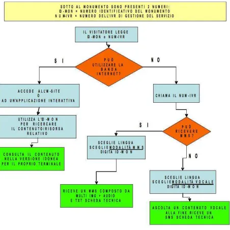
These are the access possibilities implemented by the system:
1) “Database” access while moving through the site: the visitor stops in front of a monument and finds a sign with its name and ID, together with a telephone green number. He has many possibilities. If he can connect to the internet (the place is in a wi-fi area or he uses his own charges profile) he can access to the web site and, keying in the ID, he reaches information about the monument and other related contents. He can also download a stand alone application if he owns a smartphone, in order to avoid to connect to the internet in the successive steps of the visit.
On the contrary, if he has not the internet connection, he can call the green number indicated on the sign. In this case a synthetic voice (IVR, Interactive Voice Response) will answer asking to choose the preferred language (Italian, English, German); after it will ask the monument ID and finally if the user's preference is for an audio guide (2-3 minutes) or an MMS (multimedia message, 30-40 seconds and 5 images). After this third choice the proper content will be sent.
2) “Database” access from a fixed position: the user can access the website from home, school or every other static base
and he finds directly the information about the site he is looking for.
3) “Guide” Access from a fixed position: the user can access the website from home, school or every other static base and he finds cultural contents organized in thematic itineraries; he can explore or download them in different formats as explained before (*.mp3, *.pdf, stand alone applications for smartphones) in order to use these materials while the real visit of Matera will be in progress without connecting to the web site again. Standalone applications for smartphone have been implemented in different versions for common operative systems: iOS, Android, Symbian, Windows mobile, Java.
4) “Guide” Access while moving through the site: the user is in front of the monument and he has just received the information about it. After this and in relation with this, the system will suggest what else the visitor can enjoy: thematic itineraries, witnesses, video clips with personal stories or memories told by local people related to that monument (fig.1).
Figure 1. Scheme of the system access possibilities E.P.
3. IPAD APPLICATION
3.1 Structure and cultural contents
In this paper we are going to describe more in detail the application developed for iPad by CNR ITABC (in collaboration with Softlogic), that will be available on devices that public will be able to rent in local hotels or in iTunes-Appstore for free.
We'll describe later the technical approach in the management of these media.
In the following part of the paragraph we are going to explain the main sections of the application.
Fly on the territory:
This section aims to the real time 3D exploration of the territory all around Matera. It is an “holistic” vision of the context where the user has the possibility to visualize and locate the main typologies of cultural heritage present in the area (fig. 2).
Figure 2. Ipad application: real time exploration of the territory In fact the rupestrian civilization is not only referred to the central historical neighbourhoods of the town but also to the territory of the Rupestrian Churches Park all around, including thousands of prehistorical, neolithic, medieval sites (Fonseca, 1978). The 3D reconstruction of the context is based on a GIS project, where all the data are geo-referred and integrated. The DEM was generated from topographical surveys with different resolutions: 1:10.000, 1:2.000, 1:500 (thanks to Ufficio Sassi of Matera) and its final resolution is 2 mt, to be managed with many LODs (level of details) because for the real time visualization in iPad we need to limit the calculation to 20-25.000 polygons. The 3D geometry, divided in many tiles according to the level of detail adopted, was mapped with Quickbird satellite photos (80 cm resolution), and with an IGM map where it is easier lo locate and identify all the topographical themes. The virtual exploration is controlled by a very particular third person camera: moving and tiping the iPad the user must guide a Lesser Kestrel (a typical little hawk living of Basilicata) flying all over the territory; it can lose or gain altitude and speed, turn left and right acting the proper animations. Even if the user decides the direction to apply to his movement, the bird keeps a certain degree of autonomy. The camera has not a rigid constrain and a fixed distance from the avatar-hawk but a flexible behaviour and this solution produces a very nice effect.
The user can modify the textures of the territory choosing the map or the satellite image, he can also visualize some thematic layers, as 3D icons located on the landscape: prehistorical sites, rupestrian churches, shepherd's settlements, manor farms, new urban quarters, towns near Matera and so on. Some of these company) that we propose in another section of the application.
Guide:
As mentioned before our goal wasn't to create a guide following the traditional descriptive approach of monuments and sites. The places we meet are occasions to tell stories, fragments of real life, memories, events, legends, through the voices of characters lived in different times – counts, knights, saints, governors, chroniclers, historians, archaeologists, artists, farmers, abbesses - and following a progression where many cultures and building techniques meet and cross each other. Each place/story is told through a slide-show and an audio comment, a not heavy format in terms of resources but efficacious from a communicative point of view (if the user is in front of the real place he doesn't need an oversized multimedia format). The sites can be accessed directly from a map or following thematic itineraries (there are four, two in the Sassi
neighbourhood, one up to the Civita and one in the territory outside Matera, along the Gravina).
The passing of the time:
The section is dedicated to the evolution of the landscape and of the urban context of Matera through the time. This evolution process is described and shown through video clips based on 3D rendering showing the context in eight different ages: the emersion of lands from the sea more than two million years ago, the terrain and “gravina” formation, the birth of the first neolithic entrenched settlements (5000-4000 b.C.), the diffusion of the life in the caves, the construction of the “built” and fortified space in the Middle Ages, the expansion from the
Civitas to Sassi suburbs, from Sassi to the planar area where the modern and contemporary city developed (Gattini, 1882; Volpe, 1818; Fonseca, Demetrio, Guadagno, 1999; Demetrio, 2009). The 3D rendering are supported and combined with historical documentation, iconography, literary citations; a critical info-graphic apparatus was also elaborated in order to highlight, on the actual images of the town, the interpretation process followed and the correspondences between the 3D reconstructions of the past and what is still visible today.
Views through the time:
The 3D reconstructions of the past chronological phases have been used in this section in order to create an experience of “augmented reality” (Gibson, J., 1979; Forte, 2008; Cameron, F. & Kenderdine, S., 2007).
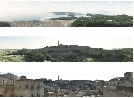
The views through the time, in fact, are views on the urban and/or natural urban landscape that can be observed in their process of historical evolution and transformation. Six main views (indicated on the map with orange icons) are panoramas in 3D reconstructed in eight chronological phases, from 2 million years ago until today. In each of them the actual image and the 3D reconstructions of the past are perfectly overlapping and it is possible to perceive and understand the whole chronological progression. A cursor allows to modify the transparency of the levels in order to have more possibilities of comparisons and analysis (fig. 3a - 3b).
Other views consist in historical images taken inside the Sassi
Figure 3a – 3b: . Interactive panorama, view of Matera from the “Belvedere della Murgia”: the first image refers to the end of the IXX century, the second one to the Neolithic age (5000-4000 B.C.).
Figure 4. The interactive map with the views through the time
indicated with orange and blue icons.
Figure 5. Historical photos taken from the same point of view, showing people living inside the Sassi neighbourhoods before
1950s and the same place after the depopulation.
Witnesses:
Many people living in Matera supported our project: they described places and events in the light of their memories, encounters, visions, works, life experiences. The space become place: a new identity emerges, a new “speaking” portrait of the town, after that one, very famous, by Carlo Levi, "Lucania 1961", today preserved in the National Museum of Medieval and Modern Art in Palazzo Lanfranchi. In our application these witnesses are fixed in video clips, each one two- three minutes long.
E.P.
3.2 Problems of historical method: reconstructing the stages of a urban evolution.
The reconstruction of the geological and urban history of Matera site, carried out directly by ITABC-CNR, has been one of the most important steps. In fact one of the main feature of the town has been its capacity to change and to rebuilt itself over the time, which is a rarity in the occidental cities; Matera has a very original urban history, not comparable with the ones of other urban realities. It is characterized by urban growth features that make it a carved and modeled rather than a built town. So, we focused on the idea of morphing: Matera is made by a material, first sculpted by nature and than moulded by man, constantly evolving itself. To handle this difficult subject, we thought to reconstruct the different stages of the history of Matera site, since the geological periods of Pliocene and Pleistocene, throughout the Neolithic age and the pre-urban stage of fifth century B.C., until the urban development in medieval and Renaissance and late-nineteenth-century periods. Each of these stages required a 3D model of the town and of the landscape all around. The 3D reconstruction of the context enables to appreciate the town in a wide visual field. Our goal was to give the idea of Matera as a unitary object and not as a combination of different particles. We wanted to represent the town as a unique body, evolving stage by stage (fig. 6).
peculiar features of Matera themselves make the task of an accurate historical reconstruction a very difficult job. First because, at least until XVIII century, the sources are very limited; then because we have to forget a town with a well-defined center of the city and with a linear horizontal urban growth. Matera instead is made by urban areas continuously changing and growing along both a vertical and a horizontal direction, following an idea of urban transformation involving all the city itself for each historical stage. It is easy to understand as the historical and research issues as well as the source investigations are very difficult and hard in this case. Moreover, a serious and scientific work in medieval archaeology about the city (and about its defense wall, for example ) has just begun. So it has been necessary to trust often to typological consideration or, in some cases, to trust to ideas of historical coherence and plausibility. This condition led us toward a system of scientific information about model validation, based not only on the specific bibliography referred to Matera, but also on generic studies about urban and architectural issues in Southern Italy.
Figure 6. The development of urban historical phases. Below we are going to expose the main research lines and the most important matters in hand.
As regards geological studies, we attempted to investigate the geomorphological evolution that brought to the appearance of Matera's "calcarenite" (the particular kind of soft and malleable sandstone in which Matera has been excavated). So we attempted to reconstruct the terrain form, understanding the transformations of the shore lines. These huge modifications turned an ancient Pliocenic island, belonging to a wide ancient archipelago, into the Murge plateau characterized by a relevant river erosion. This is the reason of the origin of the ravines, spread on the territory. Such research has been conducted mainly using the studies by Tropeano (Tropeano 2003), as well as other surveys of ancient climate and flora. Furthermore we have studied the geological map of Matera, paying attention in particular to identify the ancient fault lines.
As regards Neolithic period we referred to the old studies by Domenico Ridola, made between the end of the XIX and the begin of the XX century. However this kind of research was handled without any scientific methodology, and so, unfortunately, it was mostly lack in reliability. On the other hand, the classical period of IV century B.C. is made according to the latest literature. For this historical stage, we imagine not
yet a urban center, but many little built-up areas with scattered house of greek appearance, built with adobe walls and roof tiles. The urban history of Matera was handled organically only few times. The first time was in 1981 (Rota - Conese - Tommaselli 1981), when several bi-dimensional reconstructions of Matera site was attempted. In 1990 a second edition of this book was published, where the plans were revised and corrected. Then, in 1999, Cosimo Damiano Fonseca, a noted scholar in Basilicata's medieval history, with Demetrio and Guadagno, gave a new version of these urban interpretations (Fonseca - Demetrio - Guadagno 1999). Finally Rosalba Demetrio published in 2009 a new study with a rich archival research of historical characters concerning most of all the Medieval phases of the city (Demetrio 2009). There is a reconstruction plan of the city in this book, too. So we have used these researches to reconstruct two Medieval stages (a Norman and a Swabian-Anjou periods), a Renaissance and a Late-nineteenth-century's ages.
Despite those research, many issues regarding the urban reconstruction are still unresolved. So we have forced us to personally study this question, giving some new interpretation and new hypothesis. This is not the place to explore these issues, but I want only mention the most important ones. A very relevant consideration regard the city walls. We know Matera had city walls already during Norman age, but there are not any clear sign of the ancient walls path (only little part of it and old towers). So there are a lot of interpretations, often not in according themselves. We have made a choice to follow the information coming out from an interesting ancient plan of the city (from 1584) in which the city walls are represented. And we used this source as reference point for reconstructions of each phases (fig. 7).
Figure 7. An ancient city plan of Matera, 1584.
Another critical point in the historical development of Matera is the obscure building known as Castelvecchio. This name is perhaps the historical memory of the Norman castle that the citizen completely razed to the ground in order to build over it several Renaissance mansions. So we haven't any idea of the typology of the castle, and we don't know actually if it is possible to imagine a castle itself.
reconstruction of Castelvecchio is still hypothetical, but supported by philological thought.
In order to let the final user understand the level of the hypothesis concerning the 3D images presented in the different phases, the reconstructions of each historical stage will be accompanied by a short video clip. It will show the sources that supported the 3D reconstructions, the drawings and the main historical references. The info-graphics design is used to emphasize some specific aspects of drawings, graphs or photos (fig. 8) that find correspondences in the 3d reconstruction.
Figure 8. An info-graphics image about city walls.
S.B.
3.3 Modelling techniques
The 3D reconstruction of Matera in its several chronological phases has been made using various modelling techniques. The whole process has been split in two main parts: the modelling of the anthropic ecosystem and the drawing of the natural one. The anthropic ecosystem concerns the urban features of the city, and it regards buildings, streets, squares and so on. The first historical phase we modelled is the end of the XIX century, because it is the nearest to the nowadays situation and it shares many elements with the present time. Once such model was been built, the others historical phases have been subsequently obtained, going back in time, according to the indications provided by the historical and philological research.
The technical documentation used as base has been provided by the Ufficio Sassi of Matera and it consists in many CAD files representing the urban plans of the historical centre (Rioni
Sassi). These files have different representation scales and all the elements held inside have the dimensional and geographical references, including the elevation attribute. So we have been able to model with precision all the urban parts.
Considering the complexity and the dimension of the city, we had to use a low poly technique to build the whole model. Following this method, we obtained the general reconstruction of volumes forming the historical centre. These polygonal items have been “dressed” with texture provided by the manipulation of the pictures taken during many photographic campaigns. At this point, the mesh representing the land of Matera’s area, has been merged, before adding other elements of natural ecosystem. For all these stages of the process, Autodesk 3ds Max 2010 has been used as modelling and texturing tool. The
geometry of the land has been created using a DEM, drawn according to the topographical surveys processed into Geographic Resources Analysis Support System application (GRASS).
All the models created, have been exported in E-On Vue Xstream, an ecosystem builder software. Here we have planned and drawn all the shaders, representing the natural materials. To generate them, we used a procedural algorithms which is based on nodes architecture: putting together several functions, laid on a tree structure, it has been possible to define the behaviour of the materials according to the dimensional and morphological features of the items to which they are applied.
To simulate the vegetation we identified a list of tree essences, sorted by quality and quantity criteria. All the data used to simulate the vegetation aspect are based on paleobotanic and botanic studies. At this point, we “mapped” the land geometry with a texture indicating to the software where and how many trees and plants have to be drawn. Using the proxy instances method, we were able to render a huge amount of polygons and so to obtain a plausible result.
The renders have been processed in Vue where it was possible to define also the atmospheric effects. In this way the images produced have an abstract and metaphysical style. We achieved this goal in order to avoid an extreme realism, in consideration of the hypothetical degree of the reconstructions.
R.C.
3.4 Technical specifics
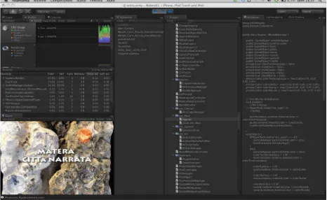
For this iPad application we used Unity 3D for iOS as developer platform (fig. 9). The main reasons that led us to this choice are: the short development time consuming in relation with the complexity of the application, the strength and stability of the engine and its well written documentation. In the meanwhile we needed to accept a little lack of performances due to the use of high level scripting language, as it happens for every 3D engine. In our case this was irrelevant.
Figure 9. Unity framework
We have subdivided the digital contents in about one hundred small contexts, called "scenes" in the Unity 3D framework in order to manage the huge quantity of data (real time 3D, video clips, GUI, slide-shows, sounds and so on). The Unity framework , in fact, cleans out the memory in the scene loading procedure.
1) 2D textures: in order to use the PVRTC compression (standard compression format for iPad) we created only square textures, from 16x16 up to 2048 x 2048 pixel. In some cases we generated textures "atlas" including in one image many smaller sub-images.
For real time 3D objects we used self-illuminated rather then diffuse light shaders, lighter in the frame calculation.
2) real time 3D objects: we imported static and animated 3D models from 3DMax in *.fbx format , the maximum allowed amount of triangles is 20-25.000. At the begin of the application, in order to suggest the concept of Matera as a sculpted town in the rock, we created series of real time morphing animations between more couples of meshes with the same number of vertices (the original rock, the plug incision and cut, until the opened cave); these transformations are obtained moving all the vertices from one position to another and interpolating them through the time.
3) GUI : we created a customized GUI rather than standard iOS one, in order to obtain a more artistic impact. In the real time scene " Fly on the territory" we made a "head-up display" (HUD) showing additional information like the position in the territory, the flight altitude and some help messages.
4) Video clips: the application includes twelve video clips in local (2'-3' long) and a larger number of video clips accessible in remote streaming through and internet connection. The format is *.mov * .H.264 with a data rate of 1,5 mb/sec. 6) Audio contents: the audio format is *.mp3, from 128 to 256 kb/sec. To avoid the redundancy of musical comment during the long time of the fruition we have created a "sound machine" combining sounds randomly or in a predefined sequence. The result is always different. Sounds are created and mixed using SuperCollider and Pro Tools.
7) Input: we employed iOS gestures like touch, pinch, swipe, and so on. To control the flight of the hawk, as described above, we used the iPad "accelerometer". We didn't need to integrate the GPS in the application because the iOS multitasking functions allow to use the integrated standard tools ("Maps") to find and update constantly the user's position.
For all the behaviours related with logic and navigation through the scenes we used mainly C#; some scripts are written also in Javascript.
The target of this application was the iPad first generation. C.R.
REFERENCES
References from Books:
Antinucci, F., 2004. Comunicare nel Museo, Laterza,. Antinucci, F., 2007. Musei Virtuali, Laterza, Bari
Cameron, F. & Kenderdine, S., 2007. Theorizing Digital Cultural Heritage: a critical discourse, Mit Press.
Demetrio R., 2009. Matera. Forma etImago urbis, Laterza, Bari.
Fonseca C.D. - Demetrio R., - Guadagno G., 1999. Matera, Laterza, Bari .
Fonseca C.D., 1978. Habitat – Strutture – Territorio, Galatina. Gattini G., 1882. Note storiche sulla città di Matera, Stab. Tip. Perotti, Napoli.
Gibson, J., 1979. The Ecological Approach to Visual Perception, Lawrence Erlbaum Associates. Hillsdale NJ.
Forte, M. et al., 2008. La Villa di Livia, un percorso di archeologia virtuale, Erma di Bretschneider, Roma. Laureano P., 1993 Giardini di pietra: i Sassi di matera e la civiltà mediterranea, Bollati Beringhieri, Torino.
Levita M., 2008 Il castello di Melfi. Storia e architettura, Mario Adda Editore, Bari.
Tropeano M., 2003. Il Parco Archeologico, Storico, Naturale delle Chiese Rupestri del Materano, in “Geologia dell'Ambiente” Suppl 1/2003.
Rota L. - Conese F., - Tommaselli M., 1981 (1990).
Matera:storia di una città, BMG, Matera.
Volpe F.P., 1818. Memorie storiche profane e religiose sulla città di Matera, Stamperia Simoniaca, Napoli.
References from Other Literature:
Forte, M., Pescarin, S.& Pietroni, E., 2006.Transparency, interaction, communication and open source in Virtual
Archaeology. In Proceedings From space to place, II International Conference on Remote Sensing in Archaeology (pp. 535-539), BAR, Roma.
Acknowledgements and Appendix (optional)