Abstract
This dissertation is an analysis of the role and importance of a pedestrian in an Urban Indian city. The primary analysis of this dissertation has been limited to Delhi due to constraints of time. It is to be noted that
conclusions drawn for Delhi may not be true for another city.
Delhi is a large city. Since it followed a model of suburban sprawl in its planning, the majority of work and residential areas in the city are
segregated. Thus, a pedestrian is often required to travel large distances on a daily basis. Such a scenario requires an efficient public transport network, with comfortable last mile connectivity. Being the capital city of India, the city is not without the resources to provide the same but the residents of the city seem to opt instead for private means of transport, as suggested by the high levels of car ownership in the city. This has led to high air and sound pollution levels in the city. The dissertation studies the factors that goes into making a good pedestrian environment and
highlights the problems that hinder pedestrians in the city. The inferences were arrived at through case studies of Kashmere Gate ISBT, SPA
Architecture Block, Kailash Colony and India Gate.
User surveys were taken which were then cross checked through visual surveys. The data served as an empirical base for the conclusions. The main hindrance to pedestrian movement is the lack of security and safety. Blockage of pedestrian paths by vehicles and shops is another factor.
Key Words
:
walking, comfort, security
Declaration
The research work embodied in this dissertation titled ‘The
Urban Pedestrian’ has been carried out by the undersigned as
part of undergraduate programme in the Department of
Architecture, School of Planning and Architecture, New Delhi,
under the supervision of Ar. Arpita Dayal.
The undersigned hereby declares that this is his/her original
work and has not been plagiarised in part or full form from any
source.
Shijo Antony Jose
A/2371/2011
12 November 2014
Acknowledgement
…I wish to offer my sincerest thanks to my dissertation guide
Ar. Arpita Dayal who has been a guiding hand throughout the
process of making this dissertation. She has given me several
of her working hours and I’m thankful for them.
I also wish to thank Dr. Jaya Kumar, Dr. S Manchanda, Ar. P
Sugga and Dr. Leon Morenas for their helpful comments on
each of my stage submissions which helped me in the
rectification of mistakes and made this dissertation look like
one.
Finally, I would like to thank my friends and family for their
support and for helping me in conducting and compiling user
surveys. You’re the best.
Table of Contents
1.3: Methodology of analysis 1.4: Limitations
Chapter 2:
Usage and Activity Pattern
…
14
2.1: The Modern Day 2.2: Congestion
2.3: Street as a Space
Chapter 3:
Richness of Experience
…
19
3.1: Re imagination
3.2: Restriction and Accessibility 3.3: Urban Vitality
Chapter 4:
Sustenance
…
28
4.1: Cycling 4.2: Upkeep
4.3: Public Participation 4.4: Landscaping
Chapter 5:
Case Studies
…
33
Secondary Kashmere Gate ISBT … 34
Primary Architecture Block, SPA Delhi … 39
Kailash Colony … 45
India Gate … 49
Chapter 6: Conclusions
…
53
Chapter 7:
Appendix
…
54
7.1: References 7.2: Questionnaire
List of Figures
Cover Fig: Ashram Chowk; Source: Author
Fig 2: Cycle Ban in Kolkata; Source:
www.downtoearth.org.in/dte/userfiles/images/20130731_20.jpg
Fig 3: Street Section of Delhi; Source: Guy Davis
Fig 4: Nanjing Road Shanghai; Source: http://www.gardenvisit.com/blog/wp- content/uploads/2010/04/shared-space-landscape-design-nanjing-street-shanghai.jpg
Fig 5: Stroget; Source:
http://1.bp.blogspot.com/- u7msphfYfPY/Tj8eAWuCkaI/AAAAAAAAHXk/dA1WQZSIk-o/s1600/stroget.jpg
Fig 6: Parking Rate Demographics;
Source: urbandemographics.blogspot.in/2011/07/parking-rates-worldwide.html
Fig 7: Informal Bus Stop; Source: Author Fig 8: Eyes on the Street;
Source: https://courses.cit.cornell.edu/arch262/notes/images/site-security-14.jpg
Fig 9: Pedestrian path, Moolchand Flyover; Source: Author
Fig 10: London Cycling Campaign; Source:
s3.amazonaws.com/lcc_production_bucket/files/4116/in_content.JPG? 1320343689
Fig 11: Street Transformation; Source: http://www.deconcrete.org/wp- content/uploads/2011/05/Ciclopaseo-in-Quito_Cycling-Citizenship-in-the\City_Ximena-Ganchala.jpg
Fig 12: Map of Kashmere Gate ISBT; Source: here.com
Fig 13: Architecture Block; Source: spa.ac.in Fig 14: Map of Archi Bock; Source: here.com
Fig 15: Kailash Colony Metro Station; Source: en.wikipedia.org Fig 16: Map of Kailash colony; Source: here.com
Fig 17: India Gate; Source: Author
Fig 18: Map of India Gate; Source: here.com
List of Tables
Table 1: Bus Operation; Source: Thesis Report on Planning of Pedestrian Friendly Design in Transit Areas by Ganguly, S., 2009
Table 2: Adjacent Roads; Source: Thesis Report on Planning of Pedestrian Friendly Design in Transit Areas by Ganguly, S., 2009
Table 3; Passenger Distribution; Source: Thesis Report on Planning of Pedestrian Friendly Design in Transit Areas by Ganguly, S., 2009
Table 4: Adjacent Roads; Source: Author
Chapter 1:
Introduction
Delhi has grown by leaps and bounds in terms of development and
infrastructure. It is among the largest cities in the world and is also home to large urban populations. Porosity is a major guiding factor in the design of public spaces and provide character to an area. The experience of a space can be severely affected by the ways its edges are treated, i.e. by controlling how a person enters/exits the space Careful design increases the aesthetic quality and the standards of safety and quality of living in a city. Delhi has seen large scale transport infrastructure developments like the metro rail and the world's largest CNG bus network. Yet, what was once the thriving pedestrian city of Shajahanabad is now called the ‘Car Capital’, with the highest levels of Car ownership in the country. (TERI, 2006). Till August 31 this year, 619 pedestrians have died on Delhi's roads. This is over 46 per cent of those killed in fatal accidents last year. This leads one to question the effectiveness of the public transportation
infrastructure in the city. Why are there so many cars? Is it difficult to be a pedestrian on the streets of our Capital city? This begs for a critically analysis of the infrastructures available to pedestrians in the city. Through this dissertation, I seek to develop an understanding of the status and importance of the pedestrian in the present day Indian scenario.
Aims
To develop an understanding of the status and importance of the pedestrian in modern Delhi.
Objectives
To understand the concept of pedestrian friendliness in an urban
context.
Scope
Delhi as an urban city provides a base for the collection of empirical
data
Since the study deals with modern day problems of traffic
segregation, it will focus on high footfall areas.
Limitations
The analysis of case studies will rely on opinion surveys of the
present day users which may not reflect earlier scenarios. Also, varions depending on their social background and may thus affect the analysis.
Different cities have different patterns with respect to their social and street patterns. Observations and conclusions for Delhi may not be valid for other cities.
Utilization of pedestrian space may have seasonal variations which
is difficult to map in the time frame of the research.
Methodology
Understand the concept of
pedestrian friendliness – What
constitutes a pedestrian friendly
environment?
High footfall areas will be identified
Secondary sources will be used to
study the area and to map pedestrian
infrastructure in the area.
Primary Case Studies
Secondary Case Studies
User surveys will be taken to
assess people’s perceptions
regarding pedestrian
movement
Visual surveys to verify
Results will be analysed to learn the
effectiveness of pedestrian
Chapter 2:
Usage and Activity Pattern
A mapping of spaces and the people who use them – their activities and movement with respect to time and space
The Modern day
Early morning, the Rooster crows everyone awake with the sun rise. Sadly, for me and most others living in a metropolis, this is only a romantic ideal. Vehicles have become the de facto means of transportation in Delhi and have even become to be acknowledged as a basic necessity. It has
become a trend for households to buy multiple cars. Delhi had 7.2 million registered cars as of 2011 TERI projects a rise of 45–60 million cars on our roads by 2025 and in some cities more than 300 cars per 1,000 people. Though this is still lower than car ownership rates in more developed nations, it is a severe problem due to the considerably higher population densities and thus the higher car densities in Indian cities. (City Mayor Statistics, 2007) and calls for an even greater need for the encouragement of pedestrian movement.
The presence of so many cars on the road results in mile long traffic pile ups even on the expressways, the cars slandering to a snail’s pace, all the while churning out their fumes into the city air. The ‘Car Capital’ has alarming levels of air pollution. Air pollution can be measured in terms of the PM 2.5 levels, a measurement of very small airborne pollutant
particles capable of penetrating deep into the lungs. As per the WHO, a safe level of PM 2.5 is 25. But according to The Centre for Science and Environment, a Delhi-based environmental advocacy group, during winter of 2013, Delhi’s average daily PM 2.5 level was 240 and even crossed the
500 mark 8 times during the first 2 weeks of 2014. And in 2013 study found air pollution to be the fifth largest killer in India, causing more than 600,000 premature deaths — up six times from 2000. This is in stark contrast to Paris, where alarm bells sounded as soon as the city breached the 180 mark on the 11th of March 2014, enforcing car restrictions and provision of free cycle services to contain pollution levels. Pollution levels were down to 25 within a week. (Bowmik, N., 2014) Indian cities are in dire need of similar policies. However, in the absence of proper architectural planning, policies like the implementation of the BRT system in Delhi backfired while Kolkata came up with the bizarre strategy of banning cycles and
makes the decision even more ludicrous is that it is the only major Indian city where the number of bicycle rides outnumber that of car trips, with commuters making more than 25 lakh trips daily. (Tandon, R., 2013)
Congestion
Generally, congestion in a city happens in high density areas, which tends to be in its core – the most ancient part of the city which has evolved over
the years to form the modern day metropolis. Being the core, there tends to be a lot of movement to and through it. Thus, roads originally meant for animal and pedestrian movement increasingly come to be used for
vehicular access and parking until traffic bottlenecks occur, whereby the roads are widened as necessary or by building by passes, thereby
transforming the urban character from the predominantly pedestrian pace to the brash and larger scale requirements of vehicles (Choudhury, A, 1989). This will ultimately result in serious implications for energy security, equitable allocation of road space, air and water pollution, road safety and will also accentuate problems related to parking and congestion, which many of our cities have already started witnessing. (Ghate, A. T., Sundar S., 2014). This raises the question – of whether vehicles should be allowed to ply on Indian roads. The preservation of areas is essential for the
retainment of the urban character of a city.
In September 2014, the Hindustan Times, in association with panel of experts*, compiled an agenda titled ’10 ways to Unclog Delhi’, which proposed to improve the city’s choked veins and arteries that make commuting in the city an agonizing ordeal. They came up with the following guidelines:
Better Transit: Delhi’s bus service is unreliable. Currently there are less than 6,500 buses plying but there is a need for 15,000. Taxis are few and autos overcharge.
Improve Last Mile Connectivity: The existing feeder service is inadequate and unreliable. Cycle rental should be promoted.
Curb Illegal Parking: Multi level car parks required. Parking rates should be area specific and based on market demand. Priced
parking can reduce car use by 10-30% if linked with transportation choices, encouraging people to take use public transportation, walking and cycling.
Act Against Traffic Violators: Currently, driving licences are easy to get. Tests should be made stringent and steep penalties should be imposed for violations.
Discourage Private Vehicles: High parking charges and congestion charges should be introduced to discourage use of cars. Levy taxes on second vehicles and make personal parking mandatory for anyone buying a car.
Free Up Roads, Remove Encroachment: Most shopkeepers and street vendors encroach on footpaths, forcing pedestrians to walk on
roads. Civic authorities should coordinate with police to identify such instances and free footpaths of encroachments.
Encourage Pedal Power: Almost 60% daily trips less than 6km can be done on bicycles but lack of dedicated tracks is an impudent. There’s a need to develop congested areas exclusively for
pedestrians and cyclists, build cycle tracks and promote cycle sharing.
*Former DDA commissioner AK Jain, advisor to Centre for Science and
Environment and former UTTIPEC director Ashok Bhattacharjee, HOD of Transport Planning Dept. at School of Planning and Architecture PK Sarkar, associate
professor at SPA Dr Sewa Ram, ITDP director Nalin Sinha and principal scientist with Central Road Research Institute Dr K Ravinder.
The Street as a Space
Let’s delve into the 'street' as more than a medium for travel and rather as an urban space to be experienced. Streets have always been an important part of settlements. Traditionally, streets served as a hub of activity and as a space for human interaction. They served as a
marketplace, a meeting place, a waiting place, community space, a social space and even as a playground for children. It also served as a
need for long distance travel. The streets came to be seen merely as a transit zone rather than a place for human interaction. This in turn has resulted in the transformation of streets into vehicle oriented roads. Streets, like any other aspect of culture, reflect the process of adaptation of culture to environment. India in particular has a lot of traditional culture associated with streets. We need to recognize that modern methods of urban planning and design that arose with the modern movement are plagued with the same problems as modern architecture. They take on a function oriented approach, blissfully ignoring the user as a living
breathing being and viewing streets as little more than a corridor for the flow of traffic. Streets are a very integral part of urban environment. The essence of street life is reflective of the urban character of the area. An active street goes a long way in bringing life and liveliness to an area, and attracting the public to come out on to it for what it offers. (Ajay Kala, cited in Vats, N, 1992)
Our urban streets should not be seen as mere arteries for transport. That will ultimately lead to deterioration. Chandini Chowk was once considered a social paradise. During its prime, it was a carefully planned residential and 'baazar' areas with a central water channel and velvet grassy lawns with flower gardens. It was also home to
one of the largest flower markets in the region. The area was planned out with a wide procession path, with residences on both sides. However, today, it is a
paradise unkempt. After the arrival of the British, the area was overlooked and soon fell into disrepair. (Goel, V) This was
accentuated during the construction of Lutyen's Delhi, when a lot of workers migrated into Delhi to feed the massive labour requirements. After construction, many of the 29,000 labourers settled down in Old Delhi. This, along with the
18
rising population lead to public spaces being encroached upon and led to densification, the broad streets of earlier now limited to narrow arteries, jostling for space and often clogged with traffic. Thankfully, Old Delhi is set for a revival. Delhi Development Authority has laid out redevelopment plans that include the pedestrianization of the whole area and promotion of non-motorized transportation. It will be the 4th pedestrian reserved area in India after Fazilka city in Punjab, Matheran and the Mall Road in Shimla. (Wikipedia) It will also be the first pedestrian zone in an Indian metropolis, thereby laying the foundation for more such. It has already inspired a proposal for the Gateway of India stretch. (Khergamker, G, 2014)
Chapter 3:
Richness of Experience
Richness of experience depends upon the environment and the pedestrian perception of this environment. Urban environments basically consist of 2 parts - built form and open space. Richness of built environment is a combination of an appreciable level of detail, variety and aesthetic
than a drab one. Aesthetic appeal of open spaces lie in the quality of the built envelope and the enriching elements within, as in the Piazza di San Marco. Intricately designed elements like street lamps, benches and
fountain can add a lot to visual pleasure while also serving their utilitarian functions. A pedestrian's perception of a place can be treated a series of snapshots. A rich experience makes a space memorable. (Dar, J, 1994)
Buildings which fascinate and catch the public imagination and that people find worthy of reflection are usually the ones that are less predictable and more dynamic. We live in a changing world. Buildings change with time. So do the notions of beauty because society,
individuals, speed, duty, morals, and culture change.
What looks good to one generation doesn’t look well to another. Every historical period has its best buildings with distinguishing qualities. Such buildings surprise you and at the same time stimulate your imagination. What is the feature then that makes them so unique and quite different? It
should be an idea,
readable by everyone or almost everyone (Kiroff, 2002).
Forster (1999) asserts: “Any claims we make for buildings that fascinate us and that we find worthy of reflection prove hard to substantiate when our audience has little or no knowledge of the subject or does not incline to our point of view”.
Re-Imagination
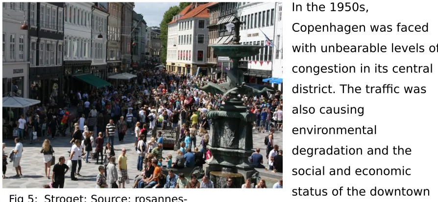
20 Fig 4: Nanjing Road Shanghai;
In the 1950s,
Copenhagen was faced with unbearable levels of congestion in its central district. The traffic was also causing
environmental
degradation and the social and economic status of the downtown area was at risk. The narrow streets in the city's historic core simply couldn't handle the increasing number of private automobiles. The solution arrived at was 'Stroget' – a central pedestrian zone (in Danish, 'stroget' means 'to stroll'). As soon as it was introduced in 1964, it transformed the identity of
Copenhagen. The whole pedestrian district now benefits from the narrow street pattern, with the unexpected alleyways and arcades providing a variety in scale, thereby making pedestrian passage livelier. Today, it has expanded, with more streets being pedestrianized across the city, forming a spiral web pattern with plazas and open spaces at many of the
intersections. These serve as spaces to relax, usually highlighted by sculptures or historic landmarks and provided with seating. Regardless of the scale and general monotony of the modern metropolis, there is always need for public spaces for human interaction, where a person can find himself in scale with his surroundings. The Stroget has brought this to light. Its plan and ambience draws people in, intriguing them across its length. Small boutiques, crafts and clothing shops have thrived, and also serves as the centre of the finest and most luxurious shopping in
Denmark. It is a model for pedestrian planning that has now been replicated throughout Europe. (Brambilla, R., Longo, G. 1979)
rosannes-In London, England, and Singapore, a different model of traffic restriction is followed. Here, drivers are charged a congestion fee to enter the
downtown core. Similarly, in Siena, Italy, they pay for crossing municipal zones. And in Oslo, Norway, there are 50 toll stations along city roads.
The idea is to encourage people to get out of their cars and onto transit, bikes or walking paths, in hopes of easing congestion for people and
goods moving across the region. In Singapore, which has had a congestion charge since 1973, there has been a 70-per-cent bump in transit ridership. (Sinoski, K., 2012)
As starkly evident in the demographic, parking rates in India are
extremely cheap, especially in comparison with other major cities in the word. Parking rates are to be hiked so as to discourage vehicular
movement and to promote public transportation.
22
Restricting should not have effect the accessibility of an area. Vehicles provide a user with convenience and accessibility. So even though
restricting a car would open up the streets to allow pedestrians to move more freely, the design must not take away convenience and accessibility for them. This implies the provision of adequate parking facilities so that visitors can easily drop off their cars. Every pedestrian zone requires
careful and planned implementation. Vehicular restriction can be done in 2 ways – horizontal separation in which vehicular transportation ends at the periphery of a pedestrian zone and vertical separation vehicles are
allowed to go above or below the zone. A successful example would be the commercial district of Minneapolis, Minnesota, which is centred on the Nicollet Mall. As a solution for traffic issues, the authorities promoted the development of multi-level car parks around the area, which were hen connected by skywalks at the second floor level. This effectively brought down pedestrian traffic as well, making it easier for a person to reach his destination with greater ease. The pedestrian zone was further
accentuated by connecting it to the metropolis by regular bus services and is now is throbbing shopping area. (Brambilla, R., Longo, G. 1979) Such schemes are popular in Germany, where downtown pedestrian schemes are carefully integrated into regional and city wide public transit systems with the pedestrian zones earmarked by ring roads along the periphery, thus ensuring convenience of accessibility.
A pedestrian walks at speeds of 2-4 kmph. Consideration is to be also put on how far one would walk with ease and pedestrian zones should be designed accordingly for it to be effective. But extrapolating opinions from behaviour is a tricky business. It's hard to reason from how far people can walk to how far they're willing to walk. Americans, on average, only take 5,117 steps a day, far short of the averages in western Australia (9,695 steps), Switzerland (9,650 steps) and Japan (7,168 steps) (Medicine & Science in Sports & Exercise, cited in Tara Parker-Pope, 2010). Thus, the zoning should be mindful of the people it is being designed for. Ideally, the
pedestrian should be able to reach his destination quickly. If one were to consider that a pedestrian is comfortable walking at 4kmph and expects to reach his destination in 15min from the drop off, effective pedestrian zone should have a radius of 1km.
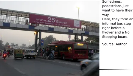
And where roads do run, foot over bridges (FOBs) and subways are to be employed to allow pedestrians to cross the road safely. However, this requires careful planning and location. A study by the Transport Planning Department of the School of Planning and Architecture has revealed that pedestrians in different countries differ in their tolerance level, in terms of the time they are willing to spend at a road junction to cross it before they jaywalk, with pedestrians in Delhi willing to wait an average of 75
seconds. (Kant, V, 2014) FOBs and subways are overlooked as they view it as physically taxing, with pedestrians preferring to cross at junctions. A cause for concern is the growing tendency in Delhi to forcibly restrict people from crossing the road by making signal free traffic corridors and raising the height of the central dividers on the roads. According to an assessment report by the Centre for Science and Environment (CSE), this limits sustainable modes like cycling, walking and public transport usage and has actually increased safety risk as people still attempt to cross the roads. (The Hindu, 2014)
Fig 7
Urban Vitality
An important point to note while designing a pedestrian area is that it should allow for shopping, relaxing, eating, meeting up with people and other social activities. Zoning is the key element in the creation of an active atmosphere that is both comfortable and attracts more people to the area. People should not be limited to any specific activity in a space. If one were to analyse New Delhi, it is observed that large parts of the city have been built as per a 'single-use design' model: sections of the city are devoted almost exclusively to a particular purpose – residential, industrial, commercial or institutional and tends to be separated from each other using roads, open spaces or other barriers. The original intention was to ensure that residents would not have to live in cramped spaces or near industrial plants and their constant disturbance and pollution. However, even after industrialization, Delhi has continued following this American model of suburban sprawl. Today, individual zones have grown so large that the distances between them are vast, making movement difficult (Padukone, N. 2014). A resolution for the same at an urban planning scale is to have integrated, mixed use planning. Shorter distances make walking and cycling to destinations more convenient. This is advantageous as it will result smaller carbon footprints and better access to economic
opportunities, making life more efficient and convenient for work, leisure, home, and childcare. This is necessary for urban vitality - the synergy arising from a 'variety' of somewhat 'unique' commercial and
entertainment opportunities and a dense socially heterogeneous pedestrian population. (Mass, Paul R, 1984)
Security and Comfort
Such a system is also beneficial to the security of a metropolis. If an area is used for multiple purposes, there will always be somebody - a
homemaker, shopkeeper, pedestrian, peddler, or office worker - keeping a passive watch, inadvertently but effectively policing it 24 hours a day. Street vendors, for example, may be the most perennial pairs of eyes that monitor any streets, a fact already realized and utilized by the Surat
police. (Saiyed, K., 2012) This follows what urbanist Jane Jacobs (1961) theorized in her magnum opus ' The Death and Life of Great American Cities’, An urban street should be able to welcome and handle both the local population as well as visitors in the area, and using that to its
advantage. A successful metropolitan area is generally characterised by 3 qualities. First, there should be a clear demarcations between the
identification of public and private spaces in the area. Unlike rural and suburban areas, Public and private spaces in a city cannot amalgamate. The difference should be clearly demarcated. Second, is the presence of 'eyes upon the street' – By having residences in the area face the streets, there rises a high chance that multiple eyes are watching the street at any given point, thereby ensuring safety of the pedestrians and in turn the safety of the area. Hence both residents and visitors benefit from this. Third, the streets should be active and must have people using it fairly continuously. This is advantageous in two ways. It means that there are more eyes on the street, enhancing point two. Also, it makes the streets lively. Though no one enjoys watching empty streets, watching street activity serves as a means for passing time for many people. Thus, active streets result in safer and livelier environments. (Jacobs, J, 1961)
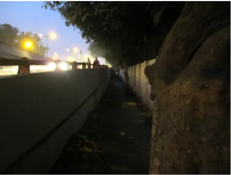
Fig 8:
Source:
https://courses.cit.cornell.edu/
Fig 9: Pedestrian path, Moolchand Flyover; Source: Author
Chapter 4:
Sustenance
Cycling
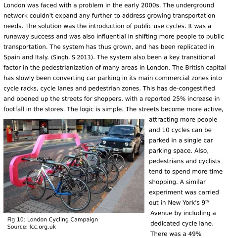
London was faced with a problem in the early 2000s. The underground network couldn't expand any further to address growing transportation needs. The solution was the introduction of public use cycles. It was a runaway success and was also influential in shifting more people to public transportation. The system has thus grown, and has been replicated in Spain and Italy. (Singh, S 2013). The system also been a key transitional factor in the pedestrianization of many areas in London. The British capital has slowly been converting car parking in its main commercial zones into cycle racks, cycle lanes and pedestrian zones. This has de-congestified and opened up the streets for shoppers, with a reported 25% increase in footfall in the stores. The logic is simple. The streets become more active,
attracting more people and 10 cycles can be parked in a single car parking space. Also, pedestrians and cyclists tend to spend more time shopping. A similar
experiment was carried out in New York's 9th
Avenue by including a dedicated cycle lane. There was a 49% increase in retail sales. (Burgess, K, 2014)
30 Fig 10: London Cycling Campaign
A cause for concern is the ill maintenance of cycle tracks in Delhi. Set up during the 2010 Common Wealth Games, Delhi claims to have 100kms of cycle tracks, even some running along arterial roads. But these are
disconnected pathways and lack kerbed ramps and blended crossings, ultimately being broken paths that lead to nowhere. It is also common for shop owners, vendors and the parking mafia to encroach on pavements meant for pedestrian and cyclist use. In Delhi, there are plans and laws to protect pedestrians and their space. It is a punishable offence, but almost always gets overlooked by our law enforcers. Even the measly Rs.100 fine for a vehicle entering a cycle track has rarely been enforced. Maintaining a cycle track requires minimal investments. Yet, the public funds are primarily invested on widening our roads to decongest vehicular traffic. However, new roads only attract more cars and with 21% of open area already being used for its road network, Delhi is approaching near saturation limits. (Singh, S 2013)
Upkeep
The quality of the pedestrian networks created should be realized. As the saying goes, build well or don't build at all. The actual nature of any transport design is dependent upon the tempo of movement, its purpose and character. Pedestrian design should engage the user, with focal points and other characteristic punctuations. This can be done in a variety of ways, essentially identifiable as those which can be done at a planning level and those that act as landscaping elements.
At a planning level, the aim is to break continuity so that a pedestrian is intrigued and drawn in by the space. We can broadly arrive at the
with the scales. Even a straight path leading through a variety of spaces gets identified as unique areas. A more stark approach is to demarcate differences by using varying materials and textures. Different paving and building treatment provide contrast. The most important aspect is mixed use planning as has been already established.
Public Participation
The involvement of the public can go a long way in transforming a city. An important example of transformation in a developing country is the city of Bogotá in Colombia. Just 20 years ago, Bogota was in a state of near anarchy. It was ravaged by drug wars and gang violence and had steep urbanization rates of almost 90 percent. This is significantly higher than India, where we urbanization happens at 35% as of 2014. However, radical interventions and a committed leadership progressively altered Bogota's urban scape with efficient public transportation networks and recaptured spaces for open public use. They encouraged mixed use design, and laid emphasis on people and pedestrian movement. The resultant outcome we see today is a highly lauded model of urban
development with greatly reduced violence, enhanced social access, and an established sense of civic safety and pride. (Paredukone, N, 2014) Indian cities should act before it’s too late and avoid failures like Riverside,
California, where vacancy rates had already reached 16% by the time pedestrian revival plans were laid out. (Brambilla, R, Longo, G 1979)
32
Localisation is perhaps the most important aspect of any system. Designs should be made to suit local culture and geography. An innovation in this regard is the 'bicycle escalator' that was introduced in Trondheim, Norway, to prevent steep hills from deterring casual cyclists. A cyclist merely has to keep this foot on the stand, which will push him up the hill at speeds of 3-4miles per hour. (Memolution)
Landscaping
Landscaping is also key to a making a street an urban spill out area. Fountains, pools, playgrounds, sculptures and soft landscaping features are a welcome relief to pedestrian as they break the otherwise
views from windows as well as the shade offered by the trees from the sun. Retaining existing greenery adds cultural value and should hence be protected. (Vats, N, 1992) Not much insight was received into the
advantage offered by decorative landscaping elements and their role in creating 'pleasurable walking experiences', serving as an opportunity to do a hangs on analysis for a topic with little existing research. An ongoing experiment is in the town of Elmira, New York. Since 2008, the district administration has been promoting graphic artworks on public electric boxes with its 'Pop Art Elmira' project, encouraging the residents to
residents to bring out the life of the area through street graffiti. The town has also invested in storefront facelifts, sign improvements and
streetscape enhancements. The aim is to get people to notice and absorb the culture. And it’s not just limited to visitors. The project has already been influential in revitalising the locals, helping them to (re)discover places in a whole new light and has generated intrigue about Elmira. Potentially leading to larger forms of investment (Finger, R, 2014)
Lighting is another key aspect of a street. Functionally, they must provide for adequate lighting in the streets, ensuring visibility and security after dusk. This builds on Jane Jacobs's 'eyes on the street' concept. The more visible an area is, more the likelihood of having observers. They are also decorative elements that lend character to the street. They also
implement functionality and serve as a unifying influence over the city. They can also be used in different ways. They can set the mood of a street based on the warmth of their light and can also be used to highlight public attractions like bus stops, sculptures and monuments, thereby adding a whole new perspective to street character. (Vats, N, 1992)
Chapter 5:
CASE STUDIES
Case studies were conducted by first identifying high footfall areas in Delhi.
The transit hubs of Kashmere Gate ISBT, Sarai Kale Khan ISBT, Anand Vihar ISBT are areas of extremely high footfall. As transit hubs, they are a critical node for the movement of the urban pedestrian. However, a
proper first-hand analysis was beyond the scope of this dissertation. So a secondary case study was performed by analysing data from a2009 Transport Planning Thesis Report on ‘Planning of Pedestrian Friendly Design in Transit Areas’ by Ganguly, S.
ITO presents itself as a high footfall location which is also convenient to survey.
Residential areas tend to have a lot of pedestrian movement. They are areas where safety, comfort and free movement is of prime importance. Greater Kailash was rated as the safest area in Delhi by Times of India in 2009.
India Gate is the most iconic structure in Delhi and possibly the most visited area in Delhi, both as a monument as well as an expansive green to relax upon.
Note: Other areas identified are the shopping districts of Connaught Place, Nehru Place and South Extension. However, pedestrian flow in shopping districts tend to rush and were generally unwilling to pause to fill in
SECONDARY CASE STUDY
Kashmere Gate ISBT
In Delhi, there are three major inter State Bus Terminals and several bus stations which serve the Delhi population. They also operate for local bus services. They are
Kashmere Gate ISBT Sarai Kale Khan ISBT
Anand Vihar ISBT
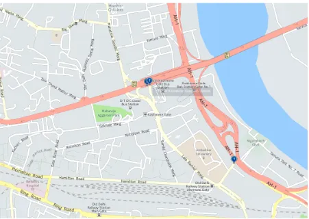
Fig 12: Map of Kashmere Gate ISBT; Source: here.com
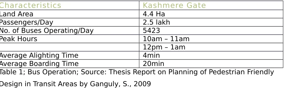
The Kashmere Gate bus terminal is located in the North East part of the city, at a junction of major arterial roads, including a National Highway. It handles about 60% of bus services in Delhi, catering to nearly 2.5 lakh
passengers per day. ISBTs have great potential to be the transit node for inter change of passengers from one mode of transport to another. The Kashmere Gate metro station and the old Delhi railway station are thus conveniently located right next to the terminal.
Characteristics Kashmere Gate
Land Area 4.4 Ha
Passengers/Day 2.5 lakh
No. of Buses Operating/Day 5423
Peak Hours 10am – 11am
12pm – 1am
Average Alighting Time 4min
Average Boarding Time 20min
Table 1; Bus Operation; Source: Thesis Report on Planning of Pedestrian Friendly Design in Transit Areas by Ganguly, S., 2009
Even with a heavy pedestrian influx, channelization of pedestrian movement is absent, leading to pedestrians straying over the entire region. The ISBT has multiple entries, which act as a point of attraction for commuters using various modes who choose to alight randomly for
ingress. These pockets of stationary vehicles disrupt the normal flow of traffic. Modal interchange catering to local commuters also adds to the chaotic situation on the arterial road.
Characteristic s
Specifi cations
Road Name Ring Road Nityanand Marg
Shamnath Marg
Lothian Marg
Right of Way 90m 45m 30m 30m
Carriage way Type
8 lane divided
6 lane divided 6 lane divided 6 lane divided Carriage way
Width
32m 24.5m 24m 24m
Footpath Width 5.5m 4.5m 3m 3m
Median 2m 2m 1.5m 1.5m
Public Crossing FOB - -
Pedestrian Analysis
Constitution
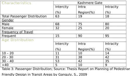
There are 3 distinct types of users at the ISBT. Intercity travellers, intracity travellers and intra region travellers.
Characteristics Kashmere Gate
Total Passenger Distribution 63 19 18
Gender
Table 3: Passenger Distribution; Source: Thesis Report on Planning of Pedestrian Friendly Design in Transit Areas by Ganguly, S., 2009
Most of the passengers lie in the age group of 20-40 so pedestrian facilities should be planned keeping that in mind. Also, 32% of trips are recreational, 21% social, 37% work and 11% educational.
User Survey
User surveys were done to understand perception and preference.
Lack of Information/ Signages
Lack of Side Walks
Lack of Safe Crossings Lack of Illumination
Lack of Police Enforcement
0 50
PEdestrian infrastructure
Intensity
45.00%
20.00% 25.00%
10.00%
Preference For Crossing Road
Poor surface of Sidewalk
From the data collected, the following observations were made:
Pedestrians are satisfied with the police enforcement and street illimunation in the area. Thus, there is a sense of security and comfort.
It is an easy area to navigate and move around
Most pedestrians feel the reason for walking on roads instead of sidewalks due to encroachment by shopkeepers
Almost all pedestrians agree that the lack of proper sidewalks
and safe crossings is a major hindrance to pedestrian movement
There is a major preference for using zebra crossing and for crossing the road at red light. This could indicate a lack of preference for climbing stairs to cross the road
Also, between FOBs and subways, there is a clear preference
PRIMARY CASE STUDY
Architecture Block, SPA Delhi
The School of Planning and
Architecture is a premier National Resource Institute 9of India,
specialising in Architecture and Planning. The architecture block is located in Central Delhi, on the Ring Road, near ITO. The Planning Block
is located 600m away at the ITO intersection. The architecture block houses 600 students and over a 150 faculty an d supporting staff during working hours, which are typically on weekdays from 9 am – 5 pm. The college is located in a central administration district with a lot of footfall. Directly across the ring road lies the Indira Gandhi Indoor Stadium. The area is home to the Delhi Police Headquarters, IIPA, Delhi Secretariat, WHO South Asian Headquarters, NCAER and more.
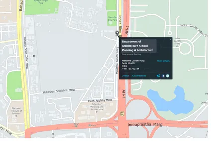
Fig 13: Architecture Block Source: spa.ac.in
Characteristics Architecture Block, SPA Delhi
Land Area 6779.6 SQ
Foot fall/ Day 750
Working Hours 9 am – 5 pm
Characteristics
Road Name Ring Road Indraprastha Marg Inner Ring Road
Right of Way 90m 45m 12m
Carriage way Type 8 lane divided 6 lane divided 2 lanes Carriage way
Width
32m 24.5m 24m
Footpath Width 5.5m 4.5m 5.5m
Median 2m 1m
-Public Crossing - FOB
-Table 4: Adjacent Roads; Source: Author
Pedestrian Analysis
The students are of an age group of 17-28. They require cheap means of transport. Especially since the hostel is 10km away from the college. Many people also stay in and around the hostel, amounting to roughly half of the student constitution of the college. The Indira Gandhi stadium also attracts teenage crowds for its sports facilities. However, even with a heavy pedestrian influx, channelization of pedestrian movement is absent.
The college and the stadium are located across a curve in the 8 lane ring road. Also, it is a point of a double split in the ring road, where the
Indraprastha Marg and the Inner Ring Road merge with the ring road. However, there is no immediate facility for the students to cross the road safely.
Bus stops are located on either side of the road. The one on the side of the college is located 150m from the college gate but those wanting to use public bus for transportation back to the hostel are expected to either walk 700m to Rajghat or 600m to the ITO flyover in order to reach a zebra crossing. Thus, in order to reach the bus stop to travel South on the ring
road, pedestrians would have to walk a minimum of 1.3km. However, these zebra crossings have 120 second intervals between which they give pedestrians just 10 seconds to cross. Also, the ITO crossing is shut down between 6.30pm – 8pm, making it even more difficult for pedestrians.
There is no auto stand near the college. However, there are some auto drivers who wait for students near the gate around lunchtime and at 5pm, to ply the college - hostel trip.
User survey
User surveys were done to understand perception and preference. A user base of 50 students were chosen at random for the survey.
By observation, it was noted that people primarily use 3 methods of transport – Private vehicles, Auto rickshaws and Public Transport, which includes a primary mix of metro and bus. This was the result of the survey.
37.50%
40.00% 22.50%
Preference Of Transport
36.00%
28.00% 19.00%
17.00%
Preference For Crossing Road
Zebra Crossing (36%) Jaywalking (28%) FOBs (19%) Subways (17%)
Lack of Signages
Lack of Side Walks Lack of Police Enforcement
0 5 10
PEdestrian infrastructure
Broken Sidewalk
A visual survey was conducted at the college gate during the peak hour of 5-5.30pm on a working day. It was observed that 37 people jaywalked across the ring road during that window. 16 walked to the bus stop on the side of the college or towards ITO. Approximately 120 (an accurate figure couldn’t be arrived at) people chose to leave either by auto or by private transport during the same window. There is a complete lack of a facility for safe pedestrian crossing across the 8 lane ring road.
Observations & Inferences
The survey revealed a distrust in the efficiency of police
enforcement. Many quoted the lax attitude of the police in effectively preventing paedophiles from harassing students on the 600m stretch between Architecture and Planning Block, despite the Delhi Police
Headquarters being only 350m away from it. The path is lined with trees
which provide shade during the day but act as hiding places for
paedophiles in the evening. Lack of proper illumination accentuates the issue.
An intervention in the form of a police post on the stretch can provide pedestrians with security and comfort.
The user group has a low opinion on Delhi’s pedestrian
infrastructure, blaming encroachment by shopkeepers, lack of footpath width in places, broken footpaths and obstructions like trees, garbage and parked cars as major hindrances to pedestrian movement.
PRIMARY CASE STUDY
Kailash Colony
Kailash Colony is a residential area located in South Delhi, comprising of several neighborhoods and multiple markets. Greater Kailash (GK) is a recent expansion, divided into two zones, namely Part 1 and 2, located around a section of the Outer Ring Road. In 2009 Greater
Kailash was rated as the safest place in Delhi by Times of India.GK is one of the more affluent
neighborhoods in the city. The markets in M and N Block are some of the most popular markets in Delhi, home to a wide range of retail stores and restaurants. It is one of the largest hubs for sanitary ware in Northern India. It experiences a lot of footfall because of the same.
50 Fig 15: Kailash Colony Metro Station Source: en.wikipedia.org
However, according to Tanu Thomas, the same can’t be said of the Kailash Colony. While the place used to be a dream locality with parks,
unobtrusive markets, wide roads, good drains, mismanagement has led to encroachments and illegal constructions in the area. This inevitably leads to traffic congestion, which is further worsened by the pathetic condition of the roads. Residents complain that it can take up to an hour just get their cars through the market.
The residents have no respite in the colony park either. What used to be a proud asset of the colony has now turned into a den for illegal activities at night, making the area unsafe, especially concerning women. (Thomas, 2003). This has also lead to the vegetable market that used to be on the periphery, encroaching upon the park. Besides making the place dirty, it has become a nuisance for residents living near the park, as the garbage is rarely cleared.
Incidents of violence are also prevalent in the area. On October 02 2014, clicking the pictures of an under-construction building led to clashes
between local residents and three people from Assam, including a woman. The three Assamese people and another person sustained minor injuries during the melee. The user survey was carried out in the same week.
25.88%
18.96% 23.97%
31.19%
Preference For Crossing Road
Zebra Crossing (26%) Jaywalking (19%) FOBs (24%) Subways (31%)
Observation & Inferences
There is a clear preference for Subways over Foot over bridges, unlike the surveys taken at SPA and at Kashmere Gate.
The survey also suggests a high preference of jaywalking. Though only 20% had jay walking as their primary preference, 50% of the remaining user group said that it would be their second choice. It should also be noted that unlike the other case studies, the roads here are narrower and hence easier to cross.
Regarding pedestrian infrastructure, feedback shows us that while illumination, signage and sidewalks were adequate, there are issues regarding safety on the street, even with it being a residential area.
Residents express a lack of safe crossings and have low faith in the police enforcement in the area.
Being an area prone to traffic congestions, provisions should be made for pedestrians to cross streets safely, especially near markets, which tend to be the centres of congestion. Zebra crossings and subways are the public preference. However, considering the intensity of congestion problems, the option of making markets a pedestrian zone should also be explored.
The area has adequate footpaths and the residents have a lukewarm response about built in obstructions and vehicular parking on the streets. However, a visual survey did note a lot of cars being parked on the roads.
Broken footpaths and the encroachment by shopkeepers is a large
problems. Authoritative regulation is necessary so as to reclaim the foot paths for the pedestrian.
PRIMARY CASE STUDY
India Gate
Originally called the Indian War Memorial, India Gate now stands as possibly the most iconic structure in New Delhi and even perhaps the whole of India. It has a lot of footfall and remains open 24/7, being a prime tourist destination as well as a place frequented by locals to meet up and relax.
India Gate has the Rajpath connecting it to the Rashtarpati Bhavan, which forms an axis for the planning of Lutyen’s Delhi.
India Gate has a broad hexagonal road running around it, which also acts as a nexus for major roads like Tilak Marg, Dr. Zakir Hussain Marg,
Shajahan Road, Akbar Road, Ashoka Road, KG Marg, Copernicus Marg and Tilak Marg.
55
Pedestrian Infrastructure
There C-Hexagon has 5 zebra crossings for pedestrians, which are located at Zakir Hussain Marg, Kasturba Gandhi Marg. Rajpath, Tilak Marg and Shahjahan Road junctions. They have a 30-second signal for pedestrians to cross the C-Hexagon every 150 seconds.
37.14%
14.05% 24.93%
23.87%
Preference For Crossing Road
Zebra Crossing (37%) Jaywalking (14%) FOBs (25%) Subways (24%)
Lack of Signages
Lack of Side Walks
Lack of Safe Crossings Lack of Illumination
Lack of Police Enforcement
-2 3 8
PEdestrian infrastructure
Intensity (on 10)
Broken Sidewalk
Lack of Footpath width
Built-in Obstructions (poles, garbage,trees) Vehicle Parking on footpath
Enroachment by Shopkeepers
0 5
Hinderences encountered on sidewalk
Observations & Inferences
Even with the heavy pedestrian influx, jay walking was minimal. Most people waited patiently for the traffic light. The same was reflected in the user survey. Only 14% of people had a preference for jaywalking with the
majority (37%) preferring zebra crossings. There seems to be a neutral outlook regarding FOBs and subways.
The India gate precinct thus presents itself as a good pedestrian environment.
The study group expressed general satisfaction with the pedestrian infrastructure in Delhi. However, though content with the infrastructure provided, they expressed dissent regarding the encroachment on
pedestrian paths by vehicles and shops.
Conclusion
The case studies have revealed that the major hindrances to smooth pedestrian movement is encroachment by shops and vehicular parking on footpaths meant for pedestrian movement. This inference has resonated across all the case studies.
This will require changes at the policy making level. The Municipal
Corporations of Delhi should also ensure proper enforcement of laws and tow away vehicles parked on footpaths and curb encroachment by shops by imposing large fines and/or cancelling their licences. This will clear the path for pedestrians to move freely. Discouragement of vehicular
movement by drastically hiking parking charges to (near) European levels is an option that will encourage public transport, provided that public transport infrastructure is improved accordingly.
The city also rates low on comfort and safety. Street lamps, as well as more ‘eyes on the street’ should be set up. Vendors and police posts go a long way in enforcing security on a street. Future expansions of the city should be done in a mixed use manner instead of the large single purpose spaces of today. Commercial and Business districts become inactive at night, making waking an uncomfortable experience.
Urban streetscapes are identified with the activities and architecture of an area. They are manmade and defined by design and usage pattern. The role of a street is to fulfil a need for a connected public space, accessibility for people and goods and as a means of providing light and air in an area. And as streets act as a barrier for the separation of public and private space, it is also the locus of the active definition of private and public. Treatment of streets is therefore a very decisive factor for the urban
APPENDIX
REFERENCES
Books
Akshima T Ghate and S Sundar, 2014, 'Proliferation of cars in Indian cities: Let us not ape the West’ The Energy and Research Institute, Viewed 12 July 2014,
http://www.teriin.org/policybrief/index.php?a=13
Choudhury, A, 1989, ‘Pedestrian – Priority Zones’,Unpublished,Dissertation, SPA Delhi
S. Manchanda, 1997, ‘Pedestrianisation in Group Housing’, Unpublished,Dissertation, SPA Delhi
Roberto Brambilla, Gianni Longo, 1979, 'Pedestrian Areas: Notes on Their Successes and Failures', Process Architecture, Tokyo
Namiki Oka, 1979, 'New Direction in Urban Transport', Process Architecture, Tokyo
Jane Jacobs, 1961, The Death and Life of Great American Cities, Vintage Books, New York
Nagendar Vats, 1992, Street Design, Unpublished, Dissertation, SPA Delhi Jayati Dar, 1994, 'Pedestrian Friendliness in Central Areas', Unpublished, Dissertation, SPA Delhi
Mass, Paul R, 1984, 'Towards a theory of urban vitality', University of British Columbia, Viewed 14 July 2014, http://circle.ubc.ca/handle/2429/25171
Lydia Kiroff, 2002, ‘Visual Language in Architectural Design’, Thesis, UNITEC, Auckland, NZ,
http://unitec.researchbank.ac.nz/bitstream/handle/10652/1491/Lydia%20Kiroff %20MDM.pdf?sequence=1
Forster, K., 1999, ‘Why are some buildings more interesting than others?’, Harvard Design Magazine, Winter/Spring 1999, No.7,
http://www.scribd.com/doc/47419969/why-are-some-buildings-more-interesting-than-others
Articles
Shivani Singh, 2013, 'Car capital Delhi couldn’t care less for millions of cyclists', October 28, Viewed 14 July 2014,
http://www.hindustantimes.com/comment/shivanisingh/car-capital-delhi-couldn-t-care-less-for-millions-of-cyclists/article1-1142467.aspx#sthash.TQVx365w.dpuf
Dipankar Ghose, 2013, ‘Rly stations play catch up, ETA 2014’, July 26,Viewed Nov 08 2014 http://archive.indianexpress.com/news/rly-stations-play-catch-up-eta-2014/1146759/3
Nilanjana Bowmick, 2014, 'Delhi's air has become a lethal hazard and nobody seems to know what to do about it', February 10, The Time,
Viewed 14 July 2014,http://time.com/6061/delhis-air-has-become-a-lethal-hazard-and-nobody-seems-to-know-what-to-do-about-it/
Rahul Tandon, 2013, 'Why has India's Calcutta city banned cycling?', October 20,
BBC News, Viewed 14 July 2014, http://www.bbc.com/news/world-asia-india-24237390
‘10 ways to unclog Delhi: L-G Jung accepts HT's suggestions’, The Hindustan Times, September 13, Viewed October 03 2014,
http://www.hindustantimes.com/india-news/newdelhi-unclogdelhi/10-ways-to-unclog-delhi-l-g-jung-accepts-ht-s-suggestions/article1-1263533.aspx
Neil Padukone, 2014, 'How Urban Design Could Help Reduce Rape in India',
Citylab, June 6, Viewed 16 July 2014, http://www.citylab.com/crime/2014/06/how-urban-design-could-help-reduce-rape-in-india/372612/
Kelly Sinoski, 2012, 'Cities tackle congestion with driver fees', Vancouver Sun, October 26, Viewed 16 July 2014,
http://www.vancouversun.com/news/Cities+tackle+congestion+with+driver+fee s/7454901/story.html#ixzz38BPU8GLt
Kaya Burgess, 2014, 'More cycle racks and less parking ‘will revive struggling high streets’, The Times, Viewed July 18 2014,
http://www.thetimes.co.uk/tto/public/cyclesafety/article4098948.ece
Gajanan Khergamker, 2014, 'Gateway stretch set to become city’s first pedestrian zone', Afternoon Despatch & Courier, Viewed 20 July 2014,
http://www.afternoondc.in/city-news/gateway-stretch-set-to-become-citys-first-pedestrian-zone/article_108577
Ray Finger, 2014, Visual enhancements have impact on Elmira', July 19, Star Gazette, Viewed July 20, 2014,
http://www.stargazette.com/story/news/local/2014/07/19/making-elmira-look-better/12841639/
Bicycle Escalator Helps Cyclists in Norway Climb Hills, Viewed 21 July 2014, http://memolition.com/2014/07/16/bicycle-escalator-helps-cyclists-in-norway-climb-hills/
Vishal Kant, 2014, 'Indian jaywalkers run out of patience after 75 seconds, reveals study', The Hindu, August 18
Dwaipayan Ghosh, 2009, GK, ‘C R Park among 24 safe city colonies’, Times of India, Viewed October 10 2014,
http://timesofindia.indiatimes.com/city/delhi/GK-C-R-Park-among-24-safe-city-colonies/articleshow/5354576.cms
Tanu Thomas, 2003, ‘Kailash Colony not a dream location anymore’, Viewed October 10 2014,Times of India
http://timesofindia.indiatimes.com/city/delhi/Kailash-Colony-not-a-dream-location-anymore/articleshow/37795896.cms
'Are foot over-bridges the best way forward in Delhi?', The Hindu, August 18
2014, ‘Delhi: Northeast students click pics, beaten up’, October 2, Hindustan Times, Viewed October 4 20014, http://www.hindustantimes.com/india-news/newdelhi/north-east-students-click-pics-beaten-up/article1-1270822.aspx
Tara Parker-Pope, 2010, 'The Pedometer Test: Americans Take Fewer Steps', The New York Times, October 19, Viewed 18 June 2014,
http://well.blogs.nytimes.com/2010/10/19/the-pedometer-test-americans-take-fewer-steps/
Kamaal Saiyed, 2012, 'Surat cops seek hawkers’ help to curb crime', The Indian Express, March 8, Viewed 20 July 2014, Journalism of Courage Archives database. Vijay Goel, 'Chandni Chowk - The Unkempt Paradise', Viewed July 20 2014,
http://www.vijaygoel.in/pages/in-news-328
Documents& Statistics
Mayank Shekawat, Vedika Aggarwal, 'The planning and design of Lutyen's Delhi', Slideshare, Viewed 20 July 2014,
http://www.slideshare.net/VedikaAgrawal/planning-of-lutyens-delhi-28123179
Delhi Development Authority, 2011, Minutes of the 29th UTTIPEC Governing body
meeting, Viewed July 20, 2014,
http://uttipec.nic.in/writereaddata/linkimages/3621141954.pdf
List of car free places, Viewed 20 July 2014,
City Mayor Statistics, 2007, 'The largest cities in the world by land area, population and density', Viewed 14 July 2014,
http://www.citymayors.com/statistics/largest-cities-density-125.html
Basic Questionnaire:
Option Weights: Q 1:
Never 0; Last Option 1; Chalta he 2; Preference 4 Q 2&3:
Srongly disagree -2; Disagree 0; Neither agree nor disagree 1; Agree 3; Strongly agree 5.