FACULTY OF ARCHITECTURE, PLANNING AND SURVEYING
UNIVERSITI TEKNOLOGI MARA
PUNCAK ALAM
GEO TOURISM: TRANDFORMING GUNUNG LANG RECREATIONAL
PARK AS GEO PARK THROUGH GEOLOGICAL AND ECOLOGICAL
APPROACH
NUR MUHAMAD FIRDAUS BIN MUSTAFA KAMAL
2015856844
FACULTY OF ARCHITECTURE, PLANNING AND SURVEYING
UNIVERSITI TEKNOLOGI MARA
PUNCAK ALAM
GEO TOURISM: TRANDFORMING GUNUNG LANG RECREATIONAL
PARK AS GEO PARK THROUGH GEOLOGICAL AND ECOLOGICAL
APPROACH
NUR MUHAMAD FIRDAUS BIN MUSTAFA KAMAL
2015856844
Thesis submitted in partial fulfillment
of the requirements for the degree of
Bachelor of Landscape Architecture (Hons)
I declare that the work on this project/dissertation was carried out in accordance with the regulations of Universiti Teknologi MARA. The project/dissertation is original and it is the result of my own work, unless otherwise indicated or acknowledged as referenced work. In the event that my project/dissertation be found to violate the conditions mentioned above, I voluntarily waive the right of conferment of my degree of the Bachelor of Landscape Architecture (Hons) and agree be subjected to the disciplinary rules and regulations of Universiti Teknologi MARA.
Name of Student : Nur Muhamad Firdaus Bin Mustafa Kamal
Student’s ID No : 2015856844
Project/Dissertation Title : Geo Tourism: Transforming Gunung Lang Recreational Park as Geo Park through Geological and Ecological Approach Case Study : Gunung Keriang, Kedah.
Signature and Date :
Approved by:
I certify that I have examined the student’s work and found that they are in accordance with the rules and regulations of the Department and University and fulfills the requirements for the award of the degree of Bachelor of Landscape Architecture (Hons).
Name of Supervisor :
i
ii
In the name of ALLAH S.W.T, I am grateful for the blessing for giving me this great opportunity to complete this thesis, Geo Tourism: Transforming Gunung Lang Recreational Park as Geo Park through Geological and Ecological Approach. First of all I would like to give my gratitude to my parent for supporting me days and night until the thesis is completed. Also to my superb and amazing supervisor, LAr. Abu Hassan Wahab, I am extremely thankful for sharing knowledge, valuable guidance and encouragement throughout the process.
My appreciation goes to my studio lecturers, LAr. Dr. Nurhayati Abd. Malek, LAr. Abu Hassan Wahab, LAr. Zalina Jaal and LAr. Nurulhuda Hayati Ibrahim for all guidance, advices and knowledge while carrying this dissertation studies. I also take this opportunity to express gratitude to all the Center of Studies for Landscape Architecture members for their help and support.
iii
CHAPTER 1: INTRODUCTION TO TOPIC
1.0 Introduction 1
1.5 Research Methodology 6-7
iv
1.9 Chapter Summary 11
CHAPTER 2: LITERATURE REVIEW AND REFERENCE CASES
2.0 Introduction 12
2.1 Evolution of Geo Park Worldwide. 12-16 2.1.1 Unesco Global Geopark (UGG)
2.1.2 Global Geopark Networks (GGN)
2.1.3 Asia Pacific Geo Park Network (APGN) 2.1.4 Lembah Kinta Geo Park
2.2 Geo Park Perspective in Malaysia 18-20 2.2.1 Lembah Kinta
2.2.3 History of Lembah Kinta 2.2.4 Geology Lembah Kinta
2.3 Importance of Geopark Establishment 21-23 2.3.1 Principle in Geo Park Development
2.3.2 Relevant Authorities Related to Development of Geopark
2.4 Reference Cases 24-26
2.4 Gunung Keriang Recreational Park 2.4.1 Site Background
2.4.2 Aim of Project
2.4.3 Issues and Problems
2.4.4 Design Approach and Solution
2.5 Miri Airport Road Outcrop Museum 27-28 2.5.1 Site Background
2.5.2 Aim of Project
2.5.3 Issues and Problems
2.5.4 Design Approach and Solution
2.6 Comparison between Reference Cases 29
2.7 Chapter Summary 30
CHAPTER 3: SITE INVENTORY AND ANALYSIS
3.0 Introduction 31
3.1 Gunung Lang and Gunung Bilike 31-33 3.1.1 Location
v
3.3 Land Use and Activities 36-40 3.3.1 Development Zone
3.3.2 Land Use
3.3.3 Land Use Zones related to at GLRP 3.3.4 Land Used Activities
3.4 Accessibility and Circulation 41-51 3.5.1 ‘Kawasan Sensitif Alam Sekitar’ (KSAS)
3.5.2 Demarcation of Safety Zones In The Vicinity Of Limestone Hills. 3.5.2.1 Safety Zone Gunung Lang and Gunung Bilike Areas 3.5.2.2 Classification Of Cliff Faces In Limestone Hill.
3.5.2.3 Recommendation/Solution
3.5.3 Topography
3.5.3.1 Elevation Profile 3.5.4 Hydrology
3.6 Geomorphology 59-62
3.6.1 Lithology of Ipoh
3.6.2 Lithology of Gunung Lang Recreational Park 3.6.3 Geological Significance
3.7 Vegetation, Wildlife and Climatic Factor 63-69 3.7.1 Plant Communities and Wildlife
3.7.2 Climatic Factor
3.8 Site Sensory Study and Online Surveys 70-74 3.8.1 Online Surveys
3.8.2 Visual Quality Analysis 3.8.3 Site Sensory Study
vi
CHAPTER 4: SITE SYNTHESIS
4.0 INTRODUCTION 76
4.1 SWOT Identification 76
4.2 Issues 77-78
4.3 Potential and Significance 78-80 4.3.1 Potential of Gunung Lang, Gunung Bilike and Gunung Lang
Recreational Park.
4.3.2 Significance of Gunung Lang, Gunung Bilike and GLPK
4.4 Overlay Technique 81
4.5 Final Synthesis Map 82-83
4.6 Design Strategy 84-85
4.7 Chapter Summary 85
CHAPRER 5: FINDINGS AND DESIGN GUIDELINES
5.0 Introduction 86
5.5.1 Conceptual Diagram
5.5.2 Functional and Programming Diagram 5.5.3 Preliminaries Plan
5.6.1.2 Zone 2 (Geo Experience) 5.6.1.3 Zone 3 (Geo Camp) 5.7 Enlargement 1
vii
Table 2.0 Comparison study between each reference cases. 29 Table 3.0 Citizens density for development block 6. 36
Table 4.0 Activity related to land use. 40
Table 4.1 KSAS classification of environmental sensitive area 52 Table 4.2 Plant communities and wildlife in GLRP. 63-66 Table 4.3 Visual quality analysis assessment. 71 Table 4.4 Table valuation and criteria of Gunung Lang. 73
LIST OF FIGURES
Figures 1.4 Organization chart of Geopark associates 17 Figures 1.5 Geoforest park with beautiful river. 18
Figures 1.6 Kilim Geoforest Park signage. 18
Figures 1.7 Karst landscape. 18
Figures 1.8 Gunung Lang Recreational Park. 19
viii
Figures 2.1 Tasik Cermin, Gunung Rapat. 20
Figures 2.2 Key plan 24
Figures 2.3 Location plan 24
Figures 2.4 Entrance of Gunung Keriang Recreational Park. 25 Figures 2.5 Rock site Gunung Keriang Recreational Park. 25
Figures 2.6 Key Plan. 27
Figures 2.7 Location Plan. 27
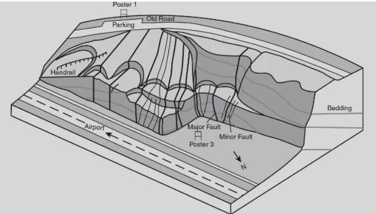
Figures 2.8 The outstanding outcrops that can be seen. 27 Figures 2.9 A 3-d sketch of the Miri Airport Road Outcrop showing 28
the fault lines
Figures 3.0 Key plan 31
Figures 3.1 Location plan 31
Figures 3.2 Panoramic view of Gunung Lang Karst Landscape 33 Figures 3.3 View towards Gunung Bilike from park area. 33 Figures 3.4 View towards Gunung Bilike from jetty area 33 Figures 3.5 Aerial view of Gunung Lang Recreational Park. 34 Figures 3.6 View towards scenic backdrop of Gunung Lang. 35 Figures 3.7 View from observation tower towards Gunung Lang main lake. 35 Figures 3.8 View towards mini waterfall which 47 meters heights. 35
Figures 3.9 Swamp/pond. 37
Figures 4.0 Groundwater of Gunung Lang. 37
Figures 4.1 Cat fish pond 37
Figures 4.2 Main lake of Gunung Lang Recreational Park. 37
Figures 4.3 Playground area in GLRP. 37
Figures 4.4 Parking space at GLRP. 37
Figures 4.5 View towards Limestone hills forest reserve of Gunung Lang 38
Figures 4.6 Persiaran Gunung Lang. 38
Figures 4.7 Kuala Kangsar road. 38
Figures 4.8 South-North Highway. 38
ix
Figures 5.1 Small factory machineries 39
Figures 5.2 Workshop and garage. 39
Figures 5.3 Terraces shop houses. 39
Figures 5.4 Plant Nurseries. 39
Figures 5.5 TNB sub station near commercial area. 40
Figures 5.6 Electric line tower. 40
Figures 5.7 Buddha temple 40
Figures 5.8 Petrol Station. 40
Figures 5.9 North South Expressway 42
Figures 6.0 Kuala Kangsar road 43
Figures 6.1 Persiaran Gunung Lang. 43
Figures 6.2 Jetty 2 at island area. 45
Figures 6.3 Jetty 1 at entrance area. 45
Figures 6.4 Lang 1 – Medium boat (18 -23 passenger). 46 Figures 6.5 Lang 2 and 3 – Small boat (8-12 passenger). 46 Figures 6.6 Soil erosion due to boat ride activity and loose soil structure. 46 Figures 6.7 12 meter wide asphalt footpath around Gunung Lang 48
Recreational Park are in good condition.
Figures 6.8 Building frontage of Ipoh Landscape and Recreation 48 Department made by concrete and pebble wash finishing.
Figures 6.9 ‘Laman Perak’ walkway are varies in materials and are 2 48 meters wide.
Figures 7.0 3 meter wide of fibre-like-wooden walkway at island area 48 that give connection to playground area.
Figures 7.1 3 meter wide of concrete imprint walkway 48 throughout the island area.
Figures 7.2 5 meter wide of asphalt road at the island area. This man 48 made cave access were used for maintenance and emergency
purposes.
x
Figures 7.5 View towards the observation tower from heritage plaza. The 49 condition of the boulevard are in great condition.
Figures 7.6 View towards the heritage plaza archway from boulevard 49 direction.
Figures 7.7 Unpaved path to man-made waterfall area which lack of 49 physical linkage.
Figures 7.8 Unpaved path to resting area at ‘Laman Perak’. 49 Figures 7.9 Cow path from the parking to the playground area. 50 Figures 8.1 View towards man-made waterfall. During peak hour, 50
this spot become crowded with visitor and activity.
Figures 8.2 Playground area for children in front of Jetty building 50 equipped with resting area.
Figures 8.3 Tourist waiting for their boat ride at Jetty near to cascading 50 waterfall.
Figures 8.4 Natural limestone wall and lake near exit of the park. 50 Figures 8.5 Attractive mural wall with seating equipment are the stop 51
by for visitors to take picture.
Figures 8.6 Dinosaur theme playground give attraction to family 51 and children at island area.
Figures 8.7 Malay traditional house architecture at heritage plaza at 51 island area.
Figures 8.8 View towards mini-zoo. During peak hour, this spot become 51 crowded with visitor and activity.
Figures 8.9 Observation Tower give a glance view of the island area 51 and create an attraction to visitors.
Figures 9.0 The decking pathway is a spot for tourist to feed monkey and 51 fish beside act as a linkage to playground area.
Figures 9.1 Man-made cave give attraction to visitor to experience 51 cave features like stalactite and stalagmite.
Figures 9.2 Part of Gunung Bilike limestone hills safety. 53 Figures 9.3 Visible undercut can be seen at the foothill of Gunung Bilike 53
xi
Figures 10 Detention Pond at the jetty area 58
Figures 10.1 Natural earth swale channels towards groundwater below 58 Gunung Lang.
Figures 10.2 Conventional drainage flows towards the nearest outlet in 58 the area.
Figures 10.3 Main lake of Gunung Lang Recreational Park cater all water 58 runoff from Gunung Lang and Gunung Bilike.
Figures 10.4 Lithology time scale of limestone in Gunung Lang 60 Recreational Park.
Figures 10.5 Cave access from island area 60
Figures 10.6 Cave entrance behind Gunung Lang. 60 Figures 10.7 Stalactite beside of the existing cave 61 Figures 10.8 View inside the cave (maintenance access). 61 Figures 10.9 Panoramic view towards Gunung Lang Recreational Park 61
limestone wall
Figures 11 Close up of dripstone wall 61
Figures 11.1 Close up of limestone rock at GLRP. 62 Figures 11.2 Close up of marble rock at JMG Perak 62
Figures 11.3 Climograph of Ipoh. 67
Figures 11.4 Temperature graph of Ipoh. 67
Figures 11.5 Humidity graph of Ipoh 68
Figures 11.6 Samanea Saman trees provide a good shade along the 68 boulevard path during the afternoon.
Figures 11.7 A good shade area with comfortable seating space 69 attract user to relax and enjoy the park
xii
Figures 12 Shadow fall in the evening 69
Figures 12.1 Chart of geopark standing in Perak 70
Figures 12.2 View towards VOP 1. 72
Figures 12.3 View towards VOP 2. 72
Figures 12.4 View towards VOP 3 72
Figures 12.5 Natural key element of Gunung Lang Recreational 78 Figures 12.6 List of significance features in GLRP. 80 Figures 12.7 The six overlay maps in producing a final synthesis 81
Figures 12.8 Conceptual Development Process 87
Figures 12.9 Living Nature concept. 87
Figures 13 Geopark Gateway theme. 88
Figures 13.1 Conceptual Diagram 89
Figures 13.2 Conceptual Diagram 90
Figures 13.3 The section above shows KSAS table and Demarcation of 92 Safety Zones in Vicinity of Limestone hills infographic.
Figures 13.4 Entrance statement design ideas 93 Figures 13.5 Side view of flying fox structure. 93 Figures 13.6 Sketches showing overall structure of flying fox activity. 93 Figures 13.7 Simple section show hanging glass walk at IPOH signage 93 Figures 13.8 Geology gardens Monash University. 93
Figures 13.9 Rock climbing activity 93
Figures 14 Enlargement 1. 99
Figures 14.1 View towards entrance statement of Gunung Lang 100 Recreational Park – cave mimicking
Figures 14.2 View towards flying fox ramp – extreme 100 Figures 14.3 Blow up of elevator bridge and shallow deck area. 101 Figures 14.4 View towards ecological bridge from shallow deck 101 Figures 14.5 View towards elevator bridge and Gunung Lang Karst landscape 101
xiii
Figures 14.8 View towards elevator bridge from sky 103 Figures 14.9 Section A –A’ of Ipoh Sky Walk has a difference level 103
due limestone topography
Figures 15 Blow up of elevator bridge and sky platform and a 104 remarkable scenery
Figures 15.1 Aerial view towards Ipoh sky platform – 100 person 104 – 60 m height. Source: author.
LIST OF PLAN
Plan Title Page
Plan 1.0 Geo Park Lembah Kinta geo site boundaries. 16 Plan 2.0 Demarcation of Gunung Lang, Gunung Bilike and 32
Plan 2.8 Pedestrian flow at island area. 47
Plan 2.9 KSAS Plan of Ipoh. 52
Plan 3.0 Topographic Plan. 55
Plan 3.1 Hydrology Plan. 57
Plan 3.2 Lithology Plan of Ipoh. 55
Plan 3.3 Lithology Plan of Gunung Lang Recreational Park. 55
Plan 3.4 Rock outcrop plan 61
Plan 3.5 Sensory Plan of GLRP. 74
xiv
Plan 3.8 Preliminary masterplan of Gunung Lang Recreational Park. 91
Plan 3.9 Overall masterplan 94
Plan 4.0 Masterplan of Gunung Lang Recreational Park. 95
LIST OF ABBREVIATIONS
Abbreviations
JMG Jabatan Mineral dan Geosains Malaysia
GLRP Gunung Lang Recreational Park
KSAS Kawasan Sensiftif Alam Sekitar.
RTD Rancangan Tempatan Daerah
UNESCO The United Nations Educational, Scientific and Cultural Organization
UKM Universiti Kebangsaan Malaysia. GIS Geographical Information system UGG UNESCON Global Geoparks Networks,
UGGN Global Geoparks Networs,
APGN Asia Pacifitic Geopark Networks.
MBI Majlis Bandaraya Ipoh.
NUR MUHAMAD FIRDAUS 2015856844 1 INTRODUCTION TO THE TOPIC
1.0 INTRODUCTION
The concept of ‘Geo Park’ is derived from the development of geological diversity and the need to conserve geological heritage. In conferences, particularly the Malvern International Conference on Geological and Landscape Conservation that took place in London in 1993, the international community of geo-science began to extend considerable attention to the importance of conserving geological heritage sources. In 1997, the UNESCO Annual General Meeting in Paris approved the initiative to promote the Global Geotechnical Network as a machinery to promote global conservation efforts. Following this initial initiative, in 2000, the Division of Earth Sciences, UNESCO has proposed to the Executive Board to approve a program known as 'UNESCO Geo Park Development' (Eder 2002). The program is the beginning of the development of global geopark concepts, and thus spurred several national, regional and global efforts to create geopark entities.
The geopark idea evolved in Europe when a small group of geologist legacy managers in France, Greece and Germany proposed the concept 'Geo Park' as a necessity for expanding tourism activities (geotourism), conservation and involvement of local communities to develop a 'geo park' sustainably. At the same time, in Asia Pacific, the geo park idea was developed by the Malaysian Geological Heritage Group, Universiti Kebangsaan Malaysia (UKM) when the results of the research on 'geo heritage values' need to be translated into conservation ideas. An area that is vast and contains many geopark, such as Langkawi Island, should be restored based on innovative approaches. The concept of geopark was introduced to incorporate a number of important geopark as a unity that needs to be preserved and developed for the benefit of tourists and local communities.
NUR MUHAMAD FIRDAUS 2015856844 2 protected area' which contains a number of important geological heritage sites (scientifically), rarely found or has aesthetic value that can be developed as part of an integrated development concept involving conservation, education and socio-economic development of the population local (UNESCO 2006).
1.1 PREVALENT ISSUES
Geopark development in Perak is still new and was officially launch on 2015. Based of structure plan of Geopark Lembah Kinta, Gunung Lang Recreational Park is one of the areas that was identified to fit the features to be geopark (Department of Mineral and Geoscience Perak, 2014). Moreover the Gunung Lang Recreational Park was already known by Ipoh folk and foreigners. Unfortunately the park itself has a potential more than that. Most of the facilities and amenities are not well maintained by the authorities. As a result, it produces many negative spaces which can reduce social activity and become less attractive.
i. Physical
The physical aspect that need to give attention is the inadequate landscape management by authorities especially the island area at the existing main lake. This is because most the potted plants, trees and shrubs are not well maintained and some of the potted plants are not wisely designed. Besides that, existing space planning of the park and jetty area do not consider the pedestrian connectivity and universal design. Moreover the facilities and amenities in the park are underutilized.
ii. Environmental
NUR MUHAMAD FIRDAUS 2015856844 3 mostly at the area near trash bin which make the trash scattered all over the area. Thus it give bad view towards visitors and the park itself. In addition, there are several dangerous area in the park to user for example behind the bicycle rent store, Gunung Lang Signage and unsuitable embankment method because of soil erosion due to boat cruise activity.
iii. Social
The social perspective of a park, define that each component of the park are integrated with user, how they use, interact and manage the spaces. Unfortunately, the social activity are poor, the overall structure and space can lead to misconduct behaviour. During my site visit, I have noticed that young couple doing bad behaviour inside the observation tower similarly cases happened in other hidden places like camping site and catfish lake. Also some of the facilities were vandalize, which make an eye sore towards the park and visitors.
1.2 AIM AND OBJECTIVES 1.2.1 Aim
To enhance Gunung Lang Recreational Park natural landscape element as geotourism spot through geological and ecological approach.
1.2.2 Objectives
i. To identify and study related literature of the reclamation of the geological landscape.
ii. To conduct the inventory and analysis for documenting the Gunung Lang Recreational Park uniqueness characteristics.
NUR MUHAMAD FIRDAUS 2015856844 4 1.3 DEFINITION OF TERMINOLOGY
Geo-tourism: Transforming Gunung Lang Recreational Park as Geo Park through geological and ecological approach.
I. Geotourism
a. Geo-tourism is a vacation industry that founded on an extent of geological properties that endeavours to minimalize the effects of this vacation industry through geo-conservation management (Hose, 1995 & 2003 and Dowling & Newsome, 2006).
b. Tourism that sustains or enhances the geographical character of place – its environment, culture, aesthetic, heritage, and the well-being of its residents. (National Geographic, 2017)
II. Geopark / Geo park
a. Geo-park as an area with a specific geological heritage with internationally significance, rarity or aesthetic appeal. It is developed as part of an integrated concept of conservation, education and local economic development in that area. (UNESCO in the Global Geo-parks Network, 2006).
b. Geo-parks are single, unified geographical areas where sites and landscapes of international geological significance are managed with a holistic concept of protection, education and sustainable development (UNESCO Global Geopark, 2017)
III. Ecological landscape
NUR MUHAMAD FIRDAUS 2015856844 5 IV. Geological landscape
a. Geological landscape is a term used to describe the natural geological physical landscape or natural geological environment (Tanot Unjah, Mohd Shafeea Leman and Ibrahim Komoo, 2013)
1.4 SCOPE OF STUDY
NUR MUHAMAD FIRDAUS 2015856844 6 1.5 RESEARCH METHODOLOGY
The methodology of this study involved several stages to implement that will conducted by the author. There are several approaches used to gain detailed information to complete the study. The methods that will be used, are explained below:-
1.5.1 Primary Data
The collection of data and information in this study were done through observation and site visit at Gunung Lang Recreational Park, Perak. Observation were made based on current situation of the site study. The observation occurred by day. The site visit is to identify and experience the site and its context. Pictures were taken as evidences to show the current existing of the site study and its surrounding.
1.5.2 Secondary Data
The secondary data are collected from Ipoh Local Plan 2020, demarcation of safety zones in the vicinity of limestone hills, demarcation of environmental sensitive zone, GIS data from Department of Mineral and Geoscience Perak, and Perak GIS Unit, local document from Department of Landscape and Recreation Ipoh, Department of Survey and Mapping Perak, and Ipoh City Council. Also journals, articles, books, internet materials, apps, newspaper and design guidelines.
1.5.3 Data Analysis
All the data collected will be combined and analysed to provide an overviewed the general idea of this study. The result of the inventory and analysis stage will form a synthesis before entering the design development stage and design outcomes.
1.5.4 S.W.O.T
NUR MUHAMAD FIRDAUS 2015856844 7 advantage would help with both strategic planning and decision-making for a successful geopark.
1.6 STUDY PHASE 1.6.1 First Phase
Desktop study- At this stage, the terminology of geological landscape, geoheritage, geo sites, and geo tourism and geo parks are identified. The literature review of geological park design supported with reference cases around the world are collected. The specific geological landscape of Gunung Lang Recreational Park and its surrounding are gathered from the document analysed mostly from Department of Mineral and Geological Perak.
1.6.2 Second Phase
Documenting of the site inventory- Review past inventory /document of the site study from the secondary data comprising the structure plan & local plan, Ipoh Local plan 2020, local documents from Ipoh Local Authority, Department of Landscape and Recreation, Department of Survey and Mapping journal, geology information from Department of Mineral and Geoscience Perak, historic document, magazine, newspaper, articles, books, internet materials, design guidelines and etc. At this stage also, the site visit is conducted. Data collection from the site by compiling existing conditions through site observation, site photos, and aerial photography.
1.6.3 Third Phase
NUR MUHAMAD FIRDAUS 2015856844 8 1.6.4 Fourth Phase
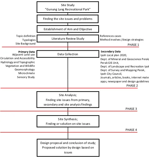
NUR MUHAMAD FIRDAUS 2015856844 9 1.7 Flow Chart
The data collection will be primary source for developing geo park of Gunung Lang Recreational Park. Also, information from secondary sources such as literature, geo rocks information, the stories of ancestors, the government planning as well as photographs, are related. The following flowchart is the method of information gathering undertaken in this study (Figure 1.0).
Primary Data Secondary Data
Site Study
“Gunung Lang Recreational Park”
Finding the site issues and problems
Establishment of Aim and Objective
Literature Review Study
Data Collection
Site Analysis;
Finding site issues from primary, secondary and site analysis findings
Site Synthesis;
Finding or solution on site issues
Design proposal and conclusion of study; Proposed solution by design based on
issues
Dept. of Mineral and Geoscience Perak, Perak GIS Unit,
Dept. of Landscape and Recreation Ipoh, Dept. of Survey and Mapping Perak, Ipoh City Council,
Journals, articles, books, internet materials, apps, newspaper and design guidelines. Adjacent Land use
NUR MUHAMAD FIRDAUS 2015856844 10 1.8 Significance of Study
In this study, the author want to highlight the importance of limestone hills and karst landscape. It is because, physical characteristics of the limestone makes it unique than other. Also it holds, a diversity of ecosystem for both animals and humans, besides balancing the surrounding temperature in term of shadow casting application in solar study. Similarly to other limestone hills in Ipoh, the major contributor for limestone hills degradation is rapid development. Rapid development includes urban development, agricultural activity and mineral extraction that have all contributed to degradation of limestone hills. If this difficulties continue untreated, it would cause a major loss to the unique diversity of limestone hills and the natural beauty of karst landscape. Also it would lead to geological disaster such as sink hole, land subsidence and limestone erosion.
NUR MUHAMAD FIRDAUS 2015856844 11 1.9 CHAPTER SUMMARY
NUR MUHAMAD FIRDAUS 2015856844 12 LITERATURE REVIEW AND RELATED REFERENCE CASES
2.0 INTRODUCTION
The purpose of this chapter is to encourage author with relevant studies and theories that are related with geological landscape approach which are implemented on geo site area. Also author will recognize, philosophies, principles, guidelines, approaches and strategies that are to be adapted into geo tourism perspective. Thus, the study will promote an understanding in order to achieve the aim and objectives of this study. This is because, the potential of site study can ease in term of design and also enable to identify successful reference cases on geo park area. Understanding the problems, solution and locality will help to ease this study. Finally, a comparative study between each reference cases will determine the best result and methods for geo the undertaking park area.
2.1 Evolution of Geo Park Worldwide
NUR MUHAMAD FIRDAUS 2015856844 13 2.1.1 UNESCO GLOBAL GEO PARKS (UGG)
UNESCO Global Geo parks are single, unified geographical areas where sites and landscapes of international geological significance are managed with a holistic concept of protection, education and sustainable development.
2.1.2 GLOBAL GEO PARKS NETWORKS (UGGN)
The Global Geo parks Network (GGN), of which membership is obligatory for UNESCO Global Geo parks, is a legally constituted not-for-profit organisation with an annual membership fee. The GGN was founded in 2004 and is a dynamic network where members are committed to work together and exchange ideas of best practise and join in common projects to raise the quality standards of all products and practises of a UNESCO Global Geo park.
While the GGN as a whole comes together every two years, it functions through the operation of regional networks, such as the European Geo parks Network
Figure 1.0: UGG logo.
Figure 1.1: GGN logo.
Source: www.unesco.org
NUR MUHAMAD FIRDAUS 2015856844 14
(EGN) and Asia Pacific Geo Park Network (APGN) that meets twice a year to develop and promote joint activities.
2.1.3 ASIA PACIFIC GEO PARK NETWORK (APGN)
APGN is established under Article 18 of The Global Geo parks Network (GGN) Statues as an Asia Pacific Region member for Regional Geo park Networks. Regional Geo Park Networks serve for the coordination of GGN activities at a regional or continental level and as fora for the exchange of information and co-operation between Global Geo parks and Global Geo park professionals in the region.
2.1.4 LEMBAH KINTA GEO PARK
Kinta Valley Geo park concept stipulates the source of heritage is not limited to geological heritage alone, but also biodiversity, archaeological, historical, artistic heritage, and even the heritage of the living. In this case, every citizen and all elements contained in the special area of Kinta Valley Geo Park and all the activities that take place are main component of Geo Park Kinta Valley and none should be set aside.
Based on research and survey by Department of Mineral and Geoscience (JMG) Perak on proposal development of Lembah Kinta Geo Park during 2015, the areas covers 2000 km2 widewith different administration authority such as Ipoh City Council (MBI), District office of Tanah Kampar and District office Tanah
NUR MUHAMAD FIRDAUS 2015856844 15 Batu Gajah. Also there were 20 sites that has been identified to fit the features to be Geo Park. Below are the potential site: -
1. Gua Khantan (Gua Khantan) 2. Mata Air Panas Lubuk Timah 3. Hutan Lipur Ulu Kinta 4. Jeram Papan
5. Lata Ulu Chepor 6. Gunung Karang Besar
7. Taman Rekreasi Gunung Lang 8. Gunung Datok
9. Gunung Tasek (Perak Tong) 10. Air Terjun Sg. Chelik 11. Gua Kandu
12. Air Terjun Salu 13. Gua Tempurung
14. Taman Rimba Klebang Saiong 15. Air Terjun Batu Berangkai 16. Jeram Sg. Kampar (Kg. Jahang) 17. Kapal Korek Tanjung Tualang 19. Gua Naga Mas (Gunung Pua) 19. Gua Tambun (Gunung Panajang) 20. Gua Kek Lok Tong (Gunung Rapat)
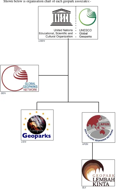
NUR MUHAMAD FIRDAUS 2015856844 17 Shown below is organisation chart of each geopark associates:-
Figure 1.4: Organisation chart of Geopark associates. Source: author. UGN
APGN
GLK GGN
NUR MUHAMAD FIRDAUS 2015856844 18 2.2 Geo Park Perspective in Malaysia.
In Malaysia, Geo Park initiative was implemented during the 2000, unfortunately there were lack of technologies and resources. Although in 2006, Chairman of LADA, Dato Kamarulzaman Abdul Ghani believed that Geo Park industry can lead Langkawi to become international tourist destination. The development of Geo Park ideas lead by Kumpulan Warisan Geologi, UKM; Kementerian Kewangan Malaysia; and Kerajaan Negeri Kedah (IBK, 2017). On 1st June, 2007, Malaysia has officially become a member of the 52th Global Network of National Geo parks which thus recognizes Langkawi as one of the geo park sites in the world. Located in northern Peninsular Malaysia in the state of Kedah, it is formed by the combination of 99 magical islands that adds the uniqueness to Langkawi Archipelago. The total area of the Langkawi Geo Park is about 478 km2, (Malaysian National Commission for UNESCO). However, there are 13 to 14 geo site areas that have the potential to be developed as Geo Park, including Lembah Kinta, Tasik Kenyir, Gunung Kinabalu, and Delta Sarawak.
2.2.1 LEMBAH KINTA
The Kinta Valley in Perak is rich in unique karst hills that have a variety of heritage value, mining geology and diversity of landscapes. Most of these karst hills are located in Ipoh and it is a package to make the city of Ipoh capable of promoting among local and international tourists within geo tourism.
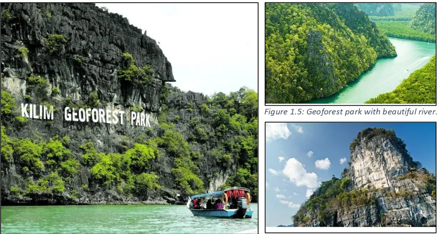
Figure 1.6: Kilim Geoforest Park signage.
Figure 1.5: Geoforest park with beautiful river.
NUR MUHAMAD FIRDAUS 2015856844 19 The Kinta Valley also has mass resources of geological heritage and cultural heritage that satisfy most of the requirements for being entitled at least as a national geo park. The Kinta Valley is renowned for its tin mining site and has a unique diversity of natural landscapes and high geological and scientific historical value.
2.2.2 HISTORY OF LEMBAH KINTA
The history of the Kinta Valley is said to begun not less than 1,500 years ago based on the discovery of Buddhist relics from the Srivijaya era in Tanjung Rambutan (1893) and Lahat (1931) which were planted 10 ft. in the ground. At that point, Kinta was the centre of land route between the Malay kingdom of Srivijaya Buddha’s in Palembang with the Malay kingdom of Buddha Khmer and Campha in Indo-China.
The Kinta Valley is also regarded as the centre of the first Gangga state administration before Beruas and this discovery is said to be delayed as Kinta has been destroyed due to the failure of the miner that demolish of the natural landform for the tin resources.
2.2.3 GEOLOGY LEMBAH KINTA
The Kinta Valley area is a lowland formed by limestone and a small part of the sycamore. Nearly 80% of the Kinta Valley area is based on limestone layers with some appearing on the surface of an upright hill or hill called the topographic bar. Kinta Valley is also surrounded by 2 rocky granite rocks that are Kledang Range in the west and Titiwangsa Range in the east.
NUR MUHAMAD FIRDAUS 2015856844 20 In general, the Kinta Valley consists of granite rocks and metaphorical rocks from the Calcareous Series with reference to the Kinta Valley map by Ingham and Bradford (1960). The metasedimen rocks of the Calcareous Series form the base layer of the Kinta Valley and comprise two falsies, namely limestone falsies and argillic falsies. The limestone rock is the dominant rock that forms the limestone falsies. The argillic falsies are composed with shale, filit and quartz alternate with limestone falcies (Ingham and Bradford, 1960). According to (Ingham and Bradford 1960), in 1956 and 1959 graptolites were found in Kanthan and Chemor from aged from middle Ordivision to Silur. Suntharalingam (1966) also had found a fossil aged Devon Down to middle Perm in Kampar. Based on this limited fossil discovery, Ingham and Bradford (1960) have given the age of the Lower Carbon to the base of the Kinta Valley.
Granite rocks in the Kinta Valley are formed by two granitoid ranges of Kledang Range (3,469 ft.) to the west and Titiwangsa Range (7175 ft.) to the east. Ingham and Bradford (1960) gave Trias age while Hutchison (1973) reported that granite in the Kinta Valley had a range of age between the Central Trias and the Final Jura. In the Kinta Valley alluvium deposits are the most important deposits because they are the major source of tin ore production. These alluvium sediments are divided into Old Age Old Pleistocene and Young Aluvium Resen are found unincorporated on the symmetry and marble.
Figure 2.0: View towards Titiwangsa range from Kledang hill
NUR MUHAMAD FIRDAUS 2015856844 21 2.3 IMPORTANCE OF GEOPARK ESTABLISMENT
The Geo park idea underscores the importance of raising the socio-economic status of citizens by taking into account the inherent advantages of heritage treasures, including through industry:
i. TOURISM
Developing a sustainable tourism industry and introducing the geo tourism sector by injecting geoscience elements in existing nature tourism and recreational activities and opening a new Geo tourism site. Geo tourism not only guarantees economic return but also supports the conservation and enhancement of human capital.
ii. TOURISM SUPPORT
The tourism industry has vast opportunities for the growth of various other supporting industries including accommodation services (resorts, hotels, homestays, campsites, etc.) transport, culinary and production of souvenir products. Geopark Ideas advocates a unique initiative in producing local products that can be used as the identity of a region as a geo park product.
iii. PRESERVATION
Geo park member can be involved as ranger and volunteer who will be responsible for monitoring activities on a geo tourism site.
iv. RESEARCH AND DEVELOPMENT
Increased tourism activities led to the need for scientific research to increase scientific value and determine the attractiveness of a tourism site. Socio-economic studies are also important in making short and long term development plans.
v. EDUCATION
NUR MUHAMAD FIRDAUS 2015856844 22 2.3.1 PRINCIPLE IN GEO PARK DEVELOPMENT
Based on literature review from Ibrahim Komoo, Geopark as a Model for Regional Sustainable Development, 2010. He has highlighted two main component in development of Geo Park:
i. Contains geological heritage sites that have important in the international level this source is the basis of formation geo park
ii. Biological heritage and culture site, especially when it has a close relationship with geology and landscape.
Besides that, the GGN has published guideline and criteria that determine a successful geo park. The following six criteria are:
i. To be an area with clearly defined boundaries that includes not only many geological heritages showing the intelligible geologic history of and phenomena in the region, but also sites of archaeological,
ecological, or cultural value
ii. To have the steady governing structure by a public institution, local community, and private entity and to have administrative and financial plans
iii. To foster the sustainable society and economic development in the region through geo tourism and other measures
iv. To conduct education and promulgation activities on earth sciences and environmental problems through museums, natural observation paths, and guided tours
NUR MUHAMAD FIRDAUS 2015856844 23 vi. To interchange information reciprocally as a member of the GGN, to
participate in conferences, and to proactively activate the network.
2.3.2 RELEVENT AUTHORITIES RELATED TO DEVELOPMENT OF GEO PARK
Shown below are authorities related to development of Geo Park:
UNESCO
Jabatan Mineral dan Geosains Malaysia
Jabatan Perancangan Bandar dan Desa Semenanjung Malaysia
Majlis Perbandaran Negeri
Jabatan Ukur dan Pemetaan Malaysia
Jabatan Perlindungan Hidupan Liar dan Taman Negara Semenanjung Malaysia
Kementerian Pelancongan dan Budaya Malaysia.
Pejabat Tanah Daerah
Kerajaan Negeri
Jabatan Landskap Negara
Below are the laws and act that relevant to development of Geo Park:
Akta Kualiti Alam Sekililing (1974)
Akta Warisan Kebangsaan (2005)
Kanun Tanah Negara (1965)
Akta Perhutanan Negara (1984)
Akta Pemuliharaan Hidupan Liar (2010)
Rancangan Tempatan Daerah Ipoh (2020)
Garis Panduan Pengkelasan Cerun Bukit Batu Kapur dan Zon selamat (1999)
Garis Panduan Kawasan Simpanan Mineral dan Bencana Geologi(2011).
NUR MUHAMAD FIRDAUS 2015856844 24 2.4 REFERENCE CASES
2.4 Gunung Keriang Recreational Park: REFERENCE CASES 1 2.4.1 Site Background
The Gunung Keriang area is about 10 km north of the city of Alor Setar is the only one of the moss-shaped limestone hills found in the urban area. This hill is characterized by its large size, high position and a beautiful landscape surrounded by vast paddy fields. In terms of geological information of Gunung Keriang Mountain it consists of a sequence of limestone layers called chuping formation or ‘Kediang’ formation. The limestone sequence is the same as that found in the hillside around the area. This limestone series is a sedimentary sequence of shallow oceanic sediments around 260 to 225 million years ago (the period of Perm to late Trias)
The 'Gua Terus' is located inside Gunung Keriang. The entrance to the 'Gua Terus' is very beautiful and has a very panoramic view to immortalize as part of the country's geo-cultural treasures. The cave actually consists of three floors but has collapsed due to the work of knocking and taking calcite minerals. The 'Gua Terus' is the longest cave in Kedah, which is 600m long, features interesting features such as stalactites, stalagmites, flow stones and calcite crystals. There was a clash of winds in the midst of a very comfortable cave and soothing the minds of the Gua Terus.
NUR MUHAMAD FIRDAUS 2015856844 25 2.4.2 Aim of Gunung Keriang Recreational Park.
Department of Minerals and Geoscience Kedah/ Perlis/ P. Pinang (JMG KPP) has conducted the Gunung Keriang Expedition in January 2015 to jointly see the beauty of the Gua Terus. This rugged activity was attended by 40 JMG KPP members along with seven local press and media representatives. The result of this expedition we have been able to experience the magic of Gua Terus to be shared as part of open information for fans of this cave. Explore this cave is dangerous because at this time there are no facilities such as ladders, lights and ropes to help facilitate exploration. JMG KPP has been working to set up and install the Kedah Geoheritage. Site panel of Gunung Keriang, Alor Setar for the public information. Related panels can be viewed at Mount Keriang Recreation Park (North) and also near the lift in the southern part of Mount Keriang.
2.4.3 Issues and Problems
Virtually, the geo-site does not have protection and this lead to partial loss physical damage effected by the massive quarrying.
Poor governance results in bad policy formulation, management, and enforcement, and this can become apparent through problems with environmental sustainability at the geo-site.
Figure 2.4: Entrance of Gunung Keriang Recreational Park
NUR MUHAMAD FIRDAUS 2015856844 26 Neglecting the unique characteristic of Gunung Keriang
geological formation.
2.4.4 Design approach and solution
o Develop Ecological Restoration Strategy to prevent any unplanned development within vicinity of Gunung Keriang Recreational Park
o Connection to Gua Keriang which enable user to experience natural
karst landscape.
o Programs activity planning by local authority and JMG to attract
NUR MUHAMAD FIRDAUS 2015856844 27 2.5 Miri Airport Road Outcrop Museum: REFERENCE CASES 2
2.5.1 Site Background
Miri was the initial oil town in Malaysia. The oil well produced oil for 62 years until it was stopped in 1972.The development of the oil industry has helped to transform Miri from a small fishing village at the turn of the century into a modern and wealthy town with 170 000 residents, comprising various ethnic backgrounds.
The key significance of the Miri Airport Road Outcrop lies in its scientific value in that a well-preserved faulted sedimentary rock sequence provides a data of the geological and tectonic history of the area back fifteen million years ago. The faults and associated deformation features can be detected in three dimensions, thus making the site one of the best outcrops of its kind in Malaysia. Many remarkable deformation structures associated with the faults can also be saw, including fault gouge, fault bed, fault lens, fault end and drag of bedding.
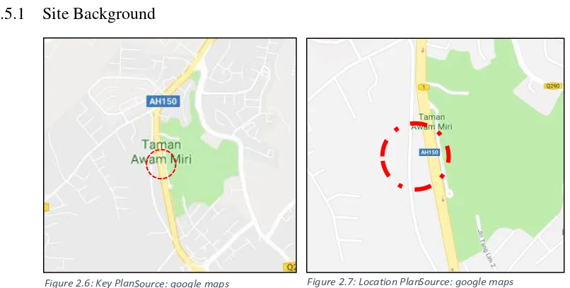
Figure 2.6: Key Plan Source: google maps Figure 2.7: Location Plan Source: google maps
NUR MUHAMAD FIRDAUS 2015856844 28 2.5.2 Aim of Miri Outcrop Museum
The initial was to develop interesting outcrops, and particularly those that are accessible along the roadside, in order to create and develop interest among the people of Miri.
2.5.3 Issues and Problems
o People of Miri are not interested in geology awareness o The authority has no plan to develop the area in the future. o Lack of social activity
2.5.4 Design approach and solution
o Pedestrian and guides trail to facilitate movement an increase safety
around the site.
o Informative signage to support geology information.
NUR MUHAMAD FIRDAUS 2015856844 29 2.6 Comparison between Reference Cases
The reference cases above are selected based on the scope of landscape karst study. Besides, different reference cases have different strength in term of design strategy, model adaptation and design solution.
Site Context
Miri Airport Road Outcrop Museum,
Sarawak.
geological and tectonic history of the
area dating back fifteen million years.
Local awareness and interest in
geology is not that high among the
people of Miri
Virtually, the geo-site does not have protection and poor
governance results in bad policy problems with environmental sustainability at the geo-site. Also neglecting the unique
characteristic of mount Keriang geological formation
Aim Of
Project
To develop interesting outcrops, and
particularly those that are accessible
along the roadside, in order to create
and develop interest among the
there are no facilities such as ladders,
lights and ropes to help facilitate
exploration.
Design
Strategy
Information of site, paths and
guide-rails, and guided expeditions
Ecological Restoration Strategy
Connection to Gua Keriang.
Programs activity planning by local
authority and JMG to attract tourist to
Gunung Keriang Recreatinal Park
Table 2.0: Comparison study between each reference cases
Source: author
NUR MUHAMAD FIRDAUS 2015856844 30 2.7 CHAPTER SUMMARY
NUR MUHAMAD FIRDAUS 2015856844 31 SITE INVENTORY AND ANALYSIS
3.0 INTRODUCTION
In this chapter, the content will be focusing on the study area that is being investigated. The main objective of this process is to gather information through inventories and to interpret them in the form of analysis which will be synthesized into solutions. It is concisely presented and explained in the form of images, section-elevations, sketches complemented by description. The content will be explained on the background, environmental, physical, and social-cultures of the study area and project area that involved with existing condition, problems and issues, potential and opportunities. To get a clear understanding of the site, this process will be divided into two major components which is macro context (Gunung Lang and Gunung Bilike-Study Area) and micro context (Gunung Lang Recreational Park – Project Area). The whole process will be used as a guide to find an applicable method that will be adapted into the design proposal. located in the middle of the Kinta Valley. It can be accessed via the North-South Expressway through the exit of Sungai Siput and Jalan Kuala Kangsar. It is a 12 minutes ride from Ipoh railway station and Ipoh central bus station.
NUR MUHAMAD FIRDAUS 2015856844 32 3.1.2 SITE BACKGROUND
Gunung Lang and Gunung Bilike are based on the formation of ‘Batu Kapur Kinta’ consisting of limestone and schist (quartz-mica). The area of limestone hills found in this area was explored by tin ore miners as early as 1880 where active mining was carried out in the caves found in this area. The limestone gypsum that had been converted into marble stone in the area was also exploited as quarrying resources. Quarrying activities result changes in the geological structure of the soil and the terrain in the mountain area.
Gunung Lang
Gunung Bilike
Plan 2.0: Demarcation of Gunung Lang, Gunung Bilike and Gunung Lang Recreational Park. Source: Author Gunung Lang
NUR MUHAMAD FIRDAUS 2015856844 33 The thickness of this rock coating is between 4 cm to 130 cm. There are two main type of rocks in this area, namely limestone and marble. Limestone is in gray to yellowish in color, whereas marble is in milky white to grayscale in color.
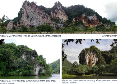
Figure 3.2: Panoramic view of Gunung Lang Karst Landscape. Source: author
Figure 3.3: View towards Gunung Bilike from jetty area. Figure 3.4: View towards Gunung Bilike from park area.
NUR MUHAMAD FIRDAUS 2015856844 34 3.2 GUNUNG LANG RECREATIONAL PARK - MICRO
3.2.1 Site Background
Gunung Lang
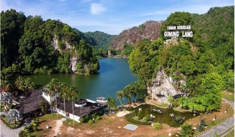
Recreational Park is a popular recreational park in the northern city of Ipoh. It was built around a scenic backdrop of magnificent limestone hills of Gunung Lang and Gunung Bilik. The total area of the park is 30.35 hectares and the lake area is 15.16 hectares. Gunung Lang Recreational Park was officially opened in 1999 as one of the city council's initiatives to conserve the remains of tin mining and marine quarries.
Plan2.1: Site Plan.
NUR MUHAMAD FIRDAUS 2015856844 35 The valley, most of which have been mined since the late nineteenth century turned into an ore mining area which developed a disrupted landscape area such as the swampy areas and lakes. Gunung Lang Recreational Parks consist of three man-made lakes which were former mining pools. Gunung Lang consists of diversity of flora and fauna species where fish such as talipia, kelah, lampam, kap and catfish can be found in the lakes. Besides, there are also flowers such as bougainvillea, lobster-claws and ‘bunga pisang’.Visitors can enjoy outdoor activities and water sport in the lakes. The Department of Recreation and Landscape Ipoh is also located here.
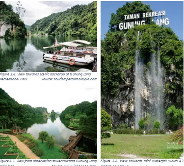
Figure 3.6: View towards scenic backdrop of Gunung Lang Recreational Park.
Figure 3.7: View from observation tower towards Gunung Lang main lake. Source: www.ipohecho.com
NUR MUHAMAD FIRDAUS 2015856844 36 3.3 LAND USE AND ACTIVITIES
3.3.1 Development Zone
According to “Rancantangan Tempatan Daerah Ipoh 2020” , Gunung Lang Recreational Park was included in ‘Blok Perancangan 6’ (BP 6),sub -development (BP 6.3) and covers the area from Lahat- Menglembu – Buntong- Jelapang – Meru. It covers an area of 6,878.20 hectares and managed by Ipoh State Municipal (MBI). recreation zone because the Gunung Lang Recreational Park itself covers 111.91 hectares. Whereas the industrial, housing and farming zone have the same percentage. The smallest zone is commercial zone
Source: RTD Ipoh 2020
Plan 2.2: Key Plan of development in Ipoh. Table 3.0: Citizens density for development block 6. Source: RTD Ipoh 2020
NUR MUHAMAD FIRDAUS 2015856844 37 because most of the commercial areas were developed in city center.At the west of the Gunung Lang, the area consists of major zones like industrial and housing. However the east of Gunung Lang is dominated by open space and green space zone.
3.3.3 Listed below are the zone s found at Gunung Lang Recreational Park area. I. Water Bodies Zone
The water bodies consist of Gunung Lang pond and lake. Also Kinta and Pari River and Gunung Lang groundwater
II. Open Space and Green Space Zone
The open space consist of Gunung Lang Recreational Park, playground and parking space. Also green space consist of wide open land and buffer zone.
Figure 3.9: Swamp/pond. Figure 4.0: Groundwater of Gunung Lang.
Figure 4.3: Playground area in GLRP. Figure 4.4: Parking space at GLRP.
Figure 4.1: Cat fish pond. Figure 4.2: Main lake of Gunung Lang Recreational Park.
Source: author Source: author
Source: author Source: author
NUR MUHAMAD FIRDAUS 2015856844 38 III. Forest Reserve Zone
The forest reserve zone consist of ‘Hutan Bukit Batu Kapur’ in Gunung Lang
IV. Transportation Zone
The transportation zone consists of Kuala Kangsar road, Persiaran Gunung Lang. PLUS highway (North-East Expressway) and Ipoh railway route (Ipoh-KL ETS route).
Figure 4.5: View towards Limestone hills forest reserve of Gunung Lang.
Figure 4.6: Persiaran Gunung Lang. Figure 4.7: Kuala Kangsar road.
Figure 4.8: South-North Highway.
Source: author
Source: author Source: Google Streets
NUR MUHAMAD FIRDAUS 2015856844 39 V. Housing Zone
The housing zone consist of medium and low terrace house and government quarters.
VI. Industrial Zone
The industrial zone consists of small industry like workshop and machineries, suppliers.
VII. Commercial Zone
The commercial zone consists of shop houses, restaurant, plant nurseries, cars dealer, store, and stalls.
Figure 4.9: Medium terrace house. Figure 5.0: Government quarters.
Figure 5.1: Small factory machineries. Figure 5.2: Workshop and garage.
Figure 5.3: Terraces shop houses. Figure 5.4: Plant Nurseries.
Source: author Source: author
Source: author
Source: Google Streets Source: Google Streets
NUR MUHAMAD FIRDAUS 2015856844 40 VIII. Amenities Zone
The amenities zone consist of electric line station, TNB Sub station and water tank.
IX. Facilities Zone
The facilities consist of temple, mosque, petrol station, school, cemetery, playground, clinic, and bus stop.
3.3.4 Land used activities
The land used activities are derived from the land used zone and most of the activities benefit each other. The activities are:-
Zone Activity
Water body Fishing, kayaking ,photograph Open Space Strolling, meeting point, social space Transportation Cab services, bus services, route
Commercial Buying, selling, and business
Housing Community settlement
Industrial Repairing, loading, and supplying
Figure 5.5: TNB sub station near commercial area. Figure 5.6: Electric line tower.
Figure 5.7: Buddha temple. Figure 5.8: Petrol Station.
Table 4.0: Activity related to land use. Source: author
Source: Google Streets Source: author
NUR MUHAMAD FIRDAUS 2015856844 41 3.4 ACCESSIBILITY AND CIRCULATION
3.4.1 ACCESSIBILITY (Macro Scale)
The accessibility to Gunung Lang Recreational Park can be access from South East Expressway, Kuala Kangsar road and ‘Persiaran Gunung Lang’. However 70% of user used their private vehicles, another 20% are private bus, taxi and tourist minivan also another 10% are motorcycle.
Legend
North South Expressway Kuala Kangsar road Persiaran Gunung Lang Railway
Site Boundary Gunung Lang
Recreational Park
Gunung Bilike
Gunung Lang
NUR MUHAMAD FIRDAUS 2015856844 42 3.4.2 CIRCULATION
There are two types of circulation pattern in Gunung Lang Recreational Park which is vehicular and pedestrian. Both serve the purpose of providing linkage and demarcation for Gunung Lang and its vicinity.
Vehicular circulation
There are several roads that connect to Gunung Lang Recreational Park. They are categorized into 3 types which is freeway, primary road, secondary road and waterways. The vehicular road used asphalt for the entryway, main frontage and exit.
3.4.2.1 TYPOLOGY OF ROAD
i. Freeway – North South Expressway
The North South Expressway consists of 8 lanes and one way, the middle 4 lanes are access to north and southern region of Malaysia. Between that, the 4 lanes can access to nearest streets and Ipoh city center. The total width of the lanes is 50 meters.
ii. Arterial/Primary – Kuala Kangsar Road
This route can access to Ipoh city center and Sg. Siput area. This roads consist of 6 lanes and two ways which divided by 2 meters width of island. The road have moderate congestion during peak hour on work, lunch and off hour. The total width of the lanes is 25 meters. (Refer figure)
NUR MUHAMAD FIRDAUS 2015856844 43 iii. Collector/Secondary – Persiaran Gunung Lang
This route can access to smaller street within the vicinity of Gunung Lang area and it consist of 4 lanes and 2 ways which are divided by 3 meters width of green island. The roads have low congestion during peak hours. The total width of the lanes is 17 meters.
Source: Google Earth Figure 6.0: Kuala Kangsar road.
NUR MUHAMAD FIRDAUS 2015856844 44 3.4.3 TRAFFIC FLOW
The traffic flow at Gunung Lang Recreational Park were even because low numbers of car and motorist even though during peak hour and weekend.
Legend
The waterways in Gunung Lang Recreational Park was used to transport visitor from jetty area to the island area via tourist boat. The length of the route is 300 meters and estimated time is 15 minutes. The boats were used to operate during weekday and weekend. The small boat can carry 10-12 passengers and the medium boat carry 18-23 passengers.
Plan 2.5: Vehicular traffic flow.
NUR MUHAMAD FIRDAUS 2015856844 45 Legend
Jetty 1 Jetty 2 Entry Tour Exit Tour
Gunung Lang Recreational Park jetties is in perfect condition, thus the boat tourist service are quite slow during weekend because of high demand.
Plan 2.6: Tourist boat flow.
Gunung Lang
Gunung Bilike Lake
Source: author
Figure 6.2: Jetty 2 at island area.
Figure 6.3: Jetty 1 at entrance area.
Source: author
NUR MUHAMAD FIRDAUS 2015856844 46 The condition and services of tourist boat were in good condition. From the boat ride activity, soil erosion occurred at some part of the park.
Figure 6.4: Lang 1 – Medium boat (18 -23 passenger).
Figure 6.5: Lang 2 and 3 – Small boat (8-12 passenger).
Figure 6.6: Soil erosion due to boat ride activity and loose soil structure.
Source: author
Source: author
NUR MUHAMAD FIRDAUS 2015856844 47 3.4.5 PEDESTRIAN CIRCULATION
There are several tertiary road in Gunung Lang Recreational Park and its vicinity which are differentiated in 3 types which is footpath, cow path and boulevard. The materials used for the entryway, jetty and park area are different
Legend
Footpath Cowpath
Hotspot area / view
Legend
Footpath Cowpath Boulevard Decking path Hotspot area / view
Plan 2.7: Pedestrian flow at Jetty area.
Plan 2.8: Pedestrian flow at island area.
Source: author
NUR MUHAMAD FIRDAUS 2015856844 48 3.4.5.1 TYPOLOGY OF PATH
a) Footpath
The footpath linkages are located at the entrance of the Landscape and Recreation Department building, ‘Laman Perak’, jetty, and island area. The width of the footpath varies within the specific area and the material also varies from asphalt, pebble wash, concrete imprint and fiber. Most of the footpath are in good condition, however there are some footpath area are not well placed and some of it have crack which can harm the users.
Figure 6.7: 12 meter wide asphalt footpath around Gunung Lang Recreational Park are in good condition.
Figure 6.8: Building frontage of Ipoh Landscape and Recreation Department made by concrete and pebble wash finishing.
Figure 6.9: ‘Laman Perak’ walkway are varies in materials and are 2 meters wide.
Figure 7.0: 3 meter wide of fiber-like-wooden walkway at island area that give connection to playground area.
Figure 7.1: 3 meter wide of concrete imprint walkway throughout the island area.
Figure 7.2: 5 meter wide of asphalt road at the island area. This man made cave access were used for maintenance and emergency purposes.
Source: author Source: author
Source: author Source: author
Source: author
NUR MUHAMAD FIRDAUS 2015856844 49 b) Boulevard
The boulevards mostly were located at the island area having 5 meters width and 200 meters of length. The materials used were concrete imprint.
c) Cow path
The cow path linkages are based on the human behavior that tend to take the nearest path to the desired destination. Most of the cow path are scattered around the park. It is mostly scattered at the parking area, man-made waterfall area, ‘Laman Perak’ and playground area. The cow paths in the park that are unpaved are less attractive to the users.
Figure 7.4: 3 meter wide of concrete walkway near the exit of island area was in good condition.
Figure 7.3: One of the concrete imprint walkway were damage from the uprooting of Samanea Saman trees.
Figure 7.6: View towards the heritage plaza archway from boulevard direction.
Figure 7.5: View towards the observation tower from heritage plaza. The condition of the boulevard are in great condition.
Figure 7.7: Unpaved path to man-made waterfall area which lack of physical linkage.
Figure 7.8: Unpaved path to resting area at ‘Laman Perak’.
Source: author Source: author
Source: author Source: author
NUR MUHAMAD FIRDAUS 2015856844 50 3.4.6 PEDESTRIAN FLOW
The rate pedestrian flows vary according to the climate, point of interest and accessible to the destination. However the flow during weekdays are low in human movement, whereas during weekend the flow occurred from moderate to high during peak hour. The hotspot areas are mostly centered to jetty, man-made waterfall, playground areas, mini zoo, heritage plaza, mural wall, observation tower and natural limestone wall.
a) Hotspot at entrance area.
Figure 8.1: View towards man-made waterfall. During peak hour, this spot become crowded with visitor and activity.
Figure 8.3: Tourist waiting for their boat ride at Jetty near to cascading waterfall.
Figure 8.4: Natural limestone wall and lake near exit of the park.
Figure 8.2: Playground area for children in front of Jetty building equipped with resting area. Figure 7.9: Cow path from the parking to the playground
area.
Figure 8.0: Cow path from the parking to the man-made waterfall.
Source: author Source: author
Source: author Source: author
Source: author
NUR MUHAMAD FIRDAUS 2015856844 51 b) Hotspot at island area.
Figure 8.7: Malay traditional house architecture at heritage plaza at island area.
Figure 8.5: Attractive mural wall with seating equipment are the stop by for visitors to take picture.
Figure 8.9: Observation Tower give a glance view of the island area and create an attraction to visitors.
Figure 9.0: The decking pathway is a spot for tourist to feed monkey and fish beside act as a linkage to playground area. Figure 8.6: Dinosaur theme playground give attraction to family and children at island area.
Figure 8.8: View towards mini-zoo. During peak hour, this spot become crowded with visitor and activity.
Figure 9.1: Man-made cave give attraction to visitor to experience cave features like stalactite and stalagmite.
Source: author Source: author
Source: author Source: author
NUR MUHAMAD FIRDAUS 2015856844 52 3.5 TOPOGRAPHY AND HYDROLOGY.
3.5.1 ‘Kawasan Sensitif Alam Sekitar’ (KSAS)
Environmental Sensitive Areas (KSAS) is a necessary area given special attention or reasonable consideration before development is allowed in the area or nearby area, where improper development will affect the value of life support, biological diversity or pose a potential risk of disasters. Based on Local Plan Studies (RT) Ipoh 2020 has outlined the cluster area covering 111.93 hectares Gunung Lang and Gunung Bilik as Environmentally Sensitive Areas (KSAS) Phase 2 and should be preserved.
Below are the criteria why Gunung Lang and Gunung Bilik were classified as the KSAS area:-
Plan 2.9: KSAS Plan of Ipoh. Source: RTD Ipoh 2020.
NUR MUHAMAD FIRDAUS 2015856844 53 Hence, only activities such as low-impact ecotourism, research and education are justified. Activities such as agriculture and development are not permitted while logging activities are allowed on a small scale with approval and monitoring from the Forest Department.
3.5.2 Demarcation of Safety Zones in the Vicinity of Limestone Hills. 3.5.2.1 Safety Zone Gunung Lang and Gunung Bilike areas
The safety zone of Gunung Lang and Gunung Bilike varies from its physical character such as heights, form, and slope percentage. Limestone element consist from Calcium Carbonate (CaCO3) which can be affected from chemical and physical reaction, especially on water. This is because this elements are moderate soluble to water. From this reaction, presence of structural cracks, scraping slopes and the overhang realizing the state of rock blocks has the potential to fail.
Figure 9.2: Part of Gunung Bilike limestone hills safety. zones.
Figure 9.3: Visible undercut can be seen at the foothill of Gunung Bilike which consider it as very high hazards rating.
Figure 9.4: Non-visible undercut can be seen at the foothill of Gunung Bilike which consider it as
high hazards rating.
View 1 View 2
View 1
View 2
Source: Author