ISSN 0024-9521
IJG Vol. 46, No.2, December 2014 (138 - 142) © 2014 Faculty of Geography UGM and The Indonesian Geographers Association
Impacts of land cover change on climate trend in Padang Indonesia
Dedi Hermon
Received: 11 05 2014 / Accepted: 01 09 2014 / Published online: 31 12 2014 © 2014 Faculty of Geography UGM and The Indonesian Geographers Association
Abstract The purpose of this study was to analyze the trend of climate change through changes in the elements of Green House Gases (GHGs), includes the trend of CO2, N2O, and CH4. The change of the extreme rainfall and temperature indices due to land cover change into developed area in Padang. Identification and analysis trends of climate change and extreme climatic events were analyzed by using RclimDex the Expert Team for Climate Change Detection and Indices (ETCCDMI) technique. Where as the analysis and interpretation of land cover changes into developed area used Landsat TM 5 and Landsat 1985 7 ETM + of 2011 by ERDAS 9.2 GIS with the supervised classification method and GIS Matrix. The results of the study provide informations of land cover changes into developed area at forest land (11,758.9 ha), shrub (3,337.3 ha), rice fields (5,977.1 ha), and garden (5,872.4 ha). It has an implication on increasing of the ele-ments of GHGs concentration such as CO2 (14,1 ppm), N2O (5,4 ppb) and CH4 (24,8 ppb). This condition lead to an extreme temperature and presipitation indexs trends in Padang.
Abstrak Tujuan penelitian ini adalah menganalisis trend perubahan iklim melalui perubahan unsur-unsur Gas Rumah
kaca (GRK) yang meliputi trend CO2, N2O, dan CH4, serta indeks temperatur dan curah hujan ekstrim akibat perubahan tutupan lahan menjadi lahan terbangun di Kota Padang. Identifikasi dan analisis trend perubahan iklim dan kejadian-kejadian iklim ekstrim di analisis dengan menggunakan metode RclimDex dengan teknik Expert Team for Climate Change Detection and Indices (ETCCDMI), sedangkan analisis perubahan tutupan lahan menjadi lahan terbangun dilakukan dengan interpretasi Citra Landsat TM+5 tahun 1985 dan Citra Landsat ETM+7 tahun 2011 dengan GIS ERDAS 9.2 den-gan metode supervised classification dan GIS Matrix. Hasil penelitian memberikan informasi perubahan tutupan lahan menjadi lahan terbangun yang cukup ekstrim terjadi pada lahan hutan (11.758,9 ha), semak (3.337,3 ha), sawah (5.977,1 ha), dan kebun (5.872,4 ha). Kondisi ini mengakibatkan trend yang meningkat dari CO2 sebesar 14,1 ppm, N2O mening-kat sebesar 5,4 ppb, dan CH4 meningmening-kat sebesar 24,8 ppb. Hal ini secara langsung mengakibatkan terjadinya trend indeks temperatur ekstrim dan curah hujan ekstrim di Kota Padang.
Keywords: Climate Change; Green House Gases; Land Cover Changes
Kata kunci: Perubahan Iklim, Gas Rumah Kaca, Perubahan Tutupan Lahan
Land cover change is an urban development phenomenon that is difficult to solve. This is due to the urban development which directly change natural land functions. In line with the urban development caused the pressure on forest land conversion into developed area. The land cover changes will lead to the increasing of CO2 concentration in the atmosphere. The changes in agricultural and farm land into developed area will produce an increasing trend of N2O and NH4. That would affect the changes of climatic conditions in the region directly [Hermon, 2012a]. CO2, N2O, and NH4 are included in green house gas (GHG) which naturally can adsorb the heat radiation in the atmosphere. The change in GHGs concentration will impact unstable
Dedi Hermon
Geography Department and Graduate Programe of Padang State University
Email: [email protected]
climatic conditions both on extreme temperature and rainfall. GHG emissions have been increasing due to the increased of fossil fuels (FF) consumption since the industrial revolution in the mid 1980s. In the last decade, CH4 emissions have declined by 22 million tons/
year from 37 million tons/year in the previous decade and N2O emissions also decreased slightly from 3,9 to
3.8 million tons/year. The CO2 emissions increased by
more than double from 1.400 million tons/year to 2.900 million tones/year. It had an implication on temperature rising by 0.50 Co compare to pre industrial. In the long
term, earth temperature will tend to be higher than the current temperature [IPCC, 2001; Hermon, 2010].
Padang is the capital city of West Sumatra Province. that has a flat to hilly relief in general, primary forest located on the eastern and southern city. It continues over the time. Land cover change into developed area covered 3,044.20 ha in 1980 and increased to 8,288.28
IMPACTS OF LAND COVER CHANGE Dedi Hermon
139
ha in 1995, 12,444.21 ha in 2005 compared to 69,496 ha of Padang area [BPS Padang, 1981; BPS Padang, 1995; BPS Padang, 2006]. Land cover changes into developed area generally occur in the Lubuk Kilangan, Bungus Teluk Kabung, Koto Tangah, and Padang Selatan district. Those are belong to the hills with forest vegetation [Hermon, 2009; Hermon, 2012a; Hermon, 2012b]. The objectives of this study was is to analyze the climate trend caused by land cover changes in Padang.
2. The Methods
According to Zain [2002], Hermon [2009], and Hermon [2012b], the dynamics of land cover changes into developed area by interpretation of Landsat TM + 5 (1985) and Landsat ETM + 7 (2011) using ERDAS 9.2 as analysis tools. The analysis of land cover classification used supervised classification techniques on each images. This formulated six patterns of landcover, ie: (1) forest, (2) garden, (3) shrub, (4) open land, (5) paddy field, and (6) developed area. The analysis of area change (ha) for each land cover in 1985 and 2011 used ERDAS 8.6 and tools Interpreter (GIS Analysis-Matrix). Rclimdex with Expert Team for Climate Change Detection and Indices (ETCCDMI) technique had used for climate change and climatic extreme events.
3. Result and Discussion
The result of Landsat 5 TM + (1985) and Landsat ETM + 7 (2011) shows that land cover changes into developed area had an increasing trend. The Increasing trend of land cover change into developed land generally occurs in the eastern part of Padang. The area was converted from forest, gardens, shrubs, and rice paddies into developed area (Table 1).
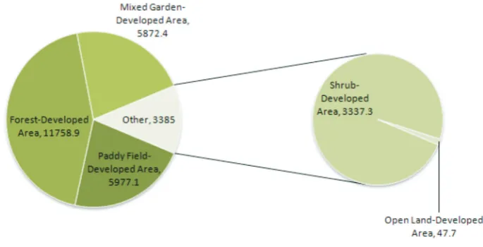
Forest land, shrub, paddy field and mixed garden had changed into developed area. The change of forest land into developed area during 1985 – 2011 reached 11.758,9 ha while paddy field changes into-developed land area as much as 5.977,1 ha. The changes of garden into developed area was 5.872,4 ha and shrub land
changes is 3.337,3 ha (Figure 1).
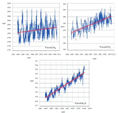
The land cover changes leads to increading trend of GHG concentration for CO2, N2O, and NH4. It will impact the change in temperature and rainfall patterns in Padang. The concentrate of CO2, N2O, and NH4 from 1985 to 2011 showed an increasing trend. The concentrate of CO2 increased by 14.1 ppm, N2O increased by 5.4 ppb, and CH4 increased by 24.8 ppb. Nahas and Setiawan [2009] explained that the increase of CO2 concentrate in the air causes the increase of radiative forcing. The avarage of CO2 radiative forcing was 0.04 ± 1.634 Wm-2 , radiative forcing of CH
4 was
0.509 ± 0.003 Wm-2, and radiative forcing of N 2O was
0.168 ± 0.005 Wm-2.
Table 1. The Land Cover Area in 1985 and 2011
No Type of Land Cover Area (ha)
1985 2011
1 Developed Area 3,157.0 28,573.2
2 Open Land 513.4 1,709.9
3 Shrub 4,901.6 1,917.5
4 Mixed Garden 13,767.2 7,539.7
5 Forest 40,879.5 29,375.7
6 Paddy Field 5,897.3 1,997.5
7 River and Sea 380.0 380.0
Total 69,496.0 69,496.0
Source: Result of GIS Matrix Analysis of Landsat TM+5 (1985) and ETM+7 (2011) using ERDAS 9.2 (2013)
An increase of CO2 concentration in Padang was
generated due to conversion of large area of forest into developed area. This conditions also supported by shrub and garden which converted into developed area due to the urgent needs of community settlements and public facilities. Carbon stock from forest land, shrub
Indonesian Journal of Geography, Vol. 46 No. 2, December 2014 : 138 - 142
140
and garden have removed and emitted as CO2. The increasing trend of N2O and NH4 concentration due to paddy field, fish pond and husbandry farms converted into developed area (Figure 2).
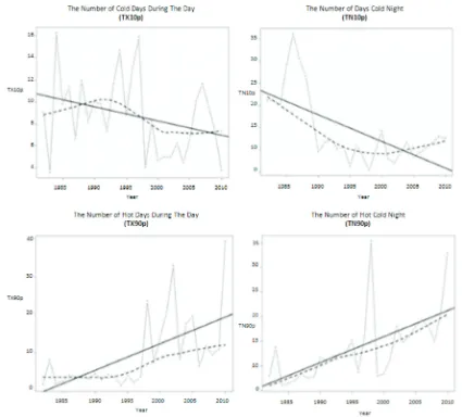
The increasing trend of GHG concentration had a direct effects on the temperature and the extreme rainfall index in Padang. Trend of extreme temperature indices (TX10p) declined followed by incline of TX90p trend. This condition will make high temperature during day and night (Figure 3).
This is one of indicator that Padang already experiencing global warming. According to the IPCC [2001] that global warming is an indication of climate change has been caused by increasing greenhouse gases in the atmosphere.
The Trend of extreme rainfall occurred in Padang was characterized by an increasing of Rx5day compare to Rx1day. It has implication on high rainfall intensity in a relatively short time. The dominant developed area will have an accumulation of surface run off. The high volume of surface-run off will lead to flooding event,
flash flooding and landslides [Hermon, 2009; Hermon, 2012]. The high rainfall intensity in relatively short time will caused the declining CWD trend and inclining CDD trend. These conditions will lead unstable hydrological phase in the region.
4. Conclusion
Land cover changes into developed area land especially in forests, gardens and shrubs lead into the increasing of GHG concentrations. The increasing of GHG concentration will have direct effect on global warming and climate change. It had been marked that higher temperatures during the day and night and trends of extreme rainfall where high rainfall intensity in relatively short time.
IMPACTS OF LAND COVER CHANGE Dedi Hermon
141
BPS Padang (Padang Bureau of Statistics). (1981),
Padang in Figures. BPS Padang, West Sumatera Province.
BPS Padang (Padang Bureau of Statistics). (1995),
Padang in Figures. BPS Padang, West Sumatera Province.
BPS Padang (Padang Bureau of Statistics). (2006),
Padang in Figures. BPS Padang, West Sumatera Province.
Dahroni. (2008), Spatial analysis of change and distribution of slumps in Banjarsari Sub-district Surakarta City 2001-2005 (in bahasa), Forum Geografi 22(1): 85–96.
Departemen Kehutanan and IFCA. (2007), REDDI, Reducing Emissions from Deforestation and Forest Degradation in Indonesia, REDD Methodology and Strategies Summary for Policy Makers, Dephut, Jakarta.
Hairiah, K., & Rahayu, S. (2007), Measurement of carbon stock in various land use in Bogor (in bahasa). World Agroforestry Centre – ICRAF, SEA
Regional Office, University of Brawijaya, Unibraw. Harun, U.R. (1992), Land use resources dynamics in
West Java 1970-1990, Jurnal PWK 3: 48-53. Hermon, D. (2009), Settlement dynamics and land
use planning policies in landslide prone areas in Padang City (in bahasa), P.Hd. Dissertation, IPB, Bogor.
Hermon, D. (2010), Environmental Geography, Global Environmental Change (in bahasa), UNP Press, Padang.
Hermon, D. (2012a), Hydrometeorological disaster mitigation: Flood, landslides, land degradations, ecology, droughts, and local tornadoes (in bahasa),
UNP Press, Padang.
Hermon, D. (2012b), Carbon stock dynamic based on land cover changes towards settelment areas in Padang City (in bahasa), Jurnal Forum Geografi (26)1: 45 - 52.
Ketterings, Q.M., Coe R., van-Noordwijk, M., Ambagau Y., Palm C.A. (2001), Reducing Uncertainty in the Figure 3. Trend of Extreme Rainfall Index in Padang
Indonesian Journal of Geography, Vol. 46 No. 2, December 2014 : 138 - 142
142
of Allometric Biomass Equation for Predicting Aboveground Tree Biomass in Mixed Secondary Forest, Forest Ecology and Management 146: 199-209.
Kustiawan, I. (1997), Agricultural Land conversion issues and implications for spatial planning. case studies; the northern coast of West Java Region (in bahasa), Jurnal PWK 8: 49-60
Lusiana, B., van-Noordwijk, M., Rahayu, S. (2005),
Carbon stock in Nunukan-East Kalimantan; Spatial monitoring and modeling (in bahasa), ICRAF, Bogor Pribadi, D.O., Shiddiq, D., & Ermyanila, M. (2006),
Models of land cover change and it affecting factors (in bahasa), Jurnal Teknologi Lingkungan 7: 35-51. Ritohardoyo, S. (2007), Coastal rural settlements change
in Gunung Kidul, Yogyakarta Special Region in 1996-2003, Forum Geografi 21(1):78 – 92.
WWF. (2008), Deforestation, Forest Degradation, Biodiversity Loss and CO2 Emissions in Riau, Sumatra, Indonesia, One Indonesian Province’s Forest and Peat Soil Carbon Loss over a Quarter Century and its Plan for the Future, WWF Indonesia
Technical Report, Jakarta.
Zain, A.F.M. (2002), Distribution, Structure dan Function of Urban Green Space in Southeast Asian Mega-Cities with Special Reference to Jakarta Metropolitan Region (JABOTABEK),