ISBN
: 978*g7g*g38g*t
E-d
SEMINAR
NASTONAL
DAN
RAPAT
TAHUNAN
N[,I{AN
Biclang
IImu-llrnu
f=ertanian
Badan
Keriasarna
Perguruan
Tingggi
Negeri
(BKS-PTN)
Witay
rh Barar
VOLUTWE
ff
.E.fl,x1&& ;
PERAN
IFTEK
UNTUK MTNCANTT$IFRSi i}r&Us&fu*&i\j
gKl;ffi
trAI.AN4
PERSI}EKTTT
PTRTAN
fuqN
S H,R.KLLAru}ilTAru
FAKUIIRS
PEKTANIAN
,
uNrvERSrrAS
SRrwrlAvn
:
i:. ..
;'",,,
r$ffi,i
c,
23
- zs
MEI
zor
t1s-Fs
,*j
_ -Eb.Prosiding Semirata Bidang rrmu_Imu perranian BKS_rrN
:x1:irffiffi
::,j
trmpact of Land Use Change otr
organic Matter
Content and physical propertiesof
soil
inBukik
Pinang-Pinang under Tropical Rainforest,Mount
iadut
west
snmatra
so'pnYvtf
:ffi illg}ffiTffi:.;#,ffi'#,',lii',",.,,*
*) Email :
ita*lamsoeddin@yahoo. cam
ABSTRACT
(A
stufu
about soil organic matter vflrrytt?n and soil physical properties as affected byland use
change hcd been conducted
in
in
Bukik Pinang-Pinnng,trapial'ratn
for"st""areo.
The area isIocated approximat-ety
?0
kmfrom
padang
"ity
gdb.z9'40,'_Ia0%0,20,,
E
and
0o54,ss,,_0"55'45" s), wtth oltttude 38a-640 m
asl.
rhtsaria
is knownas the wettest
part
in Indonesia, evenin the world' due
to
its high qrnualroinfall yhich
is apto
6s00mm/y.
The waterJlows dawn to Padang
city
through BatangKuranii,
oneof
the biggest rivers passing thecity.
Bukik pinang-Pinang and the surroundings fwrction ashyirotog,,iigaowyni
tlrediwn
"rriron*"nt,
thereforeit
must be well-managed. The obiectiveaf
thereseirch
wasto
determinesoil
organic matter content and physical properties at threedffirent
types of land use in Bukik pinang-pinnng. Soil organic matter content af non-forest land use (mixeineis
and bush tand) tendei to ne higher than forest ecosystem. Fuwhermore, soil texture on theforest and bushkndiasfii,
ilr"n on the mixedperennial
trees.
Bulk
densityand
total porosityof
thesoil
was eategirized
as
medium, and permeability was considered asfastfor
each land usi.)Keywords z Roinforest, land use change, soil organic matter cofttent,
soil physical properties
IITTRODUCTPfl
Land use change has intensively happened lately in developing countries. The changing is
not only limited to urban areas, but also to rural areas,
iven
in remote areas which is considered asconservational
region.
The changing can!9
{om
farming landto
non-ug.i;uiiurul purposes or from virgin ecosystems (forest)toiultivated
land or even oaie land. The lasi is conducted illegallywhich often happens in remote areas, aiming to cut the wood without replantinj it,
,urt
as in Bukik
Pinang-Pinangarea-
_Based on Agus (2005) intensive land use change in Indonesia has been started
since last
few
decades. Therefore,fertile
agricultural land continuously reducedby years.
As reporfed byIrianto
Q}aq
that around 22,0A0 ha ricefield in
Java island was conversed during
1987
-
1993' Even,it
has reached 100,000 haofrice
field that had been conversed by the endof
year 2040.Bukik
Pinang'Pinangis
located approximately30
km
from
padangcity
(100.29,40',-100"30'20"
E
and 0o54'55--0"55'45- S),-on altitude 480-64.0 masl.
Thisarea is known as the wettest part
in
Indonesia, evenin
theworld. It
receives upto
6500 rnm/y6asyiOin,
l9g4).In
climate classification't!it^u.tuj.
grouped jnto '4fo-
Amatyp-" umeo onropp*,--ina
^nA
basedon-oldeman (Ogiono,
_1934). Therefore,
it
is c;lled ur
rupo
wet tropical rainforest.
The water collected on the area flows down to Padang ci,ty through Batang Arau, oneof
the biggest riverspassing the
city.
SinceBukik
Pinang-Pinangis locatel
ontheligher
altitude, the area andthe
surroundings function as hydrology regulatoi
for
the dor,vnward environment, especially padangcity, the capital
of
West Sumatra. Therefore,it
must be well-managedto
avoid natural disaster, such as flood and land slide during rainy season aswell
as drough:t duringof
,**on,
whichthreats our sustainable environment.
Manggis, cinnamon, cacao,
Duh)
and some was abandon and grownby
bush. whether thecondition changed the organic matter content and
the soil physical properties of the soil or not was
interested to
know'
soil
organic matter colfient and physicai property-determination are important as a data basefor
findingout
the best management appliedtr
ttt"
t*0.
rhe
oujective
of
theresearch was to determine soil organic matter content an-f soil physical
pr"e"ni*
at three different land uses in tsukik pinang-pinang.
MATERIALS
AF{DMETHODS
Survey rnethod was employed firr this researclq and the soil was
ran
omly sampledin
eachland use (purposively random sampling) on
0-20
and 20-40 cm depth.Thr;.
tp",
of
land use inthe area were primary fu1"l, Gn the top,
*
635440m
asl,l0o slope, and on the middle, + 570-5g5m asl, 18-22 slope), bush land (+ 590-600
m asl,4-22
siope),ryd
mixed perennial trees (*
390-398m
aslwith
t
8oslope).
satellite soil sampier*"r
dt*_for
soil texture (sieve and pipettemethod),
soil
organic matter(walkley an{
Biack
method), then undisturbedsoil
samples for permeability (constant head rnethod based.on
Darcy's
ra*y, bulk
densi,f
anototat
porosi,ty(gravimetric
urethod).
soil
sarnples were dried and unrtvruo-in soil scienci tauoratooy, AndalasUniversity. Data from the analyses were compared
to criteria of soil characteristics.
REST]LT
A}[D
DISCUSIONA.
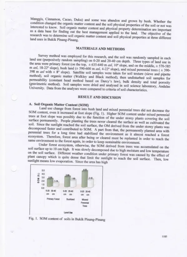
Soil OrganicMatter
Content (SOM)tand
use change frorn forest into bush land and mixed perennialtrees did not decrease the
soM
content, evenit
increased at foot slope (Fig.l).
HighersoM
content under mixed perennial trees at foot slope was possibly due
to
thenrnition or
iire under storey plants covering the soilsurface.permanently.
-Peoplg planting the trees never cleared the surface as
well
as cultivafed thesoil'
since the sunlight reached trre soit surfaceo theoM
derivedfrom the under storey plants was decomposed faster and contributed
to
soM.
A
partrro* tr*t,
trt"p"r**"otry
pi*t"o
area with
perennial kees
for
a
long
time
had stabilizedthe
"*itot**t
as
it
almost reacheda
forestecosystem' Therefore, forest area after being
or
cleared rnust be replanted
i"
ord*
to
reach thssame environment to the forest agarn, in orderto keep sustainable environment.
under forest ecosystem, otherwise, the
soM
derived fromtrees was accumulated on the soil surface up to 10 cm
high.
It was slowly decomposed due to high moisture*oio*
temperature on the soilsurhce.
Different weather condition;d* d;ny
foiest was caused by the effectof
plant canopy
which is
quite dense thatlimit trrr
r*riirii-il'.ea"h
thesoil surface.
Theno lowsunlight rneans low evaporation. Since the area has high 5.0
s
4"0;
3.0o
2,0ea
1.0
0.0
ffiffiffi
Prirnay fmstGru
2040
&20 20-10cm
cIn
cm cmBushland Mixeed parennbl
Trs
os
&40cln cm
Lrnd lJse
[image:3.612.4.603.11.832.2]rainfall
annually,
low
evaporation keepsthe
soil
surfacequiet
humid.
Therefore,as
the consequenceof
the-condition,the
organic-matter decomposers worked
slower. As
found by Yulnafatmawita et al., (2003) that land 'rse change from foiest into pasture for about 100 years in rainforest areain
Queensland Austmlia did not show significant differentof
the SOM content onthe top 0-20 cm depth. In adjacent site to Bukik Pinang-pinun
g,
that is Bukik Gajabuih, theSoM
contentof
the primary forest was lower than that in bush land and mixedp.r"rriiul
tree typesof
land use (Yulnafatm awit4 et al., 20A7).
Furthermore, from Figure 3 also showed that SOM content
of
the soil decreased from thetop 20 cm
depthinto 2a40
cm
depthfor
each landuse. As
soil
organic matter sourc€ wasprimarily from
above ground, the organic matter contentof
thesoil
direased by
lower depthwithin soil
profile.
It
was also
found
to
be true
in
Bukik
Gajabuihfor
eachland
use
(Yulnafatmawit4
et
a1.,2007), the SOM content decrease at deeperroil
luy.r.
Higher amountof
SoM
contentin
soil profile
is
really
expectedto
increase organiccarbtn
sequeshationor
to decrease carbon content(C02
concentration)in
atmosphere. Carbon dioxide was oneof
the greenhouse gas which gives the highest contribution to global warming (AGO, 2002).B.
Soit Physical Properties1.
Particle Soil Distribution and Soil TextureAs shown in Figure 2, soil on the tg,p of higher slope are4 under primary forest ecosystem,
was dominated
by
fine particles(clay).
The lower the aititude tendedio
Oe ttre coarser the soilparticles.
The soil under mixed perennial trees (on foot slope) was dominatedby
silt.
The soil texture on the top forest aswell
as under bush land on the middle slope was classified into clay,while
on thefoot
slope was loam (based on texture triangleby
USDA). ttre
differencein
soil texture among the land use much depends on the parentmaterials.
Based on Wakatsuki et ol. (1986) thesoil
onthis
area wasstill
newly developed (order Incepisols),with
suborderLithic
Dystropept' Lithic EutroPePt, and' Typic Dystropept on thetop.
While on the-foot slope, soil texturewas much affected by the river @atang Lantiak) passing ttrougtr the area.
The area on
tl9
foot slope having coarse soil texture fraO frigh infiltration rate compared tothe other two types
of
land use (Yulnafatmawit4et
al.,2009).Hig[ infiltation
means lowrunofi
and high chance of SoM
gget
into deepel soil p_rofile and sequestered in soil, as a consequen! lowpossibility
of
erosion.
Thenothe function
of
the
areaas
a
regulatorfor
hydrologycan
bemaintained.
The pattem
of
soil particle size distribution on upper soil profile was also foundo n
thelolver
layer.
For primary forest and food land, the particiesof
the soil were dominated by clay.Clay content
for
each land use tended to. increaseby
soildepth.
It
means that migrationof
cUy from upperto
lower partof
soil profiles happenedin
each landuse. ]lhis
wasttiglfv
possible tohappet! since the annual rainfall
of
the areawas veryhigh.
High
SOMcontentlf
the soil and^75
+$.
g.g 50
y4
'S
250
--Fd
I*i Ff,
0-10 cm
E!
iFe
I ].rq
10-2Q
cm
##
s Sand
r
Sih E Clay0-10
10-cm
20 cm0-10
10-cm
?0 cm Frimary Forest Bu$ Land MixedLand tlse
Fig.2. Particle size distribution
of
soils in Bukik Pinang-Pinang2.
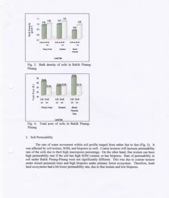
Bulk Density and Total PoreSoil
bulk
density and total pore as shownin
Fig.
3 and4
were not significantly different among the types of the land use. This was due to the texture and the OM content of thesoil.
Soil having fine texturewill
have low bulk density (BD) and high total pore, while coarse texturewill
be the viceversa.
Then, soilwith
high SOMwill
have lowBD
and high totalpore.
Therefore,even though soil under mixed perennial trees had coarser texture, the values of the bulk density and
the total pore were not significantly different from the other land useo because
it
had higher SOM content compared to primary forest and bush land.Fine textured soil on the primary forest combined with much roots in soil profile had lower
soil
bulk
density than bush landuse.
The difference could be dueto
the contributionof
rootsowhich was higher densrty in soil under forest than that under bush land. Therefore, even though the
class textured was the same, the bulk density was different.
At
mixed perennial trees, on the other hand, the value of the BD was lowerthan those at other land use, even though it had coarser soil texture. Lower BD of the soil under mixed perennial treeswas due
to
its high
SOMcontent.
Soil
organic matter content can reducesoil
mass per unit volume. Therefore, soil organic matter can modifr textural characteristics of the soils. As reportedby Yulnafatmawita et al (2009) that SOM content did not only decrease soil
BD,
increased totalsoil
poregbut
it
also improved stabilityof
aggregates. There was positive linear correlation between SOM content and soil aggregate stability {Yulnafatmawita,2006). Stable soil aggregatesis really important
to
create to avoid aggregate dispersion or degradation as soilis
introduced to water.The value
of
soilBD
is negatively correlatedto
percentageof
total
soilpores.
It
can beo^
'E 6s
5Ct :t ta
SEmlS40 S2gso20.{0 0{0{*D2SS
€R rm €sl
gtFryM,&Fbhnd,l&€€d kw*i
tardlhe
il$m
ffi
0.7,
Fig.
3.
Bulk
&nsi,tyof
soitsin
Bukik
PinangPinang
Fig.
4.
Tatal
poreof
soilsin
Bukik Finanp
Pinang3.
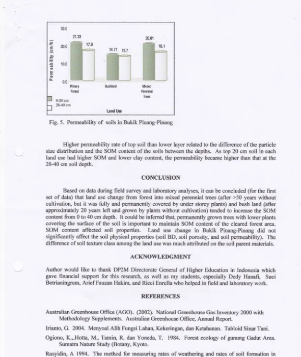
Soil FerrneabilityThe rate of water movement
within
soil profile rtnged &om ratlrsr fastto
fast$ig.
5). ft
was affeeted by soil texture, SOM, and biopores aswell.
Coarse textweswitl
irtc,rrease perrneabilityrate of the soils due to their high macropores percentage.
&r
the otlrcr hand, fme texture can havehigh penneabilfy rate
if
the soil has high SOM cont€nt, or has biopores- Rateof
pemreabilrty in soil under Bukik Pinang-Pinang were not significantlvdifferent.
This was due to corltrs€rt€xtu€
under mixed perennial fiees and high biopores under prirnary forest ecorysfierr" Therefore, bush
land ecorysterns had a bit lower permeability rate, due to frne tesure and low biryores.
s
^66
€6a
4
f,6?
Em
€F
ffi
S20
&.S,
,$ff]S.S
{}fl} Ad}cln
cm
cmtn
{m . ctnPrirrry
Forest
esHard tfixedPeernid
Tm
[image:6.612.12.604.18.713.2]20.81
ffiJl
ffil
ffi
tffi_J
;teed
ftremid
Trees
14.71 8.7
ffi
ffif
ffiI
ffit
w__j
&$hlald 21.73
ffig\
ffii
ffi_j
R*$ry ftil?S
30.0
E
20.0 a,>
=
E
$.0o
E
o
s
o.oGZOcrn 2&4Ocm
tend ttse
Fig.
5.
Permeabilifyof
soils in Bukik Pinang-PinangHigher permeability rate of top soil than lower layer related to *re difference of,the particle size dishibution and the SOM content of the soils between the depths. As top 20 cm soil in each
land use had higher SOM and lower clay content, the permeabiliq'became higher than that
d
the 20-40 crn soil depth.CONCLUSION
Based on data during field survey and laboratory analyses, it can be concluded
(forthe
firstset
of
dat*) that land use change frorn fiorest into mixed pererurial trees (after >50 years withoutcultivatioq
butit
wasfully
and permanently covered by under storey plants) and bush land (after approxirnately 20 years left and grcwn by plants without cultivation) terded to increase the SOM cont€nt frorn 0to40
cm depth. It could be inferredtha!
perrnanently grown trees with lower plants covering the surface of thesoil is
important to maintain SOM contentof
the cleared forest area.SOM
content affectedsoil
properties.
[,and use
changein
Bukik
Pinang-Pinangdid
not significantly affect the soil physical properties (soil BD, soil porosi,ty, and soil permeability). The difference of soil texture class among the land use was much attrib,uted on the soil parent materials.ACKNOWLEDGMENT
Author would
like
to thank DP2M Directorate Generalof
Higher Educationin
Indonesia which gave financial supportfor this
researcho aswell
asmy
students, especially DedyHanafi,
Suci Betrianingrum, Arief Fauzan Hakim, and Ricci Enrella who helped in field and laboratory work.REFERENCES
Australian Greenhouse Otfice
(ACO).
{2OOZ). National GrenhouseGas Inventory 2000with
Methodolory Supplements. Australian GreEnhouse
Office
Anmml Report.Irianto,
G. 20M.
Menyoal AIih Fungsi Lahan, Kekeringan, dan Ketahanan. Tabloid $inm Tani. Ogiono, K.,.I{otta, M., Tarnin,R
dan YonedaT.
1984. Forest ecologyof
gunung Gadut Area.SumatraNafire Shdy (Botany, Kyofio.
[image:7.612.10.601.26.727.2]Wakatsuki, T", Saidi" A. and Rasyidin,
A.
1986. SoiIiil
topsquenceofthe
gunung Gadut tropicalrainf,mst
West Stnnatra.
Sauth EastAsim
Swdie s 24 (3) : 24 i -2 62Yulnafa&rra\ilrtq $o, H.ts., Dalal, R-C. and Menzies,
N"W.
20CI3a COs ernission frorn diff,erentsoil
fractiort following physical disruption: Irnplication for tillage practices. Proreeding on thelfh
TriermiclInt'l
SailTillage
Res.Org.(ISTRO)Co{ercna
13-18 July 2CI03, BrisbaneAustralia
Yulnaftfinawita.
2006.
Hubungan antara statusC+rganik
dan stabilitas aggegat tanah Ultisol Lirnau Manis Padangakibat
penggunaanlahan.
Proceeding Seminar Tahunan BKS 25-28April
2006, JarnbiYulnafatnawit4 Luki, U., dan Yanq
A.
?W7.
Kajian Sifat Fisika Tanah Beberapa Fenggunaan Latran di Bukit Gajabuih Kawasan lfutan Hdan Tropik Gunung Gadut Padang. J. SolumVol.
IV
No-2 Juli 2A07:8-]9
Yulnafufirawit4 Asmar, dan Enrella,E.
2m9.
Peng$kurarr trnfithasi Tanah B,ukit Pinang-Pinang Kawasan Hutan Hujan Tropik Gunung Gadut Padang Di Laboratorium..{
Solum YoL W No.