ROAD MARKING EXTRACTION USING A MODEL&DATA-DRIVEN RJ-MCMC
A. Hervieu, B. Soheilian, M. Br´edif
Universit´e Paris-Est, IGN, SRIG, MATIS, 73 avenue de Paris, 94160 Saint Mand´e, France (alexandre.hervieu, bahman.soheilian, mathieu.bredif)@ign.fr
KEY WORDS:RJ-MCMC, Prior-driven, Data-driven, Road marking, Image
ABSTRACT:
We propose an integrated bottom-up/top-down approach to road-marking extraction from image space. It is based on energy minimiza-tion using marked point processes. A generic road marking object model enable us to define universal energy funcminimiza-tions that handle various types of road-marking objects (dashed-lines, arrows, characters, etc.). A RJ-MCMC sampler coupled with a simulated anneal-ing is applied to find the configuration correspondanneal-ing to the minimum of the proposed energy. We used input data measurements to guide the sampler process (data driven RJ-MCMC). The approach is enhanced with a model-driven kernel using preprocessed auto-correlation and inter-auto-correlation of road-marking templates, in order to resolve type and transformation ambiguities. The method is generic and can be applied to detect road-markings in any orthogonal view produced from optical sensors or laser scanners from aerial or terrestrial platforms. We show the results an ortho-image computed from ground-based laser scanning.
1. INTRODUCTION
Road markings are painted on the road surface to provide traf-fic rules to drivers and pedestrians. Since the 90s, Inteligent Trasportation Systems (ITS) applied on-board lane marking de-tection to drive within a portion of the road (Bertozzi and Broggi, 1998). In the last decade the dedicated methods became more and more elaborated and some benchmarks were proposed (Veit et al., 2008; Fritsch et al., 2013). Most of the methods developed by the ITS community are devoted to 2D road-marking detection in image space. Nowadays, there is a growing need for georef-erenced road-marking geographic databases. Such databases are required in applications such as road modelling for traffic sim-ulation (Despine and Baillard, 2011) and precise absolute local-ization of vehicles (Ziegler et al., 2014). In this paper we aim at developing a generic approach for extraction of road-marking from an extensible road-marking library.
1.1 State of the art
Road-marking mapping was investigated by photogrammetric com-munity using ground-based stereo-pairs acquired by MMSs (Mo-bile Mapping Systems) since the 90s. The proposed methods in (He and Novak, 1992; Tao et al., 1998; Habib, 2000) stud-ied detection and 3D reconstruction of center-lines. Soheilian et al. (2010) presented an approach for 3D reconstruction of zebra-crossings and different types of dashed-lines.
Some other systems used high resolution georeferenced aerial im-ages (Steger et al., 1997; Tournaire et al., 2006; Kim et al., 2006).
Since development of ground-based mobile Laser scanners, some authors used intensity of 3D point clouds for road-marking seg-mentation. Most of the authors compute a road ortho-image us-ing intensity of points. Segmentation step is then performed in the image space by chaining a set of thresholding and morpho-logical filters (Yang et al., 2012; Kumar et al., 2014; Guan et al., 2014). Yu et al. (2014a) used the same strategy of segmentation followed by clustering the pixels into individual markings that are classified to semantic markings.
Most of the aforementioned methods are based on bottom-up strategy. They begin with low level feature extraction. Then
grouping algorithms provide higher level objects that are classi-fied in semantic categories by classification algorithms. Bottom-up pipelines are fast and geometrically precise but very sensible to imperfections of input data.
In contrast to bottom-up approaches, top-down methods take ben-efit from the known context (prior) to propose plausible solutions and verify their coherence with image data. Generally, top-down approaches are more robust to imperfections in the input data, but in return they are slower. This strategy was also applied to the problem of road feature extraction. Lacoste et al. (2005) detects road network with stochastic point processes in remote sensing images. Similar methodology was applied by Tournaire and Pa-paroditis (2009) for rectangular road-marking and by Yu et al. (2014b) for manhole detection.
To conclude, many authors investigated bottom-up or top-down approaches to road-marking detection. Some of them deal with road-marking type recognition with a set of ad-hoc methods adapted to different road-marking types. We aim at developing an inte-grated bottom-up/top-down approach which deals with any type of road-marking.
1.2 Proposed approach
We propose a top-down approach, based on a Marked Point Pro-cess of roadmarking instances. It combines the advantages of a top-down approach which enforces global priors (eg : object interactions) and the increased performance of a data-driven ex-ploration of the search space. A fist contribution is the proposed modelling of the roadmarkings from an extensible library of bi-nary templates. Secondly, this approach is supplemented by a model-driven kernel, which uses a preprocessing of the road-marking templates to resolve type and transformation ambigui-ties. Namely, a roadmarking template is correlated with all pos-sible type and transformation modifications in a generic prepro-cessing phase which is data-independent. This analysis is used to escape from local minima by proposing roadmarking configura-tion modificaconfigura-tions that tend to explore neighboring local minima.
Jump Markov Chain Monte Carlo (RJ-MCMC) approach. Fi-nally, sections 4. will analysis the results, before concluding in section 5..
2. PROBLEM FORMULATION 2.1 Input data and pattern library
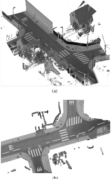
In this study we use georeferenced point clouds acquired by a MMS in urban areas (cf. Fig. 1(a)). An ortho-image is computed by vertical projection of points. The pixel size is set according to the resolution of points. To every pixel is associated the intensity value of the lowest projected point. A set of morphological fil-ters is subsequently applied to fill in the holes, following similar approaches to (Yang et al., 2012; Kumar et al., 2014; Guan et al., 2014). Fig. 1(b) shows the ortho-imageIcorresponding to our running example.
In most countries, road-markings are painted following strict ge-ometric specifications. We propose to use such a specification as a pattern libraryLof road-markings. This specification is for in-stance available in France as theInstruction interminist´erielle sur la signalisation routi`ere1(Fig. 2).
(a)
(b)
Figure 1. (a) 3D point cloud, (b) corresponding ortho-imageI (GSD= 2cm) generated from points’ intensities.
2.2 Model definition
Road-marking detection is formulated as positioning an unknown number (n) of patterns (Iℓi∈ L) in imageI. Positioning consists here in determining conformal parameters (x, y, θ, λ) allowing
1
Instruction interminist´erielle sur la signalisation routi`ere. Septi`eme partie: Marques sur chauss´ee. Minist`ere de l’ ´Ecologie, de l’ ´Energie, du D´eveloppement durable et de l’Amenagement du territoire. Dec. 2011. Paris, France
Figure 2. A sample of our road-marking pattern libraryLwith
(GSD = 2cm). The white (resp. black) pixels correspond to the road-marking object (resp. background) and the grey pixels indicate mask pixels inside which the correlation (data term) is computed.
to re-sample a pattern to image space (cf. Fig. 3). The whole configuration of roadmarkings is parameterized by a vectorX:
X = {Xi}i=1...n (1)
where :
Xi = (ℓi, xi, yi, θi, λi)roadmarking parameters (2)
n : number of objects∈N
ℓi : pattern label∈ {1. . .kLk}
xi, yi : position∈[0, xmax]×[0, ymax]
θi : rotation∈[−π, π]
λi : scale∈[1−ǫ,1 +ǫ]
We further denoteTx,y,θ,λthe change of coordinates that maps
the pixels of the road-marking patternIℓ to its reconstruction
Irec(Xi) =Txi,yi,θi,λi(Iℓi)onto ortho-imageI.
x
y
θ
Ibike
Tx,y,θ,λ
Tx,y,θ,λ(Ibike)
Figure 3. The objectiwith parameters (ℓi=bike,xi, yi, θi, λi).
2.3 Energy formulation
We apply an energetic formulation to the problem. The energy should reflect the coherency of the road-marking objects, param-eterized byX, with the ortho-imageIand prior knowledge con-cerning the objects. We define an energy function that is com-posed of two terms called external (data attachment) and internal (prior) as follows:
U(X) = Uext(X) +Uint(X) (3)
In the following sections we explain these energies.
2.3.1 External energy term External energy called also data attachment expresses the likelihood of the objectsX in relation to the imageI. We have :
Uext(X) = n
X
i=1
We define functionfthat measures the coherency of an objectXi
with imageIusing zero-mean normalized correlation (ZMNC):
f((ℓ, x, y, θ, λ), I) =ZM N C(Iℓ, T−
1
x,y,θ,λ(I))∈[−1,1] (5)
Iℓis the image template of patternℓin the road-marking library
L(Fig. 2).T−1
x,y,θ,λis used as it is the input ortho-imageIwhich
is re-sampled to the pattern geometry. In order to reduce the effect of neighboring road-markings (where the bounding box of two road-marking objects have an intersection for instance) the ZMNC is computed using only the pixels situated in a mask around the pattern (grey regions in Fig. 2). We used ZMNC be-cause it is the simplest measure of similarity that is quite invariant to changes in local contrasts. This measure can be substituted by more robust measurements such as mutual information (Maes et al., 1997) without any change in the algorithm.
As shown in Fig. 4, the external energy associated with the object Xiis computed using the following equation:
uext(Xi) =f
0
−max(0, f(Xi, I)) (6)
In this equationf0
∈(0,1)is a similarity threshold below which the external energy will be positive and penalize the object. This parameter was set manually by trial and test tof0= 0.35. Thus, if the similarity score is higher thanf0
, the associated energy is negative and leads to reduction of total energy. Lower scores increase the energy.
f
(
X
i, I
)
u
ext(
X
i)
−
1
1
f
0
Figure 4. External energy value as a function of ZMNC
2.3.2 Internal energy term The internal term introduces prior knowledge about the road-marking objects into the energy. It is computed based on the interactions between pairs of objects. In this work only overlap interaction was applied:
Uint(X) =
X
i<j
uoverlap(Xi, Xj) (7)
Overlap interaction This energy enables us to penalize the overlapping objects. It is computed for pairs of nearby objects. First the overlap of bounding boxes are tested. In case bound-ing boxes overlaps, a pixel-wise overlappbound-ing test, measurbound-ing the proportion of the overlap, is performed (cf. Fig 5).
The overlapping energy is defined as follows:
uoverlap(Xi, Xj) = β
|S(Xi)∩S(Xj)|
min(|S(Xi)|,|S(Xj)|)
(8)
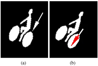
(a) (b)
Figure 5. An example of pair-wise overlap. (a) Non-overlapping objects. (b) Overlapping objects with overlap region in reds.
whereS(ℓ, x, y, θ, λ) =Tx,y,θ,λ(Iℓ)is the resampled image of
the pattern and| · |and∩denote respectively the area and inter-section of white pixels. The coefficientβexpresses the influence of overlapping energy in the total energy. This energy is a penal-izing energy and is equal to0for non-overlapping objects.
3. OPTIMIZATION
3.1 Marked point processes, RJ-MCMC and Simulated an-nealing
The optimization problem at hand is facing a search space with varying dimensionality, as the number of road-markings itself is to be determined. Similar to (Tournaire and Paparoditis, 2009), we adopt a global strategy that is based on stochastic geometry, namely Marked Point Processes. Each road-marking object may indeed be defined as a point(x, y)with continuous marks(θ, λ)
and a discrete markl. Thanks to the homogeneous parameteriza-tion of objects across road-marking types, there is no need to con-sider a Multi-Marked Point Process (Lafarge et al., 2010; Mallet et al., 2010), simplifying the approach.
The solution of the optimization problem is sought as a realiza-tion of a Marked Point Process. Thus the search space must be probabilized using a so-called reference process, which is gen-erally taken as a Poisson distribution over the number of objects coupled with an independent sampling of each object parame-ters uniformly over the search space. We propose here a data-dependent reference process that replaces this uniform object pa-rameter distribution with a distribution biased by a likelyhood map computed from the input dataI. This distribution will be presented in section 3.2.1. This has the advantage of not even proposing roadmarkings that fall in the image but not on the road where lidar points have been acquired.
Reversible Jump Markov Chain Monte Carlo (RJ-MCMC) en-ables the sampling of a Marked Point Process that is sampled from an unnormalized target distribution. By embedding the RJ-MCMC sampler inside a simulated annealing framework, Monte Carlo sampling is turned into an optimization procedure : the tar-get distribution evolves continuously from the reference process at temperaturet=∞to a discrete sampler of the global energy minima att= 0, provided that the temperature decrease is suf-ficiently slow (logarithmic). In practice, the initial temperature is commnly chosen sufficiently high and a geometric temperature schedule is preferred for faster processing at the cost of loosing the global optimality property (Descombes, 2012).
Green ratio ensures that whatever which kernel is used, the result-ing Markov Chain of configurations converges to the desired tar-get distribution, as long as the whole support of the tartar-get distri-bution is reachable by composing kernel modifications. This en-ables the modular use of kernels which come in pairs to propose reversible configuration modification (jumps). Whereas Birth and Death kernels are sufficient for the algorithm to be correct, the following kernels enable a smarter exploration of the search space by tunneling between parameter subspaces that yield similar en-ergy levels, aiming at the connecting regions containing distinct function minima.
3.2 Data-driven Birth and death kernels
Birth and death kernels allow to add an object to the configura-tion or remove it. These kernels correspond to jumps in higher or lower dimensions and ensure to explore the whole configura-tion space. These kernels allow to resolve for unknown number of objects in marked point processes. In most of the RJ-MCMC samplers, points and marks are sampled from uniform distribu-tions supposing that no information about the distribution of pa-rameters is available. Similar to (Zhu et al., 2000) we propose to apply bottom-up pattern recognition techniques in order to guide the top-down approach. This is done by estimating a coarse pre-diction for the point distribution of the marked point process. Thus, in the birth kernel the points are sampled from the esti-mated distribution allowing to visit more frequently the locations predicted as potential road-markings by the bottom-up method. This is done by a set of rough filtering on the input image (cf. Fig. 1(b)).
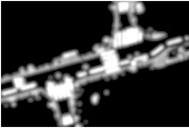
3.2.1 Estimating the road-marking probability density As road-markings generally exhibit much higher reflectance proper-ties than their surroundings, we are looking for bright pixels on a dark background in the input image. In order to amplify the con-trast and to deal with local variations of intensity a top-hat filter is applied on the image. A sufficiently small threshold enables to re-move a large number of background pixels without removing any bright pixel. Finally a smoothing filter provide an image corre-sponding to the road-marking probability density (pdfx,y) shown
in Fig. 6. As one can see, the values of pixels on road-markings are usually higher than other objects (ex. curbs). The background usually yields very small values. This probability map being used in the reference process effectively restricts the search space to its support.
In the birth kernel the points are sampled from the estimated prob-ability density and the marks are sampled from uniform densities.
xi, yi∼pdfx,y (9)
ℓi∼U({1. . .|L|}) (10)
θi∼U(−π, π) (11)
λi∼U(1−ǫ,1 +ǫ) (12)
Even though the ortho-image’s pixel size is known,λiis allowed
to vary slightly around1since in practice the road marking ob-jects are not set-up exactly according to the specifications and the objects can be painted on the road slightly larger or smaller than their specified size.
3.3 Geometric perturbation kernel
This kernel modifies one of the transformation parameters (xi, yi,
θi, λi) of an object (Xi). An object is selected and a parameter is
modified following a uniform distribution. This kernel is useful for adjusting the objects.
Figure 6. An estimation of road-marking probability density (pdfx,y) for the running example of Fig. 1(b).
∆x
(a)
∆θ
(b)
λ0
λ1
∆λ
(c)
Figure 7. Examples of geometric transformations.
3.4 Model-driven perturbation kernel
Perturbation kernels such that the one described in the previous subsection are usually used to modify the position and the geo-metric form of objects, and applied perturbations are most of the time sampled following uniform distributions. In the following, we present a perturbation kernel that can modify all dimensions of an object including type of the mark (ex. Bike→BUS). Also, as it is described in the following section, we aim at conducting the proposed perturbation by estimating their distributions a pri-ori.
3.4.1 Estimating probability distribution of five dimensional perturbation In this section, we describe a generic way to de-termine automatically type and transformation perturbations that may be applied to an object, given a generic collection of road-marking templates, to yield a new object that yields a similar re-constructed image. To obtain a prior distribution on the pertur-bation to apply, we compute ZMNC maps between objects, con-sidering both intra-type and inter-type correlations. In details, we consider a basic objectsi(the original pattern) and compute its correlation with a modified objectjaroundi. Let us consider one of the untransformed original pattern of the road-marking library Xi= (ℓi,0,0,0,1) and another object Xj = (ℓj,xj, yj, θj, λj).
The correlation between the reconstructed imagesIrec(Xi)and
Irec(Xj)is computed and stored in a correlation mapMi. This
correlation map contains such correlations for anyℓj ∈ {1. . .|L|}
and for relative transformation parameters (xj, yj, θj, λj)
dis-cretized as follows:
(xj, yj)∈[−∆x, δx,∆x]×[−∆y, δy,∆y] (13)
θi∈[−π, δθ, π] (14)
λi∈[1−∆λ, δλ,1 + ∆λ]. (15)
Here[v1, δ, v2]is the set containing the valuesv = v1 +k.δ
wherek≥0andv < v2. For any original patternℓiof the
∆x
Figure 8. Two interesting examples showing how the correlation maps control the model-driven perturbation kernel (cf. the text for explanations).
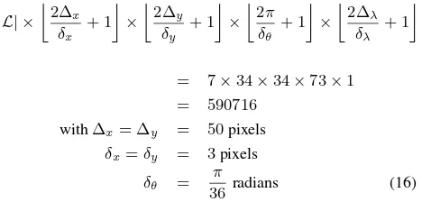
correlation mapMiis :
|L| ×
In order to reduce the noise and thus the number of local max-ima, the patterns were blurred before correlation. The parameters (∆x,∆y, δx , δy, δθ) were empirically tuned in a way to avoid
over-sampling regarding to the significance of correlation scores.
While varyingλjcould yield better results, we only considered
fixed scaling perturbations in our experiments (∆λ= 0). These
correlation maps are turned into probability maps by thresholding negative values and normalization. The perturbations that are the most likely to occur are then sampled using the correlation maps {Mi}i=1,...,n. This is described in figure 8 that presents two
in-teresting correlation results. On the left of the figure, we present a part of the correlation maps associated to theBIG ARROWmark (ℓ= 4). This is the 2D correlation map, whereθj = 0,λj= 1,
ℓi=BIG ARROWandℓj=TRIANGLE. The colors of the
correla-tion map goes from blue (lower correlacorrela-tion values) to red (strong correlation values). Hence, as it is depicted in this part of the fig-ure, applying ay∗
j shift in theydimension to aTRIANGLEleads
to a strong correlation with the originalBIG ARROW(the basic big arrow in the road-marking library). Hence, if aBIG ARROW
mark object Xk = (4, xk, yk, θk, λk) is selected by the
pro-cess, the model-driven perturbation kernel will be likely propose its modification to a TRIANGLE (ℓ = 3) mark object close to Xm= (3, xk, yk+yj∗, θk, λk).
The right part of the figure describes the intra-object correlation map between two objectsXi, Xjof typeBIKE, wherexi=xj=
0,yi=θi= 0andλi=λj= 1. It highlights the fact that
apply-ing a transformation such thatyj=y∗jandθj=θ∗j=πleads to
a strong correlation (the wheels are superimposed). Therefore, a
BIKElooks similar to ay∗
j-shiftedπ-rotatedBIKE, and the
model-driven perturbation kernel will encourage such data changes to be tested. Please not that the discovery of these correlations is done exhaustively on all pairs of type rather than resulting from ad-hoc expert rules.
Hence, model-driven perturbation kernel is sampled following a priori computed correlation distributions that depicts the
sim-ilarities between objects of identical or different type. So, the model-driven perturbation guides the process to look for objects that look similar to the ones already chosen.
4. RESULTS
We present some results of the model and data-driven RJMCMC algorithm with the ortho-image extracted from a point cloud ac-quired by a MMS (see Fig. 1). Such an image is interesting since it contains an important number of marks (39) among several types of marks (4). The proposed method has been implemented using thelibrjmcmcopen-source library (Br´edif and Tournaire, 2012).
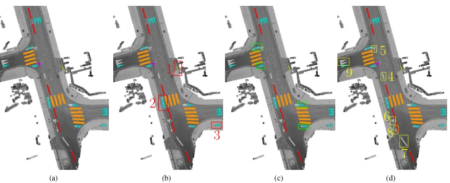
Figure 9(a) presents the final result obtained after more than nine millions of iterations. Such a result is quite satisfying since the algorithm correctly detects 27 of the 39 marks in the image. To obtain such results, a simulated annealing with 9 millions of iter-ations have been computed, with a geometric decreasing rate of 0.999999 and an initial temperature of 10. The process is made offline and may be used for roadmarking database production. With such parameters, it take 8 hours of computation (each of the 10 millions of iterations is composed of several resampling oper-ations). Parametersf0andβhave been set to0.35and100(a highβvalue will prevent from overlapping marks).
False detections As depicted in Fig. 9(b) among the 35 de-tected marks, 2 dede-tected objects do not correspond to roadmark-ings (n◦1and3in Fig. 9(b)) and two triangles were detected on a roadmarking that the method should have been able to detect as a crosswalk strip (n◦2in Fig. 9(b)).
Wrong identifications 4 crosswalk strips are wrongly detected as triangles (Fig. 9(c)). Those strips are situated in the sides of crosswalks where the strips are broken to follow the road curbs. These broken strips can not be modelled by our road marking parametrization. Indeed, the method deals with mark scale varia-tions but is not designed to deal with anisotropic scaling. It would be interesting to deal with anisotropic scaling, to take into ac-count the independent changes of length and width, at the cost of adding 1 dimension to the object’s parameter set. However, detecting such parts of walking area marks as triangles is quite acceptable since the shapes look similar. As an extension, the lack of plausibility of such configurations could be embedded in the prior energy, to penalize these configurations.
(a)
1
2
3
(b) (c)
4
5
6
7
8
9
(d)
Figure 9. Final result of the Model&data-driven RJMCMC algorithm (cf. section 4. for explanations).
Also, we have noticed thatBIKEmarks (objectsn◦5and6) are more difficult to handle than others. Indeed, theBIKEmark is a complex shape compared to other marks with inside holes. Hence, slight changes in the position of the object cause important loss in the correlation score. To detect such marks, the stochastic pro-cess must fall very close to the real one in the image. A possible solution is to enforce the data-driven birth kernel by establishing a more accurate probability density (pdfx,y). This can be reached
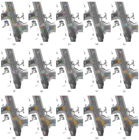
by computing correlation maps betweenBIKEpattern and the in-put image for different orientations and scales providing the prob-ability density of the center of theBIKEpattern on each pixel. Objectn◦7corresponding to a dashed-line was not detected by the algorithm since it is painted on the road as a curve instead of standard rectangular shape specified in the pattern library. The cause of the underdetection of objectsn◦8(an arrow) and n◦9(two triangles) is less clear. A possibility would be the ef-fect of the overlap interaction term which limits the exploration of candidates near already detected roadmarks. More local model and data-driven kernel proposals should improve this situation. Evolutions of temperature, energy and number of objects are shown in Figure 10. Figure 10(b) shows that the method tends to con-verge. After a first step of important variations (during 2 millions of iterations), the energy evolution stagnates (the flat part between 2 and 5 millions of iterations). Finally, the energy tends to its fi-nal minimum in the last part of the process, when it detects marks that fit well on the image.
Figure 11 shows the evolution of the process every 600000 itera-tions. In the beginning, the algorithm explores various solutions in the image (Fig. 11(a)(b)), and then concentrates on the parts of the image where the road-marking probability density is higher. It shows that using such a density map accelerates the process since it quickly focuses on interesting parts of the image. The flat part in figure 10(b) corresponds to images 11(c) to (h), and the last decreasing energy part goes from (i) to (n). The birth/death ker-nel tend to propose large (positive or negative) energy variations. At the last stage, energy increase is almost prohibited by the RJ-MCMC acceptance ratio and good object proposals have already been accepted, yielding an overall poor birth./death acceptation rate. In contrast, most of the small perturbations proposed by perturbation kernels allowing to fit the objects were accepted.
5. CONCLUSIONS AND TRENDS
We have presented in this paper an optimization algorithm based on stochastic geometry to detect punctual road-marking objects
in ortho-view images. A generic model enables us to define any kind of punctual road-marking object homogeneously with one template binary image and four parameters of a conformal trans-formation. Thanks to homogeneous parametrization, the configu-rations of road-marking objects can be modelled by marked point processes and it is needles to use multi-marked point processes. Another interest is in enabling the method to deal with an extensi-ble pattern library for detecting still more punctual road-marking objects. An external (data attachment) together with an internal (regularization) energy functions enable to associate an energy to every configuration. The problem of road-marking detection was formulated as an energy minimization. An RJ-MCMC sam-pler coupled with a simulated annealing was applied to find the optimum configuration. We applied a data-driven birth kernel in order to improve the control of the RJ-MCMC sampler. An-other important contribution of the paper is in proposing a model-driven perturbation kernel improving the efficiency of the process in resolution of type and transformation ambiguities.
This work is in progress and some topics will be investigated in future work. Firstly, we aim at integrating higher level semantical priors in the internal energy such as local pairwise orientation re-lations, and more rules related to road grammar. Secondly, data-driven kernel can still be improved using national road graphs for better control of orientation sampling. Finally, better man-agement of the parameters related to simulated annealing (White, 1984) and associated weights to energy terms (Chatelain et al., 2009) allows to find a trade-off between quality of results and computation time.
In the proposed method, model-driven perturbation is performed using correlation between two vector templates and the data en-ergy uses a vector template as well. Instead of relying on vector templates, roadmarkings could be learned by example from a suf-ficiently representative bank of annotated real datasets to better match the variability of real-world roadmarkings.
Finally, this approach has currently only be applied to datasets of limited sizes. To scale this approach, an interesting data-driven approach we would like to extend is proposed by Verdi´e and La-farge (2012) which parallelizes the RJ-MCMC proposals and ac-ceptations over a quad-tree decomposition of the search space of object centers.
6. ACKNOWLEDGEMENTS
0 2 4 6 8 10
0 1000 2000 3000 4000 5000 6000 7000 8000 9000
(a) Temperature
0 50 100 150 200 250 300 350 400 450
0 1000 2000 3000 4000 5000 6000 7000 8000 9000
(b) Energy
0 10 20 30 40 50
0 1000 2000 3000 4000 5000 6000 7000 8000 9000
(c) Number of objects
Figure 10. Evolution of the temperature, the energy and the number of objects. Numbers on the abscissas correspond to103
iterations.
(a) (b) (c) (d) (e)
(f) (g) (h) (i) (j)
(k) (l) (m) (n) (o)
References
Bertozzi, M. and Broggi, A., 1998. Gold: a parallel real-time stereo vision system for generic obstacle and lane detection. IEEE Transactions on Image Processing 7(1), pp. 62–81.
Br´edif, M. and Tournaire, O., 2012. Librjmcmc: an open-source generic c++ library for stochastic optimization. International Archives of the Photogrammetry, Remote Sensing and Spatial Information Sciences XXXIX(B3), pp. 259–264.
Chatelain, F., Descombes, X. and Zerubia, J., 2009. Parame-ter estimation for marked point processes. application to ob-ject extraction from remote sensing images. In: D. Cremers, Y. Boykov, A. Blake and F. Schmidt (eds), Energy Minimiza-tion Methods in Computer Vision and Pattern RecogniMinimiza-tion, LNCS, Vol. 5681, Springer Berlin Heidelberg, pp. 221–234.
Descombes, X., 2012. Stochastic geometry for image analysis. Wiley-ISTE.
Despine, G. and Baillard, C., 2011. Realistic road modelling for driving simulators using gis data. In: A. Ruas (ed.), Advances in Cartography and GIScience. Volume 2, Lecture Notes in Geoinformation and Cartography, pp. 431–448.
Fritsch, J., Kuhnl, T. and Geiger, A., 2013. A new performance measure and evaluation benchmark for road detection algo-rithms. In: ITSC proceedings, 2013 IEEE, pp. 1693–1700.
Green, P. J., 1995. Reversible jump markov chain monte carlo computation and bayesian model determination. Biometrika 57, pp. 97–109.
Guan, H., Li, J., Yu, Y., Wang, C., Chapman, M. and Yang, B., 2014. Using mobile laser scanning data for automated extrac-tion of road markings. ISPRS Journal of Photogrammetry and Remote Sensing 87(0), pp. 93 – 107.
Habib, A. F., 2000. Matching Road Edges in Stereo-Image Se-quences Using Data Association Techniques. Photogrammet-ric Engineering & Remote Sensing 66(1), pp. 91–98.
He, G. and Novak, K., 1992. Automatic analysis of highway features from digital stereo-images. International Archives of Photogrammetry and Remote Sensing XXIX(B3), pp. 119– 124.
Kim, J. G., Han, D. Y., Yu, K. Y., Kim, Y. I. and Rhee, S. M., 2006. Efficient extraction of road information for car naviga-tion applicanaviga-tions using road pavement markings obtained from aerial images. Canadian Journal of Civil Engineering 33(10), pp. 1320–1331.
Kumar, P., McElhinney, C. P., Lewis, P. and McCarthy, T., 2014. Automated road markings extraction from mobile laser scan-ning data. International Journal of Applied Earth Observation and Geoinformation 32(0), pp. 125 – 137.
Lacoste, C., Descombes, X. and Zerubia, J., 2005. Point pro-cesses for unsupervised line network extraction in remote sens-ing. IEEE TPAMI 27(10), pp. 1568–1579.
Lafarge, F., Gimel’farb, G. and Descombes, X., 2010. Geomet-ric feature extraction by a multimarked point process. IEEE TPAMI 32(9), pp. 1597–1609.
Maes, F., Collignon, A., Vandermeulen, D., Marchal, G. and Suetens, P., 1997. Multimodality image registration by maxi-mization of mutual information. IEEE Transactions on Medi-cal Imaging 16(2), pp. 187–198.
Mallet, C., Lafarge, F., Roux, M., Soergel, U., Bretar, F. and Heipke, C., 2010. A marked point process for modeling lidar waveforms. IEEE Transactions on Image Processing 19(12), pp. 3204–3221.
Soheilian, B., Paparoditis, N. and Boldo, D., 2010. 3D road mark-ing reconstruction from street-level calibrated stereo pairs. IS-PRS Journal of Photogrammetry and Remote Sensing 65(4), pp. 347–359.
Steger, C., Mayer, H. and Radig, B., 1997. The Role of Grouping for Road Extraction. In: Automatic Extraction of Man-Made Objects from Aerial and Space Images (II), Birkh auser Verlag Basel, Verlag, pp. 245–256.
Tao, C., Li, R. and Chapman, M. A., 1998. Automatic Recon-struction of Road Centerlines from Mobile Mapping Image Sequences. Photogrammetric Engineering & Remote Sensing 64(7), pp. 709–716.
Tournaire, O. and Paparoditis, N., 2009. A geometric stochastic approach based on marked point processes for road mark de-tection from high resolution aerial images. ISPRS Journal of Photogrammetry and Remote Sensing 64(6), pp. 621 – 631.
Tournaire, O., Paparoditis, N., Jung, F. and Cervelle, B., 2006. 3D road-mark reconstruction from multiple calibrated aerial images. International Archives of Photogrammetry, Remote Sensing and Spatial Information Sciences XXXVI(3), pp. 73– 78.
Veit, T., Tarel, J.-P., Nicolle, P. and Charbonnier, P., 2008. Eval-uation of road marking feature extraction. In: ITSC proceed-ings, 2008 IEEE, pp. 174–181.
Verdi´e, Y. and Lafarge, F., 2012. Efficient monte carlo sampler for detecting parametric objects in large scenes. In: A. Fitzgib-bon, S. Lazebnik, P. Perona, Y. Sato and C. Schmid (eds), ECCV, Vol. 7574, pp. 539–552.
White, S., 1984. Concept of scale in simulated annealing. In: Proceedings of the International Conference on Computer De-sign, IEEE, pp. 646–651.
Yang, B., Fang, L., Li, Q. and Li, J., 2012. Automated extraction of road markings from mobile lidar point clouds. Photogram-metric Engineering & Remote Sensing 78(4), pp. 331–338.
Yu, Y., Li, J., Guan, H., Jia, F. and Wang, C., 2014a. Learning hi-erarchical features for automated extraction of road markings from 3-D mobile lidar point clouds. IEEE Journal of Selected Topics in Applied Earth Observations and Remote Sensing, PP(99), pp. 1–18.
Yu, Y., Li, J., Guan, H., Wang, C. and Yu, J., 2014b. Automated detection of road manhole and sewer well covers from mobile lidar point clouds. IEEE Geoscience and Remote Sensing Let-ters 11(9), pp. 1549–1553.
Zhu, S.-C., Zhang, R. and Tu, Z., 2000. Integrating bottom-up/top-down for object recognition by data driven markov chain monte carlo. In: Proceedings IEEE Conference on CVPR, Vol. 1, pp. 738–745 vol.1.