(IJSBAR)
I SSN 2 3 0 7 - 4 5 3 1
(Print & Online)
http://gssrr.org/index.php?journal=JournalOfBasicAndApplied
---
Land Suitability Evaluation For Paddy, Corn and
Soybean in Binangalom Watershed Toba Samosir District
North Sumatera
Tioner Purba
a*, Erwin Masrul Harahap
b, Chairani Hanum
c, Rahmawaty
daDoctoral Student (S3),Agricultural Science. Departemen Ilmu Pertanian, Pasca Sarjana, “Universitas
Sumatera Utara” Padang Bulan, Medan 20155, Indonesia
b,c,d
Department of Faculty of Agricultural “Universitas Sumatera Utara” Padang Bulan, Medan 20155,
Indonesia
aEmail: [email protected]
Abstract
Food production Increase continues to be encouraged in order to achieve food sovereignty. Various Programs
are taken place to support food production. In the scope of the Ministry of Agriculture special efforts activities
for paddy, corn, soybean and Agricultural Technology Park are currently being promoted to improve the
welfare of farmers. Production increase can be done in two ways; agricultural extension and intensification.
Land suitability to improve productivity is needed to achieve that goal. This study aims to: (1) map regional
agro-ecological zones of Binangalom watershed. (2) identify potential land resources for the extension of paddy,
corn and soybean; (3) map the land suitability to expand the land for paddy, corn and soybean. This research
used methods of desk study, observation and survey. To obtain a land units (LU) map is done with overlay
topographic maps, soil type maps and elevation maps. The results showed that from the overlay map in
Binangalom watershed 16 LU are obtained. Administratively Binangalom watershed is in TOBA SAMOSIR
district North Sumatera Province, with an area of 3717.53 ha. Binangalom watershed consists of 3 Agro ecology
zone. In Zone I the slope is > 40%. In zone III the slope is 8 -15%. In Zone IV the slope is 0-8%. The land
suitability for paddy, corn and soybean is dominated by S2 conformity class.
Keywords: Binangalom watershed; Land Evaluation; Paddy; Corn; Soybean.
---
1.Introduction
1.1.Background
The number of population increases each year. The growing population needs food production increase. Food
production Increase continues to be encouraged in order to achieve food sovereignty. Various Programs are
taken place to support food production. In the scope of the Ministry of Agriculture special efforts program for
paddy, corn, soybean and Agricultural Technology Park are currently being promoted to improve the welfare of
farmers. Through special efforts activities for paddy, corn, soybean, the government determined to succeed the
food sovereignty in this 3 years. In the special efforts program for paddy, corn, soybean, all the strategies and
efforts are made to increase extension and productivity in the areas of food production centers. Operasioanal
achievement targets in the field is organized well to make the program successful. That is by providing fund,
labouring, fixing damaged irrigation, providing fertilizer, the availability of qualified seed (species, variety,
quantity, place, time, quality, price), aid tractors and other agricultural tools which support harvesting and
post-harvest including the certainty of marketing.
North Sumatra Province is one of the sites for the implementation of special efforts program for paddy, corn,
soybean other provinces are South Sulawesi, Jambi, West Kalimantan, South Kalimantan, Central Kalimantan,
Central Java and East Java [14]. One of the area which can be used as the development of paddy, corn and
soybeans is in Binangalom Watershed Toba Samosir district of North Sumatra. That’s why information about
the area that is suitable for the development of the three commodities is required.
One of the efforts to increase agricultural productivity is to grow the types of commodities according to land
suitability. Unsuitable Land uses can reduce productivity and crops quality. Production Increase can be held
with the implementation of extension and intensification of agriculture. Land suitability to improve productivity
is needed to achieve that goal.
1.2.Research Objective
This study aims to: (1) Map regional agro-ecological zones of Binangalom watershed. (2) identify potential land
resources for the extensification of paddy, corn and soybean; (3) map the land suitability to exspand the land for
paddy, corn and soybean.
2.Material And Method
The research was conducted from February to November 2016. The location of research conducted was in
Binangalom watershed, Toba Samosir District of North Sumatera. The equipment used was computer, GPS
(Global Positioning System), digital cameras, shovel, soil drill, hoes, knives, tape measure, sample bags, and
stationery. The materials used in this study were a Binangalom watershed map, soil types maps, topographical
maps, land use maps, rainfall data, farmers’ socioeconomic data, materials for the survey and the analysis of
physical and chemical properties of soil in the laboratory.
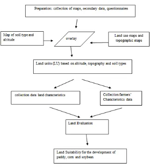
Stages of the study are presented in the following figure 1.
Figure 1: Stages Research
2.1 Collected Data
Collected Data consist of primary and secondary data. Primary data are biophysical, climatic, social and
economic characteristics of farmers. The primary data was obtained through observations and direct
measurements in the field and farmers interview by questionnaire respondents. Secondary data is the general
view of research areas taken from villages and district data, institutions or agencies related reports, maps and
relevant agencies.
2.2 Research Conduction
The first phase aims to make land units from the map overlay. Topographic maps, elevation and soil type map
are used to divide the research area. Based on the altitude, watershed is divided into three areas, namely the
upstream, midstream and downstream. Based on the slope watershed is divided into four zones based on the
division of regions for determination of agro ecological zones, In Zone I the slope is > 40%. In zone III the slope
is 8 -15%. In Zone IV the slope is 0-8% [4]. Soil sampling area is distinguished by the type of soil.
Composite soil sampling was taken on each unit of land as many as the diversity of soil types in that area. The
composite soil samples were taken by drilling the ground as deep as about 0-20 cm from topsoil, then mixed
together and took around 1 kg. Soil was taken from the flat surface, not from a former burnt, and not from the
holes of plants which still contain organic material [8, 17].
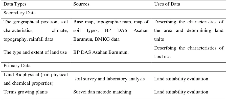
Table 1: Types, Sources and Uses of Data for Land Suitability Evaluation commodity paddy, Corn and Soybean
in Binangalom Watersheds.
Base map, topographic map, map of
soil types, BP DAS Asahan
Barumun, BMKG data
Describing the characteristics of
the area and determining land
units
The type and extent of land use BP DAS Asahan Barumun, Describing the characteristics of
land use
Primary Data
Land Biophysical (soil physical
and chemical properties) soil survey and laboratory analysis Land suitability evaluation
Terms growing plants Survei dan metode matching Land suitability evaluation
2.4 Land Suitability Evaluation.
Land suitability Identification to determine agro-ecological zones used land evaluation according to Land
Suitability Criteria for Agricultural Commodities [7]. Each unit of land maps resulting from the surveying
and/or mapping of land resources, land characteristics can be detailed and elaborated, that includes the physical
state of the environment and the land. Those data are used for the purposes of land interpretation and evaluation
for a particular commodity. Land characteristic data is also used to determine land use suitability classes.
3. Results and discussion
3.1 Layout And Size
Geographically Binangalom watershed lies between 99 ° 0'30,409 "E and 99 ° 6'42,699" E 2 ° East longitude
and 35'53,1 "N to 2 ° 24'24,244" N Latitude North with an area of 3717 , 53 ha. Administratively Binangalom
watershed is located in the Lumban Julu, Toba Samosir District [3], as in Table 2.
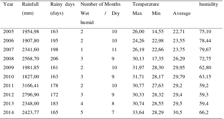
3.2 Climate / Rainfall
Based on Oldeman climate classification [13], climatic conditions in the Binangalom watershed Toba Samosir is
Binangalom watershed range between 1827.00 mm to 3166,41mm. Based on the number of wet and dry months
the types of rain in the Binangalom watershed is rather wet [15]. Some important elements of the climate, such
as: temperature, humidity, and precipitation are presented in Table 3.
Table 2: Area Binangalom watershed
districts Subdistrict Rural Area (ha)
Toba Samosir Lumban Julu
Table 3: Some Elements of Climate average 20 Years (Years 1995-2014).
Year Rainfall
(mm)
Rainy days
(days)
Number of Months Temperature humidity
Wet /
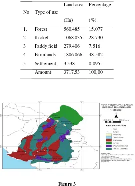
Land use in the Binangalom watershed is dominated by farmland with an area of 1806.066 hectares or about
48.58% of the area of Binangalom watershed.. While the smallest of land use is settlement about 3.538 or about
Table 4: Percentage of Land Use Types in subzone Binangalom
No Type of use
Land area
(Ha)
Percentage
(%)
1. Forest 560.485 15.077
2 thicket 1068.035 28.730
3 Paddy field 279.406 7.516
4 Farmlands 1806.066 48.582
5 Settlement 3.538 0.095
Amount 3717,53 100,00
Figure 3
The application of the farm systems system package should be based on a more comprehensive agro ecological
zone (ZAE) assessment so as to facilitate plant planning and management [1]. The use of Geographic
Information Systems (GIS) has been used for the determination of agro ecological zones of a number of major
crops in nine major regions of Asia, Africa and America in relation to dry weight of harvest [16]. GIS
applications in the commodity zoning have also been carried out by Bhermana and his colleagues
(2004) [6], namely to arrange and analyze the territorial area of Kandul District of North Barito, Central
Kalimantan. The area of rice farming commodities based on GIS-based ZAE has been studied by Nurwadjedi
and his colleagues (2009) [12]
3.4 Evaluation of Land Suitability
Land suitability evaluation begins with a map of homogeneous land units (LU), biophysical characterization of
soil to determine the quality and nature of the soil in each LU, evaluate the suitability of land (to match the
quality and nature of the land to the growing requirements of plants). Map of the land can be used as baseline
data that can be interpreted in accordance with the needs and goals of its development. In agriculture, soil maps
and the level or management system should be implemented. Numbering land units is sorted by type of land and
then based on the degree of slope and altitude. Map of LU is very important as a separation unit of land/land for
the purposes of analysis / interpretation of the potential or suitability for a type of land use. LU is also used as
the basis for selecting the sample, the determining the number of samples, checking the field, soil sampling,
interviewing farmers and guiding respondents. In this study, soil map overlaid with topography map, and
elevation map to get homogeneous LU. From the overlay result 16 LU are obtained. The result is presented in
the form of a map as shown in Figure 2 and detailed descriptions are presented in Table 5.
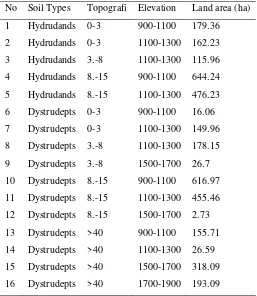
Figure 2: Map of Land Units By overlaying maps Soil type, Topography and Altitude
Table 6: Land Unit by overlaying maps of soil types, topography and altitude
No Soil Types Topografi Elevation Land area (ha)
1 Hydrudands 0-3 900-1100 179.36
2 Hydrudands 0-3 1100-1300 162.23
3 Hydrudands 3.-8 1100-1300 115.96
4 Hydrudands 8.-15 900-1100 644.24
5 Hydrudands 8.-15 1100-1300 476.23
6 Dystrudepts 0-3 900-1100 16.06
7 Dystrudepts 0-3 1100-1300 149.96
8 Dystrudepts 3.-8 1100-1300 178.15
9 Dystrudepts 3.-8 1500-1700 26.7
10 Dystrudepts 8.-15 900-1100 616.97
11 Dystrudepts 8.-15 1100-1300 455.46
12 Dystrudepts 8.-15 1500-1700 2.73
13 Dystrudepts >40 900-1100 155.71
14 Dystrudepts >40 1100-1300 26.59
15 Dystrudepts >40 1500-1700 318.09
Land Area Binangalom Watershed 3717.53
3.5. Agroecology Zone (ZAE)
Agro ecology zone (ZAE) is a grouping of a region based on the physical state of similar environment in which
the diversity of plants and animals is expected to be the same [11]. The main component of agro ecology is the
climate, physiographic and soil. Climate is the most dominant variable in determining the growth of plants. The
main components of the climate in the determination ZAE is air temperature associated with altitude, humidity
and rainfall. Agricultural business is also determined by the shape of the region and soil type. Shape region is
easier to convey with the magnitude of the slope. Soil properties determining farmland is acidity and texture of
soil and drainage [8,14]. The better the state of the land the more alternative crops can be selected. In the
selection of suitable plant to cultivate on an area of land, required input data on a slope, drainage, texture,
acidity, and is equipped with a data regime of humidity or rainfall and the regime of temperature or altitude [9],
because ZAE is one way to organize land use through clustering region on the basis of similarities in the nature
and condition of the region. One purpose of grouping ZAE is to set the area or crop mapping and to improve
commodity in accordance with the capacity of the environment. The increase of crops in accordance with ZAE
will obtain optimal and sustainable farming.
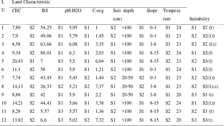
The results of analysis of soil properties and biophysical Binangalom watershed are presented in Table 6. CEC
characteristics of the soil has a low level of acidity in the range of very sour, sour and slightly sour, C-organic is
categorized as low to very high, soil texture is argillaceous sand and sandy clay, and drainage conditions is
good.
Binangalom Watershed has ZAE characteristics as follows:
1. Zone I is a land that has a slope> 40% or a region which is very steep where the slope is not permitted for
cultivation of agricultural crops. Zone I area is ideal for forestry as productive forests or protected forests. There
are several subzones in Zone I, namely: 1) Subzone Y, areas with high rainfall or Moist regime humidity, with
annual rainfall between 1700-2500 mm, 2) Subzone B with area altitude between 500-1000 m above the sea
level (asl) or Cool temperature regime, 3) Subzone 1, a region that has a good drainage conditions.
2. Zone II. It is a zone with the type of land used for plantation/cultivation of annual crops/fruits. Tutorial
utilization is for plantation crops or perennial plants with conservation farming system. Planting without tillage,
minimum tillage and the use of cover crops under annual plants does help to prevent erosion that can lead to
degradation of land quality and environmental damage [2]. Types of commodities suitable for plantations or
perennial crops in this zone are cocoa, coffee, rubber and cotton. This zone can also be directed to the utilization
of limited production forest, with the principles environmentally friendly management. The silvicultural system
(selective logging, planting) can be applied in forest management in a consistent and sustainable, remembering
the soil conditions that is still relatively vulnerable to erosion. With those principle, forest and land
sustainability can be maintained and the production of wood as a source of income for the regional economy
3. Zone III is a land with a slope of 8-15% or land physiographic choppy and somewhat steep slope. The
farming system in zone III is a combination of agroforestry with annual crops and productive food crops, fodder
crops and monoculture food crops by applying conservation technology. Subzone contained in Zone III is 1)
Subzone Y, areas with high rainfall or Moist regime humidity, with annual rainfall between 1700-2500 mm, 2)
Subzone B with area altitude between 500-1000 m above the sea level or Cool temperature regime, 3) Subzone
1, a region that has a good drainage conditions.
4. Zone IV is a land with a slope <8% where the land can be used for planting all kinds of commodities,
intensively either for seasonal or annual crops by using monoculture or intercropping. Land in this zone is flat
land up to rather flat. Subzone contained in Zone IV are: Subzone Y, areas with high rainfall or Moist regime
humidity, with annual rainfall between 1700-2500 mm, 2) Subzone B with area altitude between 500-1000 m
above the sea level (asl) or Cool temperature regime, 3) Subzona 1, a region that has a good drainage.
conditions. Suggested Commodities developed is based on land suitability evaluation in each zone as presented
in Table 8-11 below.
3.6 Land Suitability for Paddy
Evaluation of suitability for paddy was not done at all LU. Land evaluation was performed on LU 1- 12, while
at LU 13-16 were not evaluated because the use of land in LU is for forest. Land suitability characteristics for
each commodity refer to land characteristics according to Djaenudin and his colleagues (2011) [7,5].
Land suitability assessment of semi-detailed level for paddy in Binangalom watershed is presented in the
following table 8:
Table 8: Rating suitability of land for paddy in the Binangalom watershed
CEC: Cation exchangeable capacity, BS: base saturation (f) soil fertility, (t) temperature
3.7 Land Suitability for Corn
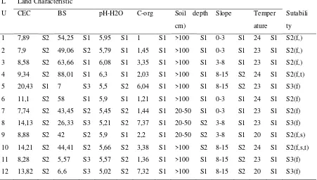
Land suitability assessment of semi-detailed level for corn in Binangalom watershed is presented in the
following table 9.
Table 9: Rating suitability of land for corn in the Binangalom watershed
L
CEC :Cation exchangeable capacity, BS: base saturation (f) soil fertility, (t) temperature, (s) soil depth
3.8 Land Sutability for Soyben
Land suitability assessment of semi-detailed level for soybean in Binangalom watershed is presented in the
following table10.
Factors limiting the suitability of land for paddy, corn and soybeans in binangalom watershed that can be
improved is the C-Organic, and pH.
From Table 8,9,10, it appears that the repairing attempt need to be done on the limiting factors organic C and pH
is by the addition of organic matter and liming.
Thus suitability for nutrient retention can be improved. Actual and potential land suitability after repairing at
Table 10: Rating Suitability of Land for Soybean in the Binangalom Watershed
CEC:Cation exchangeable capacity, BS:base saturation (f) soil fertility, (t) temperature, (s) soil depth
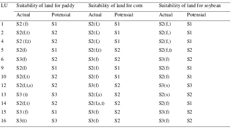
Table 11: Suitability Assessment of Actual and Potential Land for Paddy, Corn And Soybeans
LU Suitability of land for paddy Suitability of land for corn Suitability of land for soybean
Actual Potensial Actual Potensial Actual Potensial
The results obtained wide with GIS analysis of actual and potential land suitability in Binangalom watershed
(Table 12)
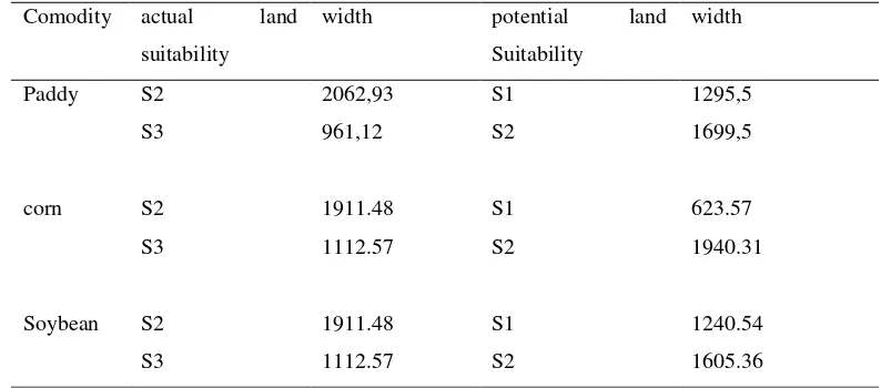
Table 12: Area of Suitability of Land for Paddy, Corn and Soybeans
Comodity actual land
suitability
width potential land
Suitability
width
Paddy S2 2062,93 S1 1295,5
S3 961,12 S2 1699,5
corn S2 1911.48 S1 623.57
S3 1112.57 S2 1940.31
Soybean S2 1911.48 S1 1240.54
S3 1112.57 S2 1605.36
In table 12 it can be seen that the actual land suitability classes for paddy, corn and soybean are quite suitable
class (S2) and the suitable marginal (S3). The suitable class (S1) and quite suitable (S2) can be upgraded by
limiting factor nutrient retention and through the provision of organic materials and liming suitability classes.
4. Conclusion
1. Zone Agroecology in Binangalom watershed classified into four zones, namely Zone I, II, III and IV.
Each zone is divided into sub-zones dominated by sub Zone Y (humid), B (cool) and 1 (good
drainage).
2. Regional Binangalom watershed is potential for the development of paddy, corn and soybeans that is
indicated by appropriate land suitability classes and quite appropriate.
3. Class suitability of land for the development of paddy, corn and soybeans are suitable (S1) and quite suitable (S2) in Binangalom watershed.
Acknowledgements
The author is very grateful for the services provided by Mr. Erwin Masrul Harahap, Mrs.Chairani Hanum, and
Mrs.Rahmawaty, for guidance and direction during the completion of this paper, for Rado Ganda Purba and Arif
Rizaldi for collecting field data during the study period.
[1] Amien .I. Analisis Zona Agroekologi Untuk Pembangunan Pertanian, Pusat Penelitian Tanah dan
Agroklimat. Badan Litbang Pertanian. Bogor. 2000
[2] Asdak, C. Hidrologi & Pengefolaan Daerah Aliran Sungai. Yogyakarta: Gadjah Mada University
Press.2010
[3] BPDAS Asahan Barumun. Rancangan Pembangunan Model DAS Mikro Sub DAS Gopgopan.
Pematangsiantar. Indonesia. 2011
[4] Balai Penelitian Tanah. Petunjuk Teknis Penyusunan Peta Pewilayahan Komoditas Pertanian
Berdasarkan Zona Agro Ekologi (ZAE) skala 1:50.000 (Model 1). Balai Penelitian Tanah,
Puslitbangtanak Bogor. 2001
[5] Balai Penelitian Tanah. Petunjuk Teknis Evaluasi Lahan Untuk Komoditas Pertanian. Balai Penelitian
Tanah, Puslitbangtanak Bogor. 2003
[6] Bhermana, A, R.Massiani dan R. Ramli. Aplikasi Sistem Informasi Geografis untuk penyusunan
dan Analisis pewilayahan Komoditas. Prosiding Seminar Nasional Inovasi Teknologi Sumberdaya
Tanah dan Iklim. 2004
[7] Djaenudin, D., Marwan, H., Subagjo, H., dan A. Hidayat. Petunjuk Teknis Evaluasi Lahan Untuk
Komoditas Pertanian. Balai Besar Litbang Sumberdaya Lahan Pertanian, Badan Litbang Pertanian,
Bogor. 36p. 2011
[8] Hardjowigeno, S. Ilmu Tanah. Akademika Pressindo. Jakarta. 2003
[9] F.A.O, 1983. Guidelines Land Evaluation for Rainfed Agriculture. Soil Bulletin No. 52. Soil Resources
Management and Consevation Service Land and Water Development Division
[10] FAO. Guidelines for Soil Profile Description. Soil Resources Development and Cons. Service, Land
and Water Development Division. FAO/UNESCO, Rome. 1978.
[11] Las, I., A.K. Makarim, A. Hidayat, A. Syarifuddin, dan I. Mawan. Pewilayahan Agroekologi Utama
Tanaman Indonesia. Puslitbangtan, Edisi Khusus, Pus/03/90.Bogor. 1990
[12] Nurwadjedi, B. Mulyanto dan Suwardi. The Assessment of the rice field sustainability in java
base on regional spatial use planning (RSUP). Jurnal Ilmu Tanah dan Lingkungan. 2009.9:80-87
[13] Oldemandan Frere. Report on the Agroecological Zones Project. Vol. 1, Methodology and Result
for Africa. Rome. 1982
[14] Pusat Penelitian Tanah dan Agroklimat & Proyek Pembinaan Kelembagaan Penelitian dan
[15] Schmidt, F.H., and J.H.A. Ferguson. Rainfall Type Based on Wet and Dry Period Ratios for Indonesia
with Western New Guinea. Verh. No.42. Jawatan Met. dan Geofisik, Djakarta. 1951
[16] Shivakumar, MKV dan C. Valentin. Agroecological zones and the assessesment of crop
production potential. Phil. Trans. R.Soc. Lond. 1997. B, 352:907-916
[17] Soil Survey Staff. Keys to Soil Taxonomy, 8th edition 1998. Nasional Resources Conservation