Tale of two cities: Developing city resilience strategies under climate
change scenarios for Indore and Surat, India
Umamaheshwaran Rajasekar1, Gopalakrishnan K. Bhat1, Anup Karanth1
1
TARU Leading Edge Pvt. Ltd, India. E-mail: [email protected]; [email protected]; [email protected]
ABSTRACT: This article discusses the methodology adapted in designing city resilience concepts under changing climate scenarios for two cities in India, namely, Indore and Surat. This initiative was undertaken in the second phase (2009-2010) of Asian Cities Climate Change Resilience Network (ACCCRN) programme (www.acccrn.org). The process of resilience planning has demonstrated how local organizations have used new climate and urbanization information to identify vulnerabilities and capacities to develop integrated resilience plans. Local engagement in the development of the City Resilience Strategies resulted in a much greater understanding of the climate change issues and resilience processes among local and national partners. The strategy provides an overarching framework informed by visioning exercise, hazard risk assessment, vulnerability analysis, sector studies and pilot projects to demonstrate effectiveness of resilience options.
Risk assessment was conducted to get a better understanding of impacts on city. City wide vulnerability assessment was carried out using object oriented analysis techniques to capture current vulnerability of different sections of population across space and socio-economic categories. The issue of climate change is cross-cutting, therefore, sector studies were undertaken to determine the degree to which existing systems can response to varying climatic conditions. The assessment results were integrated to draw an informed resilience approach for the cities in dealing with climate variability and change. Resilience strategy development was informed by climate science, hazard risk information, urban planning/development framework, current vulnerability and anticipated future risks. The resilience strategy is grounded on was resource constraints, economic development and critical uncertainties. Engagement with different institutions was carried out through extensive studies and consolidation from series of risk to resilience (R2R) workshops. This led to the empowerment and ownership by city stakeholders for the resilience strategy.. This study is one of the pioneering efforts towards developing urban resilience strategies under changing climate scenarios for Indian cities. The methodology adapted for the two cities are currently being owned and replicated by other cities in India.
Keywords: city resilience strategy, climate change adaptation, ACCCRN.
1. INTRODUCTION
Asian cities climate resilience network (ACCCRN) is a seven year initiative aimed at building Climate Change Resilience. The programme is spread across cities in four countries (India, Indonesia, Thailand, Vietnam) and works at the nexus of climate change, vulnerable and poor communities, and urbanization. The network consists of partner institutions coming together to solve the larger challenge of addressing the impacts of the currently varying climate and create resilience amongst the city stakeholders (including citizens). The range of problems currently faced by the cities in general includes water security, sanitation, aquifer contamination and saline water ingression, and health risks. These cities are also prone to hydro-meteorological hazards such as cyclones, floods and droughts. The exposure to hazards has increased due to the expansion of cities into higher risk areas. The urban growth rate for 2001 to 2011 was 31.8% while rural growth rate was only 12.2% (Census, 2011). Push migration to cities is one of the dominant features of Indian demographic change. Poverty in general and also differentials in access to life line services is an issue. This existing stress on resources the climate change is going to amplify the existing risks.
Given the existing condition, devising options for resilience is a challenging task and can be achieved only through knowledge about resources, risks, vulnerability and their drivers of change. The 20th century has been a period of greatest warming in at least a thousand years. Such climate variability and change are likely to have an impact on the metabolism of the cities. The IPCC working group (WG) found evidence that recent regional climate changes, particularly temperature increases, have already affected many physical and biological systems. This will have an impact on the human systems. Ability to manage hazard risk especially climate variability and change risks depends on the interaction between resources, economy, institutions and society. Phase –I of the ACCCRN programme focused towards city scoping and selection of partner cities for deeper engagement. TARU undertook detailed opportunity assessment studies in six cities. The study involved understanding vulnerabilities, possible impacts of climate change, hazard risk situation, urbanization process, poverty profile, service delivery efficiency, stakeholder interest and readiness of the city/ city administration to engage with adaptation. Based on this three cities were selected in India and this articles highlights the resilience strategy development for Indore and Surat.
1.1 Urbanization a context for climate change adaptation
infrastructure which is mostly old and was designed for much lower population. Anticipatory planning is severely constrained by shortfall in finance as well as constraints in planning process itself. Few studies of urban metabolism have focused on quantifying the energy in cities, while others have more broadly included fluxes of nutrients, materials and urban hydrologic cycles (Kennedy, 2007).
Rapid urbanization without sufficient investment on infrastructure and services has given rise to increase in the number of urban poor. As per 2001 estimates, the slum population in India is estimated to be 61.8 million. The slum population is around 0.5 million in both Indore and Surat accounting to 27% and 20% respectively. With rising population and increasing demand for space within the urban areas, the poor are forced to settle in risk prone areas. These slums are overcrowded, often polluted, lack access to basic civic amenities such as clean water, sanitation and health facilities. In Indore and Surat even though the slums are scattered across the city, majority of them are located along the vulnerable areas adjoining rivers or drainage causing concern to the urban local bodies (ULB).
The inter-governmental panel on climate change (IPCC) noted different ways in which climate variability and change are likely to affect urban water supply and sewage systems. Increased temperatures are likely to cause increased demand in water. Further, any reduction in local water sources is likely to increase the demand on regional water supplies (Parry et.al, 2007). On the other hand, due to lack of storm water drainage in Indore and Surat, extreme precipitation events are likely to cause urban flooding affecting the low lying areas and poor settlements adjacent to natural drainages.
Indore and Surat primarily depend on water from external resources; Narmada River in case of Indore and Ukai dam/ Tapi River in Surat. Several growth factors such as increasing population, changing land use pattern, change in social attitude/ aspiration and high dependency on water resources for daily activities influence the material inflow and outflow. The stock and flows of resources through the cities, if not monitored, reach critical levels and leads to falling ground water levels, rising energy consumption, accumulation of waste, increase in urban heat island (UHI) effect, degradation in public health among others.
2. METHODOLOGY
The Phase II of the ACCCRN provided an opportunity towards deeper understanding of the city metabolic processes and a gateway to introduce the subject of climate change. A range of collective experiments were undertaken to improve the ability of the city, its stakeholders to withstand, prepare for, adapt and build resilience from the projected impacts of climate change. The intervention in the city of Indore and Surat spans across a range of activities. This includes:
Setting up city advisory committee to guide and implement the process, sustain the activities and mainstream it in ongoing course of development activities
City visioning exercise with intermittent goals for the year 2030; sector specific vision goals along with generation of ideas to address climate resilience.
Develop tools/methods and conduct of city wide vulnerability and capacity assessment
Undertake series of consultation meetings with stakeholders to initiate the dialogue on cc issues and its impacts, changing discourse from business as usual (BAU) approach to dealing with uncertainty (in an year of continuous engagement with the
stakeholders of Surat, the city is setting path towards “Living with floods”)
Engage with the city stakeholders and catalyze their capabilities (All key sector study reports were undertaken with the engagement of the city stakeholders)
Screening programmes and plans for urban environment / planning / development/urban transport, sector studies on water security/energy security/public health among others, flood risk management and development of sector adaptation matrix
Deal with multiple stakeholders and initiate the debate to leveraging the capacities which are dormant, create local ownership along with the platform for engagement
Conducting Risk to Resilience workshops, thereby enabling the city stakeholders to participate in scenario planning and identifying the indicators for the same, identify list of short and medium term resilience based interventions, development of city resilience strategy and city resilience plan.
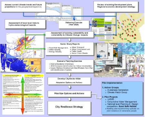
Changing the world-view map (paradigm shift) and introducing framework for city planning incorporating resilience Figure 1 illustrates the methodology adapted for the city resilience strategy development.
2.1 Climate change analysis
and the results for base climate information for the years 1960 to 1990 was compared with the observed temperature and precipitation results obtained from Indian Meteorological Department (IMD) station data located within and nearby each city. The models which were found to provide similar results were selected. The results were bias corrected and were used for climate change prognosis.
2.2 Visioning
Visioning exercise was conducted within the city to provide the pathway for development. The vision for 2025 was created for each city by the city stakeholders while the moderation of discussion was done by TARU.
2.3 Stakeholder consultation
A series of one on one consultation were held with various city stakeholders in each of the cities. Regular city advisory committee (CAC) meetings were also held at each of the cities to exchange information regarding climate change risks, the key uncertainties and city level resource, infrastructure, services and vulnerability issues. These consultations provided opportunities for exchanging and updating information at various levels. Household and community level questionnaire were developed by the team and shared with the stakeholders and their comments were sought for improving the quality of survey tools. The climate projections were discussed in the CAC meetings with description of uncertainties that can be expected due to the limitation of models and the level of knowledge about climate especially in areas without sufficient past data. The CAC also discussed their experience about the changes during last few decades. For example in Indore the CAC members mentioned about past pattern of rainfall dominated gentle showers for days, while now they face heavy downpours. They also reported about the pleasant
evenings of Indore known as Shab’e’ Malwa, while now the summer nights are hot and unpleasant.
2.4 Risk Assessment &Vulnerability Assessment
Risk assessment was done based on past event history from household surveys and validated by flood submergence maps of the city. Also potential areas prone to storm surges and high tides were derived from Shuttle Radar Topographic Mission (SRTM) elevation data of the undeveloped parts of Surat. The past temperature and precipitation data from Indian Meteorological Department was used to understand the past trends.
Collection of data especially relating to the vulnerability assessment does not fall within the scope of the National decadal Census survey or any other survey done by the government in India. The application of vulnerability analysis within this study included the integration of neighborhood level information on human, environmental and social parameters ranging from household to neighborhood levels and aggregation to city administrative subunits and city level. Also, ecological factors like terrain, distance from natural drainage that are embedded in the landscape contribute in different ways to the overall vulnerability pattern that modify risks as well as service levels (e.g. through water supply, drainage). These ecological factors reflect, in varying degrees,
people’s resilience and ability to cope with and recover from losses. They also provide a means to understand differential vulnerability within and between urban places.
The method used for this study involved stratified sampling for data collection through questionnaire based survey was designed and implemented GIS enabled sampling and aggregation method was used to analyze the vulnerability. This method (titled as GEOPSY) involves delineation of the whole city in to homogeneous polygons based on roof types, density, road width and other visually distinct parameters. For example, in Indore 945 polygons were drawn with average polygon area of 10 hectares. High resolution satellite imagery of 1 m resolution was used to draw the polygons in a GIS platform. Attributes including, type of houses average number of stories, type of resident socioeconomic classes were collected through a GPS enabled reconnoiter across the whole city. Household and community level surveys were conducted to elicit information on various issues covering household size, member details, occupation, incomes, expenditure, water, sewerage, and electricity solid waste collection infrastructure, assets (vehicles, appliances), health, floods water scarcity and other common risks, coping strategies etc. For the purpose of analyzing the vulnerability (3 indicators) and capacity (3 indictors), a total of six indicators were selected. These indicators depend on a set of key sub-indicators and mostly equal weights were given to each sub-indicator. This method reflects different facets of vulnerability as well as effective in comparing differential vulnerability across SECs and space. Since each of the indicators is presented separately, the adaptation plans can be developed to address each facet of vulnerability separately to achieve desired minimum benchmarks.
2.5 Infrastructure Service Deficiency analysis
Infrastructure deficiency analysis (ISDA) was done based on the Geopsy transects and aggregation. Water supply, sewerage and drainage were mainly covered. The data was aggregated to city level using the methods already explained earlier. The spatial distribution of infrastructure and service delivery is presented in set of indicators and maps.
2.6 Spatial data aggregation and map generation
Data aggregation was done from household level to polygon levels. From the polygon level, population density and indicated data was transferred to nearest similar polygons by distance query using GIS. These polygon level population data was used to project and develop city level outputs.
2.7 Sector Studies
Sector studies (Environment, Flood Risk and Management, Health, Energy Security, Green Buildings, Urban Transport, Water Security) were undertaken to determine the degree to which existing systems can adjust in response to, or in anticipation of, changed climatic conditions. The assessment results supported to draw an integrated resilience approach for the city of Indore and Surat in dealing with climate variability and climate change. To effectively address the challenges that a changing climate will bring in the near future, the local government understands that urban policies/growth must complement with the adaptation/mitigation action & efforts are synchronized towards the goal of achieving resilience.
2.8 Risk to Resilience workshops/Consultation meetings
2.9 Issues-Impact Matrices
This tool was essential used to summarize the understanding and the inter-linkages between urban growth scenarios, urban systems, current status of growth and urban systems, future trends without climate change and with climate change scenarios in the city.
2.10 Development of City Climate Resilience Strategy and prioritization of actions
The City Resilience Strategy (CRS) is an attempt to put together the findings of city risk and vulnerability to climate change impacts, the risks and challenges likely to be posed to the city of Surat by the processes associated with climate change, the likely
impacts on crucial sectors of city’s socio-economic life and the identification of short-medium and long term strategies to be implemented in the city. The resilience strategy is structured around four major principles:
Build on current and planned initiatives
Demonstrate resilience building projects to leverage further action
Multi-sectoral information generation and shelf of projects
Build synergy with state and national level institutions
3. OUTCOMES
Cities now house more than half of the global population, including hundreds of millions of poor and marginalized households, making it essential that steps are taken to increase the resilience of cities and the communities within them to withstand the shocks and stresses spurred by climate change. Climate change is one of the most pressing challenges of the present century.
Though it’s a global problem, actions need to be taken locally to help communities prepare for and weather climate-related impacts. The stakes for cities are particularly high given its strong economic base and rapid growth.
The Climate Resilience Strategy for Indore and Surat is draws upon two years of action research study. This strategy reflects a tremendous amount of leadership, effort and dedication shown on the part of the city and wide range of institutions and individuals within it, from government, business, academia, technical centers and civil society.
ACCCRN has taken up action research approach and the program also supports implementation of a range of local driven resilience projects. Gorakhpur, Indore, and Surat are among the first generation cities in India to have developed a comprehensive action research oriented Climate Resilience Strategy. These cities have already been recognized as leaders in strengthening urban resilience to climate change. At present the cities continue to implement resilience projects and are also serving as a model for replication and sharing knowledge to less informed cities.
The city resilience strategies can be assessed at the following location on the web:
Surat: http://www.indiaurbanportal.in/Publications/Publications141/Publications141672.PDF
Indore: http://www.imagineindore.org/resource/30.pdf
4. ACKNOWLEDGEMENT
The authors wish to thank The.Rockefeller Foundation, the Municipal Corporation of Indore and Surat, Members of the City Advisory Committee and all stakeholders of ACCCRN program involved in the development of the City Climate Resilience Strategy and implementation of resilience interventions.
5. REFERENCES
Census (2011), Census of India, Government of India.
Kennedy, C. (2007), 'Urban metabolism', Technical report, Encyclopedia of Earth.