Building Climate Resilience to
Noapara Town
A Coastal Urban Centre of Bangladesh
About the authors
Sarder Shaiqul Alam, Principal Investigator, Urban Climate Change Group, International Centre for Climate Change and
Development (ICCCAD) Email: [email protected]
A. T. M. Jahangir Alam, Researcher, Urban Climate Change Group, International Centre for Climate Change and Development (ICCCAD)
Email: [email protected]
M. Feisal Rahman, Research Oficer, Urban Climate Change Group, International Centre for Climate Change and
Development (ICCCAD) Email: [email protected]
Sowmen Rahman, Research Assistant, Urban Climate Change Group, International Centre for Climate Change and Development (ICCCAD)
Email: [email protected]
Niaz Rahman, Research Assistant, Urban Climate Change Group, International Centre for Climate Change and Development (ICCCAD)
Email: [email protected]
Acknowledgements
The authors are grateful to the International Institute for Environment and Development (IIED) for supporting the study by the International Centre for Climate Change and Development (ICCCAD) at the Independent University, Bangladesh
(IUB). We are grateful to the Noapara municipality oficials, government oficials, town planners, non-government
organisation representatives, community members, and others who provided support during the collection of data. The
authors also wish to thank the reviewers of this working paper from the ICCCAD, especially Dr Saleemul Huq, Director
Contents
About the authors 2 Acknowledgements 2
Abstract 5
Acronyms 6
1 Introduction 7
1.1 Background and rationale 7
1.2 Research objectives 8
1.3 Structure of the report 9
2 Literature Review 10
2.1 Vulnerability of coastal zones to climate change 10
2.2 Vulnerable groups 11
2.3 Climate change and migration 11
2.4 Resilience in coastal urban centres 11
3 Methodology 13
3.1 General introduction 13
3.2 Selection of study sites 13
3.3 Key Informant Interviews (KIIs) 14
3.4 Focus Group Discussions (FGDs) 14
3.5 Consultation workshop 14
3.6 Analysis of data 14
4 Study Area 15
4.1 Reasons for selecting Noapara as a study site 15
4.2 Geography 15
4.3 Demographics 17
5 Climate Change and Water Sanitation 19
5.1 Present status of water in Noapara municipality 19
5.2 Present status of sanitation in Noapara municipality 19
5.3 Vulnerability of Noapara due to climate change 20
5.4 Impact of climatic hazards on water infrastructure and services 21
5.5 Impact of climatic hazards on sanitation infrastructure and other services 22
5.6 Climate change and livelihoods 22
5.7 Climate change and migration 23
6 Building Resilience in Water and Sanitation 24
6.1 Institutional and policy analysis in urban climate resilience in Bangladesh 24
6.2 Integrated approach 25
6.3 Inward migration to Noapara 30
7 Conclusion 31
Abstract
This paper attempts to identify ways of making the town of Noapara, a coastal
urban centre in the Jessore district in Bangladesh, resilient to the impacts of climate
change, with speciic focus on the water and sanitation sectors. Climatic events can
trigger migration from hazard-prone areas to large cities. But if suficient livelihood
opportunities are available, improved resilience of towns or urban centres close to
major cities may play a role in diverting migrants from the large cities. The situation in
Naopara was investigated to see what investments would need to be made in the town to
make it an attractive option for migrants.
The indings indicate that Naopara lacks access to basic services such as safe water and
sanitation, with only one per cent of households being covered by the municipal water
supply. The rest are dependent on hand tube wells and other sources. In particular, poor
communities lack access to safe water because they do not have their own land, or
the economic capacity to afford a tube well. Additionally, the lack of proper drainage
systems, adequate sanitation facilities and waste management facilities increases the
vulnerability of those communities during hazards. Climate change-induced hazards
such as intense rainfall, cyclones, looding and salinity intrusion are expected to
Acronyms
ACCCRN Asian Cities Climate Change Resilience Network
ADB Asian Development Bank
BCCSAP Bangladesh Climate Change Strategy and Action Plan
BWDB Bangladesh Water Development Board
CBo Community-based organisation
CRI Climate Risk Index
DoE Department of Environment
DPHE Department of Public Health and Engineering
EIA Environmental Impact Assessment
FGDs Focus Group Discussions
ICCCAD International Centre for Climate Change and Development
IIED International Institute for Environment and Development
IPCC Inter Governmental Panel on Climate Change
KII Key Informant Interviews
MoEF Ministry of Environment and Forest
NAPA Bangladesh’s National Adaptation Programme of Action
NGo Non-governmental organisation
1 Introduction
1.1 Background and rationale
Coastal regions in low-lying countries are highly vulnerable to the impacts of climate change such as sea level rise, coastal inundation, erosion, cyclones and saline water intrusion. Bangladesh is situated in one of world’s low-lying areas, and
the coastal zone of the country is at severe risk of climatic disasters. The global Climate Risk Index (CRI) 2014 identiied Bangladesh as being among the top ten most vulnerable countries, and it was ranked ifth in terms of death toll, losses and number of extreme events in the ten years between 1993–2012 (Kreft and Eckstein, 2014). Under the inluence
of the changing climate, the incidences of extreme weather events are expected to rise and will affect livelihoods in many countries.
These sorts of environmental changes affect patterns of human movement, and developing countries have been the most severely impacted by climate-induced migration (IoM, 2010). According to Walsham (2010), the primary destination for most of Bangladesh’s climate-induced migrants is the country’s urban slums, particularly in the capital city of Dhaka and other large cities such as Khulna, Chittagong and Rajshahi. This migration has resulted in increased population pressure in the major urban areas. But if people were able to pursue livelihood opportunities and access basic utilities and services in alternative nearby urban centres, they may be less likely to migrate to large cities. If this was the case, it could help reduce pressure on Dhaka’s utilities and land resources.
As in other countries, there has been growing concern in Bangladesh about addressing climate change impacts in urban areas. This concern has prompted a number of discussions around urban climate resilience. Kernaghan and da Silva (2014) referred to urban climate change resilience (UCCR) as a process “to catalyse awareness about climate change impacts in urban environments and to initiate processes that enable cities to adapt and become more resilient, thereby reducing risk”.Most research on the topic indicates that a holistic, multi-sectoral approach is necessary to make a city resilient to
the impacts of climate change. It has been found that “the people who have better access to adequate food, clean water,
healthcare and education will inevitably be better prepared to deal with stress including that arising from climate change” (Dodman et al., 2009: 154).
It has been acknowledged that a lack of basic utility services increases the vulnerability of the poor to the impacts of
climate change (Baker, 2012; Huq et al., 2007) and more focus is often given to water and sanitation issues in urban settlements. Baker et al. (2012: 129) noted, “of all basic services, water, sanitation and drainage have received more attention in the context of climate change adaptation and disasters because of their direct bearing on human health”. This is also true in coastal Bangladesh, where the poor suffer from a lack of basic utility services – primarily water and sanitation.
urbanisation and climate change; and Parvin et al. (2013) explored the impact of climate change on the urban poor from the perspective of the built environment and suggested ways of enhancing their resilience capacity. In relation to coastal cities, Rejve (2006) documented the changing livelihood patterns of coastal people living in water-logged areas; Islam et al. (2014) found that direct discharge of domestic sewage and solid waste into surface drains is one of the major problems faced by the sanitation sector in Khulna city; and Jahan et al. (2012) examined how low-income groups developed their climate change adaptive capacity by analysing the impacts of climatic disasters such as cyclones Aila, in 2009, and Sidr, in 2007.
Most of these (Rejve, 2006; Kumar et al., 2011; Islam et al., 2014) were impact studies. other studies (ADB, 2011; Parvin et al., 2013) suggested how resilience could be improved in the water and infrastructure sectors in large cities. In Bangladesh, population increases in large cities, which are already overburdened, would lead to failure of the city governments to provide basic services to even higher numbers of inhabitant. Alam et.al. (2015) noted that Dhaka city’s population increased at a rate of 6.9 per cent which is the highest in the world, growing from 2.2 million in 1975 to 12.3
million in 2000. A signiicant fraction immense population live without any necessary risk reducing infrastructure, due to
unplanned urbanisation and a geographical location that makes the city very susceptible to climatic disasters.
Building the resilience of cities/towns near large cities might reduce the pressure on those larger cities. The literature suggests that potential migrants stop in sub-terminal/intermediate locations before reaching the vulnerable and already overpopulated big cities (Moench and Gyawali, 2008). Such intermediate locations, which are likely to be the nearby towns and municipalities of climate-affected areas, are under-studied in Bangladesh. Climate-related research has so far been conducted either on climate-induced migrants’ origins (Black et al., 2013) or on their inal destinations (Adri, 2013). This study will address new and intermediate locations along existing migration corridors and will attempt to suggest strategies for establishing resilient utility services in those areas, in order that they may be more attractive to climate-induced migrants.
1.2 Research objectives
The main objective of the research is to identify ways of making coastal urban centres resilient to the impacts of climate
change, with speciic focus on the water and sanitation sectors. The primary hypothesis is that, given there are available
livelihood opportunities, improved resilience of towns or urban centres close to major cities, through appropriate policies and planning, may play a role in diverting migrants from larger cities, and that such improvements will naturally pull people to intermediate cities. This study uses the town of Noapara as a case study of a potential intermediary town, which
might attract environmental migrants. The speciic objectives are:
1) To understand how climate-induced hazards are affecting the sanitation and water supply systems in the town of Noapara in Bangladesh.
2) To propose a resilience plan for Noapara to improve provision of utility facilities.
To reach these objectives the report focuses on the following speciic research questions:
a. How is the study area, the town of Noapara, vulnerable to the impacts of climate change?
b. How do these vulnerabilities impact the sanitation and water services in the study area?
c. How do sanitation and other urban services impact the quality of life and choice of migration of the urban poor? d. How can the quality and provision of utility services be improved?
1.3 Structure of the report
This working paper is divided into seven chapters. The second chapter of the report reviews the vulnerability of Bangladesh’s coastal zone to climate change impacts. It also reviews the ways in which resilience can be brought to a coastal urban centre such as Noapora.
The third chapter describes the methodology used in the data collection and analysis, while the fourth chapter provides an overview of the study area and describes the reasons for selecting Noapara as a study site.
The ifth chapter assesses the climate change vulnerability of the study area as well as the impact of climatic hazards on
the water, sanitation and livelihoods of the local community. The role of climate change on migration is also discussed in this chapter.
Chapter six identiies the key organisations and policies that are important in terms of climate resilience planning in the
study area, in particular, and Bangladesh, in general. The chapter also suggests a few key recommendations, which are important for climate resilience.
2 Literature Review
2.1 Vulnerability of coastal zones to climate change
Bangladesh is vulnerable to climate change in part because it is a deltaic coastal country. In recent years, the magnitude
and recurrence of climate-induced disasters such as loods, cyclones, droughts, river erosion, salt-water intrusion and its biological effects have increased signiicantly (Roy, 2011; Minar et al., 2013).
The southwest coastal region of Bangladesh is highly vulnerable because of the combined effects of climate change, sea level rise, subsidence and changes in upstream river discharge. As a result, cyclones, water logging and salinity intrusion are likely to worsen (MoEF, 2005; MoEF, 2009; Minar et al., 2013; IPCC, 2014). The Asian Development Bank (ADB,
2008) identiied several problems in coastal urban centres, including water logging due to lack of drainage capacity, lack of safe drinking water, lack of fresh water due to saline water intrusion, looding as a result of intense rainfall, and
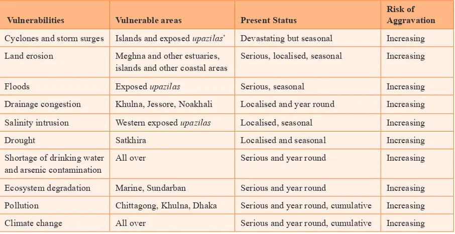
inappropriate disposal of waste and sewage into nearby water bodies. Scientists also anticipate that the present problems will worsen as a result of climate change and sea level rise (Dodman and Satterthwaite, 2008). Table 1 describes the vulnerabilities in different areas of Bangladesh.
Table 1. Climate vulnerabilities in different areas of
Bangladesh
Vulnerabilities Vulnerable areas Present Status
Risk of Aggravation
Cyclones and storm surges Islands and exposed upazilas* Devastating but seasonal Increasing
Land erosion Meghna and other estuaries, islands and other coastal areas
Serious, localised, seasonal Increasing
Floods Exposed upazilas Serious, seasonal Increasing
Drainage congestion Khulna, Jessore, Noakhali Localised and year round Increasing
Salinity intrusion Western exposed upazilas Localised, seasonal Increasing
Drought Satkhira Localised and seasonal Increasing
Shortage of drinking water and arsenic contamination
All over Serious and year round Increasing
Ecosystem degradation Marine, Sundarban Serious and year round Increasing
Pollution Chittagong, Khulna, Dhaka Serious and year round, cumulative Increasing
Climate change All over Serious and year round, cumulative Increasing
2.2 Vulnerable groups
According to Huq et al. (2007), the people most at risk from the impacts of climate change are those who live in hazard-prone areas and who are least able to avoid the direct and indirect impacts of climatic disasters. These people typically
lack good-quality homes, sanitation facilities and drainage systems. They cannot afford to move to less risky places, or are
unable to change their occupation if a climatic hazard threatens their livelihoods. Low-income groups are most vulnerable
to climate change – especially low-income residents who live in urban areas, since they typically have low-quality housing, poor sanitation and drainage facilities (Huq et al., 2007; Baker, 2012).
2.3 Climate change and migration
Reuveny (2007: 657) identiied three different coping mechanisms regarding the environmental problems arising from
climate change: “Stay in place and do nothing, accepting the costs; stay in place and mitigate changes; or leave affected areas.” Developed countries can reduce the threat of potential hazards by developing new technologies or strengthening infrastructure and capacity development. But in developing countries this may not always be possible due to a lack of
appropriate inancing mechanisms, technologies and expertise, which eventually can trigger migration from the affected
areas (Reuveny, 2007). Generally these people migrate to the urban areas that are economically developed and offer income generation opportunities (Tacoli, 2009). This is also common in Bangladesh. Every year around 200,000–225,000 people migrate from different parts of the country to urban centres due to different kinds of disasters such as erosion, salinity, storm surges and water logging (Ahmed and Neelormi, 2008; Akter, 2011). Most of these people end up in urban slums without appropriate shelter, sanitation and security of tenure (Akter, 2011). As a result, hardship increases for both new and older urban inhabitants because of the limited resources available (Akter, 2011).
2.4 Resilience in coastal urban centres
The coastal areas of the world are frequently affected by extreme events and climatic hazards. The severity of the impact
depends on the ability of the system to minimise loss, which, in turn, depends on its resilience (Minar et al., 2013). Revi et al. (2014) deines urban climate resilience as a way to build the systematic capacity of an urban centre so that infrastructural development and land use management reduce the impact of particular hazards. Dickson et al. (2012: 18)
deine resilience as “the ability of a system to withstand or accommodate stresses and shocks such as climate impacts,
while still maintaining its function”.
In recent years, a considerable amount of literature has emerged addressing resilience to climate change for urban centres and the factors that contribute to resilience (Muller, 2007; Leichenko, 2011; Moench et al., 2011; Pelling, 2011; Brown
et al., 2012; da Silva et al., 2012). According to these studies, several systematic characteristics contribute to a city’s
resilience. These are: “lexibility, redundancy, responsiveness, capacity to learn and safe failure” (Tyler et al., 2010; Moench et al., 2011, Brown et al., 2012; da Silva et al., 2012 and Revi et al., 2014: 548). A climate-resilient city not only has the ability to recover from the impacts of climate change, but also the ability to avoid, and the capacity to withstand,
unexpected or unpredicted changes. Resilient cities also require coordinated actions by institutions working in the same area or, alternatively, government action at high levels to reduce the risk of looding by managing the watershed upstream
Considerable work has been devoted to developing frameworks for resilient cities (Brown et al., 2012; ADB, 2014; Kernaghan and da Silva, 2014; Arup, 2014; Tyler and Moench, 2012). Most of these papers suggest that it is a complex process to make a city resilient and that several critical factors should be considered while making a resilience plan. Kernaghan and da Silva (2014) analysed the resilience status of 11 cities in four different countries and proposed 12 building blocks for sustainable urban climate change resilience. These include: knowledge; engaged government leaders, academics, the private sector and civil society; the existence of enabling and supportive national policy and plans;
adequate city/municipal budgets; accessible donor inance; and private sector participation. Given the complexity of city
resilience, an integrated approach is necessary along with participation at all levels to prepare and effectively implement a
3 Methodology
3.1 General introduction
The methodology of this study involved collecting and overlaying ive layers of information in two steps. In the irst step,
secondary data was collected from books, journal articles and reports from government and non-government organisations in order to conceptualise terms such as climate resilience and to develop the tools for primary data collection. The second
step involved gathering qualitative data through a mixture of research techniques including Key Informant Interviews (KII) and Focus Group discussions (FGDs). The initial indings were presented to the stakeholders in a workshop
for validation.
3.2 Selection of study sites
An exploratory study was carried out in the Noapara municipality to accomplish the following:
■
■ To get an overall picture of Noapara municipality
■
■ To understand the infrastructure, housing and land use pattern in Noapara
■
■ To determine the location of the lowest income groups
■
■ To identify the areas that are most prone to climatic hazards
■
■ To identify the areas where water supply, drainage and sanitation facilities are scarce
The reasons for selecting Noapara as the study site are discussed in section 4.1. There are nine wards (the lowest
administrative unit of a municipality) in Noapara. After a two-day ield observation and the cross-checking of observations
through consultation with key informants and a local NGo called Nobo Diganto, the study team chose ward number six for further data collection through key informants from the community. The ward selection criteria were:
1. High density of low-income residents
2. Poor water and sanitation conditions
3. Prone to climatic hazards
3.3 Key Informant Interviews (KIIs)
KIIs are qualitative, in-depth interviews with individuals, including community leaders, professionals, government and non-government organisation representatives or residents, who have irst-hand knowledge about the issues related to the
research topic. The selected key informants have knowledge about the community, its residents, climate change, water and sanitation. To identify individuals with this knowledge, a list of potential key informants was prepared, and a diverse set of representatives with different backgrounds and from different groups were listed. To carry out the KIIs two different
checklists were used, one was for the local residents and another one for government oficials, representatives of local
NGos, representatives of local governments and so on. A total of 30 key informants were selected from the community, which included representatives from climatically and economically vulnerable groups, with 17 male and 13 female participants respectively. In addition to the participants from the community, another nine key informants were selected
from city corporations, town planners, government oficials and non-government organisations; seven of these were male
and two were female.
3.4 Focus Group Discussions (FGDs)
Different aspects of climate change-induced vulnerability and impacts of these climatic extreme events on livelihoods were discussed during the FGDs. Efforts were made to have FGD sessions with climatically and economically vulnerable groups as well as with the low-income women of the study area. A total of 12 FGDs were conducted in the Noapara
municipality. Male and female FGDs were conducted separately, and the locations were based on study site speciications.
The number of participants in each of the FGDs ranged from eight to 15. A FGD session was also conducted that included representatives of NGos working in the Noapara municipality.
Both the FGDs and KIIs were conducted to answer the following research questions: 1) What is the study area’s
vulnerability to climate change? 2) What are the impacts of climate change on sanitation and other urban services? 3)
What are the impacts of climate-affected services on quality of life? 4) What are the migration choices of the urban poor?
5) How can the situation caused by climate impacts be improved in Noapara municipality?
To ensure participation and appropriate understanding of the climate change context, the discussion was framed in terms
of climate variability, frequency and intensity of extreme events.
3.5 Consultation workshop
A stakeholder consultation workshop was also organised in the meeting room of Noapara pourashava (municipality) with the presence of the chairman of the upazila (sub-district) parishad (elected body) and the administrative head of the
upazila. In the stakeholder consultation meeting, representatives from local NGos, elected representatives of the local
government, community people and government oficials were present. The ICCCAD team presented the key indings of the KII and FGDs in the workshop and presented some questions to the audience to validate these indings.
3.6 Analysis of data
The qualitative data generated by the FGDs, KIIs and stakeholder consultations was analysed using the “relexive iteration” method (Srivastava, and Hopwood, 2009) whereby the data was continuously revisited to identify and reine
4 Study Area
Noapara pourashava, a municipality of Abhaynagar upazila in the Jessore district under the Khulna division, is recognised for its river port, industries and commercial establishments. The municipality is by the Bhairab river. The Noapara
pourashava is a Class “A” pourashava, which has a total of nine wards. Wards 4, 5 and 6 are situated in the town. The other wards are primarily rural. This municipality is attractive to many migrant communities in coastal regions because of its employment opportunities.
4.1 Reasons for selecting Noapara as a study site
The southwest coastal region of Bangladesh was chosen for the study because it is highly vulnerable to water logging, salinity intrusion, cyclones and storm surges, all of which are likely to be exacerbated by the impacts of climate change in the future (IPCC, 2014). There were several compelling reasons to select Noapara municipality as the study area.
The Noapara municipality is located in the interior coastal zone of the country, which has a lower vulnerability than the exposed coastal zone. There is evidence that potential migrants go to several intermediate locations before reaching the vulnerable and already overpopulated big cities (Moench and Gyawali, 2008) such as Dhaka. Noapara pourashava is one such intermediate location, which is linked to other urban areas of the country by road, rail and river transportation systems. In the Noapara area, intense commercial activities exist alongside agricultural activities. Moreover, there are an
adequate number of jobs for day labourers, which is the type of work often sought by rural migrants. As a newly growing
industrial hub, there are an increasing number of industries, which enhance job opportunities. In addition, long-term
planning for urban management is necessary, as few interventions have taken place. But there is still insuficient inancial,
technical and human resource capacity, so government initiatives are needed to implement the city development plans.
Climate-related research has so far been mainly conducted either in the origins (Black et al., 2013) or in inal destinations
(Adri, 2013) of climate change induced migrants. Therefore, this particular study will attempt to address such new and intermediate locations of the migration corridor and to suggest approaches to develop resilient utility services in those areas.
4.2 Geography
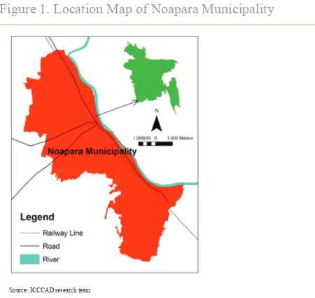
Noapara is located on the western side of Bhairab river (Figure 1) and measures about 25.12km2. The municipality is
connected with all parts of Bangladesh by rail, waterways and roads. It is about 30 km from the district headquarter, the
Figure 1. Location Map of Noapara Municipality
Source: ICCCAD research team
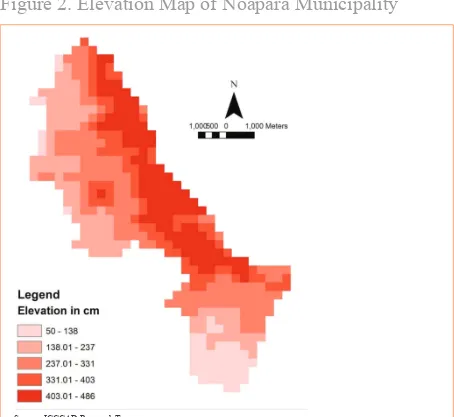
Figure 2. Elevation Map of Noapara Municipality
Source: ICCCAD Research Team
4.3 Demographics
According to the Bangladesh Population and Housing Census 2011, the total population of Noapara is 85,856 (BBS, 2012). About 50.56 per cent is male and 49.44 per cent is female, compared with the national population, which is 50.66 per cent male and 49.94 per cent female (BBS, 2012). The population density of Noapara is 3,314 people per km2.
4.4 Economic activities
Because of its locational advantages and spatial characteristics, Noapara has the potential to develop as a trade and
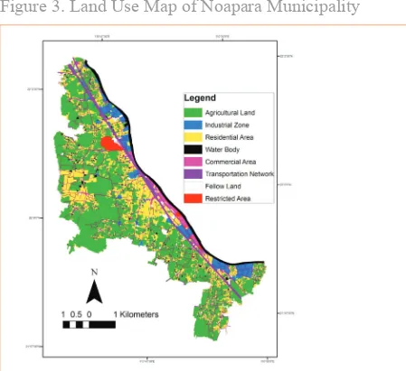
Figure 3. Land Use Map of Noapara Municipality
Source: Data collected from Noapara urban planning ofice (personal communication)
Most of the area is used for agriculture, but alongside the Bahirab river there are jute mills, textile mills, rice mills, paper
mills, leather factories and cement factories (Figure 3). There are 38 industries — 26 are large, ive medium and seven
5 Climate Change and Water
Sanitation
5.1 Present status of water in Noapara municipality
The main source of water in the town is ground water or surface water, which is supplied to the community either through
pipelines or tube wells, and sometimes through dip tube wells. The poor people living in the villages collect their required
water from the hand pump tube wells, rivers or ponds directly. The existing water line is only 15km long and is run through only two water pumps. According to the participants of the stakeholder FGD, only one per cent of the people living in the municipality get their water supply through pipelines.
There is an acute shortage of safe and fresh water in the municipality, especially in the low-income settlements. Locals explained that they usually do not get safe drinking water from tube wells due to high concentrations of naturally occurring arsenic. The water level of the river Bhairab is decreasing due to siltation and the drainage system of the area is poor. only a few areas near the Bazaar and Noapara towns have drainage facilities. The existing drains are seldom cleaned. Additionally, some low-income houses are constructed over the drain because there is a lack of space. This interrupts the draining of rainwater, causing or aggravating inundation. People living along the railway line suffer the most due to water logging, but a drainage line recently constructed on the eastern side of the railway line has reduced water logging to a limited extent. Since there are no solid waste collection services, people often throw waste in the streets and
drains, which blocks the drainage of water. Stagnant water causes environmental hazards such as the breeding of mosquito
and other insects.
5.2 Present status of sanitation in Noapara
municipality
High- and middle-income residents of the town have safe sanitation through the provision of pucca latrines (made of
Another type of latrine is made with rings of concrete slabs for the storage of excreta; these need to be cleaned regularly every three to four months and slum dwellers pay for the associated expenses. Sacks of cloth or sheets of tin are used as the fence for those latrines.
The sanitation conditions are particularly unhygienic in the low-income settlements due to the absence of a sanitation management system. Hanging latrines and open defecation cause serious environmental pollution problems in the Bastuhara slum area. The slum dwellers report that waste from the high-income areas is being piled up indiscriminately near the slum. This causes foul odour and severe pollution, which contaminates water during periods of water logging. Neither government bodies nor NGos are currently monitoring the sanitation of the slums.
5.3 Vulnerability of Noapara due to climate change
According to the community, the severe climatic hazards that frequently occur in this area are torrential rainfall, water logging and storms. The area also experiences the hazards caused by loods, heat waves, cold waves and drought. These
climatic hazards more or less hamper their lives and livelihoods. Some people, mostly those who are active in NGos and community-based organisations (CBos), are directly aware of climate change. However, to improve understanding
of climate change, the focus group discussions were framed in terms of climate variability, frequency and intensity
of extreme events. The community members noted that they have generally been aware of changes in weather and the onset of the seasons. All of the community residents interviewed responded that the area is vulnerable to climate change impacts.
The respondents of the KIIs stated that they have recently been observing more frequent climatic hazards, such as
increasing intensity of torrential rainfall and decreases in the number of rainy days. Around 23 per cent of the KII respondents stated that water logging is the result of this increasing rainfall within a short span of time. Sometimes
excessive rainfall creates looding. This trend of increasing rainfall patterns was also shown by analysing historical rainfall
data from two nearby meteorological stations at Khulna and Jessore (Figure 4). This increasing pattern of rainfall may
create more severe looding in the future. According to the report of World Bank (2000), a ive per cent increase in rainfall
could lead to an increase of up to 20 per cent in the area being inundated.
Figure 4. Trends of Annual Rainfall in Jessore and Khulna
Monitoring stations, which are about 30km from Noapara
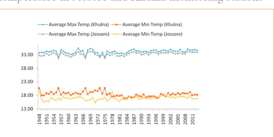
According to local people, they are experiencing changes in weather patterns: the summers are becoming hotter and the winters are cooler. Around 37 per cent of the community respondents said that they had experienced heat waves in 2014, and 20 per cent said that cold waves blew over their area that same year. The high temperatures ultimately affect water scarcity by causing drought. Around 34 per cent of the community respondents mentioned that the area was affected by drought in the past year. The analysis of temperature data from Khulna and Jessore meteorological stations showed that maximum temperatures are increasing and minimum temperatures are decreasing (Figure 5). The literature also described similar scenarios. According to the World Bank (2000), during a period of 40 years (1968–2008) the temperature of the coastal region has increased by 0.5°C and it is predicted to increase by 1°C by 2020 (Hossain and Hossain, 2012).
Figure 5. Trend of average maximum and minimum
temperature in Jessore and Khulna monitoring stations
Source: Bangladesh Meteorological Department
Cyclones and tidal surges are other disasters that frequently affect the area. According to the FGDs and KIIs, in a period
of eight years (2007–2015) the area has been affected by cyclones seven times. The most devastating cyclones occurred in 2007; 20 per cent of the respondents said that they had observed cyclones in that year. According to the World Bank
(2000), the number of cyclones and tidal surges will increase in the future, though the rate is not conirmed.
5.4 Impact of climatic hazards on water infrastructure
and services
According to community respondents, looding and water logging, which are mainly caused by heavy rainfall, affect water supply and collection of water. The tube wells are generally inundated during a looding event. Local people reported that drain water mixes with tube well water after heavy rainfall or looding. Contaminated loodwater and waste
materials make the water of tube wells impure. Depletion of the groundwater table during the hot summers because of rising temperatures has ultimately led to drought. During droughts, the rivers and ponds dry up and water is not regularly
available in the hand tube wells because the groundwater table is low, requiring more effort to extract water. Another
According to the chairman of Abhoynagar upazila: “I am now 75 years old; during my childhood I have not seen salinity
in the river Bahirab. However, nowadays 75 per cent of the river water becomes saline in a speciic time of the year.
Moreover, we used to get water at 100–150ft depth for year after year, but now to get water we have to dig up to 800– 900ft below the ground”
The indings are also in line with the literature: according to Allison et al. (2003), during the dry season, the encroachment of salt water from the Bay of Bengal penetrates 100km or more inland through the tributary channels.
5.5 Impact of climatic hazards on sanitation
infrastructure and other services
In the absence of sewerage systems, climatic hazards such as storm water congestion and looding cause severe impacts on
sanitation infrastructure and systems, particularly in the low-income settlements of Noapara municipality. People in these
areas experience dificulty in accessing basic sanitation facilities during loods or after heavy rainfall. Latrines and septic tanks are generally inundated and excreta overlow from them. Waste and germs spread in water-logged areas during heavy rainfall and foul odours emanate from the overlowing toilets and waterlogged areas. Water stagnation during loods also causes mosquito and insect problems. The slum dwellers experience structural damage to the toilets during storms or
cyclones. The open latrines and hanging latrines are generally destroyed in storms and cyclones, while the tins of latrines are blown away in strong winds, creating access problems to sanitation facilities in the low-income settlements.
Sometimes people connect the septic tank to the drainage line, which causes severe water pollution in the river because most of the drainage line is directly linked to the river. Moreover, at times excreta from septic tanks create blockages in
the drainage system which leads to overlows in drains. During periods of storm water congestion and looding, defecation
in open spaces beside the railway track also causes severe environmental and health problems to the inhabitants of nearby areas.
5.6 Climate change and livelihoods
Climate change impacts cause varying degrees of disruption in the lives and livelihoods of the low-income people of
the Noapara municipality. According to community members, loods affected the area in the years 1999 and 2014 and torrential rainfall ive times in a period of eight years between 2001 and 2008. Subsequently, these torrential rainfall
events created water logging. During these kinds of events, roads, houses and other infrastructure are generally inundated
by water, causing misery to respondents. Some recalled that during the last lood event people had to take out loans to
reconstruct their houses, which caused an economic crisis. Daily necessities became scarce and prices increased. Floods
also hampered agricultural production and ishery activities. The women could not do household chores. The earthen stoves were inundated and cooking became dificult. The hawkers were inancially affected because they could not sell
products in the street during prolonged heavy downpours. Hailstorms damaged the roofs of the houses by creating holes
in them. Cowsheds were looded, so it became too dificult to provide shelter and feed the cattle. Snakes and insects posed
a danger after rainfall. Home craft activities such as handicraft, stitching katha (handmade quilt made out of old sarees or old clothing)and design work were hampered, resulting in shrinking incomes, thereby causing short-term poverty.
Consequently, people moved away from agricultural activities in favour of non-agricultural activities.
The research found that skin diseases and water-borne diseases increased in the low-income communities where there are poor drainage and sanitation systems.
Respondents said they experienced an increase in daytime temperature and frequency of heat waves during the summer
prone to these diseases than other groups. In extreme heat people are less eficient at work. The excessive heat also results
in increased water pollution.
Respondents also suffered due to increase in intensity of cold waves during the winter season, especially in 2013 and 2014. They also stated that they felt cold at night throughout the year. The children and elderly suffered from colds, coughs and pneumonia because of these cold waves.
These responses indicate that communities experience excessive heat during the day and excessive cold at night; people
sometimes ind it dificult to adjust to the changing weather and this can cause illnesses.
5.7 Climate change and migration
There are mainly two types of migrant observed in the Noapara municipality – seasonal migrants and permanent migrants. There are also other classes of daily migrants who come to the town every day from the nearby areas, mainly from Monirampur and Keshobpur to work in the factories in Noapara.
Fourteen out of 30 KII families identiied themselves as local residents and the remaining 16 had migrated to the city.
of the migrants, seven indicated that their migration was associated with climatic disasters (river erosion, cyclones and surges, and salinity intrusion) and that they had migrated to the area within the last 6–25 years. The other nine migrant
families moved to the city speciically in search of jobs and had migrated within the past 15–48 years. Seasonal migration
is common in the city because there are economic opportunities for wage labourers. Also, several thousand daily migrants
who live in lood- and water-logging affected areas come to the city for industrial work.
6 Building Resilience in
Water and Sanitation
Building resilience of the water and sanitation sectors of a town is important to ensure the proper functioning of a city – and the results of the previous chapter demonstrate that the residents of Naopara’s informal settlements are already
suffering the consequences of inadequate water and sanitation provision. Resilient cities should be capable of addressing
hazards so as to ensure that poor and vulnerable groups are able to cope with the added pressures imposed by climate change. Noapara’s water and sanitation infrastructure is currently unable to meet the basic needs of its citizens. Future climate change-related hazards are likely to aggravate its water and sanitation scenario. Therefore, it is necessary for the city to address its infrastructure gaps to contribute to the city’s resilience to climatic hazards. In order to develop and implement a sustainable and resilient city development plan, it is necessary to assess hazard risks and vulnerabilities of the town and local communities, and undertake a political and institutional analysis. Successful implementation of the plan
then requires an integrated approach.
6.1 Institutional and policy analysis in urban climate
resilience in Bangladesh
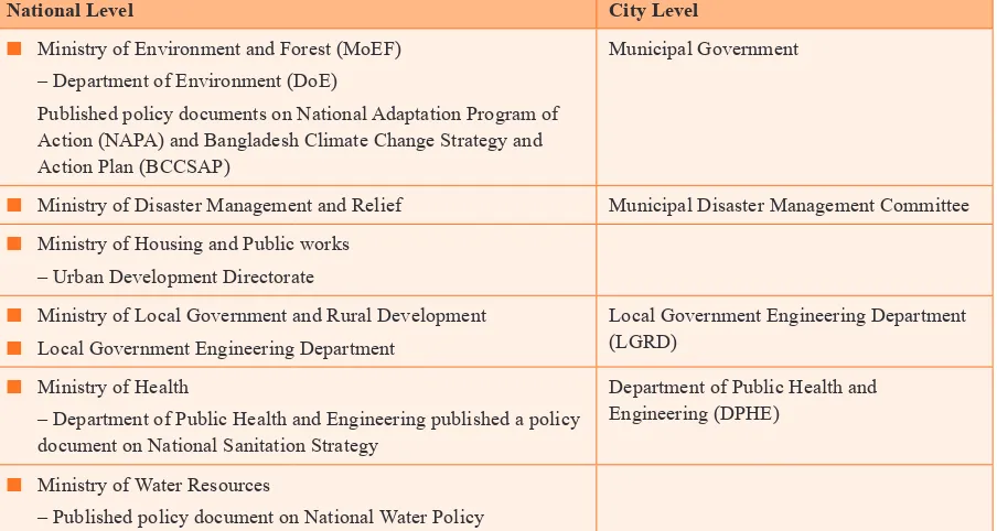
Analysis of institutional weakness is vital to cope with climate change impacts because climatic hazards are linked to structural vulnerability (Revi, 2008; Karanth and Archer, 2014). In Bangladesh, there are several organisations and policies responsible for climate change adaptation at the national and city levels. The key institutions and the policies are presented in Table 2.
The Ministry of the Environment and Forest (MoEF) and the Directorate of the Environment (DoE) published the national policy document on the National Adaptation Programme of Action (NAPA) of Bangladesh in 2005. The NAPA does not directly highlight urban climate change resilience issues, but under capacity building it mentions projects for enhancing climate resilience of urban infrastructure and industries. The national policy for safe drinking water and sanitation strategy issued in 1998, the national sanitation strategy issued in 2005 and the pro-poor strategy for water sanitation sector issued in 2005 do not include any consideration of climate change. But the Bangladesh Climate Change Strategy and Action Plan (BCCSAP), published by MoEF in 2009, includes provision for improved urban drainage under the infrastructure theme. National action policies and strategic plans play an important role in the planning of any development activities at the city level. Moreover, it is necessary to build capacity at the city level so that climate change impacts can be understood and the
Table 2. Stakeholders and entry points for climate
resilience planning
National Level City Level
■
■ Ministry of Environment and Forest (MoEF) – Department of Environment (DoE)
Published policy documents on National Adaptation Program of Action (NAPA) and Bangladesh Climate Change Strategy and Action Plan (BCCSAP)
Municipal Government
■
■ Ministry of Disaster Management and Relief Municipal Disaster Management Committee
■
■ Ministry of Housing and Public works – Urban Development Directorate
■
■ Ministry of Local Government and Rural Development
■
– Department of Public Health and Engineering published a policy document on National Sanitation Strategy
Department of Public Health and Engineering (DPHE)
■
■ Ministry of Water Resources
– Published policy document on National Water Policy
Source: ICCCAD ield survey 2015
6.2 Integrated approach
Increasingly, the urban climate resilience literature suggests that the presence of multi-stakeholder and multi-level collaboration is essential (Corfee-Morlot et al., 2011; Brown et al., 2012; Leck and Simon, 2013; Karanth and Archer, 2014). In a multi-level collaboration, representation from all groups of people from policymakers to community members is sought, to expedite the process of achieving resilience through planning and decision making (Revi et al,
2014). Moreover, bottom-up community-based development or adaptation activities (for example, community sanitation facilities) have to be supported through multi-level governance and extended opportunities and linked into wider city level adaptation initiatives. At the same time, appropriate institutional coordination mechanisms and capacity support are
required for planning climate adaptation activities locally (Brown et al., 2012; Karanth and Archer, 2014).
These policies and strategic action plans need to be modiied to take into consideration climate change resilience. Stakeholder KII indings and consultation workshop participants pointed out that in Noapara city there is lack of
cooperation and collaboration among relevant national government agencies and among the local government agencies and other stakeholders. Furthermore, only four organisations were found to work alongside the community people (see Table 2). Apart from this, several NGos work in the municipality.
The indings also revealed that climate change risk reduction and adaptation and mitigation related strategies and actions
A multi-stakeholder platform including representatives from all these stakeholder organisations could work together to build resilience in Noapara municipality. Noapara town can take lessons from Mymensingh city, in central Bangladesh, which has recently developed a resilient city action plan to reduce disaster risks and vulnerability. The plans were developed through a multi-stakeholder approach including national government, local government, academics, NGos, CBos and local communities. Academics conducted surveys to understand risks and vulnerabilities to disasters. The results were used by academics and urban planners to develop a land use plan and a disaster risks reduction action plan to
provide necessary infrastructure and services for the local community. Field indings were validated through stakeholder
consultation and a participatory exercise at city levels (personal communication with the city mayor).
In undertaking an integrated approach, Noapara faces the following challenges:
■
■ Noapara is a relatively new town and a signiicant area of the township is still used for agricultural purposes ■
■ The population is increasing rapidly because there are economic opportunities in the town and there is a lack of institutional arrangements for new migrants to the city
■
■ Being a new municipality, Noapara lacks suficient resources (such as human resources, funds and public land) to
undertake development projects
■
■ Several unplanned developments have already been built by local private entities, and local industries were predominantly built without any environmental impact assessment (EIA)
■
■ There is a lack of coordination and exchange of information among government agencies and private entities
■
■ The municipality, as well as local NGos, do not have programmes and plans focusing on climate change-induced hazards
Local NGos and private organisations are involved in awareness-building activities on water and sanitation and microcredit-related programmes, but most do not have any long-term strategies. They are not involved in local infrastructure development work and lack coordination with government and private institutions and organisations.
Noapara municipality is vulnerable to several climatic impacts, all of which have some impact on the water and sanitation sector of the area. Therefore, it is necessary to have an integrated approach, which will focus on every aspect
of climatic disasters relevant to the area. Disaster-speciic plans and coordination among those plans will help make
the city resilient. It should be noted here that city governments typically do not have the technical capacity, funds and necessary policy framework for undertaking an integrated approach to address climatic disasters. This means Noapara also
requires assistance from the national government or other sources in the form of technical and inancial support as well
as policy and regulatory assistance. In this regard, Mongla municipality in the Bagerhat district can serve as an example
for Noapara’s local policymakers. Mongla municipality received technical and inancial support from international
development agencies through the national government. Local leaders, especially the Mongla municipality mayor, used networking with the national government and policymakers to secure such assistance and in implementing the disaster risk reduction related action plan in the city (personal communication with the Mongla city mayor).
Comprehensive analyses of vulnerability and risks are the key points for making any urban plan. A detailed vulnerability and risk analysis is beyond the scope of this current research. However, the in-depth interviews with community people
and stakeholders led to the indings outlined above regarding the impacts of climatic hazards on their lives in informal
settlements. Moreover, the research team also went through the resilience plan of other cities of developing countries, which have built their resilience under the ACCCRN initiatives. In recommending a resilience plan for Naopora, the guidelines followed were from the ACCCRN climate resilient cities. According to the recommendation of the research team, the Noapara municipal government should play the lead role in building resilience. It is their responsibility to
group all the stakeholders under the same umbrella. After modiication of the above-mentioned policies, they can begin to
undertake project-based activities by considering long-, medium- and short-term goals. often the funds provided by the
national government are inadequate for the development and implementation of a resilient city plan, so funds from donors
and the private sector, through national government, will be needed.
The prime actions recommended for building resilience, particularly for the residents of Naopora’s informal settlements,
Management of water logging and looding
First, the hotspots where stagnant water gathers should be identiied, and the necessary steps to drain the water from those
areas should then be taken.
The existing land use map from Noapara municipality should be considered when taking any development activities or strategic action plans. The master plan of the town, which was recently developed, should be strictly enforced, but there is currently a lack of necessary central government funding support as well as a lack of human resource to enforce and implement the master plan.
According to a study which looked at mainstreaming resilience in Gorakhpur City in India, marking low-lying areas as no development zones with green land use ensures the drainage of storm water:“Mapping and demarcation of water bodies and open areas in the city is important to regulate reclamation and unauthorised change of land use” (TERI, 2012). A similar approach could be taken in Noapara by protecting certain areas from development activities so that torrential
rainwater can easily be drained out through these low-lying channels to prevent looding and water logging. To identify
these areas, a comprehensive mapping study needs to be done, either by the municipality or an expert consultant, to identify these areas and possible strategies to ensure water drainage. Likely impacts of climate change are also important
while considering strategies to reduce looding or water logging. Data available from the Bangladesh Meteorological
Department may be useful in predicting future rainfall patterns.
Master plans and development activities or actions should consider the environmental risk reduction concerns by integrated planning. There is a need to translate the urban risk reduction plan at the community level for education and effective enforcement.
Ensure adequate supply of water
The BWDB should assist the town government, Local Government Engineering Department (LGED) and Department of Public Health Engineering (DPHE) in assessing the locations where water can be extracted in order to supply water to every citizen. This will also provide essential information on ground water recharge locations of water pumps. But it is not
enough to simply ensure the supply of water; it is also necessary to ensure the quality of the water. The DPHE can play a key role here by regularly monitoring water quality and also keeping the public informed of the water quality, as it is
currently doing in Bera and Singra municipalities.
Usually Noapara’s storm water discharges directly into the river Bhirab. The participants of the stakeholder consultations explained that such direct discharge is not only creating environmental problems but also posing health hazards to those who use the river water. LGED and DPHE need to coordinate efforts to prevent the discharge of the town’s waste water into the river by treating it prior to disposal.
Local people also lack safe drinking water due to encroachment of arsenic and intrusion of salinity in the hand tube wells.
To overcome this problem, there should be an investment in suficient deep tube wells. Respondents suggested that there
should be a tube well installed every kilometre so that people can access safe drinking water easily.
Ensure adequate drainage and sewerage facilities
According to the discussion of stakeholder consultation meetings, there are no sewerage systems in the Noapara town
area, and drainage facilities are conined to the Bazar area. Moreover, sometimes people connect their sewerage line
to the drainage network, resulting in untreated waste being directly discharged into the river. In addition, sometimes people construct their housing over the drainage line, especially in the slum areas. These activities hamper the proper and timely cleaning of the drain. To improve drainage and sewerage facilities, Mongla municipal town in the Bagerhat
district recently employed several development measures to alleviate the town’s water logging and drainage overlow
large ponds to harvest and conserve rainwater to alleviate the town’s drinking water problem. Mongla town also has a
protection embankment along the Pasur and Mongla rivers to prevent tidal lood and surge inundation. To carry out these
improvements the city corporation received funding support from international development partners through national government. This has increased the town’s resilience, and is an example that Naopara could seek to follow (personal communication with the mayor of Mongla).
To overcome relevant challenges in Noapara the following steps could be taken.
First, the city needs separate sewerage and drainage systems along with sewage treatment plans to ensure the safe disposal
of waste in some speciic sites. A detailed feasibility study is required to plan the drainage and sewerage system, and then the necessary inance sources will need to be identiied. LGED, DPHE and the municipal authority in collaboration with
town planners should establish separate sewerage and drainage infrastructure.
Second, there is scope to further create awareness among the local community about safe drinking water and sewerage facilities as well as the importance of not connecting the sewerage line to the drainage network. DPHE and the city government can implement programs to raise drinking water safety awareness for community people. Besides the municipal corporation, NGos, CBos and local educational institutions may also play a role in raising community awareness.
Third, the frequency of cleaning the open drains should be increased, especially before and during monsoon to ensure the easy low of water, by municipal authority cleaners. Also the LGED in association with the municipal authority should
monitor regular wastewater or rainwater drainage status, and take necessary action to ensure functional water drainage facilities. Waste dumping facilities with good accessibility and regular collection should be built. Furthermore, awareness-building programs by municipalities, CBos and community leaders should be undertaken to raise community awareness regarding problems created by dumping in open drains.
Fourth, the ban on polythene plastic bags, which constrain the proper low of water through drainage lines, should be
strictly enforced. There is already a national law against the production and use of polythene bags in Bangladesh, but it is not actively enforced and plastic bags continue to be used. Provisions for alternative resources, such as jute bags, should also be made easily available.
Fifth, a committee should be set up that includes representatives from all the key stakeholders in Noapara such as the DPHE, LGED, municipal government, NGos and community people (as proposed by Alam et al., (2015). This committee would coordinate activities and take necessary decisions. Suggestions from community members and NGos working in
this area should be considered, to ensure city resilience, but it requires the participation of all stakeholder groups.
Siltation is another major problem of the river Bhirab which is having adverse effect on the town’s water logging problem and also on the employment sector. The labourers of the Noapara port explain their worries about siltation. In earlier times many big cargo ships used to come to the Noapara port but nowadays due to siltation only small cargos can come to the port now. In addition to this, siltation also creates severe problem in the loading and unloading of the goods. The BWDB should come forward to ensure the proper navigation of the river as siltation is affecting commercial activities and employment opportunities available.
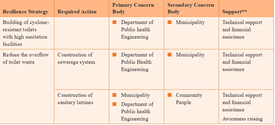
Provide sanitary latrines
The goal of the National Sanitation Strategy (GoB 2005) was to achieve 100 per cent access to sanitation by 2010. The strategy aimed to ensure access to hygienic latrines for every citizen, thus breaking the cycle of transmission of diseases. The goal could have been achieved but the infrastructure that was built was not resilient to climate change and is damaged
during looding and cyclone events. Therefore, the target of no open defecation has not been achieved practically.
Improve solid waste management
There is no speciic data about the current generation of solid waste from the municipality. But the population of the town
is increasing as migrants continue to arrive from different parts of the country, which means that the amount of solid waste
is also increasing and will continue to do so in the future. Yet there is no speciic solid waste dumping site for the city
and uncollected waste contaminates water sources. Sometimes the low-lying areas in the outskirts of the city are used as dumping sites.
Some possible management strategies include the identiication of some dumping sites, which would be demarcated and
buffered within the land use plan of the town. The planners of the municipality also should consider the potential impact of climate change while designing any dumping sites.
To manage the waste, the option of door-to-door waste collection is necessary. Residents can be encouraged to separate
their organic and inorganic waste, so that only non-degradable, non-recyclable waste goes to landill. This separation of
waste also has the potential to help produce energy or fertiliser from the organic waste should a decision be made to do so at a later date.
Awareness should also be raised among the community to prevent the dumping of waste materials in random locations within the city. Awareness-raising activity could include drama, song, billboard messages, and other events for children and adults. Awards by the municipal corporation to the best clean area leader of the municipality could also provide some social recognition for city cleaning activities.
A summary of the actions required in the water and sanitation sectors to building resilience of Noapara town as described
above is listed in Table 3 and Table 4, respectively.
Table 3. Actions to bring resilience in the water sector
Resilience Strategy Required Action
Table 4. Actions to bring resilience in the sanitation
**Technical support should be provided both by the government and academic experts. Funding support could be provided directly by the national government or international donors through the national government.
6.3 Inward migration to Noapara
Noapara already has a large number of different types of migrants including climate change-induced migrants. There are growing economic opportunities, such as jobs in local industries, as well as different transport facilities, so it is likely that rather than migrating long distances to large cities, future migrants from climate disaster-prone areas, particularly along the coast, could target Noapara.
KII respondents, who included city corporation oficers, town planners, government oficials and NGOs, all highlighted
that people come to Noapara from coastal and other climatic-affected regions of the country. Initially, these migrants came on a temporary basis to earn an income, but they then settle permanently with their families. The respondents also indicated that if basic facilities, particularly safe water and sanitation infrastructure and services, are ensured, future migration will likely increase.
Workshop participants recommended strengthening multi-stakeholder collaboration and cooperation among government agencies, city industrialists, urban planners, NGos and community representatives. Academics could conduct research to feed into sustainable city long-term plans and the city corporation should implement such plans with the involvement of all other stakeholders.
The current study indings show that every day thousands of people come to the Noapara municipality in search of work
7 Conclusion
The indings of the study underline that the Noapara municipality has a lack of basic services, particularly an adequate,
safe water supply and sanitation infrastructure, which are fundamental for making cities climate resilient. only about one per cent of the town’s population is served by the municipality’s supply line, and people mainly use hand tube wells for drinking and other purposes. But in some areas hand tube well water contains arsenic, which means some people have to travel long distances to collect safe drinking water. The poor in particular lack access to water because they do not own land nor do they have the economic capacity to buy and install a tube well. At the same time, improper water drainage systems aggravate the situation in those communities.
Low-income groups, especially those living in slum areas, lack safe sanitation facilities. This creates several
environmental problems by blocking drainage channels and polluting nearby water bodies, which eventually increases
health risks. Climatic hazards, such as intense rainfall and storm events, looding, drought, cyclones and salinity, in
conjunction with the existing water and sanitation situation, is anticipated to aggravate the existing challenges.
Noapara municipality is an important economic hub of the country because it is well connected through rivers, road and railway networks. The city has the potential to grow further with the arrival of new migrants. In order to accommodate new migrants, particularly those from climate-affected areas, the city needs to build its climate resilience. Noapara town
requires a comprehensive analysis of risks and vulnerability, and while making a resilience plan, will need policies and
institutional support. There are different ministries, departments, policies and strategies guiding the urban climate change resilience. To develop the necessary infrastructure for making a city resilient, especially in the water and sanitation sector, it is essential to consider climate change and resilience in water sanitation policies and strategies. An integrated approach and strategic plan will need to build resilience in the Noapara municipality. Public-private partnerships, including CBos at
all stages and levels, would be required to build the city’s climate resilience and to attract more climate-displaced people
to become permanent residents. Noapara is yet to become a destination choice for future climate-displaced people and no assessment has been done on how it may attract migrants. Due to lack of funding and a shortage of capable staff at the municipal corporation, the city lacks comprehensive understanding on risk and vulnerability. Accordingly, the city still needs to take action to understand how to become more resilient, and to implement policies to achieve this. It also needs
to create better facilities for employment and establish better housing with adequate water and sanitation for
climate-displaced migrants.
References
Abhaynagar Upazila. (n.d.). Noapara Municipality at a Glance (একনজরেনওয়াপাড়াপৌরসভা). Available at: http://abhaynagar. jessore.gov.bd/node/16532-এক-নজরে-নওয়াপাড়া-পৌরসভা [Accessed 09/06/2015]
ADB 2008. People’s Republic of Bangladesh: Strengthening the resilience of the water sector in Khulna to climate change. Technical Assistance Report. Asian Development Bank
ADB, 2014. Urban Climate Change Resilience a synopsis. Asian Development Bank. Available at: http://www.adb.org/
sites/default/iles/publication/149164/urban-climate-change-resilience-synopsis.pdf [Accessed 15/1/2015]
ADB. 2011. Adapting to Climate Change - Strengthening the Climate Resilience of the Water Sector Infrastructure in Khulna, Bangladesh. Asian Development Bank (ADB). Available at: http://adb.org/sites/default/iles/pub/2011/adapting-climate-change-ban.pdf [Accessed 08/02/2015]
Adri, N. 2013. Climate-induced Rural-Urban Migration in Bangladesh: Experience of Migrants in Dhaka City. Paper presented in Technical University of Munich, November 23, 2013.
Ahmed, A. U. and S, Neelormi, 2008. Climate change, loss of livelihoods and forced displacements in Bangladesh: whither facilitated international migration? Available at: http://www.csrlbd.org/resources/climatechange/%20doc_ details/47-climate-change-loss-of-livelihoods-andforced-displacements-in-bangladesh [Accessed 21 April, 2016]
Akter, T. 2011. Migration and living conditions in urban slums: implications for food security. Unnayononneshan. Available at: http://unnayan.org/reports/Migration.and.living.conditions.in.urban.slums.pdf [Accessed 15/2/2015]
Alam, S.S., Alam, J. AT M. and Rahman, S. (2015) “Urban climate resilience, water and sanitation Improving multi-stakeholder collaboration in Dhaka, Bangladesh” Asian Cities Climate Change Resilience working paper series, published by IIED September 2015.
M. A. Allison, S. R. Khan, S. L. Goodbred, and S. A. Kuehl, “Stratigraphic Evolution of the Late Holocene Ganges-Brahmaputra Lower Delta Plain,” Sedimentary Geology 155 (2003): 317–42.
Arup 2014. City Resilience Index: City Resilience Framework. ove Arup & Partners International Limited, London, United Kingdom
Baker, J. L. 2012. Climate Change, Disaster Risk, and the Urban Poor: Cities Building Resilience for a Changing World. World Bank, Washington, DC. Available at: http://ipcc-wg2.gov/njlite_download2.php?id=9885 [Accessed 08/02/2015]
BBS. 2012. Population and Housing Census 2011. Bangladesh Bureau of Statistics. Available at: http://www.bbs.gov.bd/ PageWebMenuContent.aspx?MenuKey=333 [Accessed 09-02-2015]
Brown, A., A, Dayal. and C, Rumbaitis. 2012. From practice to theory: emerging lessons from Asia for building urban climate change resilience. Environment and Urbanization 24 (2), 531–556.
Corfee-Morlot, J., I. Cochran, S. Hallegatte, and P. Teasdale. 2011. Multilevel Risk Governance and Urban Adaptation Policy. Climatic Change 104 (1): 169–197.
Da Silva, J., S, Kernaghan. and A, Luque. 2012. A systems approach to meeting the challenges of urban climate change. International Journal of Urban Sustainable Development 4(2), 125–145.