Open Geospatial Consortium
Publication Date: 2014-04-28
Approval Date: 2014-03-30
Submission Date: 2010-02-16 External identifier of this OGC® document: http://www.opengis.net/doc/ER/climate‐plugfest
Reference number of this document: 10‐002 Category: Public Engineering Report Editor: Raj Singh
OGC
®
Climate Challenge Integration
Plugfest 2009 Engineering Report
Copyright © 2014 Open Geospatial Consortium
To obtain additional rights of use, visit http://www.opengeospatial.org/legal/.
Warning
This document is not an OGC Standard. This document is an OGC Public Engineering Report created as a deliverable in an OGC Interoperability Initiative and is not an official position of the OGC membership. This document is distributed for review and comment. It is subject to change without notice and may not be referred to as an OGC Standard. Further, any OGC Engineering Report should not be referenced as required or mandatory technology in procurements.
Document type: OGC® Engineering Report Document subtype: NA
Document stage: Approved for public release
License Agreement
Permission is hereby granted by the Open Geospatial Consortium, ("Licensor"), free of charge and subject to the terms set forth below, to any person obtaining a copy of this Intellectual Property and any associated documentation, to deal in the Intellectual Property without restriction (except as set forth below), including without limitation the rights to implement, use, copy, modify, merge, publish, distribute, and/or sublicense copies of the Intellectual Property, and to permit persons to whom the Intellectual Property is furnished to do so, provided that all copyright notices on the intellectual property are retained intact and that each person to whom the Intellectual Property is furnished agrees to the terms of this Agreement.
If you modify the Intellectual Property, all copies of the modified Intellectual Property must include, in addition to the above copyright notice, a notice that the Intellectual Property includes modifications that have not been approved or adopted by LICENSOR.
THIS LICENSE IS A COPYRIGHT LICENSE ONLY, AND DOES NOT CONVEY ANY RIGHTS UNDER ANY PATENTS THAT MAY BE IN FORCE ANYWHERE IN THE WORLD.
THE INTELLECTUAL PROPERTY IS PROVIDED "AS IS", WITHOUT WARRANTY OF ANY KIND, EXPRESS OR IMPLIED, INCLUDING BUT NOT LIMITED TO THE WARRANTIES OF MERCHANTABILITY, FITNESS FOR A PARTICULAR PURPOSE, AND NONINFRINGEMENT OF THIRD PARTY RIGHTS. THE COPYRIGHT HOLDER OR HOLDERS INCLUDED IN THIS NOTICE DO NOT WARRANT THAT THE FUNCTIONS CONTAINED IN THE INTELLECTUAL PROPERTY WILL MEET YOUR REQUIREMENTS OR THAT THE OPERATION OF THE INTELLECTUAL PROPERTY WILL BE UNINTERRUPTED OR ERROR FREE. ANY USE OF THE INTELLECTUAL PROPERTY SHALL BE MADE ENTIRELY AT THE USER’S OWN RISK. IN NO EVENT SHALL THE COPYRIGHT HOLDER OR ANY CONTRIBUTOR OF INTELLECTUAL PROPERTY RIGHTS TO THE INTELLECTUAL PROPERTY BE LIABLE FOR ANY CLAIM, OR ANY DIRECT, SPECIAL, INDIRECT OR CONSEQUENTIAL DAMAGES, OR ANY DAMAGES WHATSOEVER RESULTING FROM ANY ALLEGED INFRINGEMENT OR ANY LOSS OF USE, DATA OR PROFITS, WHETHER IN AN ACTION OF CONTRACT, NEGLIGENCE OR UNDER ANY OTHER LEGAL THEORY, ARISING OUT OF OR IN CONNECTION WITH THE IMPLEMENTATION, USE, COMMERCIALIZATION OR PERFORMANCE OF THIS INTELLECTUAL PROPERTY.
This license is effective until terminated. You may terminate it at any time by destroying the Intellectual Property together with all copies in any form. The license will also terminate if you fail to comply with any term or condition of this Agreement. Except as provided in the following sentence, no such termination of this license shall require the termination of any third party end‐user sublicense to the Intellectual Property which is in force as of the date of notice of such termination. In addition, should the Intellectual Property, or the operation of the Intellectual Property, infringe, or in LICENSOR’s sole opinion be likely to infringe, any patent, copyright, trademark or other right of a third party, you agree that LICENSOR, in its sole discretion, may terminate this license without any compensation or liability to you, your licensees or any other party. You agree upon termination of any kind to destroy or cause to be destroyed the Intellectual Property together with all copies in any form, whether held by you or by any third party.
Except as contained in this notice, the name of LICENSOR or of any other holder of a copyright in all or part of the Intellectual Property shall not be used in advertising or otherwise to promote the sale, use or other dealings in this Intellectual Property without prior written authorization of LICENSOR or such copyright holder. LICENSOR is and shall at all times be the sole entity that may authorize you or any third party to use certification marks, trademarks or other special designations to indicate compliance with any LICENSOR standards or specifications.
This Agreement is governed by the laws of the Commonwealth of Massachusetts. The application to this Agreement of the United Nations Convention on Contracts for the International Sale of Goods is hereby expressly excluded. In the event any provision of this Agreement shall be deemed unenforceable, void or invalid, such provision shall be modified so as to make it valid and enforceable, and as so modified the entire Agreement shall remain in full force and effect. No decision, action or inaction by LICENSOR shall be construed to be a waiver of any rights or remedies available to it.
Contents
1
Introduction ... 4
1.1
Scope ... 4
1.2
The Open Geospatial Consortium ... 4
1.3
Document contributor contact points ... 4
1.4
Revision history ... 5
1.5
Forward ... 5
1.6
Abbreviated terms ... 5
2
Overview ... 5
2.1
Objectives of the Initiative ... 5
2.2
Plugweek Process, Activities, Procedures, and Artifacts ... 6
2.2.1
Australia BoM and CSIRO South Esk data sets ... 7
2.2.2
Collaborative Planning and Work via Teleconferences and Email ... 7
2.2.3
TIEs ... 7
2.2.4
Videos and FOSS4G 2009 Demonstrations ... 7
3
Background & Context ... 7
3.1
Scenarios ... 8
3.1.1
Australia ... 8
3.1.2
South Esk ... 9
3.2
Data Synthesis – Proposed Queries ... 10
3.3
Portable demonstration concept ... 10
4
Software Implementations ... 11
4.1
Services ... 11
4.2
Clients ... 11
5
Technology Integration Experiments (TIEs) ... 14
6
Strengths, Weaknesses, Opportunities & Threats (SWOT) Analysis ... 15
6.1
Strengths ... 15
6.2
Weaknesses ... 15
6.3
Opportunities ... 16
6.4
Threats ... 17
6.5
Demonstrations and videos ... 17
7
References ... 18
Tables
Table 1: Participating Organizations & Contacts ... 6
Table 2: Service Implementations ... 11
Table 3: Technology Integration Experiments (TIEs) ... 14
1
Introduction
1.1
Scope
This OGC Engineering Report (ER) documents findings of the CCIP 2009 Plugfest, which was conducted via the public Internet to address requirements stated in the CCIP Call for
Participation1. It addresses concept development, specifications tested, and interoperability
experiments conducted. The ER concludes with issues that arose, and provides recommendations for the refinement of OGC Specifications and the Plugfest process. Recommendations in this ER will be considered in the planning of future activities.
OGC expresses thanks to the Australian Bureau of Meteorology and to CSIRO for sponsoring CCIP 2009.
1.2
The Open Geospatial Consortium
The Open Geospatial Consortium (OGC) is an international not for profit voluntary industry consensus standards organization that provides a forum and proven processes for the collaborative development of free and publicly available interface specifications (open standards). These open standards enable easier access to and use of geospatial information and improved interoperability of geospatial technologies (across any device, platform, system, network or enterprise) to meet the needs of the global community. OGC open standards have been implemented broadly in the marketplace and are helping to foster distributed and component technology solutions that geo‐enable web, wireless, and location based services as well as broader government and business IT enterprises worldwide. To accomplish the mission of the Consortium, OGC conducts three programs:
OGC’s Specification Program facilitates formal consensus‐based committees, working groups and special interest groups that establish a forum for OGC’s industry, academic/research and user community members to collaboratively identify, prioritize and advance solutions to meet standards needs of the global community.
OGC’s Interoperability Program promotes rapid prototyping, testing and validation of emerging standards through fast paced Testbeds, experiments, pilot initiatives, Plugfests, and related feasibility studies.
OGC’s Outreach and Community Adoption Program conducts programs (training, articles in publications, workshops, conferences, etc) to promote awareness and implementation of OGC standards across the global community.
This ER was developed as part of the CCIP 2009 Plugfest initiative as an element of the OGC Interoperability Program. The initiative was based upon interest and contributions from several Sponsors and OGC Member organizations.
1.3
Document contributor contact points
All questions regarding this document should be directed to the editor.
1.4
Revision history
Date Release Editor Primary clauses
modified Description
2010‐02‐16 1,0 Raj Singh 2.1, 5, 6.4 Added STFC client in TIEs, minor edits, inputs on draft 0.8
2010‐01‐30 0.8 Raj Singh Entire document
1.5
Forward
Attention is drawn to the possibility that some of the elements of this document may be the subject of patent rights. The Open Geospatial Consortium shall not be held responsible for identifying any or all such patent rights.
Recipients of this document are requested to submit, with their comments, notification of any relevant patent claims or other intellectual property rights of which they may be aware that might be infringed by any implementation of the standard set forth in this document, and to provide supporting documentation.
1.6
Abbreviated terms
BoM Australia Bureau of Meteorology
CITE Compliance & Interoperability Test & Evaluation CRS Coordinate Reference System
CSIRO Commonwealth Scientific & Industrial Research Organization EPSG European Petroleum Survey Group
ER Engineering Report
HTTP HyperText Transfer Protocol IP OGC Interoperability Program OGC Open Geospatial Consortium OWS OGC Web Services
SRS Spatial Reference System
SWOT Strengths, Weaknesses, Opportunities, and Threats analysis TIE Technology Integration Experiment
URI Universal Resource Identifier URL Universal Resource Locator URN Universal Resource Name WCS Web Coverage Service
WCPS Web Coverage Processing Service WFS Web Feature Service
WMS Web Map Service
XML Extensible Markup Language
2
Overview
2.1
Objectives of the Initiative
standards—particularly the Web Coverage Service, and to structure FOSS4G 2009 workshops around the data and services offered by the Plugfest.
The intent of CCIP 2009 was to develop a network of online data services (WCS, WFS, SOS), online analysis services (WPS, WCPS, WMS), and a range of geospatial client applications that exercise those services. This report will show that all these goals were not met, for a host of reasons that generally point to the immaturity of service specifications and implementations with respect to the climate domain.
The Plugfest, however, can be considered a success as it advanced the maturity level of many of those implementations. Another measure of success is the wide range of software providers that came together to form a new community of interest for interoperable climate data access.
Table 1: Participating Organizations & Contacts
Name Organization
Bastian Schäffer 52 North
Albert Remke 52 North
Simon Jirka 52 North
Henning Bredel 52 North
Bruce Bannerman Australia Bureau of Meteorology (BoM)
Brad Lee CSIRO
Peter Taylor CSIRO
Andrew Terhorst CSIRO
Chris Tweedie ERDAS
Satish Sankaran ESRI
Mark Deaton ESRI
Sophia Parafina OpenGeo
Mike Pumphrey OpenGeo
Prof. Peter Baumann Jacobs University
Jinsongdi Yu Jacobs University
Dr. Christian Kiehle lat/lon
Cameron Shorter Lisasoft
Mark Leslie Lisasoft
Jody Garnett Lisasoft
Raj Singh Open Geospatial Consortium
Greg Buehler Open Geospatial Consortium
Dominic Lowe UK Science & Technology Facilities Council (STFC)
Ben Domenico US National Center for Atmospheric Research (NCAR)
2.2
Plugweek Process, Activities, Procedures, and Artifacts
The CCIP 2009 Plugfest was run as an OGC Plugfest, which is an evolving type of
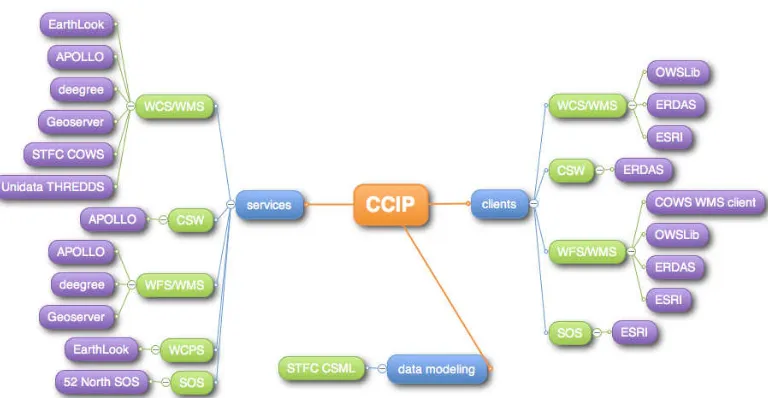
Figure 1: Target Architecture
The Plugfest was conducted over several months. These activities and the artifacts produced therein are described in the following sub‐sections.
2.2.1 Australia BoM and CSIRO South Esk data sets
The Australia BoM provided a suite of historic climate data covering all of Australia, as well as future predictions. CSIRO provided a data set of climate observations from the South Esk region of Australia.
2.2.2 Collaborative Planning and Work via Teleconferences and Email
Sponsors, OGC Staff, and Plugfest participants met online for weekly teleconferences and exchanged email daily to refine the plans for Plugfest activities, resolve data errors, announce server status, coordinate TIEs, and to identify and resolve other issues.
2.2.3 TIEs
Plugfest Participants conducted Technology Integration Experiments (TIEs) as servers became available, and resolved issues and shared results via email. Results are reported in 5 Technology Integration Experiments (TIEs).
2.2.4 Videos and FOSS4G 2009 Demonstrations
During FOSS4G 2009, OGC presented a video of the CCIP 2009 work that highlighted in detail participants’ interoperability testing. Additionally, OGC demonstrated the video in a booth at the conference, and networked with climatologists interested in furthering the work. Participants who had their own booths at the conference also presented their CCIP 2009 efforts. Following the conference, OGC developed a professionally produced video that focused on the overall climate science interoperability concept, using CCIP 2009 work to emphasize key points, and encourage future work on collaborative climate modeling.
3
Background & Context
life and property. However, climate change is changing the rules, and the past is no longer a good guide to the future. Users now require future climate data and related information – just as accessible and as easy to use as historical data – with which to assess future climate risks, and make informed decisions.
CCIP 2009 sought to take a first step towards making climate modeling more collaborative and pervasive by bringing the work of this community into the OGC services framework. Through two scenarios provided by sponsoring agencies in Australia, participants were able to work with actual source data used by climatologists, and test the ability of OGC standards to provide access and analysis services with these data.
3.1
Scenarios
3.1.1 Australia
The lead sponsor, the Australian Bureau of Meteorology, provided the primary scenario for CCIP 2009. This passage is adapted from the CCIP 2009 Wiki page at
http://external.opengis.org/twiki_public/bin/view/ClimateChallenge2009/ScenarioAusBO M.
The Australian Bureau of Meteorology archives historical observational meteorological data going back to the 1850s. These are point‐based datasets collected by the Bureau’s weather stations. In addition, the Bureau also stores more than 100 years of historical gridded rainfall and temperature data, including climatalogical (average) gridded datasets.
Secondary data, potentially affected by climate change effects such as river gauges are also archived by the Australian Bureau of Meteorology. CSIRO and the Australian Bureau of Meteorology have developed climate projections out to the year 2070 for the Australian Climate Change Science Program. These are essentially gridded (2‐dimensional array) datasets covering Australia. They encompass a range of variables, periods, percentiles, projection years and emission scenarios. The specific historical data and projection data provided for CCIP were:
Historical data
Approximately fifty years (1960 – 2007) of seasonal (winter and summer) point‐ based observations of mean temperature for selected sites – approximately 1000 observations.
Approximately fifty years of decadal (1960, 1970, 1980, 1990, 2000, 2007) seasonal (winter and summer) gridded mean temperature data.
Averages for point‐based mean temperature data.
Averages for gridded mean temperature data.
Water gauge data (1960‐2005) on a daily bases from 8 stations in the Burdekin basin.
Projection data (grid format) (WCS) Variable: Temperature change
Period: Seasonal (winter and summer)
Percentile: 50th
Projection years: 2030/2050/2070
3.1.2 South Esk
CSIRO, another sponsor, provided a secondary scenario for CCIP 2009. This passage is adapted from the CCIP 2009 Wiki page at
http://external.opengis.org/twiki_public/bin/view/ClimateChallenge2009/ServiceOffering CSIRO.
CSIRO is developing a Hydrological Sensor Web in the South Esk river catchment in Northeastern Tasmania. The South Esk is the longest river in Tasmania (214km) and has a catchment area of approximately 3350 square kilometers. Considerable climate variability within the catchment results in high spatial variability of runoff yield. The majority of the catchment rainfall‐runoff occurs in the northern and eastern headwaters. About 57% of the total water input (estimated at 3000GL/year) is either evaporated, transpired or moves into the local and regional groundwater system. The low‐lying parts of the catchment are prone to floods. Indeed Perth, a town located at the bottom of the catchment has dykes to protect it from major flood events.
Long‐term climate forecasts suggest the eastern part of the catchment will become significantly wetter, increasing flood risk. At present there is considerable growth in the forest plantations in the eastern part of the catchment. The state government is keen to develop irrigation schemes in the South Esk catchment. The changing climate and land use patterns will impact river flow and water quality. Historical river flow data will be less useful for calibrating flow models necessitating the need for adaptive, self‐calibrating models. Accurate forecast of river flow conditions is important for mitigating flood risk and irrigation planning.
The predictive skill of adaptive, self‐calibrating flow forecast models can be enhanced by exploiting additional data sources provided by the Sensor Web and through the application of near real‐time model‐data assimilation. The growth in forest plantations, apart from contributing to water loss through transpiration, will increase availability of fuel for wild fires. Extreme weather events, one of the effects of global warming, increase the risk of wild fires. Rainfall‐runoff and water quality will be affected by extensive burning of forest plantations.
The Sensor Web will provide planning authorities, water regulators, river operators, farmers and foresters enhanced situational awareness to better anticipate the effects of climate change. The Sensor Web Testbed being established in the South Esk is designed to provide three levels of situation awareness: perception (through Sensor Observation Services), comprehension (through knowledge representation and reasoning using OWL‐ based reasoners, modeling phenomena on a landscape scale) and projection
(forecasting/anticipating what will happen next). As part of this work, CSIRO has implemented:
SOS instances using 52North software.
A 1km resolution numerical weather prediction (NWP) model running over the South Esk.
Access to DEM, land use and vegetation data.
3.2
Data Synthesis – Proposed Queries
BoM proposed a series of exploratory questions that a climate scientist might seek to answer using the data provided. These helped guide the client‐server interaction experiments that were undertaken.
http://external.opengis.org/twiki_public/bin/view/ClimateChallenge2009/ScenarioAusBO M
What were the mean temperature conditions at a particular place/area and date/period?
What is the current mean temperature of a particular place or region?
How have the mean temperature characteristics varied over time?
How is it likely to vary in the future – over the seasonal (winter and summer) timescales?
What is the difference between what has happened at a particular date in the past and is likely to happen at a particular date in the future?
Which areas in the Burdekin Basin have been affected frequently by flooding since the early 1960's?
o For the above question, what are the ranges of possibilities for mean
temperature (given the various emission scenarios)?
How do present mean temperature conditions compare with past and future conditions?
Is there a spatial correlation between temperatures and water gauge levels?
What is the mean water gauge level at station x in the Burdekin Basin?
How does the mean water gauge level develop over time/area?
3.3
Portable demonstration concept
Initially, the Plugfest was designed to be easily rolled out at conferences, Testbeds and other events around the world. A great deal of energy was spent developing a strategy to deploy all the services and clients on 1‐3 computers that could be shipped to different venues. Lisasoft developed a methodology for deploying participants’ services using shared databases and a handful of virtual machines using hardware on loan from Sun
Microsystems. However, in the end we were not able to secure the hardware donation permanently, and the terms of the loan did not allow the hardware to travel to the
4
Software Implementations
4.1
Services
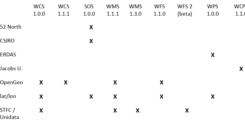
The following table shows the diversity of service implementations we had to deal with in CCIP 2009. Interoperability experiments were hampered by the lack of consistency in implementations of the various OGC service interfaces. This may be an increasing problem as OGC working groups continue to release new versions of specifications at a pace
implementers are not interested in matching. In the end, participants agreed to test WCS 1.0.0 and SOS 1.0.0, as they had the broadest support and were most useful for climate data.
Table 2: Service Implementations
WCS
1.0.0 1.1.1 WCS 1.0.0 SOS WMS 1.1.1 WMS 1.3.0 1.1.0 WFS WFS 2 (beta) 1.0.0 WPS WCPS 1.1.0
52 North X
CSIRO X
ERDAS X
Jacobs U. X
OpenGeo X X X X
lat/lon X X X X X
STFC /
Unidata X X X X
Jacobs University provided Web Coverage Processing Services (WCPS) and a client to exercise them. Jacobs University was not able to fully participate in the interoperability experiments due to the fact that no clients implemented WCPS. However, they were able to fulfill one of the project’s secondary goals, which was to gain valuable experience using climate data with OGC raster processing services.
4.2
Clients
ERDAS and ESRI provided the primary clients for technology interoperability experiments, as they were best able to interoperate with service providers. However, a number of other participants undertook work to at least be able to display their data in a variety of client software. Some of these experiments are shown here.
Figure 2: ERDAS WCS client
ESRI provided a “thick”, desktop‐based client for Web Coverage, Web Mapping, Web Features and Sensor Observation Services.
Figure 3: ESRI's WCS client
CSIRO demonstrated SOS 1.0.0 interoperating with Google Maps and NASA’s WorldWind.
Figure 4: South Esk SOS in Google Maps
Figure 5: South Esk SOS in WorldWind
Jacobs University provided a client to their own Web Coverage Processing Service version 1.1.0.
Figure 6: Jacobs University WCPS client
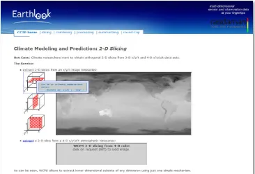
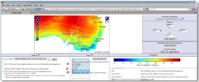
STFC provided a WMS client that displayed historical gridded data and a contour map of the projected change in temperature for a high emissions scenario.
Figure 7: STFC WMS client
5
Technology Integration Experiments (TIEs)
The table below shows all possible combinations of client‐server interactions for the two standards under formal examination. Many other standards were exercised at various stages in the initiative, including versions of WMS and WFS. However, these were mainly serving base map data. One participant deployed a Web Coverage Processing Service (WCPS), but no clients implemented that interface. Climate‐related information was
deployed via WCS and SOS. Therefore these are the only interfaces we tracked in any formal manner.
Also note that in a Plugfest, detailed results of TIEs are kept private between the implementers and are not reported here. What is public is simply the fact that certain organizations took the effort to undertake integration.
Table 3: Technology Integration Experiments (TIEs)
ERDAS
APOLLO Client
ESRI
ArcMap STFC WCS Client
SOS 1.0.0 CSIRO (52North) X
WCS 1.0.0 Geoserver X X
WCS 1.0.0 ERDAS X
WCS 1.0.0 lat/lon X
SOS 1.0.0 52North X
SOS 1.0.0 lat/lon
WCS 1.1.0 PetaScope
6
Strengths, Weaknesses, Opportunities & Threats (SWOT)
Analysis
Participants and sponsors initially developed the SWOT analysis reproduced here on the CCIP 2009 wiki. It serves as a robust, frank critique of the initiative. It should be studied keeping in mind that both the type of initiative—a Plugfest—and the domain of interest— climate science—were new areas for almost everyone involved.
6.1
Strengths
CCIP‐2009 achieved the initial objective of proving that Climate data was like any other type of spatial data and could be communicated via open standards, i.e., OGC Web Services standards.
An excellent video was produced showing the results of the work, see References: “CCIP 2009 final video.”
We have built the beginnings of a vibrant International Community.
Representatives from many countries around the world including in no specific order: Germany; UK; Canada, USA; Australia; Portugal; France.
People with skills in IT, Spatial, Policy and Open Standards.
People with a Climate science background and from Academia.
Vendors, both Proprietary and Open Source. A number of very good solutions were demonstrated.
The CCIP‐2009 email list allowed for open and frank discussions.
Vendors were able to address numerous issues in their implementation of WCS 1.0.0 and SOS 1.0.0.
Specification “version creep” was highlighted as a real issue for vendors. OGC has many standards that can be used to serve the same data sets, but they all have slightly differing capabilities.
6.2
Weaknesses
Communications channels within the community could have been substantially improved. Organization of the community and events could have been improved. An example is conference deadlines influencing the CCIP schedule.
Leadership was lacking in many cases. Being a new process and community, people hung back to see what would happen and waited for guidance.
The events at FOSS4G 2009 did not allow Participants to adequately demonstrate their work. A one‐day dedicated CCIP stream is required with at least one session being allocated to each Participant to allow them to explore their contribution in depth. This should be followed with a round table discussion on what did and didn't work as well as a planning session for the following year's event.
The burden of Leadership, Management and Planning of the event cannot be left to the OGC alone to carry. A steering committee with adequate science and industry representation needs to assist the OGC.
The event lacked Climate Science buy‐in. However, this is not a major issue, as the success of the event will allow the CCIP Project to achieve that buy‐in in 2010.
There was a lack of marketing payback for participants, though this has been overcome to a large extent after OGC donated a substantial part of their time and produced a professional video.
CCIP‐2009 was achieved with an inadequate budget.
The structure of CCIP did not allow for adequate participation by Open Source communities. This needs to be addressed for future events (see 6.4 Threats).
6.3
Opportunities
A number of potential sponsors have come forward at FOSS4G 2009.
Several influential people, including a person with marketing experience have expressed interest in becoming involved in FOSS4G 2010.
The Chair of FOSS4G 2010 has publicly declared that he would consider it an honor to have CCIP at FOSS4G 2010. He also considers CCIP 2010 a strategic event for FOSS4G 2010. There has also been interest in holding CCIP 2010 at GSDI‐12.
There was considerable interest in Professor Andy Pitman's call at FOSS4G 2009 for Climate Models to be made Open Source. Perhaps the CCIP events will be a good way to start getting the spatial and climate science communities to start working together towards this longer‐ term goal.
'Climate' is a growth industry. Governments need to make their data accessible in a free and open manner to support a wide range of climate related initiatives.
A Memorandum of Understanding has recently been signed between the OGC and the World Meteorological Organization. This should make it easier to get WMO buy‐in for CCIP 2010. There is an opportunity to get at least one Internationally recognized Climate Scientist on the Steering Committee of CCIP. We could utilize this guidance to help define a broad multi‐ year strategy for CCIP, with actual targets revised each year, based on the results of the previous year.
6.4
Threats
Some members of the Open Source spatial community were upset that the structure of the CCIP 2009 did not really allow for their participation. This is most likely due to the
perceived burden of becoming familiar with, and operating under, OGC policies and
procedures that are a requirement of participation in an Interoperability Program initiative. With the weaknesses of CCIP 2009, will there be sufficient interest to run CCIP 2010?
6.5
Demonstrations and videos
During FOSS4G 2009, OGC presented a video of the CCIP 2009 work that highlighted in detail participants’ interoperability testing. This video is listed in the References section as “CCIP 2009 video presented at FOSS4G 2009”. OGC also demonstrated the video in a booth at the conference, and networked with climatologists interested in furthering the work. Many CCIP 2009 participants had their own booths at the conference, and were able to present their CCIP 2009 efforts in greater detail, using the services installed on the virtual machines in Lisasoft’s offices (to reduce Internet latency by keeping the services on the Australian continent).
7
References
Call for Sponsors: Climate Challenge Integration Plugfest at FOSS4G 2009, http://www.opengeospatial.org/pressroom/pressreleases/1046
CCIP 2009 Call for Participation,
http://www.opengeospatial.org/pressroom/pressreleases/1072 CCIP 2009 Wiki,
http://external.opengis.org/twiki_public/bin/view/ClimateChallenge2009/ CCIP 2009 video presented at FOSS4G 2009,
http://portal.opengeospatial.org/files/?artifact_id=36086
CCIP 2009 final video, http://portal.opengeospatial.org/files/?artifact_id=36463
OGC 05‐076, OpenGIS® Web Coverage Service (WCS), Version 1.0.0 (Corrigendum), version 1.0.0
OGC 06‐083r8, OpenGIS® Web Coverage Service Implementation Specification, version 1.1.0
OGC 04‐094, OpenGIS® Web Feature Service, version 1.1 OGC 05‐007r7, OpenGIS® Web Processing Service, 1.0.0
OGC 06‐027r1, OpenGIS® Web Feature Service Implementation Specification (Corrigendum),
1.0.0
OGC 08‐091r6, Corrigendum for OpenGIS® Implementation Standard Web Processing Service,
1.0.0, 0.0.8
OGC 08‐038r5 Axis Order Policy and Recommendations