magine walking on a rocky shore. You can see the pounding surf, hear stones clink together as waves re-cede, feel the wind blowing in your hair. But the cliffs don’t move and the ground doesn’t shake. Even though the Earth appears to be a firm foundation beneath your feet, it is a dynamic planet. Continents slowly shift position;mountains rise and then erode away. These motions escape casual ob-servation because they are generally slow, although every year events such as volcanic eruptions and earthquakes re-mind us that geologic change can be rapid.
C H A P T E R
1
Geology and
the Ear th
䊳
1.1
THE SCIENCE OF GEOLOGYGeology is the study of the Earth, including the ma-terials that it is made of, the physical and chemical changes that occur on its surface and in its interior, and the history of the planet and its life forms.
THE EARTH AND ITS MATERIALS
The Earth’s radius is about 6370 kilometers, nearly one and a half times the distance from New York to Los Angeles (Fig. 1–1). If you could drive a magical vehicle from the center of the Earth to the surface at 100 kilo-meters per hour, the journey would take more than two and a half days.
Most of the Earth is composed of rocks. Rock out-crops form some of our planet’s most spectacular scenery: white chalk cliffs, pink sandstone arches, and the grey granite of Yosemite Valley. Rocks, in turn, are composed ofminerals(Fig. 1–2). Although more than 3500 differ-ent minerals exist, fewer than a dozen are common. Geologists study the origins, properties, and composi-tions of both rocks and minerals.
Geologists also explore the Earth for the resources needed in our technological world: fossil fuels such as coal, petroleum, and natural gas; mineral resources such as metals; sand and gravel; and fertilizers. Some search for water in reservoirs beneath Earth’s surface.
INTERNAL PROCESSES
Processes that originate deep in the Earth’s interior are calledinternal processes. These are the driving forces that raise mountains, cause earthquakes, and produce volcanic eruptions. Builders, engineers, and city planners might consult geologists, asking, “What is the probabil-ity that an earthquake or a volcanic eruption will dam-age our city? Is it safe to build skyscrapers, a dam, or a nuclear waste repository in the area?”
2 C H A P T E R 1 G E O L O G Y A N D T H E E A RT H
Figure 1–2 This granite rock is composed of different min-erals, primarily quartz, feldspar, and hornblende. The mineral grains are a few millimeters in diameter.
Figure 1–1 Most of the Earth is solid rock, surrounded by the hydrosphere, the biosphere, and the atmosphere.
0 10 20 30
Kilometers
BIOSPHERE All life is concentrated at or within a few kilometers of the surface
ATMOSPHERE 99% of atmosphere lies within 30 km of the surface HYDROSPHERE
Deep ocean floor 5 km deep. Fresh water and ice exist on land
Earth
SURFACE PROCESSES
Surface processesare all of those processes that sculpt the Earth’s surface. Most surface processes are driven by water, although wind, ice, and gravity are also signifi-cant. The hydrosphereincludes water in streams, wet-lands, lakes, and oceans; in the atmosphere; and frozen in glaciers. It also includes ground water present in soil and rock to a depth of at least 2 kilometers.
Most of us have seen water running over the ground during a heavy rain. The flowing water dislodges tiny grains of soil and carries them downslope. If the rain continues, the water may erode tiny gullies into a hillside (Fig. 1–3). A gully may form in a single afternoon; over much longer times, the same process forms canyons and spacious river valleys. People build cities along rivers to take advantage of the flat land, fertile soil, and abundant water. But the erosion continues. Rivers wear away at their banks and bed and periodically flood adjacent land. Geologists seek to understand these processes and advise builders and planners to minimize loss of life and property.
The oceans cover more than 70 percent of our planet. Although oceanography is a separate scientific disci-pline, it overlaps with geology. Geologic processes form the ocean basins and alter their size and shape. Weathering and erosion of continents carry mud, sand, and salts to the sea. Earth is the only planet in the Solar System that has oceans. It is also the only planet that supports life. Oceanographers examine the oceans’ in-fluence on climate, the atmosphere, life, and the solid Earth.
THE ATMOSPHERE
Theatmosphereis a mixture of gases, mostly nitrogen and oxygen (Fig. 1–4). It is held to the Earth by gravity and thins rapidly with altitude. Ninety-nine percent is concentrated within 30 kilometers of the Earth’s surface, but a few traces remain even 10,000 kilometers above the surface. A brief look at our neighbors in space reminds us that the interactions among air, rock, and life affect at-mospheric composition, temperature, and movement. The solid Earth, Venus, and Mars are approximately iden-tical in composition. Yet the three planets have radically different atmospheres and climates. Today, the Venusian atmosphere is hot, acidic, and rich in carbon dioxide. The surface temperature is 450ºC, as hot as the interior of a self-cleaning oven, and the atmospheric pressure is 90 times greater than that of the Earth. In contrast, Mars is frigid, with an atmospheric pressure only 0.006 that at the surface of the Earth. Venusian water has boiled off into space; almost all Martian water lies frozen in vast underground reservoirs.
Figure 1–3 Over long periods of time, running water can carve deep canyons, such as this tributary of Grand Canyon in the American southwest.
The Science of Geology 3
THE BIOSPHERE
Thebiosphere is the thin zone near the Earth’s surface that is inhabited by life. It includes the uppermost solid Earth, the hydrosphere, and the lower parts of the atmosphere. Land plants grow on the Earth’s surface, with roots penetrating at most a few meters into soil. Animals live on the surface, fly a kilometer or two above it, or burrow a few meters underground. Sea life also concentrates near the ocean surface, where sunlight is available. Some aquatic communities live on the deep sea floor, bacteria live in rock to depths of a few kilo-meters, and a few windblown microorganisms are found at heights of 10 kilometers or more. But even at these ex-tremes, the biosphere is a very thin layer at the Earth’s surface.
Paleontologists are geologists who study the evolu-tion and history of life by examining fossils and other evidence preserved in rock and sediment. The study of past life shows us that the solid Earth, the atmosphere, the hydrosphere, and the biosphere are all interconnected. Internal processes such as volcanic eruptions and mi-grating continents have altered the Earth’s climate and atmospheric composition. Life has altered the atmo-sphere. The atmosphere reacts with rocks.
䊳
1.2
UNIFORMITARIANISM ANDCATASTROPHISM
James Hutton was a gentleman farmer who lived in Scotland in the late 1700s. Although trained as a physi-cian, he never practiced medicine and, instead, turned to geology. Hutton observed that a certain type of rock, called sandstone, is composed of sand grains cemented together (Fig. 1–5). He also noted that rocks slowly de-compose into sand, and that streams carry sand into the lowlands. He inferred that sandstone is composed of sand grains that originated by the erosion of ancient cliffs and mountains.
Hutton tried to deduce how much time was required to form a thick bed of sandstone. He studied sand grains slowly breaking away from rock outcrops. He watched sand bouncing down streambeds. Finally he traveled to beaches and river deltas where sand was accumulating. Hutton concluded that the sequence of steps that he had observed must take a long time. He wrote that
on us who saw these phenomena for the first time, the impression will not easily be forgotten. . . . We felt ourselves necessarily carried back to the time . . . when the sandstone before us was only be-ginning to be deposited, in the shape of sand and mud, from the waters of an ancient ocean. . . . The mind seemed to grow giddy by looking so far into the abyss of time.
Hutton’s conclusions led him to formulate a princi-ple now known as uniformitarianism. The principle states that geologic change occurs over long periods of time, by a sequence of almost imperceptible events. Hutton surmised that geologic processes operating today also operated in the past. Thus, scientists can explain events that occurred in the past by observing changes oc-curring today. Sometimes this idea is summarized in the statement “ The present is the key to the past.” For ex-ample, we can observe today each individual step that leads to the formation of sandstone. Even though it would take too long for us to watch a specific layer of sand-stone form, we can infer that the processes occur slowly—step by step—over great periods of time.
If we measure current rates of geologic change, we must accept the idea that most rocks are much older than human history. Taking his reasoning one step further, Hutton deduced that our planet is very old. He was so overwhelmed by the magnitude of geological time that he wrote, “We find no vestige of a beginning, no prospect of an end.”
William Whewell, another early geologist, agreed that the Earth is very old, but he argued that geologic change was sometimes rapid. He wrote that the geologic past may have “consisted of epochs of paroxysmal and catastrophic action, interposed between periods of com-parative tranquility.” Whewell was unable to give exam-ples of such catastrophes. He argued that they happen so infrequently that none had occurred within human history.
Today, geologists know that both Hutton’s unifor-mitarianism and Whewell’s catastrophism are correct. Thus, over the great expanses of geologic time, slow, uniform processes are significant, but improbable, 4 C H A P T E R 1 G E O L O G Y A N D T H E E A RT H
catastrophic events radically modify the path of slow change.
Gradual Change in Earth History
Within the past few decades, geologists have learned that continents creep across the Earth’s surface at a rate of a few centimeters every year. Since the first steam engine was built 200 years ago, North America has migrated 8 meters westward, a distance a sprinter can run in 1 sec-ond. Thus continental motion is too slow to be observed except with sensitive instruments. However, if you could watch a time-lapse video of the past few hundred million years—only a small chunk of geologic time—you would see continents travel halfway around the Earth.
Catastrophic Change in Earth History
Chances are small that the river flowing through your city will flood this spring, but if you lived to be 100 years old, you would probably see a catastrophic flood. In fact, many residents of the Midwest saw such a flood in the summer of 1993, and California residents experi-enced one in January 1995 (Fig. 1–6).
When geologists study the 4.6 billion years of Earth history, they find abundant evidence of catastrophic events that are highly improbable in a human lifetime or even in human history. For example, giant meteorites have smashed into our planet, vaporizing enormous vol-umes of rock and spreading dense dust clouds over the sky. Similarly, huge volcanic eruptions have changed
conditions for life across the globe. Geologists have sug-gested that these catastrophic events have driven millions of species into extinction.
䊳
1.3
GEOLOGIC TIMEDuring the Middle Ages, the intellectual climate in Europe was ruled by the clergy, who tried to explain nat-ural history by a literal interpretation of the Bible. In the middle 1600s, Archbishop James Ussher calculated the Earth’s age from the Book of Genesis in the Old Testament. He concluded that the moment of creation occurred at noon on October 23, 4004 B.C.
Hutton refuted this biblical logic and deduced that the Earth was infinitely old. Today, geologists estimate that the Earth is about 4.6 billion years old. In his book Basin and Range, about the geology of western North America, John McPhee offers us a metaphor for the mag-nitude of geologic time. If the history of the Earth were represented by the old English measure of a yard, the distance from the king’s nose to the end of his out-stretched hand, all of human history could be erased by a single stroke of a file on his middle fingernail.
THE GEOLOGIC TIME SCALE
Geologists have divided Earth history into units dis-played in the geologic time scale(Table 1–1). The units are called eons, eras, periods, and epochs and are identi-Geologic Time 5
6 C H A P T E R 1 G E O L O G Y A N D T H E E A RT H
Table 1–1 • THE GEOLOGIC TIME SCALE
TIME UNITS OF THE GEOLOGIC TIME SCALE
Eon Era Period Epoch DISTINCTIVE PLANTS AND ANIMALS
Recent or Humans
58 Extinction of dinosaurs and
Paleocene many other species
66
Cretaceous First flowering plants, greatest
development of dinosaurs 144
Jurassic First birds and mammals,
abundant dinosaurs 208
Triassic First dinosaurs
245
Permian Extinction of trilobites and many
other marine animals 286
Pennsylvanian Great coal forests; abundant
insects, first reptiles
Silurian First land plant fossils
438
Ordovician First fish
505
Cambrian First organisms with shells,
trilobites dominant
3800 Approximate age of oldest rocks
Hadean
Origin of the Earth 4600⫾
Time is given in millions of years (for example, 1000 stands for 1000 million, which is one billion). The table is notdrawn to scale. We know relatively little about events that occurred during the early part of the Earth’s history. Therefore, the first four billion years are given relatively little space on this chart, while the more recent Phanerozoic Eon, which spans only 538 million years, receives proportionally more space.
fied primarily by the types of life that existed at the var-ious times. The two earliest eons, the Hadean and Archean, cover the first 2.5 billion years of Earth his-tory. Life originated during Archean time. Living organ-isms then evolved and proliferated during the Proterozoic Eon (proterois from a Greek root meaning “earlier” or “before” and zoon is from the Greek word meaning “life”). However, most Proterozoic organisms had no hard parts such as shells and bones. Most were single celled, although some multicellular organisms existed. The Proterozoic Eon ended about 538 million years ago. Then, within an astonishingly short time—perhaps as little as 5 million years—many new species evolved. These organisms were biologically more complex than their Proterozoic ancestors, and many had shells and skeletons. The most recent 13 percent of geologic time, from 538 million years ago to the present, is called the Phanerozoic Eon (phanerosis Greek for “evident”). The Phanerozoic Eon is subdivided into the Paleozoic Era (“ancient life”), the Mesozoic Era (“middle life”), and the Cenozoic Era (“recent life”) (Fig. 1–7).
䊳
1.4
THE EARTH’S ORIGINTHE EARLY SOLAR SYSTEM
No one can go back in time to view the formation of the Solar System and the Earth. Therefore, scientists will never be able to describe the sequence of events with certainty.
The hypothesis given here is based on calculations about the behavior of dust and gas in space and on observa-tions of stars and dust clouds in our galaxy. Refer to the “Focus On” box on page 12 for a discussion of how sci-entists formulate a hypothesis.
The hypothesis states that about 5 billion years ago the matter that became our Solar System was an im-mense, diffuse, frozen cloud of dust and gas rotating slowly in space. This cloud formed from matter ejected from an exploding star. More than 99 percent of the cloud consisted of hydrogen and helium, the most abun-dant elements in the Universe. The temperature of this cloud was about⫺270ºC. Small gravitational attractions among the dust and gas particles caused the cloud to condense into a sphere (Figs. 1–8a and 1–8b). As con-densation continued, the cloud rotated more rapidly, and the sphere spread into a disk, as shown in Figure 1–8c. Some scientists have suggested that a nearby star ex-ploded and the shock wave triggered the condensation.
More than 90 percent of the matter in the cloud col-lapsed toward the center of the disk under the influence of gravity, forming the protosun. Collisions among high-speed particles released heat within this early version of the Sun, but it was not a true star because it did not yet generate energy by nuclear fusion.
Heat from the protosun warmed the inner region of the disk. Then, after the gravitational collapse was nearly complete, the disk cooled. Gases in the outer part of the disk condensed to form small aggregates, much as snowflakes form when moist air cools in the Earth’s
The Earth’s Origin 7
8 C H A P T E R 1 G E O L O G Y A N D T H E E A RT H
atmosphere. Over time, the aggregates stuck together as snowflakes sometimes do. As they increased in size and developed stronger gravitational forces, they attracted additional particles. This growth continued until a num-ber of small rocky spheres, called planetesimals, formed, ranging from a few kilometers to about 100 km in di-ameter. The entire process, from the disk to the plan-etesimals, occurred quickly in geologic terms, over a pe-riod of 10,000 to 100,000 years. The planetesimals then coalesced to form a few large planets, including Earth.
At the same time that planets were forming, gravi-tational attraction pulled the gases in the protosun in-ward, creating extremely high pressure and temperature. The core became so hot that hydrogen nuclei combined to form the nucleus of the next heavier element, helium, in a process called nuclear fusion. Nuclear fusion re-leases vast amounts of energy. The onset of nuclear fu-sion marked the birth of the modern Sun, which still generates its energy by hydrogen fusion.
THE MODERN SOLAR SYSTEM
Heat from the Sun boiled most of the hydrogen, helium, and other light elements away from the inner Solar
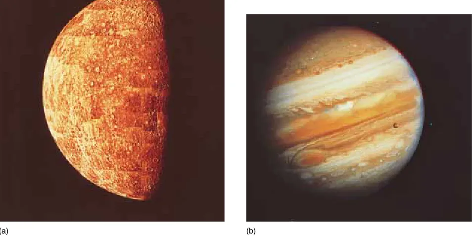
System. As a result, the four planets closest to the Sun— Mercury, Venus, Earth, and Mars—are now mainly rocky with metallic centers. These four are called the terres-trial planetsbecause they are “Earthlike.” In contrast, the four outer planets—Jupiter, Saturn, Uranus, and Neptune—are called the Jovian planets and are com-posed primarily of liquids and gases with small rocky and metallic cores (Fig. 1–9). Pluto, the outermost known planet, is anomalous. It is the smallest planet in the Solar System and is composed of rock mixed with frozen water and methane. Figure 1–10 is a schematic repre-sentation of the modern Solar System.
THE EVOLUTION OF THE MODERN EARTH
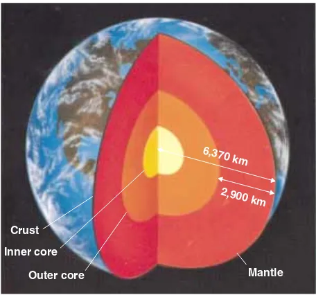
Scientists generally agree that the Earth formed by ac-cretion of small particles, as discussed above. They also agree that the modern Earth is layered. The center is a dense, hot corecomposed mainly of iron and nickel. A thickmantle, composed mainly of solid rock, surrounds the core and contains 80 percent of the Earth’s volume. Thecrustis a thin surface veneer, also composed of rock (Fig. 1–11).
(a)
(d) (e)
(b) (c)
Earth temperature and pressure increase gradually with depth. Ten meters below the surface, soil and rock are cool to the touch, but at a depth between about 100 kilometers and 350 kilometers, the mantle rock is so hot that one or two percent of it is melted, so that the entire mantle flows very slowly, like cold honey. This move-ment allows continents to move across the globe, ocean basins to open and close, mountain ranges to rise, volca-noes to erupt, and earthquakes to shake the planet. Rock is even hotter deeper in the mantle, but the intense pres-sure prevents it from melting. The outer core is
com-posed of molten metal, but the inner core, which is as hot as the surface of the Sun, is under such intense pressure that it is solid. We will discuss these layers further in Chapters 2 and 10.
Although scientists agree that our planet is layered, they disagree on how the layering developed. Astrono-mers have detected both metallic and rocky meteorites in space, and many think that both metallic and rocky particles coalesced to form the planets. According to one hypothesis, as the Earth began to form, metallic par-ticles initially accumulated to create the metallic core, Figure 1–9 (a) Mercury is a small planet close to the Sun. Consequently, most of the
lighter elements have long since been boiled off into space, and today the surface is solid and rocky. (b) Jupiter, on the other hand, is composed mainly of gases and liquids, with a small solid core. This photograph shows its turbulent atmosphere. The scales in these two photo-graphs are different. Jupiter is much larger than Mercury. (NASA)
(a) (b)
Figure 1–10 A schematic view of the Solar System. Comet
Pluto Neptune Uranus Saturn
Mars Earth Venus
Sun Mercury Jupiter
and then rocky particles collected around the core to form the rocky mantle. Thus, the Earth has always been layered.
An alternative hypothesis states that the rock and metal accumulated simultaneously during the initial co-alescence, forming a homogeneous (non-layered) planet. The young Earth became hot as gravity pulled the small particles together and later as asteroids, comets, and planetesimals crashed into the surface. At the same time, radioactive decay heated the Earth’s interior. Thus, our planet became so hot that all or most of it melted soon after it formed. Heavy molten iron and nickel gravitated toward the center and collected to form the core, while lighter materials floated toward the surface to form the mantle. In both hypotheses, the crust formed later, as dis-cussed in Chapter 12.
How can we determine which of the two hypotheses is correct? By studying modern meteorites and lunar rocks, two geologists recently estimated that the core formed at least 62 million years after the Earth coa-lesced.1This interpretation supports the hypothesis that our planet was initially homogeneous and then separated
into the core and mantle at a later date. However, as dis-cussed in “Focus On: Hypothesis, Theory, and Law,” fu-ture research may change our views about a sequence of events that occurred so long ago.
䊳
1.5
GEOLOGIC CHANGE ANDTHE ENVIRONMENT
The Earth’s surface environment has changed frequently and dramatically during its long history. Atmospheric composition and climate have changed. Glaciers have covered huge portions of the continents and then melted to leave the land covered by tropical swamps or scorch-ing deserts. Volcanic eruptions and meteorite impacts have occurred, and many scientists think that these events have caused global catastrophes that resulted in extinc-tions of large proporextinc-tions of the Earth’s species.
Primitive human-like species evolved in East Africa about 4 million years ago. Thus,homo sapiensand their immediate ancestors have lived on Earth for a mere 0.05 percent of its history. The Industrial Revolution began only 250 years ago. Yet within this minuscule slice of ge-ologic history, humans have altered the surface of the planet. Today, farms cover vast areas that were recently forested or covered by natural prairies. People have paved large expanses of land, drained wetlands, dammed rivers, pumped ground water to the surface, and released pollu-tants into waterways and the atmosphere. Some of these changes have affected even the most remote regions of the Earth, including the Sahara desert, the Amazon rain-forest, the central oceans, and the South Pole. Some scientists are concerned that these changes also threaten human well-being.
RISK ASSESSMENT AND COST–BENEFIT ANALYSIS
Many geologic processes put humans at risk. Volcanic eruptions, earthquakes, floods, and mudslides kill people and destroy cities. Human activities also create environ-mental hazards that jeopardize our health. Geologists and other geoscientists attempt to analyze the risks and costs of exposure to these hazards.
Risk assessment is the analysis of risk and the implementation of policy based on that analysis. Cost– benefit analysis compares the monetary expense of solv-ing a problem with the monetary benefits of the solution. Consider the following two examples of risk assess-ment and cost–benefit analysis.
10 C H A P T E R 1 G E O L O G Y A N D T H E E A RT H
1Der-Chuen Lee and Alex N. Halliday, “Hafnium-tungsten Chrono-metry and the Timing of Terrestrial Core Formation.”Science, vol. 378, Dec. 21/28, 1995, p. 771.
Crust Inner core
Outer core Mantle
2,900 km 6,370 km
California Earthquakes
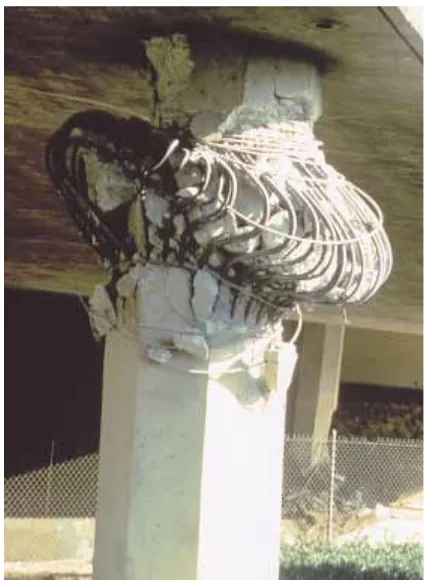
About 85 percent of the people and industry in California are located close to the San Andreas fault zone, an active earthquake zone that parallels the Pacific coast from the Mexican border to Cape Mendocino, north of San Francisco. Earthquakes occur frequently throughout this region, causing property damage and loss of life. Geologists are unable to predict exactly when and where the next quake will strike, but they can identify high-risk regions with high probabilities of a devastating earth-quake. Building codes are written accordingly.
Engineers can build structures that will withstand even the most severe earthquakes, but only at great ex-pense. As a result, building codes represent a compro-mise between safety and cost. Construction requirements for nuclear power plants are stricter than those for bridges because if a nuclear power plant were to fail, thousands of people could die, whereas only a few would die if a bridge collapsed (Fig. 1–12).
In the late 1970s, the California state government authorized the Seismic Safety Commission to recom-mend upgrading state-owned structures to meet stricter engineering criteria. The commission evaluated soil and bedrock at probable earthquake zones and then recom-mended construction upgrades based on the probable number of lives saved per dollar. This cost–benefit analy-sis assures people that the state will not raise taxes a great deal to pay for costly reconstruction. The tradeoff is that in a large earthquake, some people will die when structures collapse.
Toxic Ground Water
At many mines and industrial sites, toxic chemicals have leaked into soil. Geologists measure how fast these com-pounds spread into ground water, and they ask, “Do the chemicals threaten drinking water resources and human health?” “Can the chemicals be contained or removed?” To measure the risks associated with contaminated ground water, we must evaluate the toxicity of the pol-lutant. Because it is unethical to feed potentially toxic chemicals directly to humans, scientists may feed con-centrated doses to laboratory rats. If the rats sicken or die, the scientists infer that the chemical may be toxic to humans in lower doses. However, a substance that is poi-sonous to rats may or may not be poipoi-sonous to humans. Scientists also question whether it is valid to extrapolate results of high-dose exposure to the effects of lower doses found in contaminated ground water.
Scientists also use epidemiological studies to mea-sure the health hazard of a pollutant. For example, if the
drinking water in a city is contaminated with a pesticide and a high proportion of people in the city develop an otherwise rare disease, then the scientists may infer that the pesticide caused the disease.
Because neither laboratory nor epidemiological stud-ies can prove that low doses of a pollutant are harmful to humans, scientists are faced with a dilemma: “Should we spend money to clean up the pollutant?” Some argue that such expenditure is unnecessary until we can prove that the contaminant is harmful. Others invoke the precautionary principle, which says simply, “It is better to be safe than sorry.” Proponents of the precautionary principle argue that people commonly act on the basis of incomplete proof. For example, if a mechanic told you that your brakes were faulty and likely to fail within the next 1000 miles, you would recognize this as an opinion, not a fact. Yet would you wait for proof that the brakes would fail or replace them now?
Pollution control is expensive. Water purification adds to the cost of manufactured goods. If pollutants do Geologic Change and the Environment 11
escape, removal of the contaminant and restoration of the contaminated area may be even more costly. For ex-ample, if a pollutant has already escaped into ground wa-ter, it may be necessary to excavate thousands of cubic meters of soil, process the soil to remove the contami-nant, and then return the soil to the excavated site.
However, pollution is also expensive. If a ground water contaminant causes people to sicken, the cost to society can be measured in terms of medical bills and loss of income resulting from missed work. Many con-taminants damage structures, crops, and livestock. People in polluted areas also bear expense because tourism di-minishes and land values are reduced when people no longer want to visit or live in a contaminated area. All of these costs are called externalities.
Cost–benefit analysis balances the cost of pollution control against the cost of externalities. Some people suggest that we should minimize the total cost even though this approach accepts significant pollution. Others argue that cost–benefit analysis is flawed because it ig-nores both the quality of life and the value of human life. How, they ask, can you place a dollar value on a life that ends early, or on the annoyance of a vile odor, a persis-tent cough, polluted streams, dirty air, or industrial noise? Such annoyances damage our sense of well-being.
People do not agree on an optimal level of pollution control or an acceptable level of pollution. There are no easy answers. In this textbook we will not offer solu-tions, but we will explain the scientific principles behind difficult questions.
F
O
C
U
S
O
N
H Y P O T H E S I S , T H E O R Y , A N D L A W
O
n an afternoon field trip, you may find several different types of rocks or watch a river flow by. But you can never see the rocks or river as they ex-isted in the past or as they will exist in the future. Yet a geologist might explain to you how the rocks formed millions or even a few billion years ago and might predict how the river valley will change in the future. Scientists not only study events that they have never observed and never will observe, but they also study objects that can never be seen, touched, or felt. In this book we describe the center of the Earth 6370 kilometers beneath our feet, even though no one has ever visited it and no one ever will.Much of science is built on inferences about events and objects outside the realm of direct experi-ence. An inference is a conclusion based on thought and reason. How certain are we that a conclusion of this type is correct?
Scientists develop an understanding of the nat-ural world according to a set of guidelines known as the scientific method, which involves three basic steps: (1) observation, (2) forming a hypothesis, and (3) testing the hypothesis and developing a theory.
Observation
All modern science is based on observation. Suppose that you observed an ocean current carrying and de-positing sand. If you watched for some time, you would see that the sand accumulates slowly, layer by layer, on the beach. You might then visit Utah or Nevada and see cliffs of layered sandstone hundreds of meters high. Observations of this kind are the start-ing point of science.
Forming a Hypothesis
Simple observations are only a first step along the path to a theory. A scientist tries to organize observa-tions to recognize patterns. You might note that the sand layers deposited along the coast look just like the layers of sand in the sandstone cliffs. Perhaps you would then infer that the thick layers of sandstone had been deposited in an ancient ocean. You might further conclude that, since the ocean deposits layers of sand slowly, the thick layers of sandstone must have accu-mulated over a long time.
If you were then to travel, you would observe that thick layers of sandstone are abundant all over the world. Because thick layers of sand accumulate so slowly, you might infer that a long time must have been required for all that sandstone to form. From these observations and inferences you might form the hypothesis that the Earth is old.
A hypothesis is a tentative explanation built on strong supporting evidence. Once a scientist or group of scientists proposes a hypothesis, others test it by comparison with observations and experiments. Thus, a hypothesis is a rough draft of a theory that is tested against observable facts. If it explains some of the facts but not all of them, it must be altered, or if it cannot be changed satisfactorily, it must be discarded and a new hypothesis developed.
Testing the Hypothesis and Forming a Theory
If a hypothesis explains new observations as they accumulate and is not substantively contradicted, it
Geology is the study of the Earth including the materi-als that it is made of, the physical and chemical changes that occur on its surface and in its interior, and the his-tory of the planet and its life forms.
Most of the Earth is composed of rocks, and rocks are composed of minerals. Internal processes move continents and cause earthquakes and volcanoes; surface processes sculpt mountains and valleys. The hydro-sphere consists of water in streams, lakes, and oceans; in the atmosphere; and frozen in glaciers. It also includes ground water that soaks soil and rock to a depth of 2 or 3 kilometers.
Theatmosphereis a mixture of gases, mostly nitro-gen and oxynitro-gen. Ninety-nine percent is concentrated in
the first 30 kilometers, but a few traces remain even 10,000 kilometers above the Earth’s surface. Organisms of the biosphere, including humans, affect and are affected by Earth’s surface processes and the compositions of the hy-drosphere and atmosphere. Paleontologists study the evo-lution and history of life from its beginning to the present. The principle of uniformitarianism states that geologic change occurs over a long period of time by a sequence of almost imperceptible events. Thus, over the immense magnitude of geologic time, processes that occur too slowly or rarely to have an impact on our daily lives are important in Earth history. In contrast, cata-strophismpostulates that geologic change occurs mainly during infrequent catastrophic events. Today, geologists S U M M A R Y
becomes elevated to a theory. Theories differ widely in form and content, but all obey four fundamental criteria:
1. A theory must be based on a series of confirmed observations or experimental results.
2. A theory must explain all relevant observations or experimental results.
3. A theory must not contradict any relevant obser-vations or other scientific principles.
4. A theory must be internally consistent. Thus, it must be built in a logical manner so that the con-clusions do not contradict any of the original premises.
For example, the theory of plate tectonics states that the outer layer of the Earth is broken into a num-ber of plates that move horizontally relative to one an-other. As you will see in later chapters, this theory is supported by many observations and seems to have no major inconsistencies.
Many theories can never be absolutely proven. For example, even though scientists are just about cer-tain that their image of atomic structure is correct, no one has watched or ever will watch an individual elec-tron travel in its orbit. Therefore, our interpretation of atomic structure is called atomic theory.
However, in some instances, a theory is elevated to a scientific law. A law is a statement of how events always occur under given conditions. It is considered to be factual and correct. A law is the most certain of scientific statements. For example, the law of gravity
states that all objects are attracted to one another in direct proportion to their masses. We cannot conceive of any contradiction to this principle, and none has been observed. Hence, the principle is called a law.
Sharing Information
The final step in the scientific process is to share your observations and conclusions with other scientists and the general public. Typically, a scientist communi-cates with colleagues to discuss current research by phone, at annual meetings, or more recently, by elec-tronic communications systems such as E-mail and Internet. When the scientist feels confident in his or her conclusions, he or she publishes them in a scien-tific journal. Colleagues review the material before it is published to ensure that the author has followed the scientific method, and, if the results are of general in-terest, the scientist may publish them in popular mag-azines or in newspapers. The authors of this text have read many scientific journals and now pass the infor-mation on to you, the student.
DISCUSSION QUESTION
Obtain a copy of a news article in a weekly news magazine. Underline the facts with one color pencil and the author’s opinions with another. Did the au-thor follow the rules for the scientific method in reaching his or her conclusions?
know that both uniformitarianism and catastrophism are correct.
The 4.6-billion-year history of the Earth is divided intoeons,eras,periods, and epochs, which are based on the types of life that existed at various times.
The Solar System formed from dust and gases that rotated slowly in space. Within its center, the gases were pulled inward with enough velocity to initiate nuclear fu-sion and create the Sun. In the disk, planets formed from coalescing dust and gases. In the inner planets, most of the lighter elements escaped, but they are important com-ponents in the outer giants.
The modern Earth is made up of a dense coreof iron and nickel, a rocky mantleof lower density, and a crust of yet lower density. One hypothesis states that
both a core and mantle existed in the earliest Earth. An alternative hypothesis states that the Earth was initially homogeneous. The primordial planet was heated by en-ergy from the original gravitational coalescence, by ra-dioactive decay, and by bombardment from outer space. This heat caused all or most of the Earth to melt, and dense materials settled to the center to form the core, while less dense rock floated toward the surface to form the mantle.
Risk assessmentis the analysis of risk of geologic and human-induced hazards and the implementation of policy based on that analysis. Cost–benefit analysis compares the monetary cost of solving a problem with the monetary benefits of the solution.
1. Give a concise definition of geology.
2. Compare and contrast internal processes with surface processes.
3. List six types of reservoirs that collectively contain most of the Earth’s water.
4. What is ground water? Where in the hydrosphere is it located?
5. What two gases comprise most of the Earth’s atmo-sphere?
6. How thick is the Earth’s atmosphere?
7. Compare and contrast uniformitarianism and catas-trophism. Give an example of each type of geologic change.
8. How old is the Earth?
9. List the Earth’s major eons in order of age. List the three eras that comprise the most recent eon.
10. Very briefly outline the formation of the Universe and the Solar System.
11. How did the Sun form? How is its composition different from that of the Earth? Explain the reasons for this dif-ference.
12. Compare and contrast the properties of the terrestrial planets with those of the Jovian planets.
13. List the three major layers of the Earth. Which is the most dense, and which is the least dense?
14. Define cost–benefit analysis and risk assessment and give an example of how these policies are implemented. 14 C H A P T E R 1 G E O L O G Y A N D T H E E A RT H
1. What would the Earth be like if it a. had no atmosphere? b. had no water?
2. In what ways do organisms, including humans, change the Earth? What kinds of Earth processes are unaffected by humans and other organisms?
Discussion Questions 15
4. Explain how the theory of the evolution of the Solar System explains the following observations:
a. All the planets in the Solar System are orbiting in the same direction. b. All the planets in the Solar System except Pluto are orbiting in the same plane. c. The chemical composition of Mercury is similar to that of the Earth. d. The Sun is composed mainly of hydrogen and helium but also contains all the elements found on Earth. e. Venus has a solid surface, whereas Jupiter is mainly a mixture of gases and liquids with a small, solid core. 5. Jupiter is composed of solids such as rock, iron, and
nickel; a vast amount of liquid hydrogen; and gases such as hydrogen, helium, ammonia, and methane. From your knowledge of the formation and structure of the Earth,
which compounds do you predict would make up Jupiter’s core, mantle, and outer shell?
6. The radioactive elements that are responsible for the heating of the Earth decompose very slowly, over a pe-riod of billions of years. How would the Earth be differ-ent if these elemdiffer-ents decomposed much more rapidly— say, over a period of a few million years?
bout 1 million earthquakes shake the Earth each year; most are so weak that we do not feel them, but the strongest demolish cities and kill thousands of people. Most of us have seen televised coverage of volcanic eruptions blasting molten rock and ash into the sky, destroying villages and threatening cities. Over geologic time, mountain ranges rise and then erode away, continents migrate around the globe, and ocean basins open and close.
Before 1960, no single theory explained all of these manifestations of the active Earth. In the early 1960s, geolo-gists developed the plate tectonics theory, which pro-vides a single, unifying framework that explains earthquakes, volcanic eruptions, mountain building, moving continents, and many other geologic events. It also allows geologists to identify many geologic hazards before they affect humans.
Because plate tectonics theory is so important to modern geology, it provides a foundation for many of the following chapters of this book. We describe and explain the basic aspects of the theory in this chapter. In following chapters we use the theory to explain the active Earth.
C H A P T E R
2
Plate Tectonics:
A First Look
India collided with southern Asia to raise the Himalayas, the Earth’s highest mountain chain. (Tom Van Sant/Geosphere Project, Santa Monica Photo Science Library)
䊳
2.1
AN OVERVIEW OF PLATE TECTONICSLike most great, unifying scientific ideas, the plate tec-tonics theory is simple. Briefly, it describes the Earth’s outer layer, called the lithosphere, as a shell of hard, strong rock. This shell is broken into seven large (and several smaller) segments called tectonic plates. They are also called lithospheric plates, and the two terms are interchangeable (Fig. 2–1). The tectonic plates float on the layer below, called the asthenosphere. The sphere, like the lithosphere, is rock. But the astheno-sphere is so hot that 1 to 2 percent of it is melted. As a result, it is plastic, and weak. The lithospheric plates glide slowly over the asthenosphere like sheets of ice drifting across a pond (Fig. 2–2). Continents and ocean basins make up the upper parts of the plates. As a tec-tonic plate glides over the asthenosphere, the continents and oceans move with it.
Most of the Earth’s major geological activity occurs at plate boundaries, the zones where tectonic plates meet and interact. Neighboring plates can move relative to one another in three different ways (Fig. 2–3). At a divergent boundary, two plates move apart, or separate. At a convergent boundary, two plates move toward each other, and at a transform boundary, they slide
horizontally past each other. Table 2–1 summarizes char-acteristics and examples of each type of plate boundary. Plate interactions at these boundaries build mountain ranges and create earthquakes and volcanic eruptions.
䊳
2.2
THE EARTH’S LAYERSThe energy released by an earthquake travels through the Earth as waves. Geologists have found that earthquake waves abruptly change both speed and direction at cer-tain depths as they pass through the Earth’s interior. Chapter 10 describes how these abrupt changes reveal that the Earth is a layered planet. Figure 2– 4 and Table 2–2 describe the layers.
THE CRUST
The crust is the outermost and thinnest layer. Because the crust is relatively cool, it consists of hard, strong rock. Crust beneath the oceans differs from that of con-tinents. Oceanic crust is 5 to 10 kilometers thick and is composed mostly of a dark, dense rock called basalt. In contrast, the average thickness of continental crust is about 20 to 40 kilometers, although under mountain ranges it can be as much as 70 kilometers thick.
Divergent boundary Convergent boundary Transform boundary
Figure 2–2 Plates of lithosphere glide over the asthenosphere, carrying continents and oceans with them. As a plate moves, old lithosphere sinks into the Earth’s interior at its leading edge, and new lithosphere forms at the trail-ing edge.
The Earth’s Layers 19
Table 2–1 • CHARACTERISTICS AND EXAMPLES OF PLATE BOUNDARIES
TYPE OF TYPES OF PLATES
BOUNDARY INVOLVED TOPOGRAPHY GEOLOGIC EVENTS MODERN EXAMPLES
Divergent Ocean-ocean Mid-oceanic ridge Sea-floor spreading, Mid-Atlantic ridge shallow
earthquakes, rising magma, volcanoes
Continent-continent Rift valley Continents torn apart, East African rift earthquakes, rising
magma, volcanoes
Convergent Ocean-ocean Island arcs and ocean Subduction, deep Western Aleutians trenches earthquakes, rising
magma, volcanoes, deformation of rocks
Ocean-continent Mountains and ocean Subduction, deep Andes trenches earthquakes, rising
magma, volcanoes, deformation of rocks
Continent-continent Mountains Deep earthquakes, Himalayas deformation of
rocks
Transform Ocean-ocean Major offset of mid- Earthquakes Offset of East Pacific
oceanic ridge axis rise in South Pacific
Continent-continent Small deformed Earthquakes, San Andreas fault mountain ranges, deformation of
deformations along rocks fault
Mid-oceanic ridge Oceanic crust
Lithosphere Asthenosphere Continental crust
Trench
Mid-oceanic
ridge Volcanic
islands Trench
Mid-oceanic ridge Continental crust Mantle
Figure 2–4 The Earth is a layered planet. The insert is drawn on an expanded scale to show near-surface layering.
Oceanic crust (5 to 10 km thick)
Lithosphere
Asthenosphere (350 km)
125 km
Continental crust (20 to 70 km thick)
Asthenosphere Lithosphere Crust
Upper mantle
Lower mantle
Liquid outer core
2250 km
3470 km
1220 km
Solid inner core
0
⫺660 km
⫺2900 km
⫺5150 km
⫺6370 km 75 km
Sea level
Oceanic crust
Mid-ocean ridge
Asthenosphere
Asthenosphere
Lithosphere
Oceanic crust
Asthenosphere Lithosphere
Ocean trench
Benioff zone
earthquakes Magma Subduction
zone
(a) (b)
(c)
Figure 2–3 Three types of boundaries separate the Earth’s tectonic plates: (a) Two plates separate at a divergent bound-ary. New lithosphere forms as hot asthenosphere rises to fill the gap where the two plates spread apart. The lithosphere is relatively thin at this type of boundary. (b) Two plates converge at a convergent boundary. If one of the plates carries oceanic crust, the dense oceanic plate sinks into the mantle in a sub-duction zone. Here an oceanic plate is sinking beneath a less dense continental plate. Magma rises from the subduction zone, and a trench forms where the subducting plate sinks. The stars mark Benioff zone earthquakes that occur as the sinking plate slips past the opposite plate (described in Chapter 10). (c) At a transform plate boundary, rocks on opposite sides of the fracture slide horizontally past each other.
The Earth’s Layers 21
Table 2–2 • THE LAYERS OF THE EARTH
LAYER COMPOSITION DEPTH PROPERTIES
Crust Oceanic crust Basalt 5–10 km Cool, hard, and strong
Continental crust Granite 20–70 km Cool, hard, and strong
Lithosphere Lithosphere includes Varies; the crust and 75–125 km Cool, hard, and strong the crust and the the mantle have
uppermost portion different
Asthenosphere Entire mantle is Extends to 350 km Hot, weak, and
ultramafic rock. Its plastic, 1% or
mineralogy varies 2% melted
Remainder of upper with depth Extends from 350 to Hot, under great
mantle 660 km pressure, and
mechanically strong
Lower mantle Extends from 660 to High pressure forms
2900 km minerals different
from those of the upper mantle
Core Outer core Iron and nickel Extends from 2900 to Liquid
5150 km
Inner core Iron and nickel Extends from 5150 km Solid to the center of the
Earth
Continents are composed primarily of a light-colored, less dense rock called granite.
THE MANTLE
The mantle lies directly below the crust. It is almost 2900 kilometers thick and makes up 80 percent of the Earth’s volume. Although the chemical composition may be similar throughout the mantle, Earth temperature and pressure increase with depth. These changes cause the strength of mantle rock to vary with depth, and thus they create layering within the mantle. The upper part of the mantle consists of two layers.
The Lithosphere
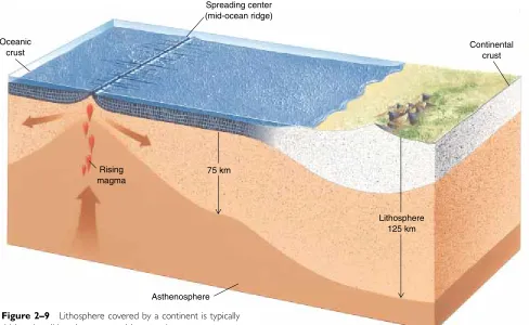
The uppermost mantle is relatively cool and consequently is hard, strong rock. In fact, its mechanical behavior is similar to that of the crust. The outer part of the Earth, including both the uppermost mantle and the crust, make up the lithosphere (Greek for “rock layer”). The litho-sphere can be as thin as 10 kilometers where tectonic plates separate. However, in most regions, the lithosphere varies from about 75 kilometers thick beneath ocean basins to about 125 kilometers under the continents. A tectonic (or lithospheric) plate is a segment of the litho-sphere.
The Asthenosphere
At a depth varying from about 75 to 125 kilometers, the strong, hard rock of the lithosphere gives way to the weak, plastic asthenosphere. This change in rock proper-ties occurs over a vertical distance of only a few kilo-meters, and results from increasing temperature with depth. Although the temperature increases gradually, it crosses a threshold at which the rock is close to its melt-ing point. As a result, 1 to 2 percent of the asthenosphere is liquid, and the asthenosphere is mechanically weak and plastic. Because it is plastic, the asthenosphere flows slowly, perhaps at a rate of a few centimeters per year. Two familiar examples of solid materials that flow are Silly Putty娃 and hot road tar. However, both of these solids flow much more rapidly than the asthenosphere rock. The asthenosphere extends from the base of the lithosphere to a depth of about 350 kilometers. At the base of the asthenosphere, increasing pressure causes the mantle to become mechanically stronger, and it remains so all the way down to the core.
THE CORE
cools to form new crust, the top layer of the lithosphere. Most of this activity occurs beneath the seas because most divergent plate boundaries lie in the ocean basins.
Both the asthenosphere and the lower lithosphere (the part beneath the crust) are parts of the mantle and thus have similar chemical compositions. The main dif-ference between the two layers is one of mechanical strength. The hot asthenosphere is weak and plastic, but the cooler lithosphere is strong and hard. As the asthenosphere rises, it cools, gains mechanical strength, and, therefore, transforms into new lithosphere. In this way, new lithosphere continuously forms at a divergent boundary.
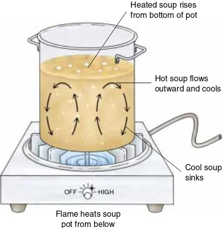
At a spreading center, the rising asthenosphere is hot, weak, and plastic. Only the upper 10 to 15 kilome-ters cools enough to gain the strength and hardness of lithosphere rock. As a result, the lithosphere, including the crust and the upper few kilometers of mantle rock, can be as little as 10 or 15 kilometers thick at a spread-ing center. But as the lithosphere spreads, it cools from the top downward. When the lithosphere cools, it be-comes thicker because the boundary between the cool, strong rock of the lithosphere and the hot, weak as-thenosphere migrates downward. Consequently, the thickness of the lithosphere increases as it moves away from the spreading center. Think of ice freezing on a pond. On a cold day, water under the ice freezes and the 22 C H A P T E R 2 P L AT E T E C TO N I C S : A F I R S T L O O K
Figure 2–5 Lithospheric plates move away from a spreading center by gliding over the weak, plastic as-thenosphere. In the center of the drawing, new litho-sphere forms at a spreading center. At the sides of the drawing, old lithosphere sinks into the mantle at sub-duction zones.
molten because of the high temperature in that region. Near its center, the core’s temperature is about 6000ºC, as hot as the Sun’s surface. The pressure is greater than 1 million times that of the Earth’s atmosphere at sea level. The extreme pressure overwhelms the temperature effect and compresses the inner core to a solid.
To visualize the relative thickness of the Earth’s lay-ers, let us return to an analogy used in Chapter 1. Imagine that you could drive a magical vehicle at 100 kilometers per hour through the Earth, from its center to its surface. You would pass through the core in about 35 hours and the mantle in 29 hours. You would drive through oceanic crust in only 6 minutes, and most continental crust in about half an hour. When you arrived at the surface, you would have spent the last 3ᎏ1
2ᎏhours traversing the entire asthenosphere and lithosphere.
䊳
2.3
PLATES AND PLATE TECTONICSIn most places, the lithosphere is less dense than the as-thenosphere. Consequently, it floats on the asthenosphere much as ice floats on water. Figure 2–1 shows that the lithosphere is broken into seven large tectonic plates and several smaller ones. Think of the plates as irregularly shaped ice floes, packed tightly together floating on the sea. Ice floes drift over the sea surface and, in a similar way, tectonic plates drift horizontally over the astheno-sphere. The plates move slowly, at rates ranging from less than 1 to about 16 centimeters per year (about as fast as a fingernail grows). Because the plates move in dif-ferent directions, they bump and grind against their neigh-bors at plate boundaries.
The great forces generated at a plate boundary build mountain ranges and cause volcanic eruptions and earth-quakes. These processes and events are called tectonic activity, from the ancient Greek word for “construction.” Tectonic activity “constructs” mountain chains and ocean basins. In contrast to plate boundaries, the interior por-tion of a plate is usually tectonically quiet because it is far from the zones where two plates interact.
DIVERGENT PLATE BOUNDARIES
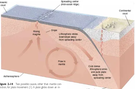
At a divergent plate boundary, also called a spreading centerand a rift zone, two lithospheric plates spread apart (Fig. 2–5). The underlying asthenosphere then oozes upward to fill the gap between the separating plates. As the asthenosphere rises between separating plates, some of it melts to form molten rock called magma.1 Most of the magma rises to the Earth’s surface, where it
1It seems counterintuitive that the rising, cooling asthenosphere
the mid-oceanic ridge system is the Earth’s longest moun-tain chain. The basaltic magma that oozes onto the sea floor at the ridge creates approximately 6.5⫻1018 (6,500,000,000,000,000,000) tons of new oceanic crust each year. The mid-oceanic ridge system and other fea-tures of the sea floor are described further in Chapter 11.
Splitting Continents: Rifting in Continental Crust
A divergent plate boundary can rip a continent in half in a process called continental rifting. A rift valley devel-ops in a continental rift zone because continental crust stretches, fractures, and sinks as it is pulled apart. Continental rifting is now taking place along a zone called the East African rift (see Fig. 2–1). If the rifting continues, eastern Africa will separate from the main portion of the continent, and a new ocean basin will open between the separating portions of Africa. The Rio Grande rift is a continental rift extending from southern Colorado to El Paso, Texas. It is unclear whether rifting is still taking place here or the process has ended.
CONVERGENT PLATE BOUNDARIES
At a convergent plate boundary, two lithospheric plates move toward each other. Convergence can occur (1) be-tween a plate carrying oceanic crust and another carrying continental crust, (2) between two plates carrying oceanic crust, and (3) between two plates carrying continental Plates and Plate Tectonics 23
ice becomes thicker. The lithosphere continues to thicken until it attains a steady state thickness of about 75 meters beneath an ocean basin, and as much as 125 kilo-meters beneath a continent.
The Mid-Oceanic Ridge: Rifting in the Oceans
A spreading center lies directly above the hot, rising as-thenosphere. The newly formed lithosphere at an oceanic spreading center is hot and therefore of low density. Consequently, the sea floor at a spreading center floats to a high elevation, forming an undersea mountain chain called the mid-oceanic ridge (Fig. 2–6). But as litho-sphere migrates away from the spreading center, it cools and becomes denser and thicker; as a result, it sinks. For this reason, the sea floor is high at the mid-oceanic ridge and lower away from the ridge. Thus, the average depth of the sea floor away from the mid-oceanic ridge is about 5 kilometers. The mid-oceanic ridge rises 2 to 3 kilome-ters above the surrounding sea floor and, thus, comes within 2 kilometers of the sea surface.
If you could place two bright red balls on the sea floor, one on each side of the ridge axis, and then watch them over millions of years, you would see the balls mi-grate away from the rift as the plates separated. The balls would also sink to greater depths as the hot rocks cooled (Fig. 2–7).
Oceanic rifts completely encircle the Earth, running around the globe like the seam on a baseball. As a result,
crust. Differences in density determine what happens where two plates converge. Think of a boat colliding with a floating log. The log is denser than the boat, so it sinks beneath the boat.
When two plates converge, the denser plate dives beneath the lighter one and sinks into the mantle. This process is called subduction. Generally, only oceanic lithosphere can sink into the mantle. Attempting to stuff 24 C H A P T E R 2 P L AT E T E C TO N I C S : A F I R S T L O O K
Mid-Oceanic ridge
Depth of sea floor(km)
0 1 2 3 4 5 6 7
Age of oceanic crust (millions of years)
0 20 40 60 80 100 120 140 160 180 200
20 40 60 80 100 120 160
180
200 140
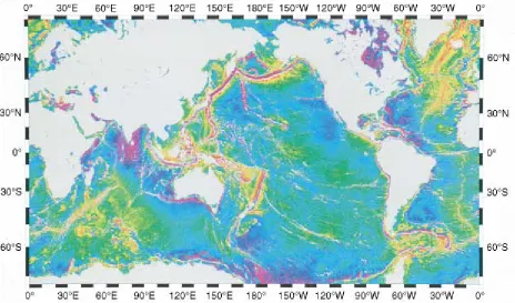
Figure 2–6 Sea floor topography is dominated by huge undersea mountain chains called mid-oceanic ridges and deep trenches called subduction zones. Mid-oceanic ridges form where tectonic plates separate, and subduction zones form where plates converge. The green areas represent the relatively level portion of the sea floor that lies about 5 kilome-ters underwater. The yellow-orange-red hues are mountains, primarily the mid-oceanic ridges. The blue-violet-magenta areas are trenches. (Scripps Institution of Oceanography, University of California, San Diego)
a low-density continent down into the mantle would be like trying to flush a marshmallow down a toilet: It will not go because it is too light. In certain cases, however, small amounts of continental crust may sink into the mantle at a subduction zone. These cases are discussed in Chapter 12.
Asubduction zone is a long, narrow belt where a lithospheric plate is sinking into the mantle. On a world-wide scale, the rate at which old lithosphere sinks into the mantle at subduction zones is equal to the rate at which new lithosphere forms at spreading centers. In this way, global balance is maintained between the creation of new lithosphere and the destruction of old lithosphere.
The oldest sea-floor rocks on Earth are only about 200 million years old because oceanic crust continuously recycles into the mantle at subduction zones. Rocks as old as 3.96 billion years are found on continents because subduction consumes little continental crust.
Convergence of Oceanic Crust with Continental Crust
When an oceanic plate converges with a continental plate, the denser oceanic plate sinks into the mantle beneath the edge of the continent. As a result, many subduction zones are located at continental margins. Today, oceanic plates are sinking beneath the western edge of South America; along the coasts of Oregon, Washington, and British Columbia; and at several other continental mar-gins (see Fig. 2–1). We will return to this subject in Chapters 11 and 12.
Convergence of Two Plates Carrying Oceanic Crust
Recall that newly formed oceanic lithosphere is hot, thin, and light, but as it spreads away from the mid-oceanic ridge, it becomes older, cooler, thicker, and denser. Thus,
the density of oceanic lithosphere increases with its age. When two oceanic plates converge, the denser one sinks into the mantle. Oceanic subduction zones are common in the southwestern Pacific Ocean and are discussed in Chapter 11.
Convergence of Two Plates Carrying Continents
If two converging plates carry continents, neither can sink into the mantle because of their low densities. In this case, the two continents collide and crumple against each other, forming a huge mountain chain. The Himalayas, the Alps, and the Appalachians all formed as results of continental collisions (Fig. 2–8). These processes are discussed in Chapter 12.
TRANSFORM PLATE BOUNDARIES
A transform plate boundary forms where two plates slide horizontally past one another as they move in opposite directions (Fig. 2–3C). California’s San Andreas fault is the transform boundary between the North American plate and the Pacific plate. This type of boundary can oc-cur in both oceans and continents and is discussed in Chapters 10, 11, and 12.
䊳
2.4
THE ANATOMY OF ATECTONIC PLATE
The nature of a tectonic plate can be summarized as follows:
1. A plate is a segment of the lithosphere; thus, it in-cludes the uppermost mantle and all of the overlying crust.
2. A single plate can carry both oceanic and continental crust. The average thickness of lithosphere covered by oceanic crust is 75 kilometers, whereas that of lithosphere covered by a continent is 125 kilometers (Fig. 2–9). Lithosphere may be as little as 10 to 15 kilometers thick at an oceanic spreading center. 3. A plate is composed of hard, mechanically strong
rock.
4. A plate floats on the underlying hot, plastic as-thenosphere and glides horizontally over it.
5. A plate behaves like a large slab of ice floating on a pond. It may flex slightly, as thin ice does when a skater goes by, allowing minor vertical movements. In general, however, each plate moves as a large, in-tact sheet of rock.
6. A plate margin is tectonically active. Earthquakes and volcanoes are common at plate boundaries. In contrast, the interior of a lithospheric plate is nor-mally tectonically stable.
The Anatomy of a Tectonic Plate 25
7. Tectonic plates move at rates that vary from less than 1 to 16 centimeters per year.
䊳
2.5
CONSEQUENCES OFMOVING PLATES
As we mentioned previously, the plate tectonics theory provides a unifying explanation for earthquakes, volca-noes, mountain building, moving continents, and many other manifestations of the Earth’s dynamic nature. In this section, we introduce some of these consequences of plate tectonics processes.
VOLCANOES
A volcanic eruption occurs where hot magma rises to the Earth’s surface. Volcanic eruptions are common at both divergent and convergent plate boundaries. Three factors can melt rock to form magma and cause volcanic erup-tions. The most obvious is rising temperature. However, hot rocks also melt to form magma if pressure decreases or if water is added to them. These magma-forming processes are discussed further in Chapter 4.
At a divergent boundary, hot asthenosphere rises to fill the gap left between the two separating plates (Fig. 2–7). Pressure decreases as the asthenosphere rises. As a result, portions of the asthenosphere melt to form huge quantities of basaltic magma, which erupts onto the Earth’s surface. The mid-oceanic ridge is a submarine chain of volcanoes and lava flows formed at a divergent plate boundary. Volcanoes are also common in continental rifts, including the East African rift and the Rio Grande rift.
At a convergent plate boundary, cold, dense oceanic lithosphere dives into the asthenosphere. The sinking plate carries water-soaked mud and rock that once lay on the sea floor. As the sinking plate descends into the man-tle, it becomes hotter. The heat drives off the water, which rises into the hot asthenosphere beneath the op-posite plate. The water melts asthenosphere rock to form huge amounts of magma in a subduction zone. The magma then rises through the overlying lithosphere. Some solidifies within the crust, and some erupts from volcanoes on the Earth’s surface. Volcanoes of this type are common in the Cascade Range of Oregon, Washington, and British Columbia; in western South America; and near most other subduction zones (Fig. 2–10).
26 C H A P T E R 2 P L AT E T E C TO N I C S : A F I R S T L O O K
Oceanic crust
Spreading center (mid-ocean ridge)
Rising magma
Asthenosphere 75 km
Lithosphere 125 km
Continental crust