THE GEOMETRIC ACCURACY VALIDATION
OF THE ZY-3 MAPPING SATELLITE
Xiaoming Gaoa, *, Xinming Tang a, Guo Zhang a,b, Xiaoyong Zhua a
Satellite Surveying and Mapping Application Center of National Administration of Surveying, Mapping and Geoinformation, No.28, Lian Hua Chi West Road, Beijing, China-(gaoxm, txm, zg,zhuxy)@sasmac.cn b State Key Laboratory of Information Engineering in Surveying, Mapping and Remote Sensing, Wuhan university,
Luo-jia-shan, Wuhan, China-guozhang @whu.edu.cn
KEY WORDS: ZY-3, Mapping Satellite, Geometric Accuracy Validation, Rigorous Geometry Model, RFM
ABSTRACT:
ZiYuan-3 (ZY-3) mapping satellite is the first civilian high-resolution stereo mapping satellite of China. The satellite’s objective is oriented towards plotting 1:50,000 and 1:25,000 topographic maps. This article proposes ZY-3 mapping satellite Rigorous Image Geometry Model and Rational Function Model (RFM). In addition, this paper utilizes the image of the ZY-3 satellite with the region of flatlands, hills and mountains for the block adjustment experiment. Different ground control points are selected and the accuracy is validated by check points, and the some Digital Surface Model (DSM), Digital Orthophoto Map (DOM) are generated and the accuracy is also validated by check points. The experiment reveals that the planar accuracy of DOM and vertical accuracy of DSM are better than 3m and 2 m, respectively. The experiment demonstrates the effectiveness of ZY-3 mapping satellite image geometry model.
* Corresponding author. This is useful to know for communication with the appropriate person in cases with more than one author. 1. INTRODUCTION
The ZiYuan-3 (ZY-3) mapping satellite, launched on January 9, 2012 in Taiyuan Satellite Launching Center, is the first civilian high-resolution stereo mapping satellite of China. Its objective is oriented to plot 1:50,000 and 1:25,000 topographic maps. It is an optical satellite with Triple Linear-array Camera and Multispectral Camera in push-broom imaging mode.
Triple Linear-array Camera is constituted with three high-resolution panchromatic cameras working in timedelay integration mode (TDI CCD). The panchromatic cameras are, respectively, in the nadir view, forward view and backward view. The forward view and backward view cameras both have a spatial resolution of 3.5m and 52km ground swath while the nadir view camera has a spatial resolution of 2.1m and 51km ground swath. Multispectral Camera provides multi-spectral 5.8m resolution images with 51km ground swath.
ZY-3 offers more than one year service of space teledetection to a wide variety of users. The data have been widely applied in surveying and mapping, agriculture, forestry, environmental protection, disaster reduction, urban planning and other departments at present. And the application department also increase rapidly. Up to now, It has been distributed more than 35 million square kilometers to domestic institutions, academy, university and other country such as American, German and Australia.
2. ZY-3 SPECIFICATIONS
ZY-3 (see Figure 1) is being manufactured by China Academy of Space Technology and its primary user is National Administration of Surveying, Mapping and Geoinformation.
.
Figure 1. flight status of ZY-3
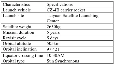
2.1 Satellite Specifications
Characteristics Specifications Launch vehicle CZ-4B carrier rocket Launch site Taiyuan Satellite Launching
Center Satellite weight 2630kg Mission duration 5 years Revisit cycle 5 days Orbital altitude 505km Orbital inclination 97.421.
Equator crossing time 10:30AM Orbital type Sun Synchronous
Table 1. Satellite Specifications
2.2 Sensor Specifications
Characteristics Triple Linear-array Camera Number of optics 3 (nadir, forward, backward) Wavelength 0.5 - 0.8μm
Ground pixel resolution
2.1m(nadir view);3.5m(forward and backward view)
Focal length 1700mm
Modulation transfer function
>0.2
Swath Width 51km(nadir view);52 km(triple stereo view)
Pixel size 7um(nadir view);10um(forward and backward view)
field angle 6 degree
Bit number 10bits
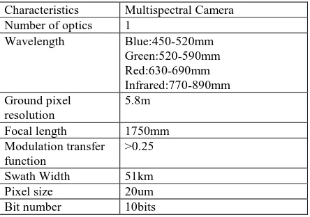
Table 2. The Specifications of Triple Linear-array Camera Characteristics Multispectral Camera
Number of optics 1
Wavelength Blue:450-520mm Green:520-590mm
Focal length 1750mm
Modulation transfer function
>0.25
Swath Width 51km
Pixel size 20um
Bit number 10bits
Table 3. The Specifications of Multispectral Camera
3. THE GEOMETRY MODEL OF ZY-3 MAPPING SATELLITE
The geometry model of images indicates the mathematical relationship between image coordinates (x, y) and ground coordinates (X,Y,Z) (Toutin 2004, Zhang 2005, Zhen and Zhang 2005, Zhu et al. 2009), involving two types. One is the rigorous image geometry model and the other is the general image geometry model, also called rational function model(RFM).
3.1 Rigorous Image Geometry Model
We constructed the rigorous image geometry model of ZY-3 calibrated images based on the gazing direction vector at the imaging moment of CCD linear array. We then established one-to-one correspondence between image point and ground point by calculating the intersection point between the CCD detector gazing direction and the earth ellipsoid model (Riazanoff 2004, Zhang 2005, Zhu et al. 2009).
As far as the raw data of ZY-3 are concerned, GPS measures the position of GPS phase centre, and attitude sensor measures the orientation from star sensor to ground in the J2000 inertial frame. In order to acquire the camera position and attitude of the main optical axis, the data measured by GPS and star sensor need to be transformed to the position and orientation of the
camera. Therefore, it is necessary to measure three offset vectors of the GPS phase centre in the satellite’s body-fixed coordinates ,the rotation matrix Rsta rb o d ybetween the star sensor and the satellite body-fixed coordinates, the boresight angle matrix body
camer a
R and the lever arm matrix
[
dx dy dz]
T between the camera frame and the satellite platform, as well as the pointing angle (X,Y) of every CCD array detector. Regardless of the atmospheric refraction effects, the rigorous image geometry model for ZY-3 calibrated image is established as follows (Xingming Tang 2013): proportional coefficient, and f is the focal length of the camera lens.
3.2 Rational Function Model
To facilitate the data processing of ZY-3, both the rigorous image geometry model and the RFM are constructed in this study.
Rational Function Model use the ratio polynomial to establish the relationship between image coordinates (x, y) and ground coordinates (X,Y,Z). In order to enhance the stability of the parameters calculation, the image coordinates and ground coordinates will be normalized to [-1,1], the ratio polynomial is established as follows:
According to the steps solving the RFM parameters (OGC 1999, Tao and Hu 2001, Zhang 2005), the RFM parameters of ZY-3 image are calculated as follows:
1. According to the image coverage, calculate the maximum and minimum ellipsoid elevation of sensor corrected product using globe 1km resolution Digital Elevation Model(DEM).
2. Then, establish ground regular grid in a certain size and generate ground coordinates of control points. 3. Calculate image coordinates of control points using anti-transformation model of rigorous geometry model of sensor corrected product.
4. Calculate the Rational Function Model by least squares adjustment and then validate using the check points.
4. GEOMETRIC VALIDATION OF ZY-3
4.1 Geometric Accuracy Analysis
The paper utilizes the imagery of the ZY-3 satellite with the region of flatlands, hills and mountains for the experiment. Different ground control points are selected and the accuracy is validated by check points.
4.1.1 Uncontrolled Block adjustment:
Free block adjustment, all of control points can be seen as check points to evaluate the accuracy.
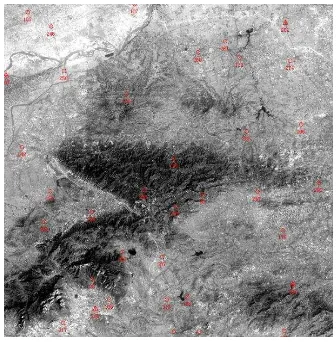
Figure 2.Control point distribution of Xianning
Figure 3.Control point distribution of Nanzhou
Figure 4.Control point distribution of Qiqihar
Orbital number
Area Plane(M) Height(M) Check points 2479 Xianning 10.020 4.250 23
351 Nanzhou 6.299 5.021 8 1749 Qiqihar 10.238 5.192 21 305,381,457 Taihang 5.62 6.59 645
381 Dengfeng 10.097 1.883 36 609 Anping 15.115 8.297 474
Table 4. Uncontrolled Block Adjustment Result 4.1.2 Controlled Block adjustment:
Using a few control points do block adjustment, others can be seen as check points to evaluate the accuracy.
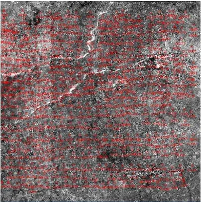
Figure 5.Control point distribution of Taihang Mountain
Figure 6.Control point distribution of Dengfeng
Figure 7.Control point distribution of Anping Orbital
number
Area Plane (M)
Height (M)
Control Check
2479 Xianning 0.571 1.219 4 19 351 Nanzhou 2.926 2.078 4 4 1749 Qiqihar 3.612 1.343 4 12 305,381,457 Taihang 2.631 2.364 11 634
381 Dengfeng 2.597 1.583 4 32 609 Anping 1.703 1.494 4 470
Table 5. Controlled Block Adjustment Result
It can see from Tables 4 and 5 that the mean square error of planar was better than 10m and the mean square error of height was better than 8m without control points. With a few control points, the mean square error of planar was better than 3m and the mean square error of height was better than 2m.
4.2 DSM and DOM product
After block adjusting the forward, backward and nadir imagery with four GCPs, the DSM was produced using dense matching techniques (Jiang 2004, Zhang and Zhang 2008, Zhang et al. 2011b) (Figure 8). An ortho-rectified image was consequently produced (Zhang 2005) (Figure 9). The remaining 470 GPS points (Anping) were used as check points to evaluate production accuracy. Vertical root mean square (RMS) error of the DSM was 2.01 m, while the planar RMS error of the ortho-image was 1.34 m.
Figure 8.DSM Product
Figure 9.DOM Product
5. CONCLUSION
It can be seen from the experiment that the planar and vertical accuracy are better than 3 meters and 2 meters respectively with a few control points, matching the criteria of 1:50,000 topographic mapping. The experiment results demonstrate the effectiveness of the ZY-3 surveying satellite imaging geometry model.
In light of the adjustment results and accuracy assessment of the DSM/DOM, ZY-3 linear-array images have reached acceptable planar and vertical geometric accuracy compared with the images of mature foreign commercial satellites of the same resolution. ZY-3, which has the broad application prospects, sets off a new era of transition from qualitative geometry to quantitative high-precision geometry for domestic satellites. Now, ZY-3 data have been widely applied in surveying and mapping, agriculture, forestry, environmental protection, disaster reduction, urban planning and other departments at present. It provides stable data source to plot 1:50,000 surveying and mapping products, update 1:25,000 even larger scale maps, and carry out mapping and change detection of land resources. In addition, the image data provide emergency
mapping services to help disaster management, ecological protection, national geographical state monitoring, etc.
ACKNOWLEDGEMENTS
The authors acknowledge Doctor Taoyang Wang and Miss Jingjing Wang for their hard work for the block adjustment experiment. This study was funded by Science and Technology Programme of National Administration of Surveying, Mapping and Geoinformation named ‘Optimization and demonstration of
technical indicators of optical surveying and mapping satellite’,
National Science and Technology Support Programme (No. 2011BAB01) and National Defense Science and Technology
Programme ‘Research on key technologies of data processing,
application and in-orbit testing for ZY3’.
REFERENCES
Jiang, W.S., 2004. Multiple aerial image matching and automatic building detection. Thesis (PhD). Wuhan University. OGC, 1999. The OpenGIS abstract specification, topic 7: the earth imagery case. Open Geospatial Consortium. Available from: http://www.opengeospatial.org/standards/as [Accessed 10 January 2012].
Riazanoff, S., 2004. SPOT 123-4-5 satellite geometry handbook [online]. GAEL Consultant. Available from: http://www-igm.univ-mlv.fr/ riazano/publications/GAEL-P135-DOC-001-01-04.pdf [Accessed 10 January 2012].
SASMAC, 2012. ZY-3 surveying satellite project [online]. Satellite Surveying and Mapping Application Center,
Tao, V.C. and Hu, Y., 2001. A comprehensive study of the rational function model for photogrammetric processing. Photogrammetric Engineering and Remote Sensing, 67 (12), 1347–1357.
Toutin, T., 2004. Geometric processing of remote sensing images: models, algorithms and methods.International Journal of Remote Sensing, 25 (10), 1893–1924.
Xinming Tang, et al., 2013. Triple linear-array image geometry model of ZiYuan-3 surveying satellite and its validation. International Journal of Image and Data Fusion, 4(1), 33–51. Zhang, G., 2005. Rectification for high resolution remote sensing image under lack of ground control points. Thesis (PhD). Wuhan University.
Zhang, G., et al., 2011b. Patch-based least squares image matching based on rational polynomial coefficients model. Acta Geodaetica et Cartographica Sinica, 40 (5), 592–597.
Zhang, L. and Zhang, J.X., 2008. Multi-image matching for DEM generation from satellite imagery. Science of Surveying and Mapping, 33 (S2), 35–39.
Zhen, X. and Zhang, Y., 2010. A critical review of image registration methods. International Journal of Image and Data Fusion, 1 (2), 137–158.
Zhu, X.Y., et al., 2009. Research and application of CBERS02B image geometric exterior calibration. Geography and Geo-Information Science, 25 (3), 16–18.