Publication Date: 2014-07-16 Approval Date: 2014-06-14 Posted Date: 2014-04-18 Reference number of this document: OGC 14-039 Reference URL for this document:
http://www.opengeospatial.net/doc/PER/testbed10/aviation-portrayal-notams Category: Public Engineering Report Editor(s): Thibault Dacla, Daniel Balog
OGC
®Testbed 10 Aviation Human Factor Based Portrayal of
Digital NOTAMs ER
Copyright © 2014 Open Geospatial Consortium
To obtain additional rights of use, visit http://www.opengeospatial.org/legal/.
Warning
This document is not an OGC Standard. This document is an OGC Public
Engineering Report created as a deliverable in an OGC Interoperability Initiative and is not an official position of the OGC membership. It is distributed for review and comment. It is subject to change without notice and may not be referred to as an OGC Standard. Further, any OGC Engineering Report should not be referenced
as required or mandatory technology in procurements.
Document type: OGC® Engineering Report
Document subtype: NA
Document stage: Approved for public release
License Agreement
Permission is hereby granted by the Open Geospatial Consortium, ("Licensor"), free of charge and subject to the terms set forth below, to any person obtaining a copy of this Intellectual Property and any associated documentation, to deal in the Intellectual Property without restriction (except as set forth below), including without limitation the rights to implement, use, copy, modify, merge, publish, distribute, and/or sublicense copies of the Intellectual Property, and to permit persons to whom the Intellectual Property is furnished to do so, provided that all copyright notices on the intellectual property are retained intact and that each person to whom the Intellectual Property is furnished agrees to the terms of this Agreement.
If you modify the Intellectual Property, all copies of the modified Intellectual Property must include, in addition to the above copyright notice, a notice that the Intellectual Property includes modifications that have not been approved or adopted by LICENSOR. THIS LICENSE IS A COPYRIGHT LICENSE ONLY, AND DOES NOT CONVEY ANY RIGHTS UNDER ANY PATENTS THAT MAY BE IN FORCE ANYWHERE IN THE WORLD.
THE INTELLECTUAL PROPERTY IS PROVIDED "AS IS", WITHOUT WARRANTY OF ANY KIND, EXPRESS OR IMPLIED, INCLUDING BUT NOT LIMITED TO THE WARRANTIES OF MERCHANTABILITY, FITNESS FOR A PARTICULAR PURPOSE, AND NONINFRINGEMENT OF THIRD PARTY RIGHTS. THE COPYRIGHT HOLDER OR HOLDERS INCLUDED IN THIS NOTICE DO NOT WARRANT THAT THE FUNCTIONS CONTAINED IN THE INTELLECTUAL PROPERTY WILL MEET YOUR REQUIREMENTS OR THAT THE OPERATION OF THE INTELLECTUAL PROPERTY WILL BE
UNINTERRUPTED OR ERROR FREE. ANY USE OF THE INTELLECTUAL PROPERTY SHALL BE MADE ENTIRELY AT THE USER’S OWN RISK. IN NO EVENT SHALL THE COPYRIGHT HOLDER OR ANY CONTRIBUTOR OF
INTELLECTUAL PROPERTY RIGHTS TO THE INTELLECTUAL PROPERTY BE LIABLE FOR ANY CLAIM, OR ANY DIRECT, SPECIAL, INDIRECT OR CONSEQUENTIAL DAMAGES, OR ANY DAMAGES WHATSOEVER RESULTING FROM ANY ALLEGED INFRINGEMENT OR ANY LOSS OF USE, DATA OR PROFITS, WHETHER IN AN ACTION OF CONTRACT, NEGLIGENCE OR UNDER ANY OTHER LEGAL THEORY, ARISING OUT OF OR IN CONNECTION WITH THE IMPLEMENTATION, USE, COMMERCIALIZATION OR PERFORMANCE OF THIS INTELLECTUAL PROPERTY. This license is effective until terminated. You may terminate it at any time by destroying the Intellectual Property together with all copies in any form. The license will also terminate if you fail to comply with any term or condition of this Agreement. Except as provided in the following sentence, no such termination of this license shall require the termination of any third party end-user sublicense to the Intellectual Property which is in force as of the date of notice of such termination. In addition, should the Intellectual Property, or the operation of the Intellectual Property, infringe, or in LICENSOR’s sole opinion be likely to infringe, any patent, copyright, trademark or other right of a third party, you agree that LICENSOR, in its sole discretion, may terminate this license without any compensation or liability to you, your licensees or any other party. You agree upon termination of any kind to destroy or cause to be destroyed the Intellectual Property together with all copies in any form, whether held by you or by any third party. Except as contained in this notice, the name of LICENSOR or of any other holder of a copyright in all or part of the Intellectual Property shall not be used in advertising or otherwise to promote the sale, use or other dealings in this Intellectual Property without prior written authorization of LICENSOR or such copyright holder. LICENSOR is and shall at all times be the sole entity that may authorize you or any third party to use certification marks, trademarks or other special designations to indicate compliance with any LICENSOR standards or specifications.
This Agreement is governed by the laws of the Commonwealth of Massachusetts. The application to this Agreement of the United Nations Convention on Contracts for the International Sale of Goods is hereby expressly excluded. In the event any provision of this Agreement shall be deemed unenforceable, void or invalid, such provision shall be modified so as to make it valid and enforceable, and as so modified the entire Agreement shall remain in full force and effect. No decision, action or inaction by LICENSOR shall be construed to be a waiver of any rights or remedies available to it.
Contents
Page1 Introduction ... 4
1.1 Scope ... 4
1.2 Document contributor contact points ... 4
1.3 Revision history ... 4
4 Testbed-10 Report on Aviation Human Factor Based Portrayal of Digital NOTAMs overview ... 7
5 SAE-G10 General Guidance for Flight Deck Display of Digital NOTAMs ... 8
5.1 Display of NOTAMs ... 8
5.2 Crew interaction with NOTAMs ... 11
6 Guidance for Specific NOTAMs ... 15
6.1 Runway Closure ... 15
6.1.1 Recommendation ... 15
6.1.2 Rationale ... 15
6.1.3 Portrayal proposal ... 16
6.1.4 Symbology Encoding ... 16
6.1.5 Problems encountered & proposed solutions ... 19
6.1.5.1 Usage of WellKnownName ... 19
6.1.5.2 Using a fixed pixel GraphicFill ... 20
6.2 Displaced threshold runway ... 20
6.2.1 Recommendation ... 20
6.2.2 Rationale ... 21
6.2.3 Portrayal proposal ... 21
6.2.4 Symbology Encoding ... 21
6.2.5 Problem encountered ... 26
6.2.6 Proposed solution ... 26
6.3 Runway shortened ... 27
6.3.1 Recommendation ... 27
6.3.2 Rationale ... 27
6.3.3 Portrayal proposal ... 28
6.3.4 Symbology Encoding ... 28
6.3.5 Problem encountered ... 30
6.3.6 Proposed solution ... 30
6.4 Taxiway closure ... 31
6.4.2 Rationale ... 31
6.4.3 Portrayal proposal ... 32
6.4.4 Symbology Encoding ... 32
6.4.5 Problem encountered & proposed solutions ... 35
6.5 Temporary Flight Restriction ... 35
6.5.1 Recommendation ... 35
6.5.2 Rationale ... 35
6.5.3 Portrayal proposal ... 36
6.5.4 Symbology Encoding ... 36
6.5.5 Problem encountered ... 38
6.5.6 Proposed solution ... 39
6.6 Changes to an Instrument Approach Procedure (IAP) ... 39
6.6.1 Recommendation ... 39
6.6.2 Rationale ... 39
6.6.3 Portrayal proposal ... 39
6.6.4 Symbology Encoding ... 39
7 Conclusion ... 40
Bibliography ... 41
Figures
Page Figure 1 - SAE-G10 proposal for Closed Runway gNOTAMs display ... 16Figure 2 – Luciad Aviation Client visualization of Runway Closure NOTAM using SE 1.1 ... 19
Figure 3 - Example of a 16x16 cross with some spacing ... 20
Figure 4 - SAE-G10 proposal for Displaced Threshold Runway gNOTAMs display ... 21
Figure 5 - Luciad Aviation Client visualization of Displaced Threshold Runway using SE 1.1 ... 26
Figure 6 - SAE-G10 proposals for Partially Closed Runway gNOTAMs display ... 28
Figure 7 - Luciad Aviation Client visualization of Runway Shortened NOTAM using SE 1.1 ... 30
Figure 8 - SAE-G10 proposal for Closed Taxiway gNOTAMs display ... 32
Figure 9 - Example of a 16x16 cross with an orange backdrop ... 34
Figure 10 - Luciad Aviation Client visualization of Taxiway closed ... 35
Figure 11 - SAE-G10 proposal for TFR gNOTAMs display ... 36
Figure 12 - Luciad Aviation Client portrayal of TFR NOTAM using Symbolgy Encoding 1.1 ... 38
Figure 13 - SAE-G10 proposal for IAP change gNOTAMs display ... 39
Tables
Page Table 1 - General requirements and recommendations for NOTAMs display ... 8OGC
®Testbed 10 Aviation Human Factor Based Portrayal of
Digital NOTAMs ER
Abstract
This activity is part of OGC Testbed 10. The aviation thread was focused on developing and demonstrating the use of the Aeronautical Information Exchange Model (AIXM) and the Flight Information Exchange Model (FIXM), building on the work accomplished in prior testbeds to advance the applications of OGC Web Services standards in next generation air traffic management systems to support European and US aviation modernization programs.
This document provides the result of the Testbed 10 to assess the compliance between the OGC standards and the guidelines provided by the SAE1 in their latest published document regarding portraying of NOTAMs. Specifically, the Human Based Portrayal of DNOTAM work attempts to fulfill the high level requirements identified in the OGC Testbed-10 RFQ Annex B2.
The purpose of this investigation was to analyze the recommendations of the SAE comity and to evaluate the feasibility of their application using OGC standards for portraying, namely the Symbology Encoding standard, version 1.1.
Keywords
ogcdoc, ogc document, testbed10, aviation, notams, portrayal, sld, se Background
In 2013, the SAE Aviation Committee published a pre-final version of an Aerospace Recommended Practice (ARP) tackling the representation of certain critical categories of NOTAMs in the flight deck of an aircraft. This ARP is constructed using the FAA guidelines provided by the Human Factor Design Standards (HFDS), and aims at providing guidelines for the representation of a sub set of NOTAMs that are the most safety critical, and the ones that affect the efficiency of airspaces the most.
1SAE International, formerly the Society of Automotive Engineers, is a U.S.-based, globally active professional association and standards organization for engineering professionals in various industries. Principal emphasis is placed on transport industries such as automotive, aerospace, and commercial vehicles.
The ARP is split up in two main sections. The first section provides general recommendations and requirements for display of NOTAMs on the flight deck on board. The second sections addresses the specific categories of NOTAMs mentioned above, with examples of what would be the best representation to enhance situation awareness. In this investigation, we focused our attention on the second part of the ARP, taking the NOTAM categories one by one and attempting to create SE rules to abide the recommendations of the SAE. We also have a look at Digital NOTAM 2.0 events and formulate a set of guidelines as to how they should be structured for compliance with the AIXM 5.1 temporality model and SE. Results and obstacles met are documented here.
Conclusions and findings
The NOTAM categories that have been deemed the most safety critical and affecting airspace efficiency the most are the following:
Runway Closure
Taxiway Closure
Displaced Threshold
Runway Shortened
Temporary Flight Restriction
Change of IAP (Instrument Approach Procedure)
For each of these categories, the SAE provided a visualization example to illustrate the recommendations provided. We illustrate our results with examples using the Luciad Aviation Client, to compare these to the recommendations provided by SAE-G10.
Here are our findings for each category: Runway and Taxiway closure
Displaced Threshold
The SE rule was constructed using the RunwayMarking feature in the AIXM 5.1 data model. To ensure that the correct information is conveyed by the DNOTAM, it must supply 2 pieces of information in the DNOTAM itself:
1. Any existing RunwayMarkings that are no longer visible, should be included in the DNOTAM with an empty geometry component. It is important here to include their identifier.
2. Any new RunwayMarkings must be defined with full geo-referenced geometry, a unique id, and a reference to the Runway they are on.
These steps are required to ensure that the AIXM 5.1 temporality model can correctly be used when applying Displaced Threshold NOTAM events.
Runway Shortened
The SE rule for Runway Shortened was achieved using the ManoeuvringAreaAvailabilty property of the DNOTAM. During the course of the research, we found there was no obvious way of distinguishing a Shortened Runway from a Closed Runway, based on the properties available in the AIXM 5.1 data model.
We offer two potential solutions to overcome this problem: Either we supply the closed section of the runway as a new RunwayElement, or we divide the baseline Runway into small segments.
Temporary Flight Restriction
The SE rule was created based on on the AirspaceActivation property of the DNOTAM. This style was split up into two components. The first component is a thick red outline. The other component describes a red hatched pattern. To make sure the hatched pattern appears on the inside of the airspace, we use the perpendicularOffset attribute of the LineSymbolizer.
Change of Instrument Approach Procedure
As the time of redaction of this document, IAP change is not supported by the DNOTAM standard. Tackling this has been postponed to future work.
1 Introduction
1.1 Scope
The scope of this OGC® document is to tackle the SAE-G10 recommendations and requirements for the human driven portrayal of NOTAMs and to attempt to produce SLD/SE rules to abide those requirements.
The general requirements and recommendations concerning the display of NOTAMs and the crew interaction with NOTAMs are listed in the first section of this document.
The recommendations that are specific to certain types of NOTAMs, together with the attempted SLD/SE rules creation to abide them are provided in the second part of the document.
This main part of this report, concerning the recommendations for a set of given NOTAMs does not have the objective to be exhaustive and to tackle all different types of NOTAMs. It is designed for the reader to easily connect it with the SAE-G10 document. This OGC® document is applicable to the portrayal of DNOTAMs according to the SAE-G10 recommendations.
1.2 Document contributor contact points
All questions regarding this document should be directed to the editor or the contributors:
Name Organization
Thibault Dacla ATMOSPHERE
Daniel Balog LUCIAD
1.3 Revision history
Date Release Editor Primary clauses modified
Description
31/01/2014 0.1 T.Dacla First Draft
16/03/2014 0.2 T.Dacla Final Draft
9/05/2014 0.3 Daniel Balog Additional information on some results
14/05/2014 0.4 T.Dacla Conclusion
1.4 Future work
At the time this report was produced, DNOTAMs to describe IAP change did not exist, therefore SLD/SE rules could be created to address the SAE-G10 recommendation. This will need to be further investigated when IAP change are supported by the DNOTAM standard.
1.5 Forward
Attention is drawn to the possibility that some of the elements of this document may be the subject of patent rights. The Open Geospatial Consortium shall not be held responsible for identifying any or all such patent rights.
Recipients of this document are requested to submit, with their comments, notification of any relevant patent claims or other intellectual property rights of which they may be aware that might be infringed by any implementation of the standard set forth in this document, and to provide supporting documentation.
2 References
The following documents are referenced in this document. For dated references, subsequent amendments to, or revisions of, any of these publications do not apply. For undated references, the latest edition of the normative document referred to applies. OGC 06-121r3, OGC® Web Services Common Standard
NOTE This OWS Common Standard contains a list of normative references that are also applicable to this Implementation Standard.
OGC 05-077r4, OGC® Symbology Encoding Implementation Specification
ARP6467, Human Factors Minimum Requirements and Recommendations for the Flight Deck Display of Data Linked Notices to Airmen (NOTAMs)
3 Conventions
3.1 Abbreviated terms
ARP Aerospace Recommended Practice DNOTAM digital NOTice to AirMen
GML Geography Markup Language gNOTAM graphical NOTice to AirMen IAP Instrument Approach Procedure LDA Landing Distance Available SAE Society of Automotive Engineers
SE Symbology Encoding
4 Testbed-10 Report on Aviation Human Factor Based Portrayal of Digital NOTAMs overview
At the time where this report is being written, the SAE committee is working on a document to provide human factor based requirements and recommendations for portrayal of digital NOTAMs. This document first provides general guidance for displaying NOTAMs on a cockpit display, and then tackles a certain number of specific digital NOTAMs and the rules to abide when displaying them.
The purpose of this report is to assess the feasibility of abiding the SAE-G10 recommendations and requirements using the OGC standard for Symbology Encoding. This document also aims at providing end users’ (pilots’) feedback on the relevance of those applied guidance.
The approach of this analysis is to list all requirements and recommendations from the different standards document, especially the SAE-G10 - Human Factors Minimum Requirements and Recommendations for the Flight Deck Display of Data Linked Notices to Airmen. Once they are listed, an analysis is made to evaluate the feasibility of addressing them using Symbology Encoding.
5 SAE-G10 General Guidance for Flight Deck Display of Digital NOTAMs
The following requirements and recommendations are general and do not concern any specific NOTAMs, they are given here as reference for readers and to give an idea of the perspective of the document.
The following table presents the general requirements and recommendations for display of digital NOTAMs. The ones marked with “r” are recommendations; those marked with “R” are requirements. The requirement/recommendation is formulated in the next column, and the rationale behind the requirement/recommendation is given in the third column.
The recommendations and requirements as shown in the following tables are direct quotations of the SAE-G10 ARP 6467. 3
5.1 Display of NOTAMs
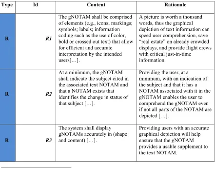
Table 1 - General requirements and recommendations for NOTAMs display
Type Id Content Rationale
R R1
The gNOTAM shall be comprised of elements (e.g., icons; markings; symbols; labels; information coding such as the use of color, bold or crossed out text) that allow for efficient and accurate
interpretation by the intended users[…].
A picture is worth a thousand words, thus the graphical
depiction of text information can speed user comprehension, save “real estate” on already crowded displays, and provide flight crews with critical just-in-time
information.
R R2
At a minimum, the gNOTAM shall indicate the subject cited in the associated text NOTAM and that a NOTAM exists that identifies the change in status of that subject […].
Providing the user, at a
minimum, with an indication of the subject and that it has a NOTAM associated with it in the gNOTAM enables the user to comprehend the gNOTAM even if not all parts of the NOTAM are depicted […].
R R3
The system shall display gNOTAMs accurately in (shape and content) […].
Providing users with an accurate graphical depiction will help ensure that the gNOTAM provides a usable supplement to the text NOTAM.
r R4
The gNOTAM should include all details from the text NOTAM. If there are too many details to display on the gNOTAM, then display the additional detail(s) that are most relevant for that NOTAM type.
Providing users with a gNOTAM that includes as many of the relevant details as possible will support users’ full
comprehension of the current status of the NOTAMs in the route of flight and should reduce the negative impact on user workload and heads down time.
R R5
NOTAM display system shall include an indication (e.g., an icon, symbol) that additional details are available for the gNOTAM, but not displayed.
Letting users know that additional NOTAM details are present but not displayed reduces the likelihood that they will miss important information.
R R6
The system shall differentiate between gNOTAMs that are currently active from those that will become active in the future (e.g., at the time of the aircraft’s scheduled arrival, within 24 hours, at some other time in the future).
Differentiating between currently active NOTAMs and those which will become active in the future will improve strategic flight planning […].
r R7
The flight deck display should, if permissible by regulation, provide an integrated depiction that shows the user’s position (e.g., route-of-flight, own-ship) relative to the gNOTAM.
Providing the users with their position relative to the gNOTAM helps the user plan and efficiently execute their planned route of flight.
r R8
If providing a gNOTAM on more than one of the same
manufacturer’s displays on the flight deck, the gNOTAM should be depicted consistently. This is particularly important if the two displays are part of installed systems. Deviations may be required to take into
consideration the advantages and limitations of the particular display and application, but users should be trained on the difference.
Users should see gNOTAMs displayed consistently across the same manufacturer’s displays on the flight deck to ensure accurate interpretation of the meaning of the gNOTAM […].
r R9 If a designer opts to superimpose
gNOTAMs over baseline data, the gNOTAM should be
superimposed over all baseline data products that contain that NOTAM’s subject and upon a baseline product on which the gNOTAM could be easily viewed […].
the gNOTAM in each and every place where they might
determine it is most useful and clear.
R R10
The system display shall show all available gNOTAMs when multiple gNOTAMs exist for a given baseline data product.
Help speed processing of information and provide a more comprehensive mental map, which may increase situation awareness.
r R11
If a single baseline data product contains multiple references to a subject, the NOTAM display system should insert the
gNOTAM in every place where that subject exists[…].
Providing users with a gNOTAM in every place where the subject appears will always provide the users with the information anytime they need it. This is preferable to having the designers try and predict this or assuming the user will not need it at a certain time in flight.
r R12
The flight deck display should follow accepted human factors standards regarding visibility, legibility, readability of display subjects to ensure that gNOTAMs are readable during flight
operations in all lighting conditions. Display subjects relevant to the flight operations environment may include
luminance contrast, font type, font size, chromaticity differences, character spacing, word spacing, line spacing, and resolution.
Users should be provided with gNOTAMs that are readable during flight operations in all lighting conditions in order to properly interpret the
information. Visibility, legibility, and readability of information in the flight deck under normal operations includes challenges such as: glare, brightness/night vision, noise, vibration, etc.
r R13
The graphical depiction of a NOTAM type should be easily identified as being different from the NOTAM categories baseline data.
Making it clear where there are differences between the baseline data and the new status of the subject will assist users in recognizing and processing that information.
r R14 The display of the gNOTAM
should accurately show the
baseline subject identified in the NOTAM (e.g., the part of the runway actually being closed) in relation to other baseline data (e.g., other airport subjects that appear on the airport diagram).
There are many ways to accomplish this including superimposing the graphical NOTAM over a baseline data product such as the airport diagram or moving map.
aeronautical information (e.g., moving map, instrument approach chart or airport diagram) rather than on an individual, separate plate, chart or diagram without any context will enable the users to
understand the information being conveyed in context with other information and not require the users to review the new
information in a new format […].
R R15
The flight deck display system shall present NOTAMs in a way that does not obscure flight relevant information that cannot per regulation be obscured and that does not permanently obscure other flight relevant information […].
Ensuring that gNOTAMs do not permanently obscure flight relevant information will enable users to remain aware of the current operational condition.
R R16
The user shall be provided with explanatory information (e.g., a legend, key) that describes the meanings of icons, symbols, colors, etc. for gNOTAMs. For example, this may take the form of an on-line user guide, external electronic help file, hard copy manual, wizard, video tutorial, or other form.
Providing users with a key or legend is critical for
comprehension of icons, symbols, colors, etc. of gNOTAMs.
5.2 Crew interaction with NOTAMs
Table 2 - Requirements and recommendations for crew interaction with NOTAMs
Type Id Content Rationale
r
When displaying multiple text-based NOTAMs, the display should be easily navigable by users. For example, make it clear when users have reached the end of a list; indicate how many NOTAMs are in the list; provide navigation buttons for moving forward or backward by page; and if the full text of the NOTAM is not displayed on the screen provide scroll bars.
R
The flight deck display shall differentiate NOTAM information from other data linked information.
Providing users with a way to differentiate between NOTAMs and other types of data linked
information will enable the users to fully utilize all information received over data link.
R
When data linked NOTAMs are available on the flight deck, text and gNOTAMs shall be available for display upon user request.
Because text and gNOTAMs are unlikely to be displayed
continuously, it is possible that the list of NOTAMs will not be visible all the time […].
r
The flight deck display should indicate when a text NOTAMs is also available in graphical form (e.g., include an icon with the text NOTAM that indicates that a graphic is available).
Providing users with an indication that a gNOTAM is available improves the users’ chances of not missing a gNOTAM which might improve understanding of the NOTAM in less time and result in a more efficient flight. It is also a critical component of ensuring that the mixed use environment does not create inaccurate assumptions by users of what gNOTAMs exist.
r
The flight deck display should provide users with immediate access to the text NOTAM from the gNOTAM.
Ensuring that users have a quick and intuitive way to access the complete text NOTAM from the gNOTAM may prevent users from missing details of the NOTAM.
r
The system should provide feedback to users regarding system status and system errors. For example, the system should communicate that it was unable to load text or gNOTAMs, that there are delays in rendering gNOTAMs, or there are
connectivity issues.
Providing users with feedback regarding system status and errors will enhance comprehension and reduce user errors […].
r
The system should provide users with the capability to manage NOTAMs.
Examples of NOTAM capabilities include display preferences (e.g., use a mix of upper and lower case letters; show NOTAMs in FAA domestic, ICAO, or plain text format; display local vs. UTC time; information coding), and
management functions such as sorting, filtering, grouping or categorizing,
A well-designed graphical user interface could enable flight crews with a means to manipulate NOTAM information so that it can be
searching, and prioritizing.
r
The system should provide a means (e.g., a menu) to clearly inform users what managing capabilities (e.g., sorting, filtering, grouping/categorizing, prioritization, translation to different formats) are available.
[…] Enable [users] to take advantage of the positive aspects for managing NOTAMs. These capabilities provide users with a way to mitigate the negative effects of volume and clutter.
r
The system should provide a means for users to select which NOTAM
capabilities they apply to their route of flight.4
Providing users with the ability to set their own preference settings before they operate their flight will provide them with the optimal use of this data. Users should also be provided with a means to change these preference settings as they see fit.
r
The system should provide information to users regarding what NOTAM
capabilities and settings have been selected.
Unfiltered NOTAMs can overload the flight crew with large volumes of unneeded, extraneous information. Filters applied by the flight crews can mitigate this situation. Providing users with the indications of what NOTAM management capabilities are being applied/displayed will allow the user to effectively manage the NOTAM information displayed.
R
The system shall provide an indication to users that changes have been made to their current NOTAM list.
Providing users with an indication that changes have been made to current NOTAMs will help them remain aware of changes that may impact their flight.
R
The system shall provide users with a time stamp indicating when the latest update to the NOTAM information was received.
Providing users with an indication when the latest NOTAM information was received will provide the users with an indication of the temporality of the information displayed.
R
The developer shall provide the user with current documentation to reference the subjects (e.g., components, functions, common tasks, disclaimers) of the system
Users must be provided with an official current document in order to fully understand how to use the system in case questions or
that displays NOTAMs. performance issues arise.
r
Users should be provided with training that explains both the capabilities of the NOTAM display system and how to use it.
6 Guidance for Specific NOTAMs
Along with the general guidance for displaying graphical NOTAMs, the SAE-G10 document provides a set of recommendations for displaying specific types of NOTAMs. The specific NOTAMs addressed by the SAE comity are listed below:
Runway closure,
Displaced threshold runway (for landing),
Runway shortened,
Taxiway closure,
TFR,
Changes to an instrument approach procedure (IAP).
The NOTAMs categories selected have been selected by the SAE Comity by researching which NOTAM categories resulted in the most frequent accidents and incidents.
For those specific NOTAM, a deeper analysis will be performed to evaluate the feasibility of translating the associated recommendations into Symbology Encoding rules. For each NOTAM, the following items are presented: Content of the recommendation, Rationale behind the recommendation5, Portrayal proposed by SAE, Translation of recommendation into Symbology Encoding rule, issues encountered and proposed solution.
6.1 Runway Closure
6.1.1 Recommendation
The gNOTAM of a closed runway should indicate that the entire runway is closed, ensuring that users will be able to see that the runway is closed regardless of the scale of the display. One way to accomplish this is to superimpose X’s over the entire length of the closed runway rather than just at the end of the runway.
6.1.2 Rationale
If users can recognize that an entire runway is closed based upon the graphical
depiction, then they are less likely to miss the closed runway even if they are viewing the runway on a scale that only shows part of the runway.
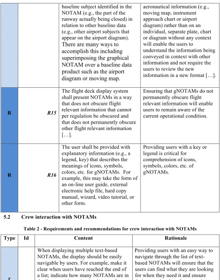
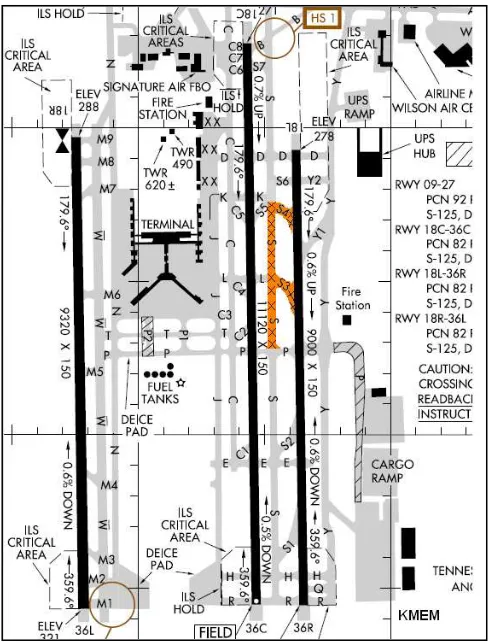
6.1.3 Portrayal proposal
Figure 1 - SAE-G10 proposal for Closed Runway gNOTAMs display
6.1.4 Symbology Encoding
The main requirement for symbology encoding for the Runway Closed NOTAM is to have X's appear superimposed over the length of a closed runway.
A Runway Closed DNOTAM generally contains a reference to the closed runway in the form of a TEMPDELTA timeslice. An intuitive approach to this problem would be to use a Point Symbolizer to style icons along the runway itself. Unfortunately, an AIXM 5.1 feature does not contain a set of points running through the center of the runway. The superimposition of X’s can instead be defined as a new rule using a
PolygonSymbolizer with a specific fill pattern. The OGC filter for this rule requires the runway operational status to be closed, and relies on client support for
For this rule we define the filter based on RunwayElementTimeSlice/
availability/ManoeuvringAreaAvailability/operationalStatus. The rule will apply when the value of this property is CLOSED.
The rule can be applied on top of a base airport layout, but care must be taken that this rule is executed at a later point than the rules for the base runway. Rules inside the same SE file are executed from top to bottom. In other words: this rule needs to be defined below the base rule for runway elements.
We chose an orange color for the X's, to comply with the SAE-G10 guideline examples, and because it contrasts well with the base runway colors. The style overlays X's over the entire runway, as was required by the SAE-G10 document.
On top of that, we also visualize the outline of the runway as thick blue line. This was also inspired by the SAE-G10 guideline examples. (See Figure 1) The blue outlines have the additional advantage of increased noticeability, even when the runway is visualized at a small scale.
The Symbology Encoding rule is provided here:
<Rule>
<Name>runway_closed_rule</Name> <Description>
<Title>Runway Closed NOTAM rule</Title>
<Abstract>Rule to render runways that are closed by superimposing their area with X's and add a blue outline.</Abstract>
</Geometry>
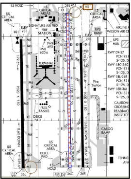
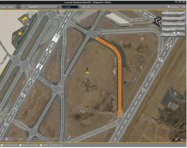
Figure 2 – Luciad Aviation Client visualization of Runway Closure NOTAM using SE 1.1
6.1.5 Problems encountered & proposed solutions
6.1.5.1 Usage of WellKnownName
One issue with the style proposed above is that it is client dependent. The
"WellKnownName" symbol is not fixed in the Symbology Encoding specification. Because of this, the visualization thereof could be different depending on the client implementation, causing inconsistent styling across platforms.
The proposed solution to avoid the potential issue of unknown “WellKnownName” could be to refer to an ExternalGraphic in the rule instead:
<Graphic>
<ExternalGraphic>
<OnlineResource xlink:type="simple" xlink:href="x.png" /> <Format>image/png</Format>
The externally referenced file “x.png” should be a 16x16 png containing a red cross covering the entire image. To ensure that the crosses don’t blend into a single mesh of lines, there should be some spacing between the crosses. This can be encoded in the file itself, as can be seen in Figure 3.
Figure 3 - Example of a 16x16 cross with some spacing
6.1.5.2 Using a fixed pixel GraphicFill
Two problems arise from using a GraphicFill with a fixed pixel size. It means that printing at high-DPI will result in a different style when compared to a low-DPI monitor. Note that a typical modern day monitor uses display resolutions of around 100 DPI, while printing uses resolutions of 300+ DPI.
An SE Symbolizer supports three types of units of measure: pixels, feet and meters. A proposition would be to add a unit of measure that takes into account the pixel density of the device. This would help create more consistent styles across different devices. This could become more important in the future as more high-DPI screens are becoming available on the market.
A second issue with having a pixel sized Fill Graphic is that at certain scales, the Runway Element will be thinner than the Graphic (in pixel coordinates), making the cross pattern unrecognizable.
This issue has been already partially been tackled by the fact that we visualize the outline of a closed runway with a distinct blue color (See figures 1 and 2).
6.2 Displaced threshold runway
6.2.1 Recommendation
6.2.2 Rationale
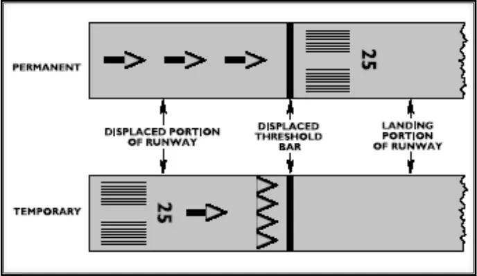
Cues are important to provide users with a way to quickly evaluate the gNOTAM’s implications. Users need to know which portion of the runway is available and which is unavailable for touch down. A displaced threshold gNOTAM should indicate the portion of the runway that is not available for touchdown and should be drawn to scale to provide an indication of the portion of the runway that is unavailable. This will help ensure that users will be able to see the portion of the runway that is unavailable regardless of the scale of the display, and that they will not be misled regarding the portion available.
6.2.3 Portrayal proposal
One way to depict this is to use a white bar and white arrow heads to indicate the location of the line between the usable and unusable portion, and white arrows to indicate the centerline of the approach direction (see Figure 4). While the gNOTAM may not be able to depict the numerical LDA, if the user needs to know the exact value of the LDA they can return to the text-based NOTAM. While reading the text-based version of the NOTAM to identify the exact values is always required, providing cues (drawing to scale) to users in the gNOTAM will help prevent them from being misled.
Figure 4 - SAE-G10 proposal for Displaced Threshold Runway gNOTAMs display
6.2.4 Symbology Encoding
We turn to the AIXM 5.1 data model to help us visualizing the displaced threshold NOTAM. The AIXM 5.1 data model contains an element that was meant exactly for this scenario: The RunwayMarking.
<aixm:RunwayMarking gml:id="ID001488">
<gml:beginPosition>2010-01-01T00:00:00.000Z</gml:beginPosition> <gml:endPosition indeterminatePosition="unknown"/>
</gml:TimePeriod> </gml:validTime>
</aixm:RunwayMarkingTimeSlice> </aixm:timeSlice>
</aixm:RunwayMarking>
To fully visualize the intended runway markings, it is required that the DNOTAM contains all relevant RunwayMarking elements, as well as their geometry. Including the geometry in the DNOTAM is crucial to correctly visualizing the NOTAM at a correct scale. The geometry can be any GML 3.2-based shape.
It is also important that each of these RunwayMarking elements are correctly linked to a Runway found in the base airport layout. This can be done by filling in the
“markedRunway” property with an xlink. This helps the client correctly identify which RunwayMarkings belong to which Runways.
On top of that, it is also required for the DNOTAM to contain every single
RunwayMarking that it wishes to make invisible. Generally, a Displaced Threshold Runway DNOTAM will want to override some or all existing RunwayMarkings on a Runway. To do this correctly, each existing RunwayMarking that needs to be overridden should be part of the DNOTAM, but with an explicitly empty geometry component. This ensures that the RunwayMarking is invisible for the duration of the TEMPDELTA timeslice update in the client.
An example of how to make a currently visible RunwayMarking temporarily invisible (i.e. to have it replaced by another RunwayMarking) is given below. Notice the empty element property, that overrides any possible geometry associated with the
RunwayMarking:
<aixm:markedRunway xlink:href="#ID001494"/> </aixm:RunwayMarkingTimeSlice>
</aixm:timeSlice> </aixm:RunwayMarking>
Please note that the identifier of this example has to link to a readily available
RunwayMarking in the base dataset. Otherwise, the TEMPDELTA timeslice update will not work correctly. For the example above, it is assumed that a RunwayMarking with identifier “5d1153-a3adcad153-13ca35c35ad” exists in the base dataset. The client uses this information to create SNAPSHOT timeslices for correct visualization of a given time instance.
For the rest of this chapter, it is assumed that incoming DNOTAM notifications contain both the set of the new RunwayMarkings (containing the full geometry of each
RunwayMarking) and a set of RunwayMarkings that should become invisible (With correct identifiers to currently active RunwayMarkings and explicitly empty geometry components).
Once these conditions are met, the SE rules for visualizing RunwayMarking elements is relatively simple. According to SAE-G10 recommendations, they should be filled with a white color. This can be handled with a PolygonSymbolizer. No filter is needed as RunwayMarkings should always be visualized to aid any navigating pilots. An example of this is shown in the example below:
<SvgParameter name="stroke-opacity"> <ogc:Literal>1.0</ogc:Literal> </SvgParameter>
<SvgParameter name="stroke-width"> <ogc:Literal>1</ogc:Literal> </SvgParameter>
<SvgParameter name="stroke">
<ogc:Literal>#FFFFFF</ogc:Literal> </SvgParameter>
</Stroke>
</PolygonSymbolizer> </Rule>
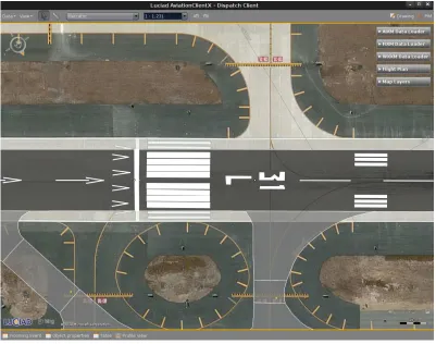
The depiction of the runway markings using SLD/SE in the Luciad Aviation client is shown in Figure 5. The RunwayMarking elements are visualized on top of the base RunwayElements. This is achieved in the client by making sure that RunwayMarkings are painted in a separate layer that is always on top of RunwayElements.
Note that the RunwayMarking feature in the AIXM 5.1 data model does contain a
“colour” property per markingElement. It was chosen for this testbed to disregard this for the SE file defined above. While this “colour” property can easily be part of SE-based visualization, we chose to follow the SAE-G10 guidelines to always visualize
Figure 5 - Luciad Aviation Client visualization of Displaced Threshold Runway using SE 1.1
6.2.5 Problem encountered
While not strictly a problem, it should be noted that for this testbed we didn’t have a clear example of a DNOTAM event to test our portrayal on. For this reason the assumptions we make in the previous section are also recommendations for how to transmit
RunwayMarking information using DNOTAM messages. 6.2.6 Proposed solution
As mentioned in section 6.2.46.3.4, the following information should be transmitted in the DNOTAM message for correct portrayal in a client:
Each new RunwayMarking that needs to be visualized needs to be included in the DNOTAM message as a TEMPDELTA timeslice, with information on their total timeframe, as well as the geometry. If new RunwayMarkings are defined, their identifiers should be globally unique and new.
Each RunwayMarking that needs to be overridden, as a result of the DNOTAM message, should also be included in the DNOTAM message. These
given with an empty set of geometry components. (Example can be found in section 6.2.4).
6.3 Runway shortened
6.3.1 Recommendation
A shortened runway gNOTAM should indicate the portion of the runway that is closed and should be drawn to scale to provide an indication of which portion is available and which is closed. This will help users comprehend the portion of the runway that is closed regardless of the scale of the display.
6.3.2 Rationale
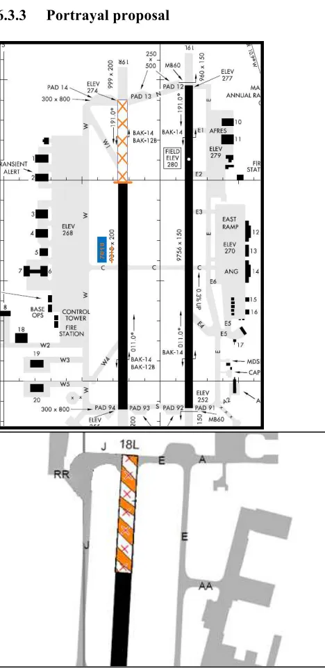
6.3.3 Portrayal proposal
Figure 6 - SAE-G10 proposals for Partially Closed Runway gNOTAMs display
6.3.4 Symbology Encoding
The interpretation of such a NOTAM is that 400 feet to the south of the runway 1C/19C is closed, between the 18/03/2014 at 00:47 and the 21/03/2014 at 12:00.
The SAE-G10 recommends that the unusable part of the runway be emphasized.
It is important to note that as far as the AIXM 5.1 domain model is concerned, there is no distinction between a partially closed RunwayElement, and a fully closed
RunwayElement. In both cases the only piece of available information is the
operationalStatus of the ManoeuvringAreaAvailability property. This is either closed or not.
For this reason, it is currently not possible to have a separate visualization for Runway Shortened DNOTAM and Runway Closure DNOTAM. We subsequently chose to re-use the same Symbology Encoding Rule for Runway Shortened. We refer the reader to section 6.1.4 for an explanation on how to visualize closed runways according to SAE-G10 guidelines.
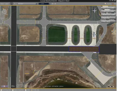
One other problem we faced is that in the Runway Shortened DNOTAMs examples we received, it was not entirely possible to visualize the DNOTAM right out-of-the-box using the DNOTAM 2.0 guidelines and AIXM 5.1 temporality model. The problem is that in order for a part of a runway to be closed, a DNOTAM message has to be produced that contains the exact portion of the runway that should be closed. This could either be done by splitting up the runway into smaller fixed-length segments in advance, or by superimposing a new RunwayElement over the base runway. More information on this is given in the next sections.
Figure 7 - Luciad Aviation Client visualization of Runway Shortened NOTAM using SE 1.1
6.3.5 Problem encountered
As mentioned in the previous section, there is currently no way to differentiate between a closed runway and a partially closed runway, as both are based on the
ManoeuvringAreaAvailability set to CLOSED. Since both visualizations are similar however, we believe that is possible to use the same visualization for both DNOTAMs. A second issue we encountered is lack of an exact definition of what a Runway
Shortened DNOTAM should contain in terms of updates to AIXM 5.1 RunwayElement. We briefly touched on this subject in the previous section, and offer 2 possible solutions in the next section.
6.3.6 Proposed solution
reference to the identifier for each RunwayElement section of the base runway that needs to be closed. This way, there is no distinction between Runway Shortened and Runway Closure as far as functionality and portrayal is concerned. The advantage here is that there is reduced complexity, as existing functionality is re-used.
If on the other hand granularity of Runway Shortened NOTAMS is very fine-grained (e.g. with 1 foot accuracy), then a second option might to supply the geometry of a new RunwayElement as a superposition over the current RunwayElement. It is crucial for this case that the full geometry of this new RunwayElement is supplied in the DNOTAM message. This geometry should represent the closed part of the Runway. The client will draw the closed part of the RunwayElement over the existing RunwayElement.
Besides being more accurate, the second option also has the added benefit of being more flexible with runway base-data that is not split up into smaller RunwayElement sections. It requires less work to process base-data that already exists.
For this testbed we chose to use the second alternative, as we didn’t have readily available base data where the runway elements were split up in fixed lengths.
6.4 Taxiway closure
6.4.1 Recommendation
The gNOTAM of a closed taxiway should indicate that the entire taxiway is closed, ensuring that users will be able to see that the taxiway is closed regardless of the scale of the display. One way to accomplish this is to superimpose X’s over the entire length of the closed taxiway rather than just at the end of the taxiway.
6.4.2 Rationale
6.4.3 Portrayal proposal
Figure 8 - SAE-G10 proposal for Closed Taxiway gNOTAMs display
6.4.4 Symbology Encoding
Taxiway Closed NOTAM is similar to Runway Closed NOTAM, and as such, any remarks mentioned in section 6.1 are also valid here.
To adhere to the examples given in the SAE-G10 guidelines document (See Figure 8), we chose to visualize taxiway closure DNOTAMs with an orange background fill pattern, with black crosses on top of them.
The orange background visualization has the added benefit that it can easily be distinguished from runways, as well as taxiways that are not closed.
An example of the Taxiway closed NOTAM can be found here:
<Name>taxiway_closed_rule</Name> <Description>
<Title>Taxiway Closed NOTAM rule</Title>
<Abstract>Rule to render taxiway that are closed by superimposing their area with X's, and rendering them on an orange background</Abstract>
</Description>
<SvgParameter name="stroke">#000000</SvgParameter> <SvgParameter name="stroke-width">1</SvgParameter> </Stroke>
</Mark>
<Size>16</Size> </Graphic>
</GraphicFill> </Fill>
</PolygonSymbolizer> </Rule>
As mentioned in the Runway Closure section, it is possible to use an ExternalGraphic (see Figure 9) instead of a Mark fill with a WellKnownName. This actually simplifies the SE rule because the orange background can be part of the image used to define the cross (See figure 9). An example of this can be found in section 6.1on Runway Closure NOTAM. See Figure 10 for representation of a Taxiway closure in the Luciad client.
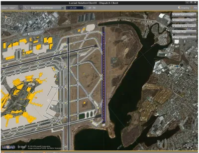
Figure 10 - Luciad Aviation Client visualization of Taxiway closed
6.4.5 Problem encountered & proposed solutions
The strategy used here being the same as for the Runway Closed DNOTAMs, please refer to the section 6.1.5 for encountered problems and proposed solutions.
6.5 Temporary Flight Restriction
6.5.1 Recommendation
The NOTAM display should clearly define the subject in TFR gNOTAMs by providing both the horizontal boundaries (latitude and longitude) and the vertical boundaries (lower and upper altitudes) when they are superimposed over baseline products (e.g., sectional chart, moving map).
6.5.2 Rationale
6.5.3 Portrayal proposal
Figure 11 - SAE-G10 proposal for TFR gNOTAMs display
6.5.4 Symbology Encoding
Looking closely at the examples given by the SAE-G10 guideline document, we notice that we can split the visualization up into two components.
The first component is the easiest: A thick red outline. For this we use LineSymbolizer with pixel width 3. The thick nature of the line makes it very noticeable at any scale. The second component is a bit more complex. We can represent the hatching pattern as a very wide dashed line. For this we use a LineSymbolizer with a Stroke that represents a dashed red stroke. The width of the stroke is the length of the inclined lines. We can use the perpendicularOffset property to make sure the line inclinations are on the inside of the airspace, by using a negative perpendicularOffset equal to half the width of the stroke. It is important for a client to correctly interpret the perpendicularOffset property. A positive value will should make a stroke appear on the outside of the polygon, while a negative value should make a stroke appear on the inside of the polygon.
The distinction is important because we need to be easily able to identify which part of the airspace is inside. It is common for airspaces to touch each other at their boundaries, so without correct functioning of the perpendicularOffset property, it would be
impossible to tell what is the inside and what is the outside of an airspace at certain scales.
The Symbology Encoding rule for this is shown below: <Rule>
<Title>Temporary Flight Restriction Rule</Title>
<Abstract>Rule to render Temporary Flight Restriction DNOTAM as a red line with inclined red hashed lines inside the restricted airspace.</Abstract>
<SvgParameter name="stroke-opacity"> <ogc:Literal>1.0</ogc:Literal> </SvgParameter>
<SvgParameter name="stroke-dasharray">2 8</SvgParameter> </Stroke>
<PerpendicularOffset>-5.0</PerpendicularOffset> </LineSymbolizer>
</Rule>
An example of this rule in the Luciad Aviation Client can be seen in Figure 12. The figure demonstrates that the rule can work well for airspaces, even if they have high complexity in their geometry.
Figure 12 - Luciad Aviation Client portrayal of TFR NOTAM using Symbolgy Encoding 1.1
6.5.5 Problem encountered
6.5.6 Proposed solution
N/A
6.6 Changes to an Instrument Approach Procedure (IAP)
6.6.1 Recommendation
The flight deck display system should provide a filter function as part of the NOTAM capabilities that allows users to filter out NOTAMs not associated with the selected IAP (e.g., changes associated with minima, changes to missed approach procedures and new requirements (e.g., DME, radar)).
6.6.2 Rationale
Section 6 identifies basic filtering functionality as a desirable subject. However, IAPs are often associated with a large subset of elements such as frequencies, runways, approach procedures, approach lighting systems, etc. Providing this additional filtering function will allow users to further refine the NOTAMs that are shown, thus reducing the burden of managing irrelevant information.
6.6.3 Portrayal proposal
Figure 13 - SAE-G10 proposal for IAP change gNOTAMs display
6.6.4 Symbology Encoding
7 Conclusion
The investigation documented in the ER allowed demonstrating that a majority of the guidelines enounced in the ARP 6467 can be complied with using the Symbology Encoding Standard.
For the recommendations that could not be complied with, the nature of the problem took different forms: Either there were no practical examples of the NOTAM category tackled by the ARP (that is the case of the change of IAP NOTAM), or the NOTAM lacked sufficient amount of information to create a SE rule to abide the recommendation (for instance in the Runway Shortened case). In the first case, further work needs to be done for the definition of the digital version of the considered NOTAM. In the second case, several options could be considered. In this report we provide guidelines and recommendations on the correct structuring of DNOTAM events to ensure that they properly work with the AIXM 5.1 temporality model.
On the portraying part, attention needs to be taken in the client implementation to ensure readability of the information conveyed by the DNOTAM. This is the case for the depiction of X’s on a closed runway or taxiway: varying resolution of the display hardware or of the application may result in loss of understandability of the information. This could be tackled in the future by improving the SE standard, providing the possibility to have rules depending on the pixel density of the display for instance. Attention also needs to be paid on the usage of SE rules properties, such as the perpendicularOffset. A misusage may result in loss of readability.
Overall, the Symbology Encoding standard is deemed exhaustive enough to address the recommendations and requirements of the SAE-G10 ARP6467. Additions may need to be made to the AIXM and DNOTAM standards, to ensure that the features required for SE rule generation are mandatory in the content of the DNOTAM.
Bibliography
[1] Guidelines for Successful OGC Interface Standards, OGC document 00-014r1 [2] FAA Human Factors Design Standard (HFDS)
[3] Electronic Aeronautical Symbols, SAE document ARP 5289
[4] Electronic Display of Aeronautical Information (Charts), SAE document ARP 5621