Open Geospatial Consortium
Publication Date: 2014-07-16
Approval Date: 2014-05-14
Posted Date: 2014-04-15
Reference number of this document: OGC 14-038r1
Reference URL for this document: http://www.opengeospatial.net/doc/PER/testbed10/wcs-wgds-adapter
Category: Public Engineering Report
Editor:
Mark Hughes
OGC
®
Testbed 10 Engineering Report:
Aviation Dissemination of Weather Data
Copyright © 2014 Open Geospatial Consortium.
To obtain additional rights of use, visit http://www.opengeospatial.org/legal/.
Warning
This document is not an OGC Standard.
This document presents a discussion of
technology issues considered in an initiative of the OGC Interoperability Program.
This document does not represent an official position of the OGC. It is subject to
change without notice and may not be referred to as an OGC Standard. However,
the discussions in this document could very well lead to the definition of an OGC
Standard.
Document type:
OGC
®Engineering Report
Document subtype:
NA
Document stage:
Approved for public release
License Agreement
Permission is hereby granted by the Open Geospatial Consortium, ("Licensor"), free of charge and subject to the terms set forth below, to any person obtaining a copy of this Intellectual Property and any associated documentation, to deal in the Intellectual Property without restriction (except as set forth below), including without limitation the rights to implement, use, copy, modify, merge, publish, distribute, and/or sublicense copies of the Intellectual Property, and to permit persons to whom the Intellectual Property is furnished to do so, provided that all copyright notices on the intellectual property are retained intact and that each person to whom the Intellectual Property is furnished agrees to the terms of this Agreement.
If you modify the Intellectual Property, all copies of the modified Intellectual Property must include, in addition to the above copyright notice, a notice that the Intellectual Property includes modifications that have not been approved or adopted by LICENSOR. THIS LICENSE IS A COPYRIGHT LICENSE ONLY, AND DOES NOT CONVEY ANY RIGHTS UNDER ANY PATENTS THAT MAY BE IN FORCE ANYWHERE IN THE WORLD.
THE INTELLECTUAL PROPERTY IS PROVIDED "AS IS", WITHOUT WARRANTY OF ANY KIND, EXPRESS OR IMPLIED, INCLUDING BUT NOT LIMITED TO THE WARRANTIES OF MERCHANTABILITY, FITNESS FOR A PARTICULAR PURPOSE, AND NONINFRINGEMENT OF THIRD PARTY RIGHTS. THE COPYRIGHT HOLDER OR HOLDERS INCLUDED IN THIS NOTICE DO NOT WARRANT THAT THE FUNCTIONS CONTAINED IN THE INTELLECTUAL PROPERTY WILL MEET YOUR REQUIREMENTS OR THAT THE OPERATION OF THE INTELLECTUAL PROPERTY WILL BE
UNINTERRUPTED OR ERROR FREE. ANY USE OF THE INTELLECTUAL PROPERTY SHALL BE MADE ENTIRELY AT THE USER’S OWN RISK. IN NO EVENT SHALL THE COPYRIGHT HOLDER OR ANY CONTRIBUTOR OF
INTELLECTUAL PROPERTY RIGHTS TO THE INTELLECTUAL PROPERTY BE LIABLE FOR ANY CLAIM, OR ANY DIRECT, SPECIAL, INDIRECT OR CONSEQUENTIAL DAMAGES, OR ANY DAMAGES WHATSOEVER RESULTING FROM ANY ALLEGED INFRINGEMENT OR ANY LOSS OF USE, DATA OR PROFITS, WHETHER IN AN ACTION OF CONTRACT, NEGLIGENCE OR UNDER ANY OTHER LEGAL THEORY, ARISING OUT OF OR IN CONNECTION WITH THE IMPLEMENTATION, USE, COMMERCIALIZATION OR PERFORMANCE OF THIS INTELLECTUAL PROPERTY. This license is effective until terminated. You may terminate it at any time by destroying the Intellectual Property together with all copies in any form. The license will also terminate if you fail to comply with any term or condition of this Agreement. Except as provided in the following sentence, no such termination of this license shall require the termination of any third party end-user sublicense to the Intellectual Property which is in force as of the date of notice of such termination. In addition, should the Intellectual Property, or the operation of the Intellectual Property, infringe, or in LICENSOR’s sole opinion be likely to infringe, any patent, copyright, trademark or other right of a third party, you agree that LICENSOR, in its sole discretion, may terminate this license without any compensation or liability to you, your licensees or any other party. You agree upon termination of any kind to destroy or cause to be destroyed the Intellectual Property together with all copies in any form, whether held by you or by any third party. Except as contained in this notice, the name of LICENSOR or of any other holder of a copyright in all or part of the Intellectual Property shall not be used in advertising or otherwise to promote the sale, use or other dealings in this Intellectual Property without prior written authorization of LICENSOR or such copyright holder. LICENSOR is and shall at all times be the sole entity that may authorize you or any third party to use certification marks, trademarks or other special designations to indicate compliance with any LICENSOR standards or specifications.
This Agreement is governed by the laws of the Commonwealth of Massachusetts. The application to this Agreement of the United Nations Convention on Contracts for the International Sale of Goods is hereby expressly excluded. In the event any provision of this Agreement shall be deemed unenforceable, void or invalid, such provision shall be modified so as to make it valid and enforceable, and as so modified the entire Agreement shall remain in full force and effect. No decision, action or inaction by LICENSOR shall be construed to be a waiver of any rights or remedies available to it.
Contents
Page
1
Introduction ... 1
1.1
Scope ... 1
1.2
Document contributor contact points ... 2
1.3
Revision history ... 2
1.4
Forward ... 2
2
References ... 2
3
Terms and definitions ... 3
4
Conventions ... 4
4.1
Abbreviated terms ... 4
4.2
UML notation ... 5
5
Overview ... 6
6
Analysis of WGDS functionality ... 7
6.1
The usability and suitability of WGDS schema and encoded documents ... 7
6.2
WFDS in comparison to established OGC standards ... 7
7
Description of the Service Adaptor ... 8
7.1
How to send a coordinate list to the DescribeCoverage operation ... 8
7.2
How to return the weather element in WCS DescribeCoverage response ... 8
7.3
How to expose the parameters of a WGDS getWGDSCoverage in a WCS
GetCoverage request ... 9
7.4
GetCapabilities ... 10
7.4.1
WCS GetCapabilities request – HTTP GET ... 11
7.4.2
WGDS GetCapabilities request – SOAP ... 11
7.4.3
WGDS GetCapabilities response ... 11
7.4.4
WCS response ... 12
7.5
DescribeCoverage ... 13
7.5.1
WCS DescribeCoverage request – HTTP GET ... 14
7.5.2
WGDS DescribeCoverage request ... 14
7.5.3
WGDS DescribeCoverage response ... 15
7.5.4
WCS DescribeCoverage response ... 15
7.6
GetCoverage ... 16
7.6.1
WCS GetCoverage request – HTTP GET ... 16
7.6.2
WGDS GetCoverage request ... 16
7.6.3
WGDS GetCoverage response ... 17
7.6.4
WCS GetCoverage response ... 21
8
Conclusions ... 25
Figures
Page
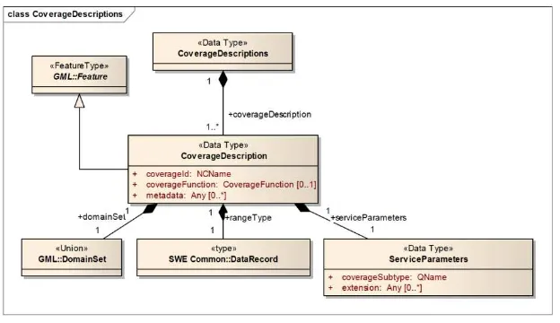
Fig. 1 CoverageDescriptions UML class diagram (OGC 09-110r3)
7
Fig. 2 WCS Adapter implementation scenario – GetCapabilities operation
11
Fig. 3 WCS Adapter implementation scenario – DescribeCoverage operation
13
Fig. 4 WCS Adapter implementation scenario – GetCoverage operation
16
Fig. 5 The WGDS adaptor in the OGC architecture
25
Fig. 5 Example of a BBox query sent from an aviation client
26
Tables
Page
Table 1 Abbreviated Terms ... 4
Table 2 Mapping between WGDS API and WCS API ... 10
OGC
®
Testbed 10 Engineering Report: Aviation Dissemination
of Weather Data
Abstract
This OGC document provides an analysis of the mapping between the NOAA Web
Gridded Document Service (WGDS) and the OGC Web Coverage Service (WCS) and
describes an adapter which translates WCS 2.0 requests to WGDS requests and then
translates WGDS responses to WCS 2.0 responses.
This Engineering Report was prepared as a deliverable for the OGC Testbed 10
(Testbed-10) initiative, specifically the Testbed 10 Aviation Thread.
Keywords
ogcdoc, ogc document, wcs, wgds, Testbed10, aviation, weather
1
Introduction
1.1
Scope
This Engineering Report (ER) describes the results of the Aviation Thread of OGC
Testbed 10, Aviation Dissemination of Weather Data.
This ER reports:
An analysis to which extent Web Gridded Document Service (WGDS)
functionality, models and operation parameters map to elements of the WCS 2.0
model and the GML Application Schema for Coverages.
1.2
Document contributor contact points
All questions regarding this document should be directed to the editor or the contributors:
Name
Organization
Ronald Berger
Frequentis Vienna
MarkHughes
Frequentis California
Yuanzheng Shao
George Mason University
1.3
Revision history
Date
Release
Editor
Primary
clauses
modified
Description
01/29/14
1.0
Mark Hughes
Initial release
03/20/14
1.1
Ronald Berger
7.6.4
Correction of getCoverage response XML
1.4
Forward
Attention is drawn to the possibility that some of the elements of this document may be
the subject of patent rights. The Open Geospatial Consortium shall not be held
responsible for identifying any or all such patent rights.
Recipients of this document are requested to submit, with their comments, notification of
any relevant patent claims or other intellectual property rights of which they may be
aware that might be infringed by any implementation of the standard set forth in this
document, and to provide supporting documentation.
2
References
The following documents are referenced in this document. For dated references,
subsequent amendments to, or revisions of, any of these publications do not apply. For
undated references, the latest edition of the normative document referred to applies.
OGC 06-121r3,
OGC
®Web Services Common Standard
OGC 09‐146r2, OGC® GML Application Schema – Coverages
OGC 07-011, OGC® Abstract Specification Topic 6: Schema for coverage
geometry and functions
OGC 09-110r4 - OGC WCS 2.0 Interface Standard- Core: Corrigendum
OGC 09-153r1 - OGC Web Coverage Service 2.0 Primer: Core and Extensions
OGC 12-040 - OGC Web Coverage Service Interface Standard - Range
Subsetting Extension
3
Terms and definitions
For the purposes of this report, the definitions specified in Clause 4 of the OWS Common
Implementation Standard [OGC 06-121r3] shall apply. In addition, the following terms
and definitions apply.
3.1 Web Coverage Service (WCS)
The Web Coverage Service Interface Standard (WCS) defines Web-based retrieval of
coverages – that is, digital geospatial information representing space/time-varying
phenomena. A WCS provides access to coverage data in forms that are useful for
client-side rendering, as input into scientific models, and for other clients. A WCS allows
clients to choose portions of a server's information holdings based on spatial constraints
and other query criteria.
3.2 Web Gridded Document Service (WGDS)
The WGDS will conform to the basic service model of a Web Coverage Service (WCS).
The backing store will be gridded data from NDFD and National Digital Guidance
Database. WGDS will respond to the WCS operations GetCapabilities,
DescribeCoverage, and GetCoverage. Responses to the GetCoverage operation will be
XML documents encoded in OGC compliant Weather Exchange Model (WXXM) XML.
In general, responses to GetCoverage operations will be valid at a single point on the
NDFD grid.
3.3 Coverage
The concept of a coverage is central to the representation of many common weather
observations and forecasts. Weather datasets that fall into the category of coverages
include point measurements, wind profiles, model grids, and time series measurements at
a single point. Of particular interest to aviation are weather properties observed or
forecast along a trajectory, which can also be represented as a coverage. Coverages are
defined in ISO 19123
3.4 UML notation
4
Conventions
4.1
Abbreviated terms
AIM
Aeronautical Information Management
AIXM
Aeronautical Information Exchange Model
CSML
Climate Science Modelling Language
DWML
Digital Weather Markup Language
GIS
Geographic Information Systems
GML
Geography Markup Language
GMU
George Mason University
OGC
Open Geospatial Consortium
OWS‐10
OGC Web Services Initiative, Phase 10 (Renamed to Testbed 10)
REST
Representational State Transfer
SOAP
Simple Object Adapter Protocol
SWIM
System Wide Information Management
UML
Unified Modeling Language
WCPS
Web Coverage Processing Service
WCS
Web Coverage Service
WFS
Web Feature Service
WMS
Web Map Service
WSDL
Web Services Description Language
WXCM
Weather Conceptual Model
WXSM
Weather Exchange Schema
WXXM
Weather Exchange Model
4.2
UML notation
5
Overview
In 2004, the NOAA's National Weather Service (NWS) created its Digital Services
Program to meet their customers’ increasing need for digital weather, water, and climate
services. The foundation of this program is the National Digital Forecast Database
(NDFD). NDFD is a set of gridded forecasts of sensible weather elements. It contains a
seamless mosaic of digital forecasts from NWS field offices working in collaboration
with the National Centers for Environmental Prediction (NCEP). A companion to NDFD
is the National Digital Guidance Database (NDGD) which contains guidance forecasts in
gridded formats that are interoperable with NDFD.
This NDFD web service services millions of hits each day. Unfortunately, it is not OGC
compliant. None of the established service models appears to fully support the functional
requirements. The closest match seems to be Web Coverage Service (WCS). In response
to this gap, the NWS has developed the Web Gridded Document Service (WGDS).
The WGDS implements a service model that is reminiscent of the Web Coverage
Service, i.e., the WGDS responds to operations similar to getCapabilities,
describeCoverage, and getCoverage.
6
Analysis of WGDS functionality
6.1
The usability and suitability of WGDS schema and encoded documents
The schemas defined by the WGDS are
WGDS.xsd (top level)
wgdsGetCapabilities.xsd
wgdsDescribeCoverage.xsd
wgdsGetCoverage.xsd
Although these schemas do not conform to the WCS 2.0 standard, they are similar and
the content can be extracted and mapped to the WCS counterpart. This ER demonstrates
how this is done in the adapter presented below.
6.2
WFDS in comparison to established OGC standards
WGDS uses the concept of a “product” to describe the four different data products to be
served, and for each product, a list of matched data will be returned in the
DescribeCoverage response. Each matched data is treated as coverage, and is assigned a
unique coverage identifier. This violates the OGC specification because the multiplicity
of the coverage identifier is one (mandatory). Based on the OGC WCS specification, the
coverage identifier is required and is mandatory in the GetCapabilities response. But the
WGDS GetCoverage response does NOT contain such coverage identifier information.
To make it OGC-compliant, the products shall be treated as virtual coverages, and will be
listed in the GetCoverage response.
7
Description of the Service Adaptor
7.1
How to send a coordinate list to the DescribeCoverage operation
The inputs to the WGDS describeWGDSCoverage request are:
1.
One of the 4 types of product coverage identifiers: time-series meteogram, glance
meteogram, 12 hourly summary, 24 hourly summary.
2.
List of latitude/longitude point(s) user requests data for.
The WCS specification does not define a parameter to send coordinates (point only)
transparently. The parameter “subset” will be used to specify the coordinates of interest.
For example:
subset=point,EPSG:4326(38,-99)&subset=point,EPSG:4326(18,-66)
Multiple “subset” parameters can be encoded in the HTTP Get request, each one is
corresponding to one point. The order of the coordinates is: (latitude, longitude),
separated by comma.
7.2
How to return the weather element in WCS DescribeCoverage response
The element “rangeType “, with the definition “Range structure description of this
coverage”, is a mandatory element defined in the DescribeCoverage response. The
weather elements are important attributes for each product. The response to
DescribeCoverage will include the weather element as a field in a <rangeType> element.
The following XML segment is a sample of a rangeType:
<gmlcov:rangeType> <swe:DataRecord>
<swe:field name="maxt"> <swe:Category>
<swe:identifier>maxt</swe:identifier>
<swe:description>Conus Maximum Temperature (maxt)</swe:description> </swe:Category>
</swe:field>
<swe:field name="mint"> <swe:Category>
<swe:identifier>mint</swe:identifier>
<swe:description>Conus Minimum Temperature (mint)</swe:description> </swe:Category>
</swe:field>
<swe:field name="temp"> <swe:Category>
<swe:identifier>temp</swe:identifier>
<swe:description>Conus Temperature (temp)</swe:description> </swe:Category>
</swe:field>
<swe:field name="dew"> <swe:Category>
<swe:identifier>dew</swe:identifier>
<swe:description>Conus Dew Point Temperature (dew)</swe:description> </swe:Category>
<swe:field name="appt"> <swe:Category>
<swe:identifier>appt</swe:identifier>
<swe:description>Conus Apparent Temperature (appt)</swe:description> </swe:Category>
</swe:field>
<swe:field name="qpf"> <swe:Category>
<swe:identifier>qpf</swe:identifier>
<swe:description>Conus Qualitative Precipitation Forecast (qpf)</swe:description> </swe:Category>
</swe:field>
<swe:field name="icons"> <swe:Category>
<swe:identifier>icons</swe:identifier>
<swe:description>Conus Weather Conditions Icons (icons)</swe:description> </swe:Category>
</swe:field> </swe:DataRecord> </gmlcov:rangeType>
If the product is a "time-series meteogram", a user can choose as many different weather
elements as they want returned (up to 49 weather elements, dependent on sector or
geographic area lat/lon chosen is in). If the product is one of the other 3 types, a user
cannot choose different weather elements. This means certain elements are returned all
the time (default).
If the product is a "glance meteogram", all these elements are returned all the time
(default): Max Temp, Min Temp, Cloud (sky) Coverage, Weather, Icons, and Hazards.
If the product is a "12 hourly summary" or a "24 hourly summary", all these elements are
returned all the time (default): Max Temp, Min Temp, 12 Hourly Probability of
Precipitation, Weather (summarized form), Icons (Summarized), and Hazards
(Summarized across 12 or 24 hour forecast periods (6AM to 6AM for a 24 hourly
summary product; 6AM to 6PM, then 6PM to 6AM, repeating for a 12 hourly summary
product).
7.3
How to expose the parameters of a WGDS getWGDSCoverage in a WCS
GetCoverage request
The WGDS getWGDSCoverage operation supports multiple inputs which are
inconsistent with the WCS GetCoverage interface.
The inputs to the getWGDSCoverage request are:
1.
One of the 4 types of product identifier: time-series meteogram, glance
meteogram, 12 hourly summary, 24 hourly summary.
2.
A list of latitude/longitude point(s) user requests data for.
3.
Time Info in dateTime form (2013-08-01T08:00:00).
5.
Unit:The Unit defaults to English ("e") U.S. standard units if the XMLDocType
chosen is "WXXM"
It’s a major issue to expose these parameters in WCS GetCoverage request without
breaking the WCS specification.
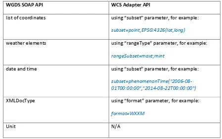
The following table describes the mapping relation between the native WGDS API and
the WCS API.
WGDS SOAP API
WCS Adapter API
list of coordinates
using “subset” parameter, for example:
subset=point,EPSG:4326(lat,long)
weather elements
using “rangeType” parameter, for example:
rangeSubset=maxt;mint
date and time
using “subset” parameter, for example:
subset=phenomenonTime("2006‐08‐
01T00:00:00","2014‐08‐22T00:00:00")
XMLDocType
using “format” parameter, for example:
format=WXXM
Unit
N/A
Table 2 Mapping between WGDS API and WCS API
7.4
GetCapabilities
The input to the getWGDSCapabilities request is: The name of the service: “WGDS”
Fig. 2 WCS Adapter implementation scenario – GetCapabilities operation
7.4.1
WCS GetCapabilities request – HTTP GET
The client sends a HTTP GET request for WCS capabilities as follows:
http://129.174.131.8:9003/ows10/adapter.do?service=WCS&version=2.0&request=GetC
apabilities
7.4.2
WGDS GetCapabilities request – SOAP
The adapter maps the WCS GetCapabilities request to the WGDS SOAP
getWGDSCapabilities request:
<soapenv:Envelope xmlns:xsi="http://www.w3.org/2001/XMLSchema-instance" xmlns:xsd="http://www.w3.org/2001/XMLSchema"
xmlns:soapenv="http://schemas.xmlsoap.org/soap/envelope/"
xmlns:wgds="http://' . $_SERVER['SERVER_NAME'] . '/php-code/WXXMgen/wsdl/WGDS.wsdl"> <soapenv:Header/>
<soapenv:Body>
<wgds:getWGDSCapabilities
soapenv:encodingStyle="http://schemas.xmlsoap.org/soap/encoding/"> <!-- getWGDSCapabilites input is the name of the service: "WGDS" -->
<service xsi:type="xsd:string">WGDS</service> </wgds:getWGDSCapabilities>
</soapenv:Body> </soapenv:Envelope>
7.4.3
WGDS GetCapabilities response
The getWGDSCapabilities response is returned in the format documented here:
http://www.mdl.nws.noaa.gov/~WGDS/examples/getWGDSCapabilities/wgds_response
getcapabilities.xml.txt
WCS GetCapabilities
response (4)
WGDS
GetCapabilities
request (2)
WGDS
GetCapabilities
response (3)
Users
&
Clients
WCS
Adapte
r for
WGDS
WGDS
server
7.4.4
WCS response
The WCS adapter converts the WGDS response to a WCS GetCapabilities response:
<?xml version="1.0" encoding="UTF-8"?>
<wcs:Capabilities version="2.0.0" xmlns:gml="http://www.opengis.net/gml/3.2" xmlns:gmlcov="http://www.opengis.net/gmlcov/1.0"
xmlns:ogc="http://www.opengis.net/ogc"
xmlns:ows="http://www.opengis.net/ows/2.0" xmlns:swe="http://www.opengis.net/swe/2.0" xmlns:wcs="http://www.opengis.net/wcs/2.0"
xmlns:wcseo="http://www.opengis.net/wcseo/1.0" xmlns:xlink="http://www.w3.org/1999/xlink"
xmlns:xsi="http://www.w3.org/2001/XMLSchema-instance" xsi:schemaLocation="http://www.opengis.net/wcs/2.0 http://schemas.opengis.net/wcs/2.0/wcsAll.xsd"> <ows:ServiceIdentification>
<ows:Title>NNEW Web Gridded Document Service 1.0 (WGDS)</ows:Title>
<ows:Abstract>This is a trimmed down implementation of the WCS 1.1.2 specification (see www.opengeospatial.org). The intent of the OGC Web Gridded Document Service (WGDS) is
toprovide gridded national digital forecast data, in four different formats, returned inan OGC compliant WXXM document.</ows:Abstract>
<ows:ServiceType>WGDS</ows:ServiceType>
<ows:ProviderName>Meteorological Development Laboratory (MDL)</ows:ProviderName> <ows:ServiceContact>
<ows:IndividualName>Paul Hershberg</ows:IndividualName> <ows:PositionName>MDL WGDS POC</ows:PositionName> <ows:ContactInfo>
<ows:Phone>
<ows:Voice>301-713-0056 x132</ows:Voice> </ows:Phone>
<ows:Address>
<ows:DeliveryPoint>W/OST24</ows:DeliveryPoint>
<ows:DeliveryPoint>1325 East-West Highway</ows:DeliveryPoint> <ows:City>Silver Spring</ows:City>
<ows:AdministrativeArea>Maryland</ows:AdministrativeArea>
<ows:OnlineResource xlink:type="simple" xlink:href="http://www.weather.gov"/> <ows:HoursOfService>9x6x365</ows:HoursOfService>
<ows:ContactInstructions>email</ows:ContactInstructions> </ows:ContactInfo>
<ows:Role>Service provider</ows:Role> </ows:ServiceContact>
</ows:ServiceProvider> <ows:OperationsMetadata>
<ows:Operation name="GetCapabilities"> <ows:DCP>
<ows:HTTP>
<ows:Get xlink:href="http://129.174.131.8:9003/ows10/adapter.do?" xlink:type="simple"/>
</ows:HTTP> </ows:DCP> </ows:Operation>
<ows:Operation name="DescribeCoverage"> <ows:DCP>
<ows:HTTP>
</ows:HTTP> </ows:DCP> </ows:Operation>
<ows:Operation name="GetCoverage"> <ows:DCP>
<ows:HTTP>
<ows:Get xlink:href="http://129.174.131.8:9003/ows10/adapter.do?" xlink:type="simple"/>
7.5
DescribeCoverage
The following figure illustrates how the WCS adapter supports the WCS
DescribeCoverage operation.
Fig. 3 WCS Adapter implementation scenario – DescribeCoverage operation
The coverage identifiers were adjusted to make a valid NCName. The following table
lists the mapping from WGDS native product identifier to WCS coverage identifier.
WCS Coverage
WGDS Product
Sample WCS Rerquest
WCS DescribeCoverage response (4)
WGDS
DescribeCoverage request (2) WGDS
DescribeCoverage response (3)
Users
Identifier
Identifier
time‐series_meteogram
time‐series meteogram http://129.174.131.8:9003/ows10/adapter.do?service=WC
S&version=2.0&request=DescribeCoverage&coverageId=ti
me‐series_meteogram&subset=point,EPSG:4326(38,‐
99)&subset=point,EPSG:4326(18,‐66)
glance_meteogram
glance meteogram
http://129.174.131.8:9003/ows10/adapter.do?service=WC
S&version=2.0&request=DescribeCoverage&coverageId=gl
ance_meteogram&subset=point,EPSG:4326(38,‐
99)&subset=point,EPSG:4326(18,‐66)
12_hourly_summary
12 hourly
summary
http://129.174.131.8:9003/ows10/adapter.do?service=WC
S&version=2.0&request=DescribeCoverage&coverageId=12
_hourly_summary&subset=point,EPSG:4326(38,‐
99)&subset=point,EPSG:4326(18,‐66)
24_hourly_summary
24 hourly
summary
http://129.174.131.8:9003/ows10/adapter.do?service=WC
S&version=2.0&request=DescribeCoverage&coverageId=24
_hourly_summary&subset=point,EPSG:4326(38,‐
99)&subset=point,EPSG:4326(18,‐66)
Table 3 Mapping from WGDS native product id to WCS coverage id
7.5.1
WCS DescribeCoverage request – HTTP GET
The client sends a HTTP GET request for WCS DescribeCoverage as follows:
http://129.174.131.8:9003/ows10/adapter.do?service=WCS&version=2.0&request=Descr
ibeCoverage&coverageId=time-series_meteogram&subset=point,EPSG:4326(38,-99)&subset=point,EPSG:4326(18,-66)
To enable the client to specify a list of latitude/longitude points for the spot of interest,
the “subset” parameter was used in the WCS DescribeCoverage request.
7.5.2
WGDS DescribeCoverage request
The adapter composes and sends a WGDS SOAP wgdsDescribeCoverage request:
<soap:Envelope xmlns:xsi="http://www.w3.org/2001/XMLSchema-instance" xsi:schemaLocation="../wgdsDescribeCoverage.xsd"
xmlns:ns="http://www.opengis.net/wcs/1.1"
xmlns:soap="http://www.w3.org/2003/05/soap-envelope"> <!-- xmlns:ns="http://www.opengis.net/wcs/1.1" xmlns:ns1="http://www.opengis.net/ows/1.1" xmlns:gml="http://www.opengis.net/gml"> --> <soap:Header/>
<soap:Body>
<ns:DescribeCoverage service="WGDS" version="1.0"> <ns:Identifier>meteogram</ns:Identifier>
<ns:Identifier>37.99,-112.2 18,-66</ns:Identifier>
<!-- With this lat/lon list user gives us, we call degrib to find the sector's these points fall into. This will
"/home/nextgen/bin/degrib -Sector -pnt 37.99,-112.2 18,-66" (only applies to meteogram request) -->
</ns:DescribeCoverage> </soap:Body>
</soap:Envelope>
The coverage identifier specified in the WCS DescribeCoverage could be converted to
corresponding identifier in a WGDS SOAP request.
7.5.3
WGDS DescribeCoverage response
The wgdsDescribeCoverage response is returned in the format documented here:
http://www.mdl.nws.noaa.gov/~WGDS/examples/describeWGDSCoverage/wgds_respon
sedescribecoverage_meteogram.xml.txt
7.5.4
WCS DescribeCoverage response
The WCS adapter converts the WGDS response to a WCS DescribeCoverage response:
<?xml version="1.0" encoding="UTF-8"?>
<wcs:CoverageDescriptions xmlns:ogc="http://www.opengis.net/ogc"
xmlns:ows="http://www.opengis.net/ows/2.0" xmlns:wcs="http://www.opengis.net/wcs/2.0" xmlns:gmlcov="http://www.opengis.net/gmlcov/1.0" xmlns:swe="http://www.opengis.net/swe/2.0" xmlns:gml="http://www.opengis.net/gml/3.2" xmlns:xlink="http://www.w3.org/1999/xlink" xmlns:xsi="http://www.w3.org/2001/XMLSchema-instance"
xsi:schemaLocation="www.opengis.net/wcs/2.0 http://schemas.opengis.net/wcs/2.0/wcsAll.xsd"> <wcs:CoverageDescription gml:id="cd_20140110_180146">
<wcs:CoverageId>time-series_meteogram</wcs:CoverageId> <gml:domainSet>
<gml:TimePeriod gml:id="tp_20140110_180146">
<gml:beginPosition>2014-01-10T18:01:00</gml:beginPosition> <swe:field name="maxt"> <swe:Category>
<swe:identifier>maxt</swe:identifier>
<swe:description>Conus Maximum Temperature (maxt)</swe:description> </swe:Category>
</swe:field>
<!-— multiple field elements here --> <swe:field name="cumw50">
<swe:Category>
<swe:identifier>cumw50</swe:identifier>
<swe:description>Puertori Probability of Tropical Cyclone Wind Speed Above 50 Knots (Cumulative) (cumw50)</swe:description> </swe:Category>
</swe:field>
<swe:field name="cumw64"> <swe:Category>
<swe:identifier>cumw64</swe:identifier>
7.6
GetCoverage
The following figure illustrates how the WCS adapter supports the WCS
DescribeCoverage operation.
Fig. 4 WCS Adapter implementation scenario – GetCoverage operation
7.6.1
WCS GetCoverage request – HTTP GET
The client sends a HTTP GET request for WCS GetCoverage as follows:
http://129.174.131.8:9003/ows10/adapter.do?service=WCS&version=2.0.0&request=Get
Coverage&coverageId=time-series_meteogram&subset=point,EPSG:4326(38,-
99)&subset=point,EPSG:4326(18,-
66)&rangeSubset=maxt;mint&format=WXXM&subset=phenomenonTime(“2006-08-01T00:00:00”,”2014-08-22T00:00:00”)
7.6.2
WGDS GetCoverage request
The adapter composes and sends a WGDS SOAP wgdsGetCoverage request:
<soapenv:Envelope xmlns:xsi="http://www.w3.org/2001/XMLSchema-instance" xmlns:xsd="http://www.w3.org/2001/XMLSchema"
xmlns:soapenv="http://schemas.xmlsoap.org/soap/envelope/"
xmlns:wgds="http://' . $_SERVER['SERVER_NAME'] . '/php-code/WXXMgen/wsdl/WGDS.wsdl"> <soapenv:Header/>
<soapenv:Body>
<wgds:getWGDSCoverage soapenv:encodingStyle="http://schemas.xmlsoap.org/soap/encoding/"> <product xsi:type="xsd:string">time-series meteogram</product>
<weatherParameters xsi:type="wgds:weatherParametersType"> <maxt xsi:type="xsd:boolean">?</maxt>
<mint xsi:type="xsd:boolean">?</mint> </weatherParameters>
<listLatLon xsi:type="xsd:string">38,-99 18,-66</listLatLon> <startTime xsi:type="xsd:dateTime">2006-08-01T00:00:00</startTime> <endTime xsi:type="xsd:dateTime">2014-08-22T00:00:00</endTime> <XMLDocType xsi:type="xsd:string">WXXM</XMLDocType>
<Unit xsi:type="xsd:string">e</Unit> </wgds:getWGDSCoverage>
</soapenv:Body> </soapenv:Envelope>
WCS GetCoverage response (4)
WGDS GetCoverage request (2)
WGDS GetCoverage response (3)
Users
&
Clients
WCS
Adapte
r for
WGDS
WGDS
server
7.6.3
WGDS GetCoverage response
An example of a wgdsGetCoverage response is as follows:
<?xml version="1.0" encoding="UTF-8"?>
<SOAP-ENV:Envelope xmlns:SOAP-ENC="http://schemas.xmlsoap.org/soap/encoding/" xmlns:xsi="http://www.w3.org/2001/XMLSchema-instance"
xmlns:xsd="http://www.w3.org/2001/XMLSchema"
xmlns:SOAP-ENV="http://schemas.xmlsoap.org/soap/envelope/"> <SOAP-ENV:Body>
<wgds:getWGDSCoverageResponse
xmlns:wgds="http://' . $_SERVER['SERVER_NAME'] . '/php-code/WXXMgen/wsdl/WGDS.wsdl"> <wgdsGetCoverageOutput>
<ns12:Coverages xsi:schemaLocation="../wgdsGetCoverage.xsd" version="1.1.1"
xmlns:wgds="http://127.0.0.1:8082/php-code/WXXMgen/schema/WGDS.xsd"
<wx:FeatureCollection gml:id="id0"
xsi:schemaLocation="http://www.eurocontrol.int/wx/1.1
<wx:Forecast gml:id="id1"> <om:samplingTime>
<gml:TimePeriod gml:id="id2">
<gml:beginPosition>20140110T000000Z</gml:beginPosition> <om:observedProperty xlink:href="wxont:weather"/>
<om:featureOfInterest>
<wx:AreaOfInterest gml:id="id3"> <gml:location>
<gml:Point gml:id="id4">
<gml:pos>38.000000 -99.000000</gml:pos> </gml:Point>
</gml:location> </wx:AreaOfInterest> </om:featureOfInterest> <om:result>
<wx:FeatureCollection gml:id="id5"> <wx:featureMember>
<wx:PointTimeSeriesCoverage gml:id="id6"> <wx:domainSet>
<nawx:ExtPointTimeSeriesDomain gml:id="id7"> <wx:timePeriod gml:id="id8">
<gml:beginPosition>20140110T000000Z</gml:beginPosition> <gml:endPosition>20140111T000000Z</gml:endPosition> <gml:duration>PT24H</gml:duration>
</wx:timePeriod>
<wx:timePeriod gml:id="id9">
<gml:endPosition>20140112T000000Z</gml:endPosition> <gml:duration>PT24H</gml:duration>
</wx:timePeriod>
<wx:timePeriod gml:id="id10">
<gml:beginPosition>20140112T000000Z</gml:beginPosition> <gml:endPosition>20140113T000000Z</gml:endPosition> <gml:duration>PT24H</gml:duration>
</wx:timePeriod>
<wx:timePeriod gml:id="id11">
<gml:beginPosition>20140113T000000Z</gml:beginPosition> <gml:endPosition>20140114T000000Z</gml:endPosition> <gml:duration>PT24H</gml:duration>
</wx:timePeriod>
<wx:timePeriod gml:id="id12">
<gml:beginPosition>20140114T000000Z</gml:beginPosition> <gml:endPosition>20140115T000000Z</gml:endPosition> <gml:duration>PT24H</gml:duration>
</wx:timePeriod>
<wx:timePeriod gml:id="id13">
<gml:beginPosition>20140115T000000Z</gml:beginPosition> <gml:endPosition>20140116T000000Z</gml:endPosition> <gml:duration>PT24H</gml:duration>
</wx:timePeriod>
<wx:timePeriod gml:id="id14">
<gml:beginPosition>20140116T000000Z</gml:beginPosition> <gml:endPosition>20140117T000000Z</gml:endPosition> <gml:duration>PT24H</gml:duration>
</wx:timePeriod>
<wx:timePeriod gml:id="id15">
<gml:beginPosition>20140117T000000Z</gml:beginPosition> <gml:endPosition>20140118T000000Z</gml:endPosition> <gml:duration>PT24H</gml:duration>
</wx:timePeriod>
<wx:location>38.000000, -99.000000</wx:location> </nawx:ExtPointTimeSeriesDomain>
</wx:domainSet> <wx:rangeSet>
<gml:ValueArray gml:id="id16"> <gml:valueComponent
xlink:title="Daily Maximum Temperature"
xlink:href="http://www.nws.noaa.gov/ndfd/technical.htm#elements"> <gml:QuantityList uom="F">45 54 58 53 49 53 49
47</gml:QuantityList> </gml:valueComponent>
</gml:ValueArray> </wx:rangeSet> <wx:domainSet>
<nawx:ExtPointTimeSeriesDomain gml:id="id17"> <wx:timePeriod gml:id="id18">
<gml:beginPosition>20140110T120000Z</gml:beginPosition> <gml:endPosition>20140111T120000Z</gml:endPosition> <gml:duration>PT24H</gml:duration>
</wx:timePeriod>
<wx:timePeriod gml:id="id19">
<gml:beginPosition>20140111T120000Z</gml:beginPosition> <gml:endPosition>20140112T120000Z</gml:endPosition> <gml:duration>PT24H</gml:duration>
</wx:timePeriod>
<wx:timePeriod gml:id="id20">
<gml:beginPosition>20140112T120000Z</gml:beginPosition> <gml:endPosition>20140113T120000Z</gml:endPosition> <gml:duration>PT24H</gml:duration>
</wx:timePeriod>
<wx:timePeriod gml:id="id21">
<gml:beginPosition>20140113T120000Z</gml:beginPosition> <gml:endPosition>20140114T120000Z</gml:endPosition> <gml:duration>PT24H</gml:duration>
</wx:timePeriod>
<wx:timePeriod gml:id="id22">
<gml:beginPosition>20140114T120000Z</gml:beginPosition> <gml:endPosition>20140115T120000Z</gml:endPosition> <gml:duration>PT24H</gml:duration>
</wx:timePeriod>
<wx:timePeriod gml:id="id23">
<gml:beginPosition>20140115T120000Z</gml:beginPosition> <gml:endPosition>20140116T120000Z</gml:endPosition> <gml:duration>PT24H</gml:duration>
<wx:timePeriod gml:id="id24">
<gml:beginPosition>20140116T120000Z</gml:beginPosition> <gml:endPosition>20140117T120000Z</gml:endPosition> <gml:duration>PT24H</gml:duration>
</wx:timePeriod>
<wx:location>38.000000, -99.000000</wx:location> </nawx:ExtPointTimeSeriesDomain>
</wx:domainSet> <wx:rangeSet>
<gml:ValueArray gml:id="id25"> <gml:valueComponent
xlink:title="Daily Minimum Temperature"
xlink:href="http://www.nws.noaa.gov/ndfd/technical.htm#elements"> <gml:QuantityList uom="F">25 31 28 32 28 32
25</gml:QuantityList>
<wx:Forecast gml:id="id26"> <om:samplingTime>
<gml:TimePeriod gml:id="id27">
<gml:beginPosition>20140110T000000Z</gml:beginPosition> <om:observedProperty xlink:href="wxont:weather"/>
<om:featureOfInterest>
<wx:AreaOfInterest gml:id="id28"> <gml:location>
<gml:Point gml:id="id29">
<gml:pos>18.000000 -66.000000</gml:pos> </gml:Point>
</gml:location> </wx:AreaOfInterest> </om:featureOfInterest> <om:result>
<wx:FeatureCollection gml:id="id30"> <wx:featureMember>
<wx:PointTimeSeriesCoverage gml:id="id31"> <wx:domainSet>
<nawx:ExtPointTimeSeriesDomain gml:id="id32"> <wx:timePeriod gml:id="id33">
<gml:beginPosition>20140110T000000Z</gml:beginPosition> <gml:endPosition>20140111T000000Z</gml:endPosition> <gml:duration>PT24H</gml:duration>
</wx:timePeriod>
<wx:timePeriod gml:id="id34">
<gml:beginPosition>20140111T000000Z</gml:beginPosition> <gml:endPosition>20140112T000000Z</gml:endPosition> <gml:duration>PT24H</gml:duration>
</wx:timePeriod>
<wx:timePeriod gml:id="id35">
<gml:beginPosition>20140112T000000Z</gml:beginPosition> <gml:endPosition>20140113T000000Z</gml:endPosition> <gml:duration>PT24H</gml:duration>
</wx:timePeriod>
<wx:timePeriod gml:id="id36">
<gml:beginPosition>20140113T000000Z</gml:beginPosition> <gml:endPosition>20140114T000000Z</gml:endPosition> <gml:duration>PT24H</gml:duration>
</wx:timePeriod>
<wx:timePeriod gml:id="id37">
<gml:beginPosition>20140114T000000Z</gml:beginPosition> <gml:endPosition>20140115T000000Z</gml:endPosition> <gml:duration>PT24H</gml:duration>
</wx:timePeriod>
<wx:timePeriod gml:id="id38">
</wx:timePeriod>
<wx:timePeriod gml:id="id39">
<gml:beginPosition>20140116T000000Z</gml:beginPosition> <gml:endPosition>20140117T000000Z</gml:endPosition> <gml:duration>PT24H</gml:duration>
</wx:timePeriod>
<wx:timePeriod gml:id="id40">
<gml:beginPosition>20140117T000000Z</gml:beginPosition> <gml:endPosition>20140118T000000Z</gml:endPosition> <gml:duration>PT24H</gml:duration>
</wx:timePeriod>
<wx:location>18.000000, -66.000000</wx:location> </nawx:ExtPointTimeSeriesDomain>
</wx:domainSet> <wx:rangeSet>
<gml:ValueArray gml:id="id41"> <gml:valueComponent
xlink:title="Daily Maximum Temperature"
xlink:href="http://www.nws.noaa.gov/ndfd/technical.htm#elements"> <gml:QuantityList uom="F">79 83 85 82 81 81 81
84</gml:QuantityList> </gml:valueComponent>
</gml:ValueArray> </wx:rangeSet> <wx:domainSet>
<nawx:ExtPointTimeSeriesDomain gml:id="id42"> <wx:timePeriod gml:id="id43">
<gml:beginPosition>20140110T120000Z</gml:beginPosition> <gml:endPosition>20140111T120000Z</gml:endPosition> <gml:duration>PT24H</gml:duration>
</wx:timePeriod>
<wx:timePeriod gml:id="id44">
<gml:beginPosition>20140111T120000Z</gml:beginPosition> <gml:endPosition>20140112T120000Z</gml:endPosition> <gml:duration>PT24H</gml:duration>
</wx:timePeriod>
<wx:timePeriod gml:id="id45">
<gml:beginPosition>20140112T120000Z</gml:beginPosition> <gml:endPosition>20140113T120000Z</gml:endPosition> <gml:duration>PT24H</gml:duration>
</wx:timePeriod>
<wx:timePeriod gml:id="id46">
<gml:beginPosition>20140113T120000Z</gml:beginPosition> <gml:endPosition>20140114T120000Z</gml:endPosition> <gml:duration>PT24H</gml:duration>
</wx:timePeriod>
<wx:timePeriod gml:id="id47">
<gml:beginPosition>20140114T120000Z</gml:beginPosition> <gml:endPosition>20140115T120000Z</gml:endPosition> <gml:duration>PT24H</gml:duration>
</wx:timePeriod>
<wx:timePeriod gml:id="id48">
<gml:beginPosition>20140115T120000Z</gml:beginPosition> <gml:endPosition>20140116T120000Z</gml:endPosition> <gml:duration>PT24H</gml:duration>
</wx:timePeriod>
<wx:timePeriod gml:id="id49">
<gml:beginPosition>20140116T120000Z</gml:beginPosition> <gml:endPosition>20140117T120000Z</gml:endPosition> <gml:duration>PT24H</gml:duration>
</wx:timePeriod>
<wx:location>18.000000, -66.000000</wx:location> </nawx:ExtPointTimeSeriesDomain>
</wx:domainSet> <wx:rangeSet>
<gml:ValueArray gml:id="id50"> <gml:valueComponent
xlink:title="Daily Minimum Temperature"
xlink:href="http://www.nws.noaa.gov/ndfd/technical.htm#elements"> <gml:QuantityList uom="F">72 74 74 74 74 74
</om:result>
7.6.4
WCS GetCoverage response
The native response is missing the namespace “xmlns:xsi”, and had an invalid namespace
of “xmlns:wgds”. The WCS Adapater has corrected these issues. The following XML is
the sample response from a WCS GetCoverage operation.
<?xml version="1.0" encoding="UTF-8"?>
<wx:FeatureCollection gml:id="id0" xsi:schemaLocation="http://www.eurocontrol.int/wx/1.1 ../../WXXM/schemas/1.1/wx/wx.xsd" xmlns:nawx="http://www.faa.gov/nawx/1.4"
xmlns:xlink="http://www.w3.org/1999/xlink" xmlns:gml="http://www.opengis.net/gml/3.2" xmlns:om="http://www.opengis.net/om/1.0/gml32" xmlns:wx="http://www.eurocontrol.int/wx/1.1"> <wx:featureMember>
<wx:Forecast gml:id="id1"> <om:samplingTime>
<gml:TimePeriod gml:id="id2">
<gml:beginPosition>20140110T000000Z</gml:beginPosition> <gml:endPosition>20140118T000000Z</gml:endPosition> </gml:TimePeriod>
</om:samplingTime>
<om:procedure xlink:href="urn:fdc:mdl-nextgen.nws.noaa.gov:Dataset:NDFD"/> <om:observedProperty xlink:href="wxont:weather"/>
<om:featureOfInterest>
<wx:AreaOfInterest gml:id="id3"> <gml:location>
<gml:Point gml:id="id4">
<gml:pos>38.000000 -99.000000</gml:pos> </gml:Point>
</gml:location> </wx:AreaOfInterest> </om:featureOfInterest> <om:result>
<wx:FeatureCollection gml:id="id5"> <wx:featureMember>
<wx:PointTimeSeriesCoverage gml:id="id6"> <wx:domainSet>
<nawx:ExtPointTimeSeriesDomain gml:id="id7"> <wx:timePeriod gml:id="id8">
<gml:beginPosition>20140110T000000Z</gml:beginPosition> <gml:endPosition>20140111T000000Z</gml:endPosition> <gml:duration>PT24H</gml:duration>
</wx:timePeriod>
<wx:timePeriod gml:id="id9">
<gml:beginPosition>20140111T000000Z</gml:beginPosition> <gml:endPosition>20140112T000000Z</gml:endPosition> <gml:duration>PT24H</gml:duration>
</wx:timePeriod>
<wx:timePeriod gml:id="id10">
<gml:beginPosition>20140112T000000Z</gml:beginPosition> <gml:endPosition>20140113T000000Z</gml:endPosition> <gml:duration>PT24H</gml:duration>
</wx:timePeriod>
<wx:timePeriod gml:id="id11">
<gml:beginPosition>20140113T000000Z</gml:beginPosition> <gml:endPosition>20140114T000000Z</gml:endPosition> <gml:duration>PT24H</gml:duration>
</wx:timePeriod>
<wx:timePeriod gml:id="id12">
<gml:beginPosition>20140114T000000Z</gml:beginPosition> <gml:endPosition>20140115T000000Z</gml:endPosition> <gml:duration>PT24H</gml:duration>
</wx:timePeriod>
<wx:timePeriod gml:id="id13">
<gml:duration>PT24H</gml:duration> </wx:timePeriod>
<wx:timePeriod gml:id="id14">
<gml:beginPosition>20140116T000000Z</gml:beginPosition> <gml:endPosition>20140117T000000Z</gml:endPosition> <gml:duration>PT24H</gml:duration>
</wx:timePeriod>
<wx:timePeriod gml:id="id15">
<gml:beginPosition>20140117T000000Z</gml:beginPosition> <gml:endPosition>20140118T000000Z</gml:endPosition> <gml:duration>PT24H</gml:duration>
</wx:timePeriod>
<wx:location>38.000000, -99.000000</wx:location> </nawx:ExtPointTimeSeriesDomain>
</wx:domainSet> <wx:rangeSet>
<gml:ValueArray gml:id="id16">
<gml:valueComponent xlink:title="Daily Maximum Temperature" xlink:href="http://www.nws.noaa.gov/ndfd/technical.htm#elements"> <gml:QuantityList uom="F">45 54 58 53 49 53 49 47</gml:QuantityList> </gml:valueComponent>
</gml:ValueArray> </wx:rangeSet> <wx:domainSet>
<nawx:ExtPointTimeSeriesDomain gml:id="id17"> <wx:timePeriod gml:id="id18">
<gml:beginPosition>20140110T120000Z</gml:beginPosition> <gml:endPosition>20140111T120000Z</gml:endPosition> <gml:duration>PT24H</gml:duration>
</wx:timePeriod>
<wx:timePeriod gml:id="id19">
<gml:beginPosition>20140111T120000Z</gml:beginPosition> <gml:endPosition>20140112T120000Z</gml:endPosition> <gml:duration>PT24H</gml:duration>
</wx:timePeriod>
<wx:timePeriod gml:id="id20">
<gml:beginPosition>20140112T120000Z</gml:beginPosition> <gml:endPosition>20140113T120000Z</gml:endPosition> <gml:duration>PT24H</gml:duration>
</wx:timePeriod>
<wx:timePeriod gml:id="id21">
<gml:beginPosition>20140113T120000Z</gml:beginPosition> <gml:endPosition>20140114T120000Z</gml:endPosition> <gml:duration>PT24H</gml:duration>
</wx:timePeriod>
<wx:timePeriod gml:id="id22">
<gml:beginPosition>20140114T120000Z</gml:beginPosition> <gml:endPosition>20140115T120000Z</gml:endPosition> <gml:duration>PT24H</gml:duration>
</wx:timePeriod>
<wx:timePeriod gml:id="id23">
<gml:beginPosition>20140115T120000Z</gml:beginPosition> <gml:endPosition>20140116T120000Z</gml:endPosition> <gml:duration>PT24H</gml:duration>
</wx:timePeriod>
<wx:timePeriod gml:id="id24">
<gml:beginPosition>20140116T120000Z</gml:beginPosition> <gml:endPosition>20140117T120000Z</gml:endPosition> <gml:duration>PT24H</gml:duration>
</wx:timePeriod>
<wx:location>38.000000, -99.000000</wx:location> </nawx:ExtPointTimeSeriesDomain>
</wx:domainSet> <wx:rangeSet>
<gml:ValueArray gml:id="id25">
<gml:valueComponent xlink:title="Daily Minimum Temperature" xlink:href="http://www.nws.noaa.gov/ndfd/technical.htm#elements"> <gml:QuantityList uom="F">25 31 28 32 28 32 25</gml:QuantityList> </gml:valueComponent>
<om:samplingTime>
<gml:TimePeriod gml:id="id27">
<gml:beginPosition>20140110T000000Z</gml:beginPosition> <gml:endPosition>20140118T000000Z</gml:endPosition> </gml:TimePeriod>
</om:samplingTime>
<om:procedure xlink:href="urn:fdc:mdl-nextgen.nws.noaa.gov:Dataset:NDFD"/> <om:observedProperty xlink:href="wxont:weather"/>
<om:featureOfInterest>
<wx:AreaOfInterest gml:id="id28"> <gml:location>
<gml:Point gml:id="id29">
<gml:pos>18.000000 -66.000000</gml:pos> </gml:Point>
</gml:location> </wx:AreaOfInterest> </om:featureOfInterest> <om:result>
<wx:FeatureCollection gml:id="id30"> <wx:featureMember>
<wx:PointTimeSeriesCoverage gml:id="id31"> <wx:domainSet>
<nawx:ExtPointTimeSeriesDomain gml:id="id32"> <wx:timePeriod gml:id="id33">
<gml:beginPosition>20140110T000000Z</gml:beginPosition> <gml:endPosition>20140111T000000Z</gml:endPosition> <gml:duration>PT24H</gml:duration>
</wx:timePeriod>
<wx:timePeriod gml:id="id34">
<gml:beginPosition>20140111T000000Z</gml:beginPosition> <gml:endPosition>20140112T000000Z</gml:endPosition> <gml:duration>PT24H</gml:duration>
</wx:timePeriod>
<wx:timePeriod gml:id="id35">
<gml:beginPosition>20140112T000000Z</gml:beginPosition> <gml:endPosition>20140113T000000Z</gml:endPosition> <gml:duration>PT24H</gml:duration>
</wx:timePeriod>
<wx:timePeriod gml:id="id36">
<gml:beginPosition>20140113T000000Z</gml:beginPosition> <gml:endPosition>20140114T000000Z</gml:endPosition> <gml:duration>PT24H</gml:duration>
</wx:timePeriod>
<wx:timePeriod gml:id="id37">
<gml:beginPosition>20140114T000000Z</gml:beginPosition> <gml:endPosition>20140115T000000Z</gml:endPosition> <gml:duration>PT24H</gml:duration>
</wx:timePeriod>
<wx:timePeriod gml:id="id38">
<gml:beginPosition>20140115T000000Z</gml:beginPosition> <gml:endPosition>20140116T000000Z</gml:endPosition> <gml:duration>PT24H</gml:duration>
</wx:timePeriod>
<wx:timePeriod gml:id="id39">
<gml:beginPosition>20140116T000000Z</gml:beginPosition> <gml:endPosition>20140117T000000Z</gml:endPosition> <gml:duration>PT24H</gml:duration>
</wx:timePeriod>
<wx:timePeriod gml:id="id40">
<gml:beginPosition>20140117T000000Z</gml:beginPosition> <gml:endPosition>20140118T000000Z</gml:endPosition> <gml:duration>PT24H</gml:duration>
</wx:timePeriod>
<wx:location>18.000000, -66.000000</wx:location> </nawx:ExtPointTimeSeriesDomain>
</wx:domainSet> <wx:rangeSet>
<gml:ValueArray gml:id="id41">
<gml:valueComponent xlink:title="Daily Maximum Temperature" xlink:href="http://www.nws.noaa.gov/ndfd/technical.htm#elements"> <gml:QuantityList uom="F">79 83 85 82 81 81 81 84</gml:QuantityList> </gml:valueComponent>
</gml:ValueArray> </wx:rangeSet> <wx:domainSet>
<nawx:ExtPointTimeSeriesDomain gml:id="id42"> <wx:timePeriod gml:id="id43">
</wx:timePeriod>
<wx:timePeriod gml:id="id44">
<gml:beginPosition>20140111T120000Z</gml:beginPosition> <gml:endPosition>20140112T120000Z</gml:endPosition> <gml:duration>PT24H</gml:duration>
</wx:timePeriod>
<wx:timePeriod gml:id="id45">
<gml:beginPosition>20140112T120000Z</gml:beginPosition> <gml:endPosition>20140113T120000Z</gml:endPosition> <gml:duration>PT24H</gml:duration>
</wx:timePeriod>
<wx:timePeriod gml:id="id46">
<gml:beginPosition>20140113T120000Z</gml:beginPosition> <gml:endPosition>20140114T120000Z</gml:endPosition> <gml:duration>PT24H</gml:duration>
</wx:timePeriod>
<wx:timePeriod gml:id="id47">
<gml:beginPosition>20140114T120000Z</gml:beginPosition> <gml:endPosition>20140115T120000Z</gml:endPosition> <gml:duration>PT24H</gml:duration>
</wx:timePeriod>
<wx:timePeriod gml:id="id48">
<gml:beginPosition>20140115T120000Z</gml:beginPosition> <gml:endPosition>20140116T120000Z</gml:endPosition> <gml:duration>PT24H</gml:duration>
</wx:timePeriod>
<wx:timePeriod gml:id="id49">
<gml:beginPosition>20140116T120000Z</gml:beginPosition> <gml:endPosition>20140117T120000Z</gml:endPosition> <gml:duration>PT24H</gml:duration>
</wx:timePeriod>
<wx:location>18.000000, -66.000000</wx:location> </nawx:ExtPointTimeSeriesDomain>
</wx:domainSet> <wx:rangeSet>
<gml:ValueArray gml:id="id50">
<gml:valueComponent xlink:title="Daily Minimum Temperature" xlink:href="http://www.nws.noaa.gov/ndfd/technical.htm#elements"> <gml:QuantityList uom="F">72 74 74 74 74 74 74</gml:QuantityList> </gml:valueComponent>
</gml:ValueArray> </wx:rangeSet>
</wx:PointTimeSeriesCoverage> </wx:featureMember>
</wx:FeatureCollection> </om:result>