by:
SOIL GENESIS
INTRODUCTION
INTRODUCTION
THE STUDY OF THE FORMATION OF SOIL IN THE LAND SURFACE OF THE EARTH
SOIL GENESIS
SOIL GENESIS
=
PEDOLOGY, IF COMBINED WITH SOIL CLASSIFICATIONFACTOR OF SOIL FORMATION
S= f (Cl, O, pm, r, t)
INTERPRETATION OF SOIL PROFILE DESCRIPTION OF SOIL PROFILE
CONCEPTS OF SOIL GENESIS
THE PRESENT IS THE KEY TO THE PAST
SOIL OF THE EATH ARE NATURAL “CLAY FACTORIES”
PODZOLIZATION
LATERIZATION
EVOLUTION OF EARTS MUST HAVE RESULTED IN A SUCESSION OF SOILS ON A GRAND TIME SCALE
A KNOWLEDGE OF PALEOCOLOGY
(AS FAR BACK AS ONE OR TWO MILLION YEARS BEFORE)
UNIQUE TO SOIL GENESIS
SURFICIAL GAINS OF MATERIALS BY DEPOSITION
SUPERFICIAL LOSSES OF MATERIALS BY
EROSION
ENER GY
GAI NS
LOSES OF WATER
ENER GY LO
SSES
GAINS OF WATER
BIOCYCLING OF MATERIALS
A SOIL AS AN OPEN SYSTEM
INTERSOLUM TRANSFORMATIONS (pedologic weathering, etc.)
GEOCHEMICAL (presoil) WEATHERING,
SUPPLYING MATERIALS OF WATER AND OTHER MATERIALSLEACHING LOSSES INTERSOLUM
METHOD OF SOIL GENESIS STUDY
DEPENDENT VARIABLE
INDEPENDENT VARIABLE
MACRO ANALYSIS
NUMERICAL ANALYSIS
2. PELA
PUKAN
GEOK
IMIA
PELAPUKAN ADALAH DESINTEGRASI KIMIA DAN FISIK DAN
DEKOMPOSISI BATUAN KARENA MINERAL DI DALAM BATUAN
TIDAK SEIMBANG (EQUILIBRIUM) PADA KONDISI SUHU,
TEKANAN DAN KELEMBABAN DI ANTARA ATMOSFIR DAN LITOSFIR.
REAKSI TUNGGAL OKSIDASI
REDUKSI
HIDRASI
SOLUSI
TERJADI DI BAWAH SOLUM ATAU DI HORISON C
A
B
C
R
KAJIAN KUANTITATIF PELAPUKAN GEOKIMIA
ANALISIS TOTAL PENYUSUN MINERAL
ANALISIS TOTAL PENYUSUN MINERAL
BERIKUT TABEL PENGOLAHAN DATA UNTUK PELAPUKAN GEOKIMIA
Batuan...(R)
3. PELAPUKAN PEDOKIMIA
DEFENISI DESINTEGRASI DAN MODIFIKASI KIMIA MINERAL YANG TERJADI DALAM HORISON A DAN B
REAKSI-REAKSI
A. SIKLUS OKSIDASI REDUKSI
B. PEMUNTALAN (SHUTTLING) Al DARI KISI LIAT → OKSIDASI TERHIDRAT
C. PELEPASAN KALIUM DARI MIKA
A. SIKLUS OKSIDASI REDUKSI
Alternasi antara kondisi reduksi dan oksidasi merespon pelepasan
ferrum dan mangan dari mineral primer dan terlokalisasi menjadi
mottle dan konkresi dalam solum tanah.Hasil deskripsi Cate dan
Sukhai (1964) dan Patrick dan Wyatt (1964) terdiri atas: alih tempat
(replacement) Al tertukarkan oleh pertukaran Fe++ pada kondisi
reduksi. Dengan peralihan ke kondisi oksidasi, Ferro tertukarkan
mengantikan dan Al muncul dari kisi liat menggantikan ke
B. PEMUNTALAN (SHUTTLING) Al
DARI KISI LIAT → OKSIDASI TERHIDRAT
Mekanisme pelapukan pedokimia ini adalah perusakan liat
(khususnya liat Montmorillonit) dalam solum tanah pada
beberapa kondisi. Proses kerjanya adalah sebagai berikut :
Diasumsikan bahwa pada awalnya liat tanah jenuh dengan Ca++
dan Mg++ tertukarkan (exchangeable) dan dapat digantikan
C. PELEPASAN KALIUM DARI MIKA
Pelepasan K dari lapis antara (interlayer) dalam jumlah kecil
sampai sedang tidak menyebabkan distorsi yang berarti,
D. PERLAPISAN Al MINERAL LIAT 2:1→2:1:1 ATAU 2:2
Suatu modifikasi mineral pada tanah masam yaitu presipitasi
pulau (island) Al-hidroksi ke dalam ruang antar lapisan Vermikulit.
PROSES PEDOGEN POKOK UMUM PROSES PEDOGEN POKOK KHUSUS
HORISONISASI HAPLOIDISASI
Proses pedogen pokok umum mengacu pada reaksi spesifik yaitu Horizonasi
dan Haploidisasi.Dalam proses Horizonasi yang terjadi pada kondisi dan proses
proanisotrop sehingga bahan asal menjadi berbeda-beda dalam profil tanah
PROSES PEDOGEN POKOK KHUSUS
Ada 4 yaitu:
1. Penambahan bahan
bentuk padat, cair atau gas.
2.Kehilangan bahan tersebut dari tanah
3.Alih tempat (translocation) bahan-bahan dari satu titik ke titik lain
dalam tanah
PROSES PEDOGEN POKOK KHUSUS
-Eluviasi -Illuviasi -Pencucian
(Leaching) -Pematangan
(Ripening)
-Mineralisasi
-Pencoklatan(Braunific
ation)
-Gleisasi
-Pelonggaran
(loosening)
-Pemadatan
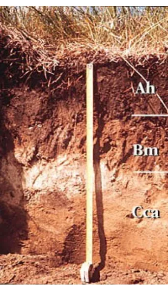
PROFIL DAN PEDON
Pedon
Tubuh tanah (Pedon) jika
dipotong tegak akan memperlihatkan suatu seri lapisan yang dinamakan horison, karena masing-masing horison sedikit banyak sejajar dengan
permukaan bumi (horizontal).
Jika diselidiki ternyata
masing-masing horizon mempunyai ciri morfologi, sifat-sifat kimia, fisik dan biologi yang khas. Profil tanah adalah urutan susunan horizon yang tampak dalam anatomi tubuh tanah.
Berikut ini gambar pedon dan
PROFIL TANAH
Profil tanah tebalnya berlainan mulai dari yang setipis selaput sampai setebal 10 meter. Pada umumnya tanah makin tipis mendekati kutub dan makin tebal mendekati katulistiwa.
Uraian profil tanah dimulai dengan menentukan letak batas horizon, mengukur tebalnya dan mengamati profil tanah secara keseluruhan. Pada dasarnya horizon tanah mempunya ciri-ciri yang juga dihasilkan oleh proses genesa tanah.
Masing-masing horizon dibedakan dari horizon yang di atas atau di bawahnya oleh ciri-ciri yang spesifik dan genetis yaitu warna tanah, tekstur tanah, struktur tanah, konsistensi tanah, karatan dan perakaran. Meskipun dalam menguraikan suatu profil tanah tidak mutlak perlu memberi nama masing-masing horizon, akan tetapi berdasrakan pengalaman ternyata bahwa manfaat uraian tanah
meningkat jika dilengkapi dengan pemberian simbol. Untuk menyingkat masing-masing horizon diberi simbol huruf besar O, A, B, C dan R.
PENCIRIAN MORFOLOGI
Suatu seri tanah meliputi suatu lahan dengan ukuran tiga dimensi.
Penyidikan profil tanah merupakan dasar determinasi seri/jenis tanah yang dapat menentukan sifat kemampuannya. Profil tanah yang diamati dan digunakan sebagai dasar determinasi harus mewakili seri tanah, oleh karena itu pemilihan tempatnya sangat menetukan hasil interpretasi sifat kemampuan seri tanah tersebut. Pedoman pemilihan tempat-tempat penggalian lubang profil harus:
benar-benar mewakili dalam arti dipilih pada lahan yang topografi,
keadaan ekologi, maupun pertumbuhan, sama dengan sebagian terbesar seri tanah ini
baru dalam arti belum dipengaruhi lingkungan luar jauh dari batas-batas seri tanah
mudah didatangi team pemeriksa survei tanah agar tidak sukar dicari
Di lapangan kita catat semua ciri-ciri morfologi profil tanah yang
tampak, baik yang membedakan horison-horison maupun yang tidak, terutama morfologi tanah yang mencirikan, baik yang penting maupun yag tampak sepele. Yang perlu diperhatikan diwaktu pengamatan di lapangan ialah : mencatat semua ciri dan gejala yang tampak dalam pengamatan dan menghindarkan segala pertimbangan yang dapat mempengaruhi pengamatan, oleh karena itu untuk membedakan satu sama lain masing-masing horison cukup diberi nomor berurutan tanpa memikirkan masuk horison mana dengan simbol apa. Makin lengkap catatan-catatan mengenai ciri-ciri morfologi makin banyak bahan untuk dipertimbangkan.
Setiap lapisan pada profil masing-masing seri tanah diambil contoh
FORMULIR DESKRIPSI PROFIL TANAH
Kabupaten: Single: Kompleks:
Kecamatan: Bentuk: Panjang:
Desa:
Tempat profil: Eksposisi: Tempat di lereng : Drainase
Klas:
Tinggi d.m. laut: Permukaan: Didalam: Cuaca S. :
K. : Pemeabilitas: Gley
Pertumbuhan: Air tanah: Lembab tanah: Keadaan batu: Besar
Kecil Penghanyutan/erosi Pengaruh manusia
Pemakaian tanah Catatan
FORMULIR DESKRIPSI PROFIL TANAH
No. RISPA
Nomor Pengirim
Nomor Lapisan
Simbol Lapisan
Dalam Lapisan
Batas Lapisan
Konsistensi
B L K B L K B L K B L K B L K
tlk lp lp tlk lp lp tlk lp lp tlk lp lp tlk lp lp alk sgb lb alk sgb lb alk sgb lb alk sgb lb alk sgb lb
lk gb akr lk gb akr lk gb akr lk gb akr lk gb akr slk tg kr slk tg kr slk tg kr slk tg kr slk tg kr tpl stg skr tpl stg skr tpl stg skr tpl stg skr tpl stg skr
pl pl pl pl pl
spl spl spl spl spl
Jumlah Karatan Bandingan Ukuran
s bi ba s bi ba s bi ba s bi ba s bi ba
b d p b d p b d p b d p b d p
h sd k h sd k h sd k h sd k h sd k
Perakaran halus: banyak/sedang/sedikit sampai …………..cm kasar: banyak/sedang/sedikit sampai... cm
Padas
Kandungan CaCO3
Bahan Organik
Isi lain-lain
Corak Istimewa
HORISON UTAMA
•
Horison tanah merupakan suatu lapisan tanah, terletak hampir
sejajar permukaan bumi, dengan watak-watak dikendalikan
oleh proses-proses pembentukannya. Horison tanah
merupakan tubuh nyata dan sub-bagian dari individu tanah,
yang meluas secara lateral sepanjang sumbu x dan y, secara
vertikal sepanjang sumbu z.
•
Setiap profil dari suatu jenis tanah memperlihatkan jumlah
dan susunan horison yang khas. Antara horison satu dan
horison lain pada suatu profil tanah dibatasi oleh suatu garis
atau batas horison. Batas rekaan ini dapat dikenali dari hasil
interpretasi sejumlah watak horison yang berdampingan.
•
Langkah dasar deskripsi horison tanah adalah : 1. menetapkan
garis batas horison , 2. menentukan letak horison dalam profil
dan 3. mendeskripsi watak batas horison.
0 Horison organik adalah lapisan
tanah yang sebagian besar
terdiri atas bahan organik, baik
masih segar maupun sudah
membusuk terbentuk paling
atas di atas horison mineral.
Sebagian batas kandungan
bahan organik horison ini ialah
30% atau lebih jika tanahnya
bertekstur lempung (clay) lebih
dari 50%, atau kadar bahan
organnik 20% lebih jika
A
A Horison mineral paling atas Horison mineral paling atas terdiri atas:terdiri atas:
► A1 A1 Horison mineralHorison mineral terbentuk paling terbentuk paling
atas yang menampakkan ciri-ciri atas yang menampakkan ciri-ciri
percampuran
percampuran erat mineral dan bahan erat mineral dan bahan organik.
organik. Partikel mineralnya diselaputi Partikel mineralnya diselaputi bahan organik atau bahan organik
bahan organik atau bahan organik
merupakan partikel tersendiri, sehingga merupakan partikel tersendiri, sehingga memberi warna hitam atau warna kelam memberi warna hitam atau warna kelam pada horison.
pada horison.
► A2 A2 Horison eluviasiHorison eluviasi yang menampakkan yang menampakkan
ciri terlindi (leaching) paling maksimal. ciri terlindi (leaching) paling maksimal. Karena kation, bahan organik, besi, Karena kation, bahan organik, besi, aluminium, dan atau basa lainnya yang aluminium, dan atau basa lainnya yang berwarna telah terlindi dan yang tertinggal berwarna telah terlindi dan yang tertinggal bahan-bahan resisten atau kuarsa yang kasar bahan-bahan resisten atau kuarsa yang kasar tidak berwarna, maka horison-horison ini
tidak berwarna, maka horison-horison ini bersifat warnanya paling cerah/muda atau bersifat warnanya paling cerah/muda atau paling pucat, tekstur paling kasar dan
paling pucat, tekstur paling kasar dan
struktur paling longgar dibandingkan dengan struktur paling longgar dibandingkan dengan horison lainnya.
► BB Horison mineral illuviasiHorison mineral illuviasi
mempunyai ciri dominan :1. akumulasi
mempunyai ciri dominan :1. akumulasi
basa, lempung, besi, aluminium dan
basa, lempung, besi, aluminium dan
atau bahan organik masing-masing
atau bahan organik masing-masing
sendiri atau bersama-sama yang terlindi
sendiri atau bersama-sama yang terlindi
dari horison A di atasnya; 2. konsentrasi
dari horison A di atasnya; 2. konsentrasi
residu sesquioxida atau dan lempung
residu sesquioxida atau dan lempung
yang terbentuk karena larutnya karbonat
yang terbentuk karena larutnya karbonat
atau garam-garam lain; atau 3.
atau garam-garam lain; atau 3.
perubahan (alterasi) bahan-bahan dari
perubahan (alterasi) bahan-bahan dari
keadaan asalnya dan terbentuknya
keadaan asalnya dan terbentuknya
struktur berbutir (granuler), gumpal
struktur berbutir (granuler), gumpal
(blocky), atau tiang (prismatic).
(blocky), atau tiang (prismatic).
► Ciri umum horison ini ialah warna lebih Ciri umum horison ini ialah warna lebih
kelam, tekstur lebih berat dan struktur
kelam, tekstur lebih berat dan struktur
lebih rapat jika dibandingkan dengan
lebih rapat jika dibandingkan dengan
horison-horison lainnya, terutama
horison-horison lainnya, terutama
dengan horison A di atasnya. Horison ini
dengan horison A di atasnya. Horison ini
terbagi lagi, yaitu:
terbagi lagi, yaitu:
► B1 B1 Horison peralihanHorison peralihan dengan dengan
horison A yang mempunyai warna dan
horison A yang mempunyai warna dan
ciri lebih mendekati warna dan ciri
ciri lebih mendekati warna dan ciri
horison B.
horison B.
► B2 B2 Horison yang paling maksimalHorison yang paling maksimal
menampakkan horison B, sehingga
menampakkan horison B, sehingga
warnanya paling kelam, tekstur paling
warnanya paling kelam, tekstur paling
berat dan struktur paling padat.
C
C
Horison mineral
Horison mineral
, bukan batuan,
, bukan batuan,
sembarang apakah sama ataupun
sembarang apakah sama ataupun
tidak sama dengan bahan induknya,
tidak sama dengan bahan induknya,
relatif kurang dipengaruhi proses
relatif kurang dipengaruhi proses
perkembangan tanah dan tidak
perkembangan tanah dan tidak
memperlihatkan ciri-ciri diagnostik
memperlihatkan ciri-ciri diagnostik
horison A atau B tetapi tersusun
horison A atau B tetapi tersusun
atas bahan-bahan yang telah diubah
atas bahan-bahan yang telah diubah
oleh : a. Pelapukan di luar dareah
oleh : a. Pelapukan di luar dareah
kegiatan bologi utama, b.
kegiatan bologi utama, b.
Pemadatan (cementasi) reversibel,
Pemadatan (cementasi) reversibel,
proses perapuhan, penambahan
proses perapuhan, penambahan
berat volume dan sifat-sifat lain
berat volume dan sifat-sifat lain
fragipan, c. Gleisasi (gleysasi), d.
fragipan, c. Gleisasi (gleysasi), d.
Penimbunan dan pemadatan
Penimbunan dan pemadatan
(akumulasi dan sementasi),
(akumulasi dan sementasi),
karbonat kapur atau Mg, atau juga
karbonat kapur atau Mg, atau juga
garam-garam lain yang larut atau e.
garam-garam lain yang larut atau e.
Pemadatan (cementasi) oleh bahan
Pemadatan (cementasi) oleh bahan
silikat alkali besi atau silika. Horison
silikat alkali besi atau silika. Horison
inin tidak terbagi lagi.
The New Subordinate Distinctions
The New Subordinate Distinctions
Within Master Horizons
Within Master Horizons
Lower case letters are used to
Lower case letters are used to
designate specific features within
designate specific features within
master horizons. They are listed in
master horizons. They are listed in
alphabetical order below:
alphabetical order below:
► a:a: Highly decomposed organic Highly decomposed organic
material. The 'a' is used only with
material. The 'a' is used only with
the O master
the O master horizon. The rubbed horizon. The rubbed fiber content < 17 % of the volume.
fiber content < 17 % of the volume.
b:
b: Buried genetic horizon. It is not Buried genetic horizon. It is not used in organic soils or to
used in organic soils or to
identify a buried O master
identify a buried O master
horizon.
horizon.
c:
c:
Concretions of hard
Concretions of hard
nonconcretionary nodules. This
nonconcretionary nodules. This
symbol is used only for iron,
symbol is used only for iron,
aluminium, manganese, or
aluminium, manganese, or
titanium cemented nodules or
titanium cemented nodules or
concretions.
concretions.
d:
d:
Physical root restriction. It is
Physical root restriction. It is
used to indicate naturally
used to indicate naturally
occuring or humanly
occuring or humanly
induced
induced
layers such as basal till, plow
layers such as basal till, plow
pans, and other mechanically
pans, and other mechanically
compacted
compacted
zones. Roots do
zones. Roots do
not enter except along fracture
not enter except along fracture
planes.
e:
e: Organic material of intermediate Organic material of intermediate
decomposition. This symbol is only used
decomposition. This symbol is only used
in combination with an O master horizon
in combination with an O master horizon
with rubbed fiber content between 17 -
with rubbed fiber content between 17 -
40 %
40 % of the volume of the volume
f:
f: Frozen soil. The horizon must Frozen soil. The horizon must contain permanent ice.
g:
g: Gleying: This symbol is used in B Gleying: This symbol is used in B and C horizons to indicate low
and C horizons to indicate low
chroma color (<= 2), caused by
chroma color (<= 2), caused by
reduction of iron in stagnant
reduction of iron in stagnant
saturated conditions. The iron may
saturated conditions. The iron may
or may not be present in the
or may not be present in the
ferrous form (Fe2+ ). The g is used
ferrous form (Fe2+ ). The g is used
to indicate either total
to indicate either total gleying or gleying or the presence of gleying in a mottled
the presence of gleying in a mottled
pattern. It is not used in E horizons,
pattern. It is not used in E horizons,
which are commonly of low chroma,
which are commonly of low chroma,
or in C horizons where the low
or in C horizons where the low
chroma colors are inherited form
chroma colors are inherited form
the parent material and no evidence
the parent material and no evidence
of saturation is apparent.
of saturation is apparent.
h:
h: Illuvial accumulation of organic Illuvial accumulation of organic matter: Used only in B horizons.
matter: Used only in B horizons.
The h indicates an accumulation of
The h indicates an accumulation of
illuvial, amorphous, dispersible
illuvial, amorphous, dispersible
organic matter with or without
organic matter with or without
sequioxide component. If the
sequioxide component. If the
sequioxide component contains
sequioxide component contains
enough iron so that the color value
enough iron so that the color value
and chroma exceed 3 additionally a
and chroma exceed 3 additionally a
s is used (hs).
s is used (hs).
The organosequioxide complexes
The organosequioxide complexes
may coat sand and silt particles, or
may coat sand and silt particles, or
occur as discrete pellets, or fill voids
occur as discrete pellets, or fill voids
and cement the horizon (use of m).
i:
i: Slightly decomposed organic Slightly decomposed organic
material. Used only in combination
material. Used only in combination
with an O master horizon to
with an O master horizon to
designate that the rubbed fiber
designate that the rubbed fiber
content is > 40 % of the volume.
content is > 40 % of the volume.
k:
k: Accumulation of carbonates, usually Accumulation of carbonates, usually calcium carbonate. Used with B and
calcium carbonate. Used with B and
C horizons.
m:
m: Cementation or induration: Cementation or induration: Used with any master horizon,
Used with any master horizon,
except R, where > 90 % of the
except R, where > 90 % of the
horizon is cemented and roots
horizon is cemented and roots
penetrate only through cracks. The
penetrate only through cracks. The
cementing
cementing material is identified material is identified by the appropriate letter:
by the appropriate letter:
n: Accumulation of sodium: This Accumulation of sodium: This symbol is used on any master
symbol is used on any master
horizon showing morphological
horizon showing morphological
properties indicative of high levels
properties indicative of high levels
of exchangeable sodium.
of exchangeable sodium.
o:
o: Residual accumulation of Residual accumulation of sesquioxides.
► p:p: Tillage or other cultivation Tillage or other cultivation
disturbance (e.g. plowing, hoeing,
disturbance (e.g. plowing, hoeing,
discing). This symbol
discing). This symbol is only used is only used in combination with the master
in combination with the master
horizon A or O.
horizon A or O.
► q:q: Accumulation of silica: This Accumulation of silica: This
symbol is used with any master
symbol is used with any master
horizon, except R, where secondary
horizon, except R, where secondary
silica has accumulated
silica has accumulated
► r: r: Weathered soft bedrock: This Weathered soft bedrock: This
symbol is only used in combination
symbol is only used in combination
with the master
with the master C horizon. It C horizon. It designates saprolite or dense till
designates saprolite or dense till
that is hard enough that roots only
that is hard enough that roots only
penetrate along cracks, but
penetrate along cracks, but
which is soft enough that it can be
which is soft enough that it can be
dug with a spade or
► s: s: Illuvial accumulation of Illuvial accumulation of
sesquioxides and organic matter.
sesquioxides and organic matter.
This symbol is only used in
This symbol is only used in
combination with B horizons. It
combination with B horizons. It
indicates the presence of illuvial
indicates the presence of illuvial
iron oxides. It
iron oxides. It is often used in is often used in
conjunction with h when the color is
conjunction with h when the color is
=< 3 (chroma and value).
=< 3 (chroma and value).
► ss: ss: Presence of slickensides. They Presence of slickensides. They
are formed by shear failure as clay
are formed by shear failure as clay
material swell
material swell upon wetting. Their upon wetting. Their presence is an indicator of vertic
presence is an indicator of vertic
characteristics.
► t:t: Accumulation of silicate clay: Accumulation of silicate clay:
The presence of silicate clay
The presence of silicate clay
forming coats on ped
forming coats on ped faces, in faces, in pores, or on bridges between
pores, or on bridges between
sand-sized material grains. The clay coats
sized material grains. The clay coats
may be either formed by illuviation
may be either formed by illuviation
or concentrated by migration within
or concentrated by migration within
the
the horizon. Usually used in horizon. Usually used in
combination with B horizons, but it
combination with B horizons, but it
may be used in C or R horizons
may be used in C or R horizons
also.
also.
► v:v: Plinthite: This symbol is used Plinthite: This symbol is used
in B and C horizons that are humus
in B and C horizons that are humus
poor and iron
poor and iron rich. The material rich. The material usually has reticulate mottling of
usually has reticulate mottling of
reds, yellows, and gray colors.
reds, yellows, and gray colors. ► w:w: Development of color and Development of color and
structure. This symbol is used for B
structure. This symbol is used for B
horizons that have
horizons that have developed developed structure or color different, usually
structure or color different, usually
redder than that of the A or C
redder than that of the A or C
horizons, but do not have apparent
horizons, but do not have apparent
illuvial accumulations.
► x:x: Fragipan character: This Fragipan character: This
symbol is used to designate
symbol is used to designate
genetically developed
genetically developed firmness, firmness, brittleness, or high bulk density in B
brittleness, or high bulk density in B
or C horizons. No cementing agent
or C horizons. No cementing agent
is evident.
is evident.
► y: y: Accumulation of gypsum. This Accumulation of gypsum. This
symbol is used in B and C horizons
symbol is used in B and C horizons
to indicated
to indicated genetically genetically accumulated gypsum.
accumulated gypsum.
► z: z: Accumulation of salts more Accumulation of salts more
soluble than gypsum. This symbol is
soluble than gypsum. This symbol is
used in
used in combination with B combination with B and C horizons.
Role of The Laboratoroy And The Compositonal Data It Provides
Role of The Laboratoroy And The Compositonal Data It Provides
►
To make precise differentiation among soils groups, it has become
To make precise differentiation among soils groups, it has become
necessary to rely on laboratory measurements of selected soil
necessary to rely on laboratory measurements of selected soil
properties. For example, to make a distinction between the more highly
properties. For example, to make a distinction between the more highly
weathered soils of the tropical region and those in tropical and other
weathered soils of the tropical region and those in tropical and other
areas which are less weathered and developed, it is necessary to
areas which are less weathered and developed, it is necessary to
obtain information about the chemical properties of these kinds of soils.
obtain information about the chemical properties of these kinds of soils.
The most helpful type information in this case includes measurement of
The most helpful type information in this case includes measurement of
the “free” or extractable iron component, the cation exchange capacity,
the “free” or extractable iron component, the cation exchange capacity,
and the content of weatherable minerals.
and the content of weatherable minerals.
►
Thus modern soil classification systems place a great deal of reliance on
Thus modern soil classification systems place a great deal of reliance on
information about the quantitative compositions of soils. Certain kinds
information about the quantitative compositions of soils. Certain kinds
of soil properties are selected for use in the classification process,
of soil properties are selected for use in the classification process,
based on their assumed importance in understanding the genesis of the
based on their assumed importance in understanding the genesis of the
soil and on the number of other important properties which co-vary
soil and on the number of other important properties which co-vary
with changes in the property under consideration. Analytical methods
with changes in the property under consideration. Analytical methods
are selected which offer the best means of measuring the
are selected which offer the best means of measuring the
compositional properties of interest.
ANALISIS
SIFAT FISIK
BULK DENSITY
MINERALOGI
SIFAT KIMIA
SKELETAL MINERALOGY
CLAY MINERALOGI CEC
EXCHANGEABLE BASES
pHw
Fe BEBAS
BASE SATURATION
C & N
EXCHANGEABLE Al & H
PARTICLE SIZE
SOIL MOISTURE
ROCK
PARENT MATERIAL
HORISON A
Bw
HORISON B
Bt
SOIL MICROMORPHOLOGY
Soil micromorphology can be viewed simply as the study of
Soil micromorphology can be viewed simply as the study of
soiol morphology in the size range where optical aid is
soiol morphology in the size range where optical aid is
needed for the naked eye. The lower limit of resolution of
needed for the naked eye. The lower limit of resolution of
the unaided eye is in the range of objects 100 to 200 micro
the unaided eye is in the range of objects 100 to 200 micro
in diameter.
in diameter.
S-matrix is the material within the simplest (primary) peds, or
S-matrix is the material within the simplest (primary) peds, or
composing apedal soil materials, in which the pedological
composing apedal soil materials, in which the pedological
features occur; it consists of the plasma, skeleton grains,
features occur; it consists of the plasma, skeleton grains,
and voids that do not occur in pedological features other
and voids that do not occur in pedological features other
than plasma separations.
than plasma separations.
DEFINITION
KOMPONEN MIKROMORFOLOGI TANAH
PEDOLOGICAL FEATURES
On grain and peds
SPHERICAL UNIT
GLACBULES CHANNEL FILLING
DOMAIN OF CLAY IN PLASMIE
PLASMA SEPARATION VOID
PLANAR VOID OR PLANES
UNSTABLE &
MOBILE TABULAR
SKELETON GRAIN
LINEAR
PLASMA
ORGANIC
KLASIFIKASI TANAH
USDA 1938 FAO INDONESIA
1st-7th Approximation
ST 1995, 11 ORDO ST 1975,10 ORDO
CARA DETERMINASI
ST, 1998 12 ORDO
-ENTISOLS
-LATERIT Merah
Kuning
-LATOSOL -BROWN
FOREST SOIL
-MEDITERAN
MERAH KUNING
-NON CALCIC
BROWN SOIL
-GLEY HUMIK -GLEY HUMIK
RENDAH
-PLANOSOL -PODSOL AIR
TANAH
-HIDROMORFIK
KELABU
-LATERIT AIR
-
ORGANOSOL
-LITOSOL
-
ALUVIAL
-REGOSOL
-GRUMUSOL
-RENDZINA
-PODZOL
-ANDOSOL
-
PODSOLIK Merah Kuning
-LATERIT Merah Kuning
-
LATOSOL
-
BROWN FOREST SOIL
-
MEDITERAN MERAH KUNING
-NON CALCIC BROWN SOIL
-GLEY HUMIK
-
GLEY HUMIK RENDAH
-PLANOSOL
-
PODSOL AIR TANAH
-HIDROMORFIK KELABU
-LATERIT AIR TANAH
HORISON PENCIRI
HORISON PENCIRI
(DIAGNOSTIC HORIZONS)
(DIAGNOSTIC HORIZONS)
HORISON ATAS PENCIRI (EPIPEDON)
The epipedon is a diagnostic surface horizon.
The epipedon is a diagnostic surface horizon.
It includes :
It includes :
► the upper part of the soil darkened by organic matter (mostly A1,Ap)the upper part of the soil darkened by organic matter (mostly A1,Ap) ► the upper eluvialhorizon (mostly A2,A3)the upper eluvialhorizon (mostly A2,A3)
Remarks
Remarks
► Epipedon is not a synonym for A horizons, because it may include part or all Epipedon is not a synonym for A horizons, because it may include part or all
of the B horizons, if the organic matter extends from the A into the B.
of the B horizons, if the organic matter extends from the A into the B.
► Recent alluvial, colluvial, or eolin deposits, that are finely stratified, are not Recent alluvial, colluvial, or eolin deposits, that are finely stratified, are not
included in the concept of epipedon, because pedogenetic features are not
included in the concept of epipedon, because pedogenetic features are not
sufficiently developed
sufficiently developed
► An Ap hor. , overlying the above mentioned materialsis also not an An Ap hor. , overlying the above mentioned materialsis also not an
epipedon
epipedon
► In virgin soils the properties of the epipedon should be determined after the In virgin soils the properties of the epipedon should be determined after the
surface 18 cm have been mixed; this is to avoid changes in classification of
surface 18 cm have been mixed; this is to avoid changes in classification of
a soil as the result of plowing
a soil as the result of plowing
EPIPEDON
JENIS-JENIS EPIPEDON:
JENIS-JENIS EPIPEDON:
1.
1.
ANTHROPIC
ANTHROPIC
2.
2.
FOLISTIC
FOLISTIC
3.
3.
HISTIC
HISTIC
4.
4.
MELANIC
MELANIC
5.
5.
MOLLIC
MOLLIC
6.
6.
OCHRIC
OCHRIC
7.
7.
PLAGGEN
PLAGGEN
8.
8.
UMBRIC
UMBRIC
CONTOH:
JENIS-JENIS HBP:
JENIS-JENIS HBP:
1.
1.
AGRIC
AGRIC
2.
2.
ALBIC
ALBIC
3.
3.
ARGILLIC
ARGILLIC
4.
4.
CALCIC
CALCIC
5.
5.
CAMBIC
CAMBIC
6.
6.
DURIPAN
DURIPAN
7.
7.
FRAGIPAN
FRAGIPAN
8.
8.
GLOSSIC
GLOSSIC
9.
9.
GYPSIC
GYPSIC
10.
10.
KANDIC
KANDIC
11.
11.
NATRIC
NATRIC
12.
12.
ORSTEIN
ORSTEIN
13.
13.
OXIC
OXIC
14.
14.
PETROCALCIC
PETROCALCIC
15.
15.
PETROGYPSIC
PETROGYPSIC
16.
16.
PLACIC
PLACIC
17.
17.
SALIC
SALIC
18.
18.
SOMBRIC
SOMBRIC
19.
19.
SPODIC
SPODIC
CONTOH : AGRIC
ACUAN GENESIS TANAH
CONCEPT METHOD
THE PRESENT IS THE KEY TO THE PAST
SOIL OF THE EATH ARE NATURAL “CLAY FACTORIES”
PODZOLIZATION
LATERIZATION
EVOLUTION OF EARTS MUST HAVE RESULTED IN A SUCESSION
OF SOILS ON A GRAND TIME SCALE
A KNOWLEDGE OF PALEOCOLOGY
(AS FAR BACK AS ONE OR TWO MILLION YEARS BEFORE)
UNIQUE TO SOIL GENESIS
COMPLEXING OF MINERAL AND ORGANIC MATERIALS
DEPENDENT VARIABLE INDEPENDENT VARIABLE
MACROANALYSIS
ANALISIS SIFAT TANAH DI LAB UNTUK GENESIS & TAKSONOMI
GENESIS TAKSONOMI
ANALYSIS TOTAL PENYUSUN MINERAL
BULK DENSITY CEC
LINIER EXTENSIBILITY
PARTICLE SIZE (PIPET METHOD)
FABRIC RELATED ION EXCHANGE
WATER RETENTION
EXTRACTABLE BASES MICROMORPHOLOGY
(THIN SECTION
SODIUM ADSORPTION RATIO SODIUM SATURATION
CHEMICAL, X-RAY EMISSION, SPECTROGRAPHY
OPTICAL
INSTRUMENTAL
PREPARATION, XRD, DTA
1. ABRUPT TEXTURAL CHANGE
1. ABRUPT TEXTURAL CHANGE
2. ALBIC MATERIAL
2. ALBIC MATERIAL
8. IDENTIFIABLE SECONDARY
8. IDENTIFIABLE SECONDARY
CARBONATES
CARBONATES
11. LINEAR EXTENSIBILITY
11. LINEAR EXTENSIBILITY
10.LAMELLAE
10.LAMELLAE
9. INTERFINGERING OF
9. INTERFINGERING OF
ALBIC MATERIAL
ALBIC MATERIAL
7. FRAGIC SOIL PROPERTIES
7. FRAGIC SOIL PROPERTIES
6. DURIDONODES
6. DURIDONODES
5. COEFFICIENT OF LINEAR
5. COEFFICIENT OF LINEAR
EXTENSIBILITY (COLE)
EXTENSIBILITY (COLE)
4. ANHYDROUS CONDITIONS
4. ANHYDROUS CONDITIONS
12. LITHOLOGIC
12. LITHOLOGIC
DISCONTINUITES
DISCONTINUITES
3. ANDIC SOIL PROPERTIES
13. N VALUE
16. RESISTANT MINERAL
16. RESISTANT MINERAL
17. SLICHEN SIDE
17. SLICHEN SIDE
18. SPODIC MATERIALS
18. SPODIC MATERIALS
19.WEATHERABLE MINERALS
19.WEATHERABLE MINERALS
20. FIBERS
20. FIBERS
21. FIBRES SOIL MATERIALS
21. FIBRES SOIL MATERIALS
22. HEMIC SOIL MATERIALS
22. HEMIC SOIL MATERIALS
23. SAPRIC SOIL MATERIALS
23. SAPRIC SOIL MATERIALS
24. HUMILUVIC MATERIAL
24. HUMILUVIC MATERIAL
25. LIMNIC
SEJARAH, KATEGORI, TATANAMA
FIRST APPROXIMATION TO 7TH APPROXIMATION
SOIL TAXONOMY, 1975 10 ORDO
SOIL TAXONOMY, 1995 11 ORDO
KATEGORI
ORDER
SUBORDER
GREAT GROUP
SUBGROUP
FAMILY
ORDO-ORDO TANAH
1.
ALFISOL
Typic Hapludalf
Michigan Selatan
Ordo : Alfisol
Sub-ordo
: Udalf
Great Group
: Hapludalf
Sub-Group
: Typic Hapludalf
Tanah ini terbentuk di daerah
aliran sungai es yang poreus
sampai pada lahan bergunung.
Tumbuhan setempat seperti
huatan kayu keras dan umunya
digunakan untuk tumbuhan pohon
(beech) dan sugar maple.
2. ANDISOL
ashy over sandy-skeletal, aniso,
glassy over isotic, frigid Typic
Vitrixerand
(Seri Bonner)
Ordo : Andisol
SO
: Xerand
GG
: Vitrixerand
SG
:Typic Vitrixerant
Tanah ini terbentuk pada 2 bahan
induk dan bentuk khas (typic)
banyak terdapat di Idaho utara,
Washington Timur dan Montana
Barat. Pada kedalaman 35-60 cm
terdiri atas 60% debu volkan,
3.ARIDISOL
coarse-silty, mixed, superactive, mesic Xeric Haplocalcid
(Seri Owyhee)
Ordo : Aridisol SO : Calcid
GG : Haplocalcid
SG : Xeric haplocalcid
Struktur lempeng pada horizon C mengindikasikan bahwa endapan
Lacustrin adalah bahan induk tanah ini. Perkembangan tanah berlangsung lambat pada iklim kering dan CaCO3 adalah warisan dari bahan induk yang perlahan tercuci dari profil tanah.
Bilamana tanah bawah mengandung CaCO3 yang terakumulasi, membuat seluruh profil alkalis.
Pencucian yang cukup membentuk horizon Bw dengan struktur gumpal dan warna lebih terang. Pada saat ini karbonat bergerak lebih ke bawah dan translokasi liat di bagian atas dimulai.