Study of Lessons Learned
from Mangrove/Coastal Ecosystem
Restoration Efforts in Aceh
Study of Lessons Learned
from Mangrove/Coastal Ecosystem
Restoration Efforts in Aceh since
the Tsunami
By:
Iwan Tri Cahyo Wibisono
I Nyoman Suryadiputra
Indonesia Programme
Study of Lessons Learned
from Mangrove/Coastal Ecosystem Restoration Efforts in Aceh
since the Tsunami
© Wetlands International – Indonesia Programme, 2006
Authors : Iwan Tri Cahyo Wibisono
I Nyoman N. Suryadiputra
Graphic Design : Triana
Cover Photographs : Doc. Wetlands International – IP
This report is available in:
Wetlands International – Indonesia Programme Jl. A.. Yani No. 53 Bogor 16161
Jawa Barat – INDONESIA Tel. 0251 312189
Fax. 0251 325755
E-mail: [email protected]
Reference:
Wibisono, I.T.C. and I Nyoman N. Suryadiputra. 2006. Study of Lessons Learned from Mangrove/Coastal Ecosystem Restoration Efforts in Aceh since the Tsunami. Wetlands International – Indonesia Programme. Bogor. xiii + 86.
“The opinions indicated in this publication should not necessarily be considered as
reflecting the views or carrying the endorsement of the United Nations
Environment Programme”
Study of Lessons Learned
from Mangrove/Coastal Ecosystem
Restoration Efforts in Aceh since
the Tsunami
By:
Iwan Tri Cahyo Wibisono
I Nyoman N. Suryadiputra
Indonesia Programme
Study of Lessons Learned
from Mangrove/Coastal Ecosystem Restoration Efforts in Aceh
since the Tsunami
© Wetlands International – Indonesia Programme, 2006
Authors : Iwan Tri Cahyo Wibisono I Nyoman N. Suryadiputra Translated by : Wendy Suryadiputra Design and Lay-out : Triana
Cover Photographs : Doc. Wetlands International – IP
This report is available in:
Wetlands International – Indonesia Programme Jl. A.. Yani No. 53 Bogor 16161
Jawa Barat – INDONESIA Tel. 0251 312189 Fax. 0251 325755 E-mail: [email protected]
Reference:
Wibisono, I.T.C. and I Nyoman N. Suryadiputra. 2006. Study of Lessons Learned from Mangrove/Coastal Ecosystem Restoration Efforts in Aceh since the Tsunami. Wetlands International – Indonesia Programme. Bogor. xiii + 83.
“The opinions indicated in this publication should not necessarily be considered as
reflecting the views or carrying the endorsement of the United Nations
Introduction
The Tsunami disaster on Dec 26, 2004 swept along 800 km of NAD province’s coast, causing the death and loss of 167 thousand people. Around 500 thousand people lost their homes and livelihoods.
Up to December 2005, as many as 124 international NGOs, 430 national NGOs, dozens of donor and UN organizations, a variety of Government institutions and military institutions had been recorded, together with the community, to be working on rebuilding Aceh (BRR,2005).
The first step in the reconstruction effort focused mostly on the emergency response, particularly with regard to fulfilling the victims’ need for basic items such as food, clean water and shelter. As conditions in the field began to improve, the emergency gradually subsided and work moved on to the next phase, rehabilitation. From that point on, attention began to be directed towards restoration of the environment, particularly in those areas hit by the Tsunami. A number of organizations, both government and non-government, initiated a variety of environmental restoration activities, in particular the planting of mangrove and other coastal vegetation in an effort to restore the coastlands. Within only a couple of months, coastal rehabilitation actions had mushroomed throughout the Aceh coast. And the hitherto unknown term ‘mangrove’ suddenly become familiar in the community, who had previously called it by its local name “bak bangka”.
After 1.5 years of coastal rehabilitation activity, the results are now clear. Only a small fraction of it has been successful, the rest has failed. This can be seen simply from the low survival rate of plants in the field. Reasons given for the failures include: mistakes in the selection of planting sites, unsuitable choice of plants, insufficient preparation, inadequate guidance, no tending of the plants, and the low capacity of human resources.
Another weakness found in the field was the very limited amount of community involvement in the rehabilitation activity. Communities tended to be included only as workers, not as partners involved actively and continuously. Moreover, coordination and information sharing among the stakeholders concerned with the rehabilitation activity were very poor.
A mistaken perception among the implementers was that rehabilitation activity ended once the seedlings had been planted in the field. The result as they saw it, therefore, was the number of seedlings planted, not the number that survived after planting.
Apart from the matters mentioned above, the coastal rehabilitation activities underway in NAD province have provided a great many experiences and valuable lessons. Sadly, these escaped the attention of the stakeholders in Aceh, who therefore failed to learn anything from them. For this reason, Wetlands International-Indonesia Programme collaborated with UNEP to undertake this Study of Lessons Learned from Mangrove/Coastal Ecosystem Restoration Efforts in Aceh since the Tsunami.
Glossary and Abbreviations
ADB Asian Development Bank
Bappeda Badan Perencanaan dan Pembangunan Daerah(Regional planning board)
Bappenas Badan Perencanaan dan Pembangunan Nasional (National planing board)
Bapedalda Badan Pengendalian Dampak Lingkungan Daerah
BRR Badan Rehabilitasi dan Rekonstruksi
BKSDA Balai Konservasi Sumber Daya Alam (Natural Resources Conservation Agency)
BP-DAS Balai Pengelola Daerah Aliran Sungai (Watershed management authority)
CBO Community Based Organization
CITES Convention on International Trade in Endangered Species of Wild flora and fauna
CII Care International Indonesia
CPSG Campus Professional Scientific Group (LSM yang beranggotakan staff pengajar muda dan mahasiswa UNSYAH)
Dishut Dinas Kehutanan (Forestry office)
Disbunhut Dinas Kehutanan dan Perkebunan (Forestry and plantation office)
Dishutbuntran Dinas Kehutanan, Perkebunan dan Transmigrasi (Forestry, plantation and resettlement office)
Dispertanhutbun Dinas Pertanian, Kehutanan dan Perkebunan (Agriculture, forestry and plantation office)
DKP Dinas Kelautan dan Perikanan (Marine and Fishery office)
dpl di atas permukaan laut (above sea level)
ETM Enhanced Thematic Mapper. Suatu system dalam pencitraan yang dimiliki oleh satelit Landsat.
FAO Food and Agriculture Organization
GCRP Green Coast Recovery Project, securing the future of nature and people after the tsunami. Atau disingkat Green Coast for Nature and People after the tsunami atau Green Coast. Proyek ini didanai oleh Novib (Oxfam) Netherlands dan di Indonesia dilaksanakan oleh WI-IP dan WWF
GNRHL Gerakan Nasional Rehabilitasi Hutan dan Lahan (National Movement of land/forest rehabilitation)
INTAG Inventarisasi dan Tata Guna Hutan. Salah satu direktorat jenderal di Departemen Kehutanan yang menangani kegiatan-kegiatan yang terkait dengan perpetaan, inventarisasi dan tata guna lahan. Saat ini, institusi inil telah berubah nama menjadi BAPLAN (Badan Planologi Kehutanan).
IOM International Organization for Migration
IPB Institut Pertanian Bogor
ITTO International Timber Trade Organization
IUCN International Union for the Conservation of Nature and Natural Resources
Kab. Kabupaten
Kades Kepala Desa
Kapet Kawasan Ekonomi Terpadu
Kec. Kecamatan
KK Kepala Keluarga
KMS Koalisi Masyarakat Sipil
KSM Kelompok Swadaya Masyarakat (CBO – Community Based Organization)
LAPAN Lembaga Antariksa dan Penerbangan Nasional
LREP Land Resources Evaluation and Planning Project
LSM Lembaga Swadaya Masyarakat
NAD Nangroe Aceh Darussalam
NGO Non Government Organization
PBB Perserikatan Bangsa-bangsa
PEMDA Pemerintah Daerah
Puslitanak Pusat Penelitian Tanah dan Agroklimat (sekarang namanya diganti menjadi Balai Besar Litbang Sumberdaya Lahan Pertanian)
Prop. Propinsi
Ramsar Konvensi Internasional tentang Lahan Basah
RePPProT Regional Physical Planning Project For Transmigration
Satker Satuan kerja
SDM Sumber daya manusia
SPT Satuan Peta Tanah
Subsidence Suatu proses turunnya permukaan tanah (ambeles)
Tk I Tingkat I (Propinsi)
Tk II Tingkat II (Kabupaten)
UKM Unit Kegiatan Mahasiswa
UNEP United Nation Environment Programme
UNSYIAH Universitas Syiahkuala
TPI Tempat Pendaratan Ikan
WALHI Wahana Lingkungan Hidup
WI-IP Wetlands International – Indonesia Programme
WWF-I Yayasan World Wide Fund for Nature Indonesia
YPK Yayasan Pengembangan Kawasan
Contents
Page
INTRODUCTION...iii
GLOSSARY & ABBREVIATIONS ...iv
CONTENTS...v
LIST OF TABLE...xi
LIST OF BOXES ...xii
LIST OF PICTURES... xiii
1. PREFACE ...1
1.1. GENERAL PROFILE OF NAD PROVINCE ...1
1.1.1. Position and Size ... 1
1.1.2. Demography and Population ... 2
1.1.3. Climate... 2
1.2. LAND COVER CONDITION ...2
1.2.1. Condition of cover in 1999-2000 ...2
1.2.2. Condition of cover in 2002-2003 ...4
2. COASTAL CONDITION BEFORE THE TSUNAMI...6
2.1. MANGROVE FOREST ...6
2.1.1. Condition of mangrove vegetation and a history of its utilization ...6
2.1.2. Distribution and extent of mangrove in NAD province ...8
2.2. BEACH FOREST ...11
2.2.1. Distribution and extent of forest in NAD province ...11
2.3. AQUACULTURE PONDS ...12
2.4. PEATLAND ...13
2.5. SWAMP ...15
2.6. SANDY BEACH VEGETATION ...16
2.6.1. Pes-caprae formation ...16
2.6.2. Barringtonia Formation ...16
3. COASTAL CONDITION AFTER TSUNAMI...17
3.1 IMPACT OF THE TSUNAMI AND EARTHQUAKE ON ACEH’S COAST ...17
3.1.1. Changes to the coastal landscape of Aceh, Simeulue island and Nias island ...17
3.1.2. Degradation of mangrove forest ...20
3.1.3. Degradation of aquaculture ponds...25
3.1.4. Degradation of Peatland ...28
3.1.5. Degradation of swamp...28
3.1.6. Degradation of coastal vegetation...30
3.1.7. The formation of lagoon ecosystems as a result of the Tsunami (case study at Pulot village, Leupung sub-district, Aceh Besar) ...32
3.2. REGENERATION AND PRESENT CONDITION OF VEGETATION ...33
3.2.1 Regeneration of mangrove ...33
3.2.2 Regeneration of coastal vegetation ...34
3.3. PROSPECTS FOR REHABILITATION IN SEVERAL LOCATIONS ...36
3.3.1. Locations with good prospects for rehabilitation ...36
4. LESSONS LEARNED...39
4.1. THE ACTORS AND THEIR ROLES IN COASTAL REHABILITATION ... 39
4.1.1. Government ... 40
4.1.2. International Non Government Organizations (NGOs) ... 41
4.1.3. National NGOs ... 41
4.1.4. Private enterprise ... 41
4.1.5. Community ... 42
4.1.6. Community Based Organizations (CBO) ... 44
4.2. THE IMPLEMENTATION AND PROGRESS OF REHABILITATION ... 44
4.3. LEVEL OF SUCCESS ... 53
4.4 LIMITATIONS AND CONSTRAINTS IN THE FIELD ... 53
4.4.1. No blueprint for coastal rehabilitation has yet been provided ... 54
4.4.2. Most NGOs see coastal rehabilitation as a secondary activity ... 54
4.4.3. The lack of preparation ... 55
4.4.4. Failure in the nurseries ... 55
4.4.5. Planting in unsuitable locations ... 58
4.4.6. Problems concerning land ownership status of planting site ... 60
4.4.7. Pressure from the community on the donor to perform activities contrary to rehabilitation (Case study of Lham Ujong & Lham Dingin)... 61
4.4.8. Road construction from Banda Aceh to Meulaboh could clash with coastal rehabilitation program... 65
4.4.9. Aquaculture pond rehabilitation without mangrove ... 65
4.4.10. Rehabilitation using a project approach ... 66
4.4.11. Technical errors and mistakes in the field ... 67
4.4.12. Conflict of Interest ... 67
4.4.13. Pests ... 68
4.4.14. Lack of replacement planting and seedling maintenance ... 70
4.4.16. Poor coordination among stakeholders ...71
4.4.17. Inadequate spatial planning ...72
4.4.18. Lack of environmental awareness ...72
4.5. RECOMMENDATIONS ...73
4.5.1. Selection of appropriate species and planting sites ...74
4.5.2. Use of biological indicators when selecting planting site ...75
4.5.3. Development of Decision Supporting System for rehabilitation site selection ...76
4.5.4. Improvement of active community participation ...77
4.5.5. Capacity building through provision of technical manuals and training ...77
4.5.6. Development of silvo-fishery ...78
4.5.7. mproving coordination among stakeholders ...78
4.5.8. The need for sustained tending, monitoring and evaluation ...78
4.5.9. The need for mangrove enrichment ...79
4.5.10. Planting from the back of the beach towards the front ...79
4.5.11. Improvement of awareness raising ...80
4.5.12. Development of an “Exit strategy” to follow the completion of the rehabilitation and reconstruction program ...82
LIST OF TABLE
Table 2-1. Extent of mangrove forest in Aceh Province before the Tsunami ...9
Table 2-2. Total area of aquaculture ponds for each district/town in NAD Province ... 13
Table 3-1. Area of mangrove forest damaged by Tsunami in NAD province... 21
Table 3-2. Area of aquaculture ponds damaged by the Tsunami ... 25
Table 3-3. Area of swamp damaged by Tsunami... 28
Table 3-4. Area of forest, shrubland, plantation and open land affected by Tsunami (Ha)... 30
Table 3-5. Species of vegetation commonly found in shrublands... 35
Table 4-1. Data on plans for or realization of mangrove planting conducted by Government agencies ... 46
Table 4-2. Data on plans for or realization of mangrove planting conducted by NGOs ... 48
Table 4-3. Data on plans for or realization of planting of coastal vegetation by Government agencies and NGOs ... 49
Table 4-4. Characteristics of seed maturity for mangrove and coastal species ... 56
Table 4-5. Tsunami damage to aquaculture ponds in Aceh (source: Fisheries and Marine Affairs Department, 2005) ... 65
LIST OF BOXES
Box 2-1. Mangrove’s function in protecting the coast...7
Box 2-2. Green belt policy and spatial planning ...10
Box 2-3. Biodiversity in Beach Forest, Pulot village – Aceh Besar ...12
Box 3-1. The status and management of new and lost land (resulting from landscape
change)...20
Box 3-2. The impact of Tsunami deposits on the environment’s carrying capacity
(Case study in Lham Ujong village) ...27
Box 3-3. Natural regeneration; the threats and recommendations for better
management ...36
Box 4.1. Cash for work in rehabilitation activities...43
Box 4.2. Excerpts from press reports on Coastal Rehabilitation (translated from the
Indonesian) ...52
Box 4.3. SEA WALL IN LHAM DINGIN...62
LIST OF PICTURES
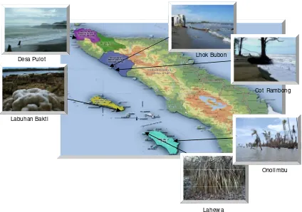
Figure 1-1. Map of NAD Province ...1
Figure 1-2. Land cover conditions for NAD province, based on interpretation of Landsat imagery 1999-2000 (Department of Forestry, 2002) ...3
Figure 1-3. Land cover conditions for NAD province, based on interpretation of Landsat imagery 2002-2003 (Department of Forestry, 2005) ...4
Figure 2-1. Scyphiphora hydrophyllacea, Ceriops decandra, Bruguiera gymnorrhiza, and Lumnitzera littorea (left to right) ...7
Figure 2-2. Map of Mangrove Distribution in NAD Province (Landsat image, 2000) ...13
Figure 2-3. Changes to the extent of forest cover in NAD Province ...11
Figure 2-4. Map of peatland distribution in NAD Province (WIIP, 2005) ...14
Figure 2-5. Degradation of peatlands (Cot Rambong village, Nagan Raya) ...15
Figure 3-1. Landscape change caused by earthquake and Tsunami along Aceh coast ...18
Figure 3-2. Loss of land as a result of earthquake and Tsunami (Lhok Bubon, Aceh Barat) ...19
Figure 3-3. Impact of uplifting of substrate: coral reef exposed and dying in Labuhan Bhakti-Simeulue, emergence of new land in Alus-alus-Simeulue, and dried, dead mangrove in Lahewa, Nias (clockwise)...19
Figure 3-4. Mangrove forest destroyed by Tsunami in Tibang – Aceh Besar ...20
Figure 3-5. Surviving young mangrove stand belonging to the community ...22
Figure 3-6. Mangrove which has desiccated due to uplifting of the substrate at Lahewa village, Nias...23
Figure 3-7. Invasion of mangrove stand floor by pioneer species of vegetation ...23
Figure 3-8. Illustration of mangrove death caused by lifting of the substrate at Lahewa-Nias...24
Figure 3-9. Tsunami deposits on pond floor ...26
Figure 3-10. Condition of aquaculture ponds at Lham Ujong before (top) and after (bottom) the Tsunami ...26
Figure 3-12. Condition of swamp before and after the Tsunami, at Lhok Bubon-Aceh
Barat ...29
Figure 3-13. Damage to coastal zone of West Aceh, caused by Tsunami...30
Figure 3-14. Impact of Tsunami: coconut tree (left) and pine (right) broken, swept by the Tsunami at Lhok Nga-Aceh Besar ...31
Figure 3-15. Effect of sea water: Breadfruit tree alive and healthy (left), Mangosteen tree dead as a result of sea water inundation (right) ...31
Figure 3-16. Lagoon at Pulot village, formed by the Tsunami...32
Figure 3-17. Mangrove habitat so badly devastated that mangrove can not recover ...34
Figure 3-18. Regeneraton of mangrove in Lamsenia village, Aceh Besar ...34
Figure 3-19. Shrublands formed 1.5 years after the Tsunami...35
Figure 3-20. Condition of young Casuarina stand in Lhok Nga, Aceh Besar...36
Figure 3-21. Suitable locations for mangrove; pond dykes (left) and river estuary (right)...37
Figure 3-22. Pes-caprae formation on sandy beach suitable for planting activities ...37
Figure 3-23. Locations where rehabilitation should be avoided ...38
Figure 4.1. Flowchart showing the mechanisms for rehabilitation activities ...40
Figure 4.2. Various species of coastal vegetation: sea pine, hibiscus, pandanus, cerbera and tamarind (clockwise from top left) ...45
Figure 4.3. Rough calculation of the total area rehabilitated and number of seedlings planted (based on data compiled from various sources) ...46
Figure 4.4. Nurseries sited in unsuitable areas: site subject to heavy inundation and strong currents (left); site not subject to inundation (right). Both failed totally. Photographs taken in Lham Nga - Aceh Besar ...57
Figure 4.5. Nursery failure due to mistakes in choice of media ...57
Figure 4.6. Mangrove planted on sandy beach ...58
Figure 4.7. Mangrove planted on permanently dry mud ...59
Figure 4.8. Planting on open sandy beach...59
Figure 4.9. Coastal species planted on inundated land ...60
Figure 4.11. One hypothesis of the potential flooding that could result in Lham
Dingin (where land sunk after the tsunami), if a sea wall is constructed ...63
Figure 4.12. Lham Dingin flooded with sea and river water Photograph WI-IP 11 & 17 September 2005) ...64
Figure 4.13. (Top) Pond dykes and land (empty land in centre) where mangrove could be planted (these ponds are in Ceunamprong and Kareng Ateuh villages in Jaya subdistrict of Aceh Jaya district, and have been rehabilitated by BRR). (Bottom left) One of these ponds has become a slough for buffalo to wallow. (Bottom right) Pond on Lhoong coast in danger of abrasion. Mangrove therefore needs to be planted along the shore in front. ...66
Figure 4.14. Seedlings taken out of the polybags to make work easier ...67
Figure 4.15. Mangroves fall victim to rehabilitation of ponds ...68
Figure 4.16. Molluscs attacking mangrove ...68
Figure 4.17. Coconut palms devastated by wild boar attack ...69
Figure 4.18. Various types of fence to protect seedlings ...70
Figure 4.19. Broken, useless and abandoned fences in Lhok Nga ...70
Figure 4.20. Fence swallowed by climbing plants, and seedling eventually dies ...71
Figure 4.21. Biological indicators of planting sites for mangrove and coastal vegetation: Ipomea pes-caprae (left) and Mud skipper (right) ...75
Figure 4.22. Molluscs/barnacle ; a biological indicator of sites to be avoided...76
Figure 4.23. DSS flow chart for selecting a rehabilitation site ...76
Figure 4.24. A recommended silvo-fishery system: planting mangrove around ponds ...78
Figure 4.25. Incorrect planting strategy (from front of beach towards back) ...79
Figure 4.26. Incorrect planting strategy at Lhoong, Aceh Besar (from beach towards land), most of the sea pine seedlings (in wire cages) died from drought ...80
2.
Coastal Condition Before the Tsunami
In general, Aceh’s coast can be divided into two parts: east coast and west. The east coast lies from north to east, comprising the districts of Aceh Besar, Banda Aceh, Pidie, Bireun, Aceh Utara, Lhokseumawe, Aceh Timur, Langsa and Aceh Tamiang. The west coast lies from west to south, consisting of Aceh Besar District, Aceh Jaya, Aceh Barat, Meulaboh, Nagan Raya, Aceh Barat Daya, Aceh Selatan, Simeuleu Island and Aceh Singkil.
According to Forestry Department figures (2001), Aceh’s shoreline runs 761 km along the east coast (from north to east) and 706 km along the west coast (from west to south), while the islands of the Simeuleu district have a total shoreline of +1000 km.
Aceh’s east coast was mostly muddy beach which had once been covered by extensive areas of mangrove forest, while the west coast was dominated by sandy beach covered by casuarina (sea pine), coconut, hibiscus, and other species of coastal vegetation.
The land cover in NAD province can be divided into two types: forested and unforested. Prior to the Tsunami, the forested areas consisted of Primary Dry Forest, Secondary Dry Forest, Secondary Swamp Forest, and Mangrove Forest, while the unforested areas comprised Shrub land, Swampy Shrub land, Ricefield, Aquaculture Ponds, Transmigration area, and Settlement area.
The following is a description of the condition of different types of land cover along the coasts of Aceh that were hit by the Tsunami and earthquake; these are mangrove, coastal forest, peatland, swamp, aquaculture ponds, and sandy beach together with the surrounding vegetation formations.
2.1 MANGROVE FOREST
2.1.1 Condition of mangrove vegetation and a history of its utilization
Mangroves are a very common type of vegetation found on muddy shores. The areas where mangroves grow are generally known as ‘tidal zones’, i.e. a zone which is influenced by the ocean tides. Based on a number of studies in Aceh during the period before the Tsunami (Noor et al, 1999; Iwan Hasri, 2004; Siswani Sari, 2004) and field visits by a Technical Team from Wetlands International Indonesia Programme (Suryadiputra et al, 2006), it is known that the mangroves growing in Aceh before the Tsunami consisted of a variety of species, comprising: Avicennia marina, A. officinalis, A. alba, A. lannata, Rhizophora mucronata, R. Apiculata, R. stylosa, Bruguiera gymnorrhiza, B. parviflora, Ceriops tagal, C. decandra, Lumnitzera littorea, L. racemosa, Scyphiphora hydrophyllacea, Sonneratia alba, S.caseolaris, Excoecaria agallocha, Aegiceras cornoculatum, Xylocarpus rumphii, and X.granatum.
Mangrove forest growing on a flat muddy shore along a straight coastline characteristically shows zonation. The zone nearest the sea is dominated by Avicennia spp., which tolerates high levels of salinity. Landwards from this, in the middle or mesozone, grow a variety of species, in particular Rhizophoraspp.,
Figure 2-1. Scyphiphora hydrophyllacea, Ceriops decandra, Bruguiera gymnorrhiza, and Lumnitzera littorea (left to right) It must be remembered that even before the Tsunami Aceh’s coastal areas had already suffered degradation, mainly along the east coast where, according to a variety of reports, serious damage had been done. The main causes of this were the development of shrimp ponds, oil palm plantations, and the felling of mangrove trees for charcoal. This had been going on for a long time and it was reported in the national press that in 1999 as much as 36,000 hectares of mangrove forest had been cut down to be made into charcoal (Kompas, 13 February 1996).
The community has long had the tradition of making charcoal from mangrove trees. In fact, the utilization of mangrove for commercial purposes, such as timber export, bark (for tanin) and charcoal, has a long history. Charcoal has been used for making charcoal in Riau since the nineteenth century and still is today. The large scale exploitation of Indonesia’s mangroves appears to have commenced at the beginning of the twentieth century, especially in Java and Sumatra (van Bodegom, 1929; Boon, 1936), although it seems that heavy equipment only started to be used in 1972 (Forestry Department & FAO, 1990). In 1985, 14 companies were granted licences to exploit a total of 877,200 hectares of mangrove forest, that is about 35% of the mangrove forest remaining at that time (Forestry Department & FAO, 1990).
BOX 2-1. Mangrove’s function in protecting the coast
2.1.2 Distribution and extent of mangrove in NAD province
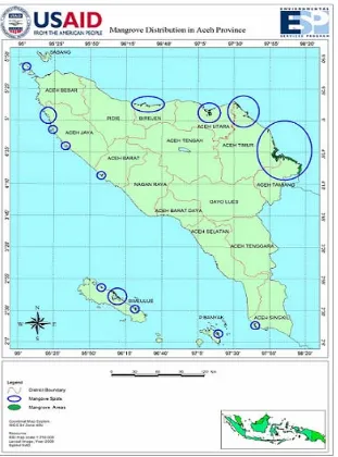
The most extensive mangrove areas on Aceh’s east coast were in Aceh Timur and Aceh Tiamang. Moderate amounts of mangrove were also found in Aceh Utara and Bireun. Although very limited in area, mangrove forest could also be found in some places on the west coast, i.e. Aceh Jaya, Aceh Barat and Aceh Singkil. There were also extensive areas of mangrove on the east coast of Simeuleu island, and moderate amounts on the east coast of Pulau Banyak island. The map in Figure 2-2 below shows mangrove distribution in NAD province in 2000.
Figure 2-2. Map of Mangrove Distribution in NAD Province (Landsat image, 2000)
Table 2-1. Extent of mangrove forest in Aceh Province before the Tsunami
Source of data Year Extent (ha)
Bina Program 1982 54,335
Silvius et al. 1987 55,000
INTAG 1996 60,000
Giesen et al. 1991 60,000 Forestry Planology Agency 2002 24,000
In 2004, the Department of Forestry announced in a press release that mangroves covered 296,078 ha on the east coast, 49,760 ha on the west coast and a total of 1000 ha in the Simeuleu District (press release no. S. 32/II/PIK-1/2004).
In 2000, however, the Department of Forestry had reported that only 30,000 ha of Aceh’s coastal mangrove forest was still in good condition, including the mangroves on Simeuleu Island. A total of 286,000 ha of mangrove was in moderate condition, and 25,000 ha badly degraded.
One area of mangrove forest still in good condition and growing densely, according to a study done in January 2004, was that on the coast of Ulee Iheue, before it was swept by the Tsunami. An analysis of the vegetation in this forest recorded 167 Rhizophora stylosa trees and 9 Rhizophora apiculata in a small plot measuring only 10m x 10m (Siswani Dari, 2004).
BOX 2-2. Green belt policy and spatial planning
The green belt is the zone of protected mangrove which is maintained all along the coast and which it is forbidden to cut down, convert or damage. The function of this mangrove green belt, in principle, is to preserve the coast from the threat of erosion and to act as a nursery and breeding ground for a variety of fish species.
Government policy to formulate a green belt began in 1975 with the publication of a decree by the Director General for Fisheries (SK Dirjen Perikanan No H.I/4/2/18/ 1975) which pronounced the need to maintain a belt of land along the coast, with a width of 400m measured from the average low tide level. The Director General for Forestry subsequently issued decree No. 60/KPTS/DJ/I/ 1978 concerning guidelines for silviculture in areas of brackish water. This decree stipulated a 10m wide green belt along the length of rivers, and a 50m-wide one along the coast, measured from the lowest point at low tide.
In 1984, the Forestry and Agriculture ministers issued joint decrees No. KB 550/246/ KPTS/1984 and No. 082/KPTS-II/1984, which called for the conservation of a 200m wide green belt along the coast, forbade the felling of mangrove trees in Java, and placed a conservation order on all mangroves growing on small islands (less than 1,000 ha.)
In 1990, Presidential Decree No. 32 concerning the Management of Conservation Areas replaced all previous regulations on green belt and granted more satisfactory protection to green belt zones. The decree stipulated that coastal mangrove green belt should be a minimum of 130 times the average tide, measured landwards from the point of the lowest tide mark. In practice, however, this decree suffered from a number of weaknesses as regards its application in the field. Some of the criticisms leveled at the decree are as follows:
• The decree cannot be applied to areas which, as a result of exploitation or conversion at some time in the past, no longer possess mangroves. Provision has to be made for this.
• This decree cannot be used to make an effective determination of green belt on very wide flat shores or mud flats. In several such areas, if the green belt is measured from the lowest point at low tide, it will comprise nothing but mud flats and will not reach as far as the mangroves. This problem can be solved by having a definition of measurement that starts from the seaward edge of the mangrove.
• This decree does not press for the protection of mangroves as a whole nor of their ecological function. It disregards their ecological interdependence with, for example, terrestrial mangrove, freshwater sources or freshwater swamps. Unless the supporting ecosystems are also protected in a properly integrated manner, the future survival of the green belt will be at risk.
• This decree gives only one choice, conservation. This choice is inadequate for areas where the intensive utilization of mangroves has long been a tradition, with the result that it will be difficult to reach consensus on the management of mangroves in such areas. In Java, for example, almost the entire mangrove area has been utiized by the inhabitants for aquaculture ponds and for a variety of other uses which do not, in fact, support mangrove conservation.
In 1993, the Forestry Department advocated that the total extent of protected areas needed to be doubled from 15 million to 30 million hectares. This was relevant to much of the nation’s mangroves. In response, a variety of organizations active in the field of nature conservation submitted proposals for new conservation areas and extensions to existing ones. One proposal for an additional 630,000 hectares of mangrove to be conserved was submitted by the Asian Wetland Bureau / Wetlands International – Indonesia Programme in 1994.
2.2 BEACH FOREST
2.2.1 Distribution and extent of forest in NAD province
Forest which suffered direct impact from the Tsunami was that near to the coast, often referred to as ’beach forest’. Unfortunately, there is no data on the extent of beach forest in NAD province as it is not listed separately but classified under Primary Dry Forest or Secondary Dry Forest.
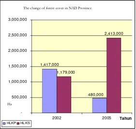
All the data obtained from various sources always indicates a decrease in forest area from year to year. Satellite image interpretation for 1999-2000 shows that NAD province had 1,417,000 ha Primary Dry Forest (Hutan Lahan Kering Primer/HLKP) and 1,179,000 ha Secondary Dry Forest (Hutan Lahan Kering Sekunder/HLKS) (Dept Forestry, 2002). Images for 2002-2003, however, show 480,000 ha of Primary and 2,413,000 ha of Secondary Dry Forest (Dept Forestry, 2005). So, in only 3-4 years, Primary Dry Forest had decreased by 937,000 ha while Secondary Dry Forest had increased by 1,234,000 ha, mainly due to the degradation of Primary forest caused by its exploitation for timber, both legal and illegal.
Figure 2-3. Changes to the extent of forest cover in NAD Province
2.2.2 Biodiversity
To date, no comprehensive study has yet been done specifically on the biodiversity of the whole of NAD province. Studies which have been done are generally scattered and not comprehensive. They are the result of observation, research or monitoring carried out in separate areas. One body of data that could be used as a basis for comparison for forest diversity in NAD is the data on the biodiversity of the Leuser Ecosystem, which covers:
More than 4,500 species of vegetation
Perubahan Luas Hutan di Propinsi NAD
1,417,000
434 species of birds
392 species of mammal
171 species of herpetofauna (amphibians & reptiles)
350 species of insect, and
81 species of fish (UML Database, 2002, in Irfan,2002)
This means that around 45% of the total estimated number of plant species in the West Indomalayan region, 85% of all the bird species in Sumatra, and 54% of the estimated total land fauna species in Sumatra, are all found in the Leuser Ecosystem.
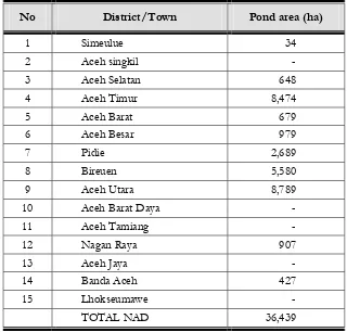
2.3 AQUACULTURE PONDS
According to the Fisheries and Marine Affairs Department (2005), the total area covered by aquaculture ponds in NAD province before the Tsunami was estimated to be 36,597 hectares. Of this, the largest area was in Aceh Utara (10,520 ha), followed by Aceh Timur (7,822 ha) and Pidie (5,056 ha). Most of these had previously been flourishing mangrove forests, which investors had then cut down and converted to ponds. Their two main reasons for choosing these sites had been:
To sell the wood obtained from cutting down the trees during land clearing. Thus the investors would receive money before starting to construct the ponds.
BOX 2-3. Biodiversity in Beach Forest, Pulot village – Aceh Besar
With its unique conditions, from the ocean shore in the west to the hills in the east, the Pulot area still provides good habitat for a wide variety of wildlife species. Sightings have been recorded of no fewer than 44 species of bird, including 3 species of hornbill and 3 species of eagle/birds of prey. Around 15 species of mammal are thought to live here still, based on evidence including actual sightings, the discovery of animal spoors, food remnants and feces, and information from the local inhabitants. Herpetofauna diversity has not yet been studied specifically, but the small streams that flow between the hills are thought to offer habitat that could be home to some of the 171 species of amphibians and reptiles recorded to have been found in the Leuser Ecosystem (KEL).
Although the Pulot area is not as rich as the Leuser Ecosystem, a brief study by a survey team from Wetlands International Indonesia Programme found that it is still habitat for a number of rare and protected species, such as gibbons Hylobates syndactylus, Hylobates agilis, Presbytis thomasi, several species of hornbill (Bucerotidae), birds of prey/eagles (Accripitidae), and Honey sucker bird (Nectarinidae) (Hasundungan, 2006).
Compared to upland forest, trees in beach forest are much smaller but grow at high densities. Tree species generally found in beach forest include Pterospermum diversifolium, Eugenia cumini, Alstonia macrophylla,
The mangrove forest environment is particularly suitable for the cultivation of shrimps and milkfish because it possesses a source of brackish water. Ponds will therefore be cheaper to construct as the land will not need to be modified.
The area taken up by aquaculture ponds on the west coast was much less, only 289 ha in Aceh Barat 25 ha in Aceh Utara.
Aceh dalam Angka (2004) presents the data in more detail and differing somewhat from that provided by the Fisheries and Marine Affairs Department (2005). This document specifies the area covered by aquaculture ponds in each district/town as shown in Table 2.2 below.
Table 2-2. Total area of aquaculture ponds for each district/town in NAD Province
No District/Town Pond area (ha)
1 Simeulue 34
2 Aceh singkil - 3 Aceh Selatan 648 4 Aceh Timur 8,474 5 Aceh Barat 679 6 Aceh Besar 979
7 Pidie 2,689
8 Bireuen 5,580
9 Aceh Utara 8,789 10 Aceh Barat Daya -
11 Aceh Tamiang - 12 Nagan Raya 907
13 Aceh Jaya -
14 Banda Aceh 427
15 Lhokseumawe -
TOTAL NAD 36,439
Source: Aceh Dalam Angka 2004
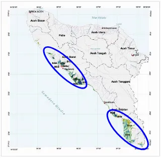
2.4 PEATLAND
Figure 2-4. Map of peatland distribution in NAD Province (WIIP, 2005)
The extent of peatland in each district in NAD province, based on the depth of the peat, is listed below, starting from the most extensive :
Very shallow peat (< 50 cm): Aceh Barat 21,867 ha (57.1%) and Aceh Selatan 16,403 ha (42.9%).
Shallow peat (50 – 100cm): Aceh Selatan 15,181 ha (76.8%) and Aceh Barat 4,591 ha (23.2%).
Moderate depth (100-200 cm) peat, found in: Aceh Selatan 96,900 ha (67.0%) and Aceh Barat 47,852 ha (33.0 %).
Deep peat (200 – 400 cm): Aceh Selatan 40,150 ha (56.4%) and Aceh Barat 31,107 ha (43.6%). Based on the types and degree of decomposition, the peat composition of each layer found in NAD is:
Very shallow peat: Hemists/mineral and Saprists/Hemists and Saprists/mineral.
Shallow peat: Hemists/mineral, Saprists/Hemists and Saprists/mineral.
Moderate depth peat: Hemists/Saprists, Hemists/mineral, Saprists/Hemists and Saprists/mineral.
Deep peat: Hemists/Saprists and Saprists/Hemists (WI-IP, 2006)
Based on field observation and information from the local community, the peatland had become degraded several years before the Tsunami. In Cot Rambong village in the district of Nagan Raya, hundreds of hectares of peatland forest had been completely cut down and converted to oil palm plantation. To make matters worse, this damage had been further exacerbated by the digging of canals at right angles to the peat dome. Local inhabitants reported that this area was often subject to fire in the dry season because the peat was so dry.
Figure 2-5. Degradation of peatlands (Cot Rambong village, Nagan Raya)
2.5 SWAMP
The Planology Agency (Forestry Department) classifies swamp into several types of cover. These are: Primary Swamp Forest, Secondary Swamp Forest, Swamp Shrub, and Unforested Swamp. Data from ETM 7 Landsat imaging in 1999 and 2000 showed the extent of each type to be as follows:
Primary swamp forest: 1000 ha.
Secondary swamp forest: 17,000 ha.
Swamp shrub: 3000 ha.
Open swamp (unforested) 3000 ha. (Dept Forestry, 2002)
However, very different conditions were shown by the ETM 7 Landsat imaging for 2004:
Primary swamp forest: none remaining
Secondary swamp forest: 165,000 ha.
Swamp shrub: 37 ha.
Open swamp (unforested) 10,000 ha. (Dept Forestry, 2005)
Freshwater swamp ecosystems are rich in aquatic plant biodiversity, including Pistia stratiotes, Nyampae nouchali, Lotus Nelumbo nucifera, Echinodorus paleafolius, Hydrocleydes spp., and Typha anguistifolia.
2.6 SANDY BEACH VEGETATION
Information and data describing the condition of sandy beaches in NAD province are sorely limited. However, their condition before the Tsunami can be seen clearly from the remains of trees and other vegetation found along the sandy beaches. From observations of these and from information supplied by the local community, it can be deduced that the dominant species growing on the sandy beaches along Aceh’s west coast just before the Tsunami struck included, among others: Casuarina equisetifolia, Hibiscus tilaceus, Pongamia pinnata, Ficus septica, Timonus compressicaulis, Pterospermum diversifolium, Cerbera manghas, and Barringtonia asiatica.
Aceh’s west coast is dominated by sandy beach, which stretches from Banda Aceh to Nagan Raya. It is reported to have been very common for communities living on the west coast to grow plantations of coconut Cocos nucifera and rubber Havea brasiliensis. Usually, coconut groves were planted near the coast, and rubber plantations further inland.
Two formations of coastal vegetation commonly found near the beach were the Pes-caprae Formation and Barringtonia Formation.
2.6.1 Pes-caprae formation
As its name suggests, this formation is dominated by the herb Ipomea pes-caprae, which is common on dune strands. The herbs grow slowly from the back edge of the beach towards the front and sides. Its rate of growth and expansion depends heavily on the condition of the substrate. If the substrate is stable, the plant will grow rapidly and dominate the back part of the sandy beach. This herb is usually also followed by the growth of other species of grass such as Spinifex littoreus, Cyperus maritima, Ischaemum muticum, and herbs such as Desmodium umbellatum, Vigna marina, Crotalaria striata, and
Calopogonium mucunoides.
For practitioners of coastal rehabilitation, Ipomea pes-caprae also functions as a biological indicator that the area is especially suitable for the planting of Casuarina equisteifolia, Callophyllum innophyllum, Cerbera manghas, Terminalia catappa, Baringtonia asiatica, Pongamia pinnata, Hibiscus tiiaceus and other beach trees. According to information from the local community, before the Tsunami Ipomea pes-caprae only inhabited the back part of the sandy beaches. After the Tsunami, however, it was found growing far inland.
2.6.2 Barringtonia Formation
This formation is usually found behind Pes-caprae formation, on sand mixed with ordinary mineral soil. An examination of the remnants of trees and plants left on the sandy beaches indicates that this formation consisted of big trees such as Barringtonia asiatica, Cerbera manghas, Terminalia cattapa, breadfruit Artocarpus sp., Morinda citrifolia, Erithryna variegate, Hibiscus sp., Hernandia peltata, and sea pine
Causarina equisetifolia.
3. Coastal Conditions After the Tsunami
3.1 IMPACT OF THE TSUNAMI AND EARTHQUAKE ON ACEH’S COAST
The 10-15 metre high Tsunami travelling at more than 40 km per hour which hit the coast of Aceh caused tremendous damage, the most devastating of which was along the length of Aceh’s west coast (comprising Aceh Barat and Nagan Raya), the district (kabupaten) of Banda Aceh, Aceh Jaya, and Aceh Besar.
According to the analysis carried out by LAPAN, of the 21 districts/towns in NAD Province, at least 15 were affected by the earthquake and Tsunami, while the total area affected was 649,582 ha, including 131,810 ha of wet ricefields, 9448.5 ha of swamp, and 32,004 ha of mangrove forest and coastal vegetation.
Damage to coastal areas was caused not only by the Tsunami but also by the violent earthquake that altered the landscape along the west coast of Aceh and the islands of Simeulue and Nias. The following paragraphs describe some of the impacts on these coastal areas, both those resulting from the Tsunami and those from the earthquake.
Damage to coastal ecosystems arising from the Tsunami was brought about by two mechanisms:
Mechanism 1 : the energy of the Tsunami, which directly struck the coast and destroyed mangrove forests, casuarina (sea-pine) stands, coconut groves, and a range of other vegetation. This happened extremely fast. Vegetation was damaged, parts torn off. In the worst struck areas, mangrove trees were uprooted from their substrate by the force of the waves.
Mechanism 2 : inundation by the sea water brought by the Tsunami, the high salinity of which caused coastal vegetation to become stressed, dry up and die. Plant death due to saltwater inundation always happened gradually. Unlike the destruction resulting from the force of the wave, the trees that died from inundation were generally still seen to be whole and standing upright.
Almost all of the formations and types of vegetation existing along Aceh’s west coast were severely damaged. More than 60,000 ha of ricefields were totally destroyed as a result of sea water inundation. To date, only 21.6 % of the total area of ricefield has yet been rehabilitated, while most of the remainder has been abandoned (BRR, 2005). Neither mangrove forests, beach forests, sea pine forests, swamps nor any other type of vegetation along the coast escaped damage. The following paragraphs describe the damage done to several types of wetlands along the coast.
3.1.1 Changes to the coastal landscape of Aceh, Simeulue island and Nias island
subsidence causing the shoreline to advance 100 to 200 meters inland. On Simeulue island, in contrast, part of the land was lifted up by 2 meters, thereby exposing the coral reef and killing the mangrove forest. The same happened in the north part of Nias island, causing similar damage to the coral reef and mangrove. Nevertheless, not all parts of Nias were lifted up. In the southern part of the island, the land subsided thus causing the shoreline to advance inland by 200 meters. Figure 3-1 below gives a general picture of the landscape change, based on field observations by the WI-IP Team on the west coast of Aceh, Simeulue island and Nias island.
Figure 3-1. Landscape change caused by earthquake and Tsunami along Aceh coast
The greatest impact from subsidence was on the west coast of Aceh. Along almost the whole length of Aceh’s west coast the shoreline moved 200 meters inland. What had once been areas of human habitation, coconut groves and rubber plantations, etc. is now part of the ocean. For the inhabitants, the greatest impact (apart, of course, from the loss of loved ones) has been the loss of their land, coconut trees and other property upon which their livelihoods depended. Similar land subsidence also occurred on the southern edge of Nias island.
Seen from another angle, the loss of a substantial part of the coastland also means the loss of prospective rehabilitation sites. In other words, the available space has decreased as a result.
Onolimbu
Lahewa Labuhan Bakt i
Cot Rambong Lhok Bubon
Figure 3-2. Loss of land as a result of earthquake and Tsunami (Lhok Bubon, Aceh Barat)
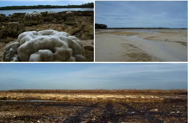
The uplifting of land on Simeulue island and the northern part of Nias island not only exposed the coral reef, causing it to dry out and die, but also had a detrimental impact on the mangrove forest which, now too high above sealevel to be inundated by sea water, also dried out and died (see Figure 3-3 below).
Figure 3-3. Impact of uplifting of substrate: coral reef exposed and dying in Labuhan Bhakti-Simeulue, emergence of new land in Alus-alus- Simeulue, and dried, dead mangrove in Lahewa, Nias (clockwise)
These changes to the landscape on Aceh’s west coast, Simeulue and Nias islands automatically have an effect on the availability of land for rehabilitation, as follows:
Subsidence along Aceh’s west coast accompanied by the advance of the shoreline and consequent loss of land automatically reduces the space potentially available for rehabilitation activities.
3.1.2 Degradation of mangrove forest
Degradation of mangrove due to the impact of the Tsunami
Mangrove forests were one of the types of wetland which suffered the worst damage. This was because, being on the edge of the coast, they were directly hit by the full force of the Tsunami. Towering an average of 10-15 m in height, the Tsunami destroyed the mangrove forests in a matter of seconds. Mangroves were devastated along almost the whole length of Aceh’s west coast and part of the east coast.
Figure 3-4. Mangrove forest destroyed by Tsunami in Tibang – Aceh Besar
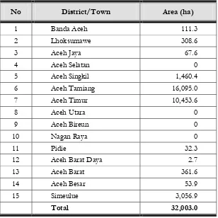
Data varies widely as to the extent of mangrove forest damaged by the Tsunami. Bappenas (2005) estimates it to be 25,000 ha. Lapan (2005), however, gives a higher figure stating that 32,003 ha of Aceh’s mangrove forest was severely damaged by the Tsunami, as detailed in Table 3-1 below.
BOX 3-1. The status and management of new and lost land (resulting from landscape change)
Changes to the landscape along the west coast of Aceh, Simeulue and Nias islands have created problems concerning the status both of the land lost and the new land that has emerged. For those inhabitants whose land has become part of the ocean, the problem is one of loss. According to information obtained during field observation, they want the government to compensate them by providing them with land in a different location but still nearby the land which they have lost. To date, however, it is still unclear how this problem is being handled and what stage of progress has been reached in the process towards a solution.
As regards the new land that has emerged due to the uplifting of the substrate, the foremost problem is the question of who has the responsibility for this land. According to a variety of different parties, this new land belongs to the state and an institution should be appointed without delay to administer it. In addition, the future utilization of this land is still undecided. However, there is little or no possibility of planting mangrove or coastal species on it as much of it is covered by coral.
Table 3-1. Area of mangrove forest damaged by Tsunami in NAD province
No District/Town Area (ha)
1 Banda Aceh 111.3 2 Lhoksumawe 308.6 3 Aceh Jaya 67.6 4 Aceh Selatan 0 5 Aceh Singkil 1,460.4 6 Aceh Tamiang 16,095.0 7 Aceh Timur 10,453.6
8 Aceh Utara 0
9 Aceh Bireun 0
10 Nagan Raya 0
11 Pidie 32.3
12 Aceh Barat Daya 2.7
13 Aceh Barat 361.6 14 Aceh Besar 53.9 15 Simeulue 3,056.9
Total 32,003.0
Source: Lapan
By interpreting volunteers’ photographs of the coast and other available information, it can be estimated that the extent of Tsunami damage to mangrove was as follows:
1. Aceh Besar 100% (approximately 26,823 ha) 2. Banda Aceh 100% (<500 ha)
3. Pidie 75% (17,000 ha)
4. Aceh Utara and Bireun 30% (26,000 ha) 5. Aceh Barat 50%, (14,000 ha}
Figure 3-5. Surviving young mangrove stand belonging to the community
Damage to the mangrove forests was not limited to the loss of several species of mangrove, but also devastated the mangrove’s habitat. The loss of the mature trees automatically means the loss of seed production, while the degradation of so much of the mangrove habitat means a great reduction in the area suitable for replanting mangrove.
Degradation of mangrove due to lifting of the substrate
Besides the impact of the Tsunami, another cause of mangrove degradation was the lifting of the substrate with the result that the mangrove was no longer inundated by the ocean tides. This phenomenon was frequently found on Simeulue island and part of Nias island’s coast.
Observation of the impact of substrate uplifting on the mangrove forest was carried out by the WI-IP Team in September 2005 in Lahewa village on Nias. It was found that the tides no longer reached the mangrove, with the result that almost all of the mangrove trees had dried up. The dominant species in Lahewa’s mangrove forest was Rhizophora apiculata, while Ceriops decandra was found sporadically in gaps between the Rhizophora apiculata.
Figure 3-6. Mangrove which has desiccated due to uplifting of the substrate at Lahewa village, Nias.
In the vicinity of the mangrove forest, several other species of mangrove were found to be growing well on the dry land. These were Aegiceras corniculatum, Ceriops decandra, Xylocarpus rumphii and
Dolichandrone spathacea.
The assessment team also discovered that the floor of the mangrove stands had been invaded by a number of pioneering species, in particular Acrostichum aureum. This indicates that the floor of the mangrove stands is now never inundated by sea water. If these conditions persist, the invasion will continue until the entire forest floor is covered with this vegetation (Suryadiputra et all, 2005).
Figure 3-7. Invasion of mangrove stand floor by pioneer species of vegetation
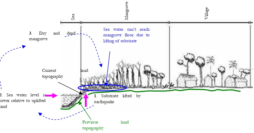
Figure 3-8. Illustration of mangrove death caused by lifting of the substrate at Lahewa-Nias A. Mangrove condit ion bef ore lif t ing of subst rat e
Normal level of sea water
Se
a
Mangrove Village
Mangrove growing well
B. Mangrove condit ion af t er lif t ing of subst rat e
2. Sea water level is lower relative to uplifted land
3. Dry and dead
mangrove
Se
a
Mangrove Village
1. Substrate lifted by earthquake
Previous land topography
Current land topography
Sea water can’t reach mangrove floor due to lifting of substrate
3.1.3 Degradation of aquaculture ponds
Aquaculture ponds, generally constructed behind the shoreline or mangrove forest, did not escape being hit by the Tsunami, which destroyed the dykes, ditch banks, water channels, water-gates, and buildings. According to data from the Fisheries and Marine Affairs Department, almost half of the total pond area suffered serious damage. In Banda Aceh, all the ponds were destroyed. Table 3-2 below presents the Department’s analysis of the area of aquaculture ponds damaged by the Tsunami in NAD province.
Table 3-2. Area of aquaculture ponds damaged by the Tsunami
No District/Town Pond area before Tsunami (ha)
Source: Fisheries and Marine Affairs Department, 2005
Data from BRR suggests that the figure is higher, stating that the total area of aquaculture ponds which were either destroyed or made unusable reached 20,000 ha. Of these, 5000 ha or 25% have been repaired and are ready to function again.
There is a strong link between pond rehabilitation and coastal reafforestation, in particular the planting of mangroves. This is because, in Aceh, the majority of mangrove planting has been in aquaculture ponds. Ideally, mangrove planting should be done after the pond has been repaired, so that the dykes are clear to see and the deposits left by the Tsunami have been removed. If mangroves are planted before the ponds are repaired, there is a risk that the seedlings will be destroyed by the heavy equipment used to reconstruct the ponds.
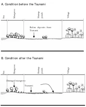
The material deposited consisted mostly of sand, ranging from fine to coarse. Ponds were one of the recepticles for these deposits, which were up to 0.5 metres thick. The illustrations in Figure 3-10 below show two different conditions: that before and that after the Tsunami. Diagram B is a cross-section of the condition actually observed in the field, showing the mangrove damage and Tsunami deposits, while diagram A shows the condition before the Tsunami based on field observations enriched with information from the local community.
Figure 3-10. Condition of aquaculture ponds at Lham Ujong before (top) and after (bottom) the Tsunami
The deposited material totally altered the condition of the ponds, causing the land’s carrying capacity to decline drastically to the point that the area was no longer suitable for aquaculture. The ponds had, however, been an important asset to the community because they provided a source of income. For that reason, one of the most important programs carried out by the government and several NGOs has been the rehabilitation of these ponds. The rehabilitation activies generally consisted of removing the materials deposited by the Tsunami and rebuilding the damaged dykes.
Se
At present, most of the mangrove planting in NAD province has been in coastal aquaculture ponds. However, only a small proportion of this can be considered successful, the majority having failed. Indications suggest that one factor which played a role in this failure is the Tsunami deposits. To find out in more depth about the impact of Tsunami deposits on mangrove planting, a study was carried out at Lham Ujong, Aceh Besar (see Box 3-2).
BOX. 3-2. The impact of Tsunami deposits on the environment’s carrying capacity (Case study in Lham Ujong village)
The Tsunami brought material from the sea and deposited it as far as 1 - 2 km inland. In order to determine the impact of this deposit, a case study was carried out by an Assessment Team from Wetlands International in August-September 2005 in the coastal area of Lham Ujong village (Aceh Besar). The study found that coarse material (like sand) had been deposited in locations near the shoreline to a thickness of 20 – 50 cm. This deposit then formed a solid soil structure which caused a decrease in the soil’s aeration capability and which transmitted heat easily. Under such conditions, the seedlings’ rooting process was seriously obstructed. Meanwhile, finer material (dust and clay) has been deposited further inland. If this material has been deposited on coastal plain to a thickness of less than 20 cm, it will have a more beneficial effect as it will supply additional minerals thus making the soil more fertile. (See Figure 3-11 below).
Coastal
Figure 3-11. Correlation between location of Tsunami deposit and success of mangrove rehabilitation in Lham Ujong village, Aceh Besar
Preliminary results illustrated in the diagram above are as follows:
1. Mangrove planted in ponds containing thick Tsunami deposits are less likely to survive. This is strongly believed to be because the deposit is formed of coarse and solid materials. Such conditions cause the seedlings to become stressed and then die. Thick deposits are generally found in ponds near the shoreline.
3.1.4 Degradation of Peatland
All of the peatland in NAD province is situated on the west coast, where the Tsunami hit hardest. Ecological assessment conducted by WI-IP in Cot Rambong village (Nagan Raya district) found that the Tsunami had reached peatland areas. The sea water dumped there by the Tsunami was unable to flow away and became trapped in the peat. Being highly saline, it had a detrimental effect on the peat and on the vegetation above. Some plants became stressed and subsequently died as a result. It was even reported that entire rubber plantations had died from the effect of the sea water entering the peatland where they were growing.
3.1.5 Degradation of swamp
Swamp affected by the Tsunami was generally in areas close to the coast. As well as physical damage from the force of the Tsunami, swamps also suffered damage due to inundation by sea water, one obvious result of this being the death of some of the swamp vegetation.
Based on the interpretation of satellite images, Lapan (2005) states that 9,448.5 ha of swamp were affected by the Tsunami. The district of Aceh Jaya suffered the greatest area of swamp damage (3,126.8 ha), followed by Aceh Timur (1,558 ha) and Aceh Besar (945.9 ha). A list of the area of swamp damaged in each district is given in Table 3-3 below.
Table 3-3. Area of swamp damaged by Tsunami
In addition to swamplands, a total of 131,809.7 hectares of ricefields in NAD province were affected by the Tsunami. Lhokseumawe was the district with the greatest area of damaged ricefield (39,929.4 ha) while Aceh Utara had the smallest (11.9 ha). Besides ricefields, at least 22,618.7 hectares of dry agricultural land was also affected by the Tsunami, the most damage being in Aceh Timur (9,199.5 ha) (Lapan 2005).
Observations in Lhok Bubon village, Aceh Barat revealed that the Tsunami had inundated swamps behind the sandy beach. This had increased the salinity of the swamp, thereby causing several species of swamp vegetation to die. Aside from sea water inundation, vegetation along the coast had also been severely damaged by the force of the Tsunami when it struck. Figure 3-12 below illustrates the impact of the Tsunami on swampland.
Figure 3-12. Condition of swamp before and after the Tsunami, at Lhok Bubon-Aceh Barat
Sea pin
Swamp area Village Swamp area
Normal level of
Swamp area Village Swamp area
3.1.6 Degradation of coastal vegetation
Coastal terrestrial vegetation is defined as all types and formations inhabiting dry land in coastal area, not growing in inundated or tidal zones. Terrestrial vegetation includes beach forest, rubber plantation, coconut plantation, cultivated gardens, barringtonia formation, and casuarina pine forest, etc. It is estimated that the damage caused by the Tsunami to this kind of ecosystem covered more than 80,795 ha (source: EU Joint Research Center).
Figure 3-13. Damage to coastal zone of West Aceh, caused by Tsunami
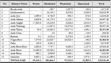
Table 3-4 below lists the areas of forest, shrubland, plantation and open land affected by the Tsunami in NAD province.
Table 3-4. Area of forest, shrubland, plantation and open land affected by Tsunami (Ha)
No District/Town Forest Shrubland Plantation Open land Total
1 Banda Aceh - 180.7 1,507.9 183.8 1,872.40
2 Lhokseumawe - 14,114.1 8,676.8 2,035.0 24,825.90
3 Aceh Jaya 3,499.0 8,763.9 595.3 676.0 13,534.20
4 Aceh Selatan 6,629.6 14,179.5 3,118.1 570.4 24,497.60
5 Aceh Singkil 17,922.8 14,314.0 3,626.6 2,913.4 24,477.11
6 Aceh Tamiang - 11,847.6 14,674.6 1,505.4 28,027.60
7 Aceh Timur 50.3 16,203.2 10,577.0 1,641.1 28,471.60
8 Aceh Utara - 3.0 84.5 119.0 206.50
9 Bireuen 0.1 3,531.6 5,276.0 1,120.8 9,928.50
10 Nagan Raya 7,074.0 22,025.7 26,623.6 342.8 56,066.10
11 Pidie 139.4 4,201.2 - 1,338.3 5,678.90
12 Aceh Barat Daya 2,005.0 7,747.7 8,685.5 1,127.0 19,565.20
13 Aceh Barat 12,449.8 19,520.2 9,833.4 4,015.6 45,819.00
14 Aceh Besar 692.1 2,964.0 3,434.1 345.6 7,435.80
15 Simeulue 8,983.1 11,069.6 808.4 3,975.1 24,836.20
TOTAL NAD 59,445.2 150,666.3 97,521.8 21,909.3 329,542.60
The Tsunami’s sweeping devastation of the coastland and its vegetation is apparent all along the west coast of Aceh. The wave’s force was so great that it smashed all the vegetation up to several kilometres inland.
Figure 3-14. Impact of Tsunami: coconut tree (left) and pine (right) broken, swept by the Tsunami at Lhok Nga-Aceh Besar Vegetation along the coast was damaged and killed not only by the direct force of the Tsunami but also as a result of sea water inundation which lasted for several days. In general, it was areas far inland that were inundated.
Figure 3-15. Effect of sea water: Breadfruit tree alive and healthy (left), Mangosteen tree dead as a result of sea water inundation (right)
3.1.7 The formation of lagoon ecosystems as a result of the Tsunami (case study at Pulot village, Leupung sub-district, Aceh Besar)
As a result of the Tsunami on 26 Desember 2004, followed by the earthquake in March 2005, a new type of coastal wetland was formed, called a lagoon. A lagoon is defined as a body of water (similar to a lake) near the coast, which had previously formed part of the sea or been connected to the sea but, due to a geological event, became separated from the sea and formed a new coastal wetland ecosystem. The assessment carried out by the Wetlands International team on the west coast of Aceh in 2005 found at least 4 new lagoons that had been formed due to the Tsunami, one of them in Pulot village. Corresponding to the definition above, the Pulot village lagoon had originally been a river estuary facing the sea (not a habitat that formed part of the sea). When the Tsunami struck, sea water traveled far upriver (making it part of the sea), then the mouth of the estuary became blocked by deposits of sand brought up from the sea and material from the land. Thus the Krueng Pulot estuary became separated from the sea and formed a lagoon.
Figure 3-16. Lagoon at Pulot village, formed by the Tsunami
Steps must be taken urgently to protect the Pulot lagoon, for a number of reasons which include the following:
1. The management status of the lagoon is unclear, which could encourage over exploitation of its resources.
2. The banks of the lagoon are eroding, which could accelerate shallowing of the lagoon and cloud its waters.
3. The waters of the lagoon are threatened with pollution from a number of potential sources, both from Tsunami debris and from current activities being carried out in the area of the lagoon. 4. The lagoon promises great economic and ecotourism potential which can contribute to the
future development of Pulot village.
5. The lagoon is a natural reservoir which can mitigate flooding of the surrounding land during high tides and rain.
6. It can prevent the subterranean intrusion of sea water to the surrounding land (especially if the lagoon is filled with freshwater from rainfall).
7. Its high biodiversity holds good potential for fisheries, with a variety of economically valuable fish species.
8. The lagoon creates a micro-climate for the surrounding area, making the air feel fresher and more pleasant.
In order to protect the lagoon, it needs to be managed in an integrated manner which involves the participation of the local community. Some of the matters that must be undertaken include the following: 1. Determine the lagoon’s management status through the participation of the local community (including mapping, zoning of the lagoon and its surrounding area, and the formulation of regulations for the utilization of resources in and around the lagoon).
2. Prepare seedlings which will later be planted around the lagoon in order to prevent abrasion of the lagoon walls to prevent the surrounding area from becoming arid.
3. Clear away the debris left by the Tsunami both in and around the lagoon.
4. Raise the community’s awareness of the lagoon’s functions and benefits to the economy and to the aquatic environment.
5. Promote the beauty of the lagoon for eco-tourism, so as to increase income to the local community.
3.2 REGENERATION AND PRESENT CONDITION OF VEGETATION
3.2.1 Regeneration of mangrove
Figure 3-17. Mangrove habitat so badly devastated that mangrove can not recover
However, in several places (one being Lamsenia village, Aceh Besar) the regeneration of Nypa fruticans
and Avicennia spp was progressing well. From information provided by the local inhabitants, it was discovered that some trees had survived the Tsunami. These have managed to live and can produce seeds, as a result of which the stands of Nypa fruticans and Avicennia spp. are able to recover (see Figure 3-18).
Figure 3-18. Regeneraton of Nypa(left) and Avicennia (right).
3.2.2 Regeneration of coastal vegetation
Moments after the Tsunami, almost all the vegetation along the coast had gone leaving nothing but open space. Now, however, coastal conditions have changed as succession and regeneration have occurred naturally along Aceh’s west coast. Areas that had been completely bare of any vegetation are now supporting the growth of a variety of species.