city’s resiliency against the occurrence of natural disasters and to achieve sustainable development.
KEY WORDS: Comprehensive Land Use Plan, danger zone, natural hazards, resiliency, vulnerability, zoning ordinance
INTRODUCTION
The Philippines being a locus of typhoons, tsunamis, earthquakes and volcanic eruptions, is a hotbed of natural disasters. Natural disasters inflict loss of lives and costly damage to property. In 2011, the devastating impacts of Typhoons Pedring, Quiel and Sendong resulted in a high number of fatalities with economic losses amounting to billions of pesos” (http://noah.dost.gov.ph/, Dec. 3, 2012). Based upon this characterization of the Philippines and the disaster brought about by Pablo in December 2012, it is but timely that the issue on climate change alongside disaster risk reduction be given ample attention. One study posited that: “Land use planning can influence mitigation of disasters through the development of strategic land use plan as well as assessment of development applications on the basis of the adopted plan,” (Bajracharya, 2011). The foregoing proposition was the inspiration in conducting this study in order to assess how land use planning and management be able to support disaster risk reduction and management efforts in Iligan City. The impact of Tropical Storm Sendong delivered a clear message to the local government of Iligan to review and reconsider its policies and policy initiatives toward the mitigation and
preventionof natural disasters.
Reduction and Management
Framework of the Philippines
http://dx.doi.org/10.18196/jgp.2015.0009
ABSTRACT
Various studiesclaimed the feasibility and pos-sible success of implementing land use manage-ment and planning policies in helping in the mitigation and reduction of disaster risks such as loss of lives, destruction of infrastructure and loss of livelihood. According to one source: “Land use management is a method used mainly by municipal governments in using land for sustainable commu-nity development by controlling where, what, and how to construct facilities or buildings,” (EqTAP, 2003).
In ensuring sustainable development for future generations, taking into consideration their safety and welfare, the local government of today should take into consideration growth and risk reduction alongside sustainable development in order to improve human security and ensure environmen-tal protection. Thus, land use planning and man-agement is a part of the entire effort.
Land use planning is not only a technical pro-cess but a political exercise that involves multiple participants. This makes it a lengthy process that requires compromises and strong policy leadership. In the case of Iligan, the formulation of the 2013-2022 CLUP started in 2011 and at the time that this paper is being written, the process is still ongoing. It is not only the local politics in the city that contributed into the extended timeline of the process but also the participation of at least five agencies such as the City Development Council (CDC), Sangguniang Panlungsod (SP), Regional Land Use Committee (RLUC), Housing and Land Use Regulatory Board (HLURB) and Housing and Urban Development Coordinating Council
(HUDCC). Moreover, series of public consultations are also required. Nevertheless, the main features of the 2013-2022 CLUP are already established and
most of the ensuing debates are mainly for refine-ments and clarifications.
The hazard map of Iligan was prepared by the Mines and Geo-science Bureau of the Department of Environment and Natural Resources in 2010. Likewise, the DRRM Framework of the Philip-pines was passed in the same year. Since the formulation of the 2013-2022 CLUP started in 2011, it must conform to the hazard map of Iligan and the DRRM Framework of the Philippines.
THEORITICAL FRAMEWORK
Schematic Diagram Showing the Relationship between CLUP, Hazard Map, Disaster Risk Reduc-tion and Management Framework and Sustainable Development
As shown in the figure, the “Disaster Risk Reduction and Management (DRRM) Framework” of the Philippine Government and the “Hazard Map” of Iligan are the inputs in the formulation of the “Comprehensive Land Use Plan (CLUP)” of the city.
the DRRM framework of the Philippines. This framework provides the basis for mainstreaming DRRM strategies into the CLUP.
The “Hazard map” identifies specific vulnerabili-ties of the barangays of Iligan City to various natural hazards. It recommends precautionary measures that must be incorporated into the CLUP in order to address natural hazards faced by Iligan.
The CLUP on the other hand is a roadmap for the attainment of sustainable development of Iligan City. It provides for the plans and strategies in implementing land use policies by the local government.
In order to achieve sustainable development, the CLUP should conform with the DRRM Framework of the national government and the hazard map of Iligan. Thus, the purpose of having a CLUP aligned with the Hazard Map and the DRRM Framework is to achieve sustainable development. The local government of Iligan should develop resilience against natural disasters by promoting disaster mitigation, prevention, and preparedness through land use planning.
Land use planning in Iligan started in 1974 with the adoption of a town plan. By 1975, the first zoning ordinance (Ordinance No. 1313, series of 1975) was adopted and lasted until 2001 when it was amended by Ordinance No. 01-3949 known as the Zoning Ordinance of 2001. In 1997, land use planning took the form of Comprehensive Master Development Plan. A year later (1998), it finally became the 1995-2000 Comprehensive Land Use Plan which continued to be in effect even beyond 2000. However, in 2003, Iligan adopted the City Development Strategies that touched on some aspects of land use planning which to a limited
extent amended the 1995-2000 CLUP.
Taken altogether, CLUP, is a means in achiev-ing sustainable development. Its effectiveness for this purpose is determined largely by its congruence with the Philippine DRRM Framework and the Hazard Map of Iligan.
RESULT AND ANALYSIS
This study evaluated the provisions of both the old(1995-2000) and new (2013-2022) CLUPs of Iligan City to find out if they have integrated the four pillars of Disaster Risk Reduction and Man-agement: disaster prevention and mitigation, disaster preparedness, disaster response, and disaster rehabilitation and recovery. Inclusion of these into the CLUP would increase the level of resilience of the city against various hazards that put both humans and environment at risk.
A. FEATURES OF THE OLD CLUPRELEVANT TO
DISASTER RISK REDUCTION AND
MANAGE-MENT
The features of the old CLUP (1995-2000) that are relevant to DRRM are the provisions for “Easements, Floodway and Waterway Require-ments (Sec. 37) of the Zoning Ordinance of 2001 (No. 01-3949). Though insufficient in terms of its prescriptions and coverage, these features provided a minimal safety net to residents and their proper-ties against the threat posed by natural hazards, particularly floods and storm surges that threat-ened people living near rivers, creeks and shore-lines.
rehabili-tation and recovery. An example of this is the lack of specific provisions for “Danger Zones” and the insuffi-ciency in the provision about “Buffer zones” in relation to hazards and disasters. Generally, danger zones and buffer zones should not be inhabited. In the case of danger zones, structures may only be allowed with proper mitigation features to be incorporated in their designs.
In the language of both of the Zoning Ordinance of 2001 as well as its predeces-sor, the Zoning Ordinance of 1975, “disas-ters”, “hazards” and “danger zones” were not included. While they mentioned categorization of zones, there was no mention of “danger zones.” Apparently, these terminologies have not yet come into the chronology of land use planning in Iligan in 1975 and 2001.
These shortcomings were shown by observations made across areas identified as zones for easements. As observed in some areas of the city, such requirements on easements, floodways and waterways have not been properly implemented by the LGU as evidenced by many instances where many houses encroached into spaces suppos-edly to be reserved as easements, obviously neglecting the provisions set forth by said Zoning Ordinance.
This lack of congruence between this CLUP (1995-2000) along with the Zoning Ordinances of 1975 and 2001 to the DRRM Framework is due mainly to the fact that these local legislations were passed before the enactment of Republic Act (R.A.) No. 10121 in 2010. R.A. No. 10121, the DRRM Code of the Philippines was passed by the Philippine legislature in cognizance with the intensifying pattern of natural disasters of hydro-meteorological origins. The non-congruence was costly for Iligan, since all Sendong related deaths in 2011 happened in danger zones which the Mines and Geo-science Bureau (MGB) had identified in 2010.Nevertheless, even if only
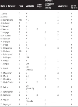
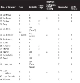
Legend: Flood C=Common; R=Rare; R&L=Rare and Low; S=Seasonal; N=None Landslide:H=High; M=Moderate; L=Low; N-L=None to Low; L-M= Low to Moderate
X- barangay where hazard is likely to happen and may affect the community
Note:Barangay is the basic political subdivision in the Philippines. Each city and municipality is subdivided into barangays. For administrative supervision each barangay is also subdivided into puroks.
the provision on easement was observed, many lives could have been spared from Tropical Storm Sendong.
The continuing disregard of the provisions on ease-ments, floodways and waterways does not only threaten lives and properties but also causes water pollution. People occupying these areas throw their wastes into the water. Untreated water coming from various sources in the city end up into the Iligan Bay thus progressively polluting it. These resulted to the deterioration of the water quality of the bay which used to be one of the most productive fishing grounds in Northern Mindanao.
B. NATURAL HAZARDS FACED BY ILIGAN CITY
The natural hazards faced by Iligan City as identified
by the Mines and Geoscience Board (MGB) – Region X are categorized into six, namely: (1) Floods; (2) Landslides; (3) Storm surge; (4) Earthquakes; (5) Liquefaction; and (6) Storm/Typhoon. Each of these hazards has been identified through a “Rapid
Geohazard Assessment” of all the barangays of Iligan City in March 2010. The MGB – Region X has also provided the City Plan-ning and Development Office
(CPDO)geohazard maps showing Iligan City in relation to potential hazards it may encounter.These natural hazards have been identified to pose a major threat to human lives, properties, livelihoods and sustainable development.
C. INTEGRATION OF DISASTER RISK
REDUCTION AND MANAGEMENT
AND CLIMATE CHANGE ADAPTATION
INTO ILIGAN CITY’S 2013-2022CLUP
The 2013-2022 CLUP is a lengthy document consisting of the three volumes: volume 1 presents the land use of the city; volume 2 provides the provisions of the zoning ordinance; and volume 3 contains the sectoral studies conducted. Volume 2 is the most politicized portion of the CLUP because it needs the enactment by the city council (Sangguniang Panlungsod) to be-come an ordinance.
In 2011, the City Planning and Develop-ment Office (CPDO) initiated the revision of Iligan City’s CLUP. Its provisions were made to conform to the implementing rules and regulations set forth by R.A 10121. New features were incorporated specifically in
Legend: Flood C=Common; R=Rare; R&L=Rare and Low; S=Seasonal; N=None Landslide:H=High; M=Moderate; L=Low; N-L=None to Low; L-M= Low to Moderate
X- barangay where hazard is likely to happen and may affect the community
the new CLUP’s Volume 3: Sectoral Studies; revision on Chapter 3.1.1: Housing Sector; Chap-ter 4: Environmental Protection, Climate Change Adaptation and Disaster Risk Reduction Sector; and Volume 2: Zoning Ordinance. These features contain tables of (1) Analysis matrices with their corresponding strategized Programs/Projects/ Activities; (2) Geo-hazard Maps by the Mines and Geosciences Bureau (MGB) – Region X; (3) Vulner-ability Assessment Matrix Environment Sector; and (4) an Updated and improved version of the Comprehensive Zoning Ordinance of Iligan City in which strategies and mechanisms of DRRM and CCA were incorporated.
The first feature is the Analysis Matrices with its corresponding strategized Programs/Projects/ Activities. It was the product of series of workshops facilitated by the CPDO and participated by vari-ous stakeholders and agencies. In the series of workshops they sorted out and discussed the
pressing concerns and issues about the susceptibility of the city to various hazards. These matrices include (1) Protection and Conservation Analysis Matrix, (2) Land Quality Analysis Matrix, (3)
Development Constraints and (4) Housing Analysis Matrix.
On the other hand, aside from the identified concerns and issues they also came up with poten-tial solutions which conform to the provisions of DRRM and CCA in addressing the identified concerns and issues. The solutions were categorized into two parts: “Mitigation” and “Adaptation Measures” which aim to lessen or alleviate the vulnerabilities of the city to hazards. These solu-tions are in a form of policy intervensolu-tions and options and building of infrastructures. Moreover, the solutions would be further strengthened
through the different programs, projects and activities designed by the CPDO and to be imple-mented by various agencies in the city
The second feature is the Geohazard Maps generated by the MGB-Region X which were considered as inputs in the formulation of the new CLUP. These Geohazard Maps show the different barangays and communities affected by various natural hazards. These Maps include (1) Slope Map of Iligan City, (2) Flood Susceptibility Map of Iligan City, (3) Landslide Susceptibility Map of Iligan City (4) Storm Surge Susceptibility Map of Iligan City and (5) Map of Location of Clusters of Informal Settlers. These maps serve as a helpful guide in the formulation and implementation of the Zoning Ordinance.
The third feature is the Vulnerability Assess-ment Matrices which evaluate the level of vulner-ability against three (3) hazards: flood, landslide, and storm surge, specifically in the natural environ-ments of Iligan City which includes Mt. Gabunan in Barangay Rogongon; Mangrove areas in Barangays Hinaplanon, Santiago and Sta. Felomina; Marine Sanctuary in Barangay Dalipuga; and the major rivers in the city that include Iligan River, Agus River and Mandulog River. Every matrix includes each narrated impact or exposure, the rate of likelihood or probability that it may happen, the corresponding conse-quences and risk score and description of the risk which is categorized respectively as Low Risk, Medium Risk or High Risk.
hazard profile and mainstream DRRM and Cli-mate Change Adaptation (CCA) principles. Provi-sions in the proposed zoning ordinance include conformity to R.A. 10121 and R.A. 9729; and the new definition of a Buffer Zone which now con-form to the current conditions and needs of the city’s natural and human environments. There is also an inclusion of an overlay zone where more than one land use is allowed in order to optimize the usage of a land. Moreover, selective permits for building houses in danger zones maybe allowed provided that mitigation measures are integrated into infrastructures’ design.
CONCLUSION
The provisions under Iligan City’s old CLUP (1995-2000) did not explicitly mention ideas related to the DRRM Framework or principles stipulated in R.A. 10121 as it was adopted as a local ordinance in 1998,twelve years before R.A. 10121 was en-acted. The operation of the 1995-2000 CLUP was extended for more than a decade due to the failure to amend it. Prior to 2011, land use planning in Iligan City did not place much consideration on issues arising from climate change.
Being not grounded on the concept of DRRM as elucidated in RA 10121, the old Zoning Ordi-nance (OrdiOrdi-nance No. 01-3949) is short of provi-sions that ensures resiliency against natural haz-ards. Consequently,buildings for residential, commercial and industrial purposes were not made to withstand the effects of natural disasters like the flood that was brought by Tropical Storm Sendong in 2011. The vulnerability of city infrastructures to hazards was shown by the extent of destructions wrought by Tropical Storm Sendong in 2011 where many houses along the coast of Iligan Bay and near
the banks of Mandulog River were swept away by strong current.
As identified by the MGB – Region X, the natural hazards faced by Iligan City are categorized into six, namely: (1) Floods; (2) Landslides; (3) Storm surge; (4) Earthquakes; (5) Liquefaction; and (6) Storm/Typhoon.With the pressing concerns to incorporate DRRM and the prescriptions of R.A. 10121, Iligan through the CPDO has taken the initiative of revising the 1995-2000CLUP to incor-porate the pillars of DRRM. This revision has been initiated as a response to the national government’s call for coping up with natural hazards and the disasters brought by unprepared-ness and disregard.
The new features integrated into the 2013-2022 CLUP are: (1) Analysis matrices with its corre-sponding strategized Programs/Projects/Activities; (2) Geohazard Maps generated by the Mines and Geosciences Bureau (MGB)-Region X; (3) Vulner-ability Assessment Matrix Environment Sector; and (4) an Updated version of the Comprehensive Zoning Ordinance of Iligan City where the strate-gies and mechanisms of DRRM and CCA have been incorporated into the new CLUP of Iligan City.
These efforts indicate that the city is gradually assimilating the importance of DRRM and CCA in the city’s development planning efforts. It also shows that the new CLUP hadincorporated the pertinent provisions required by R.A 10121. This would make the new CLUP serve as an effective guideline to improve and increase the level of resiliency of the city and secure the sustainable development of Iligan against the threats brought about by various hazards.
the content of both the old and new CLUPs and not to include monitoring and evaluatingthe outcome of their implementation. Nevertheless, it is hereby posited that the success of CLUP of Iliganlies mainly on its effective implementation. With local politics putting its weight on the policy making process in Iligan which is causing the delay of the completion of the formulation of the new CLUP, great challenges awaits its approval and implementation
RECOMMENDATIONS
1. The MGB should provide Geohazard Maps for each barangay in Iligan City. These maps focused in each barangay should reflect the identified hazard/s in each barangay concerned. These maps are important in formulating DRRM actions plans in every barangay espe-cially in mitigation, preparedness and response. 2. In partnership with the academe, the MGB
should also conduct further researcheson the history and pattern of the occurrence of hazards in Iligan City. The outputs of these researches shall provide vital information needed in enhancing the resiliency of the vulnerable communities in Iligan.
3. The CLUP of the city should be reviewedat least every three years in order incorporate new updates resulting from current researches on Climate Change Adaptation (CCA) and DRRM.
4. The local government of Iligan should conduct thorough information drive regarding the zoning ordinance of the city through the tri-media. It should also strictly implement the provisions of the Zoning Ordinance and incor-porate them into all development programs of
the city.
5. The Local Disaster Risk Reduction Manage-ment Office of Iligan should go into community organizing and regular response drills to up-grade community preparedness in dealing with natural disasters.
6. The City Environment and Natural Resources Office (CENRO) should strictly regulate the release of environmental certificates for devel-opment projects or activities that may bedone in buffer and danger zones.
7. The City Zoning Administrator should impose more strict guidelines on the release of location certificates and building permits in consider-ation with the geohazard map of the city and with the pertinent provisions of R.A. 10121. 8. As front-liners, chairmen of barangays should
exercise leadership at the grassroots level for the education of their constituents on the contents of CLUP in order to foster well-informed compliance.
9. Finally, Iligan City should develop the culture of safety and the value of ecological balance. This is done through the partnership between the city government, barangays, religious leaders, NGOs, POs, and the academe.
REFERENCES
GOVERNMENT DOCUMENTS
Comprehensive Land Use Plan of Iligan City 1995-2000. (1998). City Planning and Development Office. Retrieved April 18, 2013.
Comprehensive Land Use Plan of Iligan City 2013-2022. City Planning and Development Office. Retrieved April 18, 2013.
13, 2013.
Iligan City Zoning Ordinance of 2001. City Plan-ning and Development Office. Retrieved April 18, 2013.
Iligan City Zoning Ordinance of 2011. City Plan-ning and Development Office. Retrieved April 18, 2013.
Portable Document Formats (PDFs)
Bajracharya, Brishna, et al. (January 2011). Cli-mate Change Adaptation through Land Use Planning and Disaster Management: Local Government Perspectives from Queensland. Gold Coast, Queensland, Australia: 17th Pacific Rim Real Estate Society Conference. Retrieved Nov. 24, 2012, from http://www.prres.net/ papers/Bajracharya_Childs_Hastings_Climate_- change_disaster_management_and_land-_use_planning.pdf
CLUP Guide Book: A Guide to Comprehensive Land Use Plan Preparation Vol.1. (2006). Hous-ing and Land Use Regulatory Board. Retrieved March 10, 2013 from http://hlurb.gov.ph/wp-content/uploads/services/lgu/full-text-vol1.pdf Introduction to Storm Surge. (n.d.). United States of America: National Weather Service, National Oceanic and Atmospheric Administration. Retrieved Jan. 26, 2014 from http://
www.nws.noaa.gov/om/hurricane/resources/ surge_intro.pdf
Risk Assessment and Hazard Mapping CLUSTER 5: Hazard and Risk Information and Decision Making. (n.d). World Bank. Retrieved: March 14, 2013 from
http://wbi.worldbank.org/wbi/Data/wbi/
wbicms/files/drupal-acquia/wbi/drm_kn5-1.pdf Salzer, Walter PhD. (September 2011). A Policy
Brief on the Cost of Land Use Planning in the
Philippines. Environment and Rural Develop-ment ogram. Retrieved: March 14, 2013 from http://www.enrdph.org/docfiles/
2012Oct_Costs
%20of%20Land%20Use_%20Policy%20Brief_web.pdf Internet Sources
EqTAP. (2003). Development of Land Use Man-agement Guideline for Municipal Govern-ments. Retrieved Nov. 25, 2012 from http:// eqtap.edm.bosai.go.jp/useful_outputs/report/ banba/banba.htm
Fernandez, Amanda et al. (December 2012). December storms Pablo and Sendong are a rarity in Mindanao. GMA News. Retrieved from http://www.gmanetwork.com/news/ story/284797/news/regions/december-storms-pablo-and-sendong-are-a-rarity-in-mindanao Iligan City: Profile. (n.d.). Retrieved Jan. 22, 2013,
from http://www.iligan.gov.ph/about-iligan/ city-profile-3/
Land Use Planning. (1999). Retrieved March 10, 2013 from http://www.fao.org/nr/land/use/ en/
NOAH. (n.d.). Department of Science and Tech-nology. Retrieved Dec. 3, 2012 from http:// noah.dost.gov.ph
The Science of Earthquakes. United States of America: United States Geological Survey. Retrieved Jan. 26, 2014 from http://
earthquake.usgs.gov/learn/kids/eqscience.php Interviews
Interview with Architect Gil Balondo (CPDO Coordinator), City Planning and Development Office, Iligan City on February 3, 2014.
Planning and Development Office, Iligan City on March 6 and 13, 2013.