Licensed by INDECOPI to CTN Información geográfica y geomática - Dr. Jorge Lescano Reference number
ISO 19152:2012(E)
STANDARD 19152
First edition 2012-12-01
Geographic information — Land
Administration Domain Model (LADM)
Information géographique — Modèle du domaine de l’administration des terres (LADM)
Licensed by INDECOPI to CTN Información geográfica y geomática - Dr. Jorge Lescano
COPYRIGHT PROTECTED DOCUMENT
© ISO 2012
All rights reserved. Unless otherwise specified, no part of this publication may be reproduced or utilized in any form or by any means, electronic or mechanical, including photocopying and microfilm, without permission in writing from either ISO at the address below or ISO's member body in the country of the requester.
ISO copyright office
Case postale 56 • CH-1211 Geneva 20 Tel. + 41 22 749 01 11
Fax + 41 22 749 09 47 E-mail [email protected] Web www.iso.org Published in Switzerland
Licensed by INDECOPI to CTN Información geográfica y geomática - Dr. Jorge Lescano
Contents
PageForeword ...v
Introduction...vi
1 Scope ...1
2 Conformance ...1
3 Normative references...2
4 Terms, definitions, and abbreviations...2
4.1 Terms and definitions ...2
4.2 Abbreviations...6
5 Overview of the LADM ...7
5.1 Packages and subpackages of the LADM ...7
5.2 Basic classes of the LADM...8
5.3 Party Package ...9
5.4 Administrative Package ...9
5.5 Spatial Unit Package ...10
5.6 Surveying and Representation Subpackage ...11
6 Content of classes of the LADM and their associations ...12
6.1 Introduction...12
6.2 Special classes ...12
6.2.1 VersionedObject ...12
6.2.2 Fraction...14
6.2.3 Oid...14
6.2.4 LA_Source...15
6.3 Classes of Party Package ...16
6.3.1 LA_Party...16
6.3.2 LA_GroupParty ...18
6.3.3 LA_PartyMember ...18
6.3.4 Code lists for Party Package...18
6.4 Classes of Administrative Package...19
6.4.1 LA_BAUnit...19
6.4.2 LA_RRR ...21
6.4.3 LA_Right...22
6.4.4 LA_Restriction ...23
6.4.5 LA_Responsibility ...23
6.4.6 LA_Mortgage...23
6.4.7 LA_AdministrativeSource...24
6.4.8 LA_RequiredRelationshipBAUnit ...24
6.4.9 Code lists for Administrative Package...25
6.5 Classes of Spatial Unit Package ...26
6.5.1 LA_SpatialUnit ...26
6.5.2 LA_SpatialUnitGroup ...27
6.5.3 LA_LegalSpaceBuildingUnit ...28
6.5.4 LA_LegalSpaceUtilityNetwork ...29
6.5.5 LA_Level...30
6.5.6 LA_RequiredRelationshipSpatialUnit...30
6.5.7 Data types for Spatial Unit Package ...31
6.5.8 Code lists for Spatial Unit Package ...31
6.6 Classes of Surveying and Representation Subpackage ...32
6.6.1 LA_Point ...32
6.6.2 LA_SpatialSource...33
Licensed by INDECOPI to CTN Información geográfica y geomática - Dr. Jorge Lescano
6.6.3 LA_BoundaryFaceString...34
6.6.4 LA_BoundaryFace ...35
6.6.5 Data types for Surveying and Representation Subpackage ...35
6.6.6 Code lists for Surveying and Representation Subpackage ...36
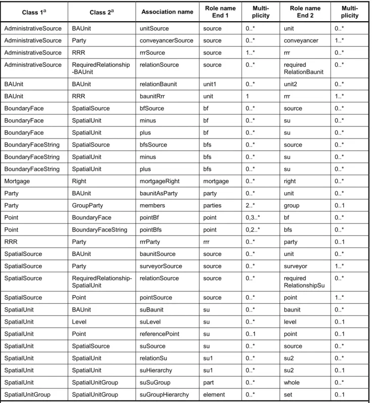
6.7 Associations between classes ...38
Annex A (normative) Abstract test suite...40
Annex B (normative) 2D and 3D representations of spatial units...48
Annex C (informative) Instance level cases ...50
Annex D (informative) Country profiles ...71
Annex E (informative) Spatial units and spatial profiles ...82
Annex F (informative) Legal profiles ...88
Annex G (informative) The LADM and INSPIRE ...91
Annex H (informative) The LADM and LPIS...93
Annex I (informative) Social Tenure Domain Model (STDM)...99
Annex J (informative) Code lists...101
Annex K (informative) External classes ...103
Annex L (informative) Interface classes...108
Annex M (informative) Modelling land administration processes...110
Annex N (informative) History and dynamic aspects ...111
Annex O (informative) LADM and other ISO/TC 211 international standards ...112
Bibliography ...117
Licensed by INDECOPI to CTN Información geográfica y geomática - Dr. Jorge Lescano
Foreword
ISO (the International Organization for Standardization) is a worldwide federation of national standards bodies (ISO member bodies). The work of preparing International Standards is normally carried out through ISO technical committees. Each member body interested in a subject for which a technical committee has been established has the right to be represented on that committee. International organizations, governmental and non-governmental, in liaison with ISO, also take part in the work. ISO collaborates closely with the International Electrotechnical Commission (IEC) on all matters of electrotechnical standardization.
International Standards are drafted in accordance with the rules given in the ISO/IEC Directives, Part 2.
The main task of technical committees is to prepare International Standards. Draft International Standards adopted by the technical committees are circulated to the member bodies for voting. Publication as an International Standard requires approval by at least 75 % of the member bodies casting a vote.
Attention is drawn to the possibility that some of the elements of this document may be the subject of patent rights. ISO shall not be held responsible for identifying any or all such patent rights.
ISO 19152 was prepared by Technical Committee ISO/TC 211, Geographic information/Geomatics.
Licensed by INDECOPI to CTN Información geográfica y geomática - Dr. Jorge Lescano
Introduction
This International Standard defines the Land Administration Domain Model (LADM). The LADM is a conceptual model, and not a data product specification (in the sense of ISO 19131).
The purpose of the LADM is not to replace existing systems, but rather to provide a formal language for describing them, so that their similarities and differences can be better understood. This is a descriptive standard, not a prescriptive standard.
Land administration is a large field; the focus of this International Standard is on that part of land administration that is interested in rights, responsibilities and restrictions affecting land (or water), and the geometrical (geospatial) components thereof. The LADM provides a reference model which will serve two goals:
⎯ to provide an extensible basis for the development and refinement of efficient and effective land administration systems, based on a Model Driven Architecture (MDA), and
⎯ to enable involved parties, both within one country and between different countries, to communicate, based on the shared vocabulary (that is, an ontology), implied by the model.
The second goal is relevant for creating standardized information services in a national or international context, where land administration domain semantics have to be shared between regions, or countries, in order to enable necessary translations. Four considerations during the design of the model were that:
⎯ it will cover the common aspects of land administration all over the world;
⎯ it will be based on the conceptual framework of ‘Cadastre 2014’ of the International Federation of Surveyors (FIG) [14];
⎯ it will be as simple as possible in order to be useful in practice;
⎯ the geospatial aspects follow the ISO/TC 211 conceptual model.
Until now, most countries (or states, or provinces) have developed their own land administration system. One country operates a deeds registration system, another a title registration system. Some systems are centralized, and others decentralized. Some systems are based on a general boundaries approach, others on fixed boundaries. Some systems have a fiscal background, others a legal one. The different implementations (foundations) of the various land administration systems do not make meaningful communication across borders easy. However, looking from a distance, one will observe that the different systems are in principle largely the same: they are all based on the relationships between people and land, linked by (ownership or use) rights, and are in most countries influenced by developments in Information and Communication Technology (ICT). Furthermore, the two main functions of every land administration (including cadastre and/or land registry) are:
⎯ keeping the contents of these relationships up-to-date (based on regulations and related transactions);
and
⎯ providing information from the (national) registers.
Land administration is described as the process of determining, recording and disseminating information about the relationship between people and land. If ownership is understood as the mechanism through which rights to land are held, we can also speak about land tenure. A main characteristic of land tenure is that it reflects a social relationship regarding rights to land, which means that in a certain jurisdiction the relationship between people and land is recognised as a legally valid one. These recognised rights are in principle eligible
Licensed by INDECOPI to CTN Información geográfica y geomática - Dr. Jorge Lescano for registration, with the purpose being to assign a certain legal meaning to the registered right (e.g. a title).
Therefore, land administration systems are not just 'handling geographic information’, as they represent a lawfully meaningful relationship amongst people, and between people and land.
As land administration activity on the one hand deals with huge amounts of data, which moreover are of a dynamic nature, and on the other hand requires a continuous maintenance process, then the role of ICT is of strategic importance. Without the availability of information systems it will be difficult to guarantee good performance with respect to meeting changing customer demands. Organizations are now increasingly confronted with rapid developments in technology, a technology push (the Internet, geospatial databases, modelling standards, open systems, and GIS), as well with a growing demand for new services, a market pull (e-governance, sustainable development, electronic conveyance, and the integration of public data and systems). Modelling is a basic tool, facilitating appropriate system development and reengineering and, in addition, it forms the basis for meaningful communication between different systems.
Standardization has become a well-known process in the work of land administrations and land registries. In both paper-based systems and computerized systems, standards are required to identify objects, transactions, relationships between objects (e.g. parcels, generally referred to as spatial units) and persons (e.g. citizens, legally referred to as subjects and generally referred to as parties), classification of land use, land value, map representations of objects, and so on. Computerized systems require further standardization when topology and the identification of single boundaries are introduced. In existing land administrations and land registries, standardization is generally limited to the region, or jurisdiction, where the land administration (including cadastre and/or land registry) is in operation. Open markets, globalization, and effective and efficient development and maintenance of flexible (generic) systems, require further standardization.
The scope of this International Standard is provided in Clause 1. Conformance in relation to this International Standard is given in Clause 2, and a conformance test is specified in Annex A. Normative references are presented in Clause 3 and the used terms, definitions and abbreviations in Clause 4. Clause 5 gives a global overview of packages. Clause 6 introduces the classes, attributes and associations in detail. Annex B explains the 2D and 3D representations of spatial units. A comprehensive set of informative examples (using instance level classes) is available in Annex C.
It must be noted that this is a generic domain model. It is expandable and it is likely that additional attributes, operators, associations, and perhaps even additional classes, will be needed for a specific region or country;
see the country profiles in Annex D. Specific parts of the LADM are further detailed: the spatial profiles in Annex E and the legal profiles in Annex F. Some examples of using the LADM in a specific context are: the INSPIRE cadastral parcels in Annex G, the integration of the LADM with the agricultural Land Parcel Identification Systems (LPIS) of the European Union in Annex H, and the Social Tenure Domain Model (STDM) in Annex I. It is possible to use only a subset, or profile, of the LADM for a specific implementation.
Annex J gives an overview of code tables as a basis to describe a flexible enumeration.
The construction of external databases with party data, address data, taxation data, land use data, land cover data, valuation data, physical utility network data, and archive data, is outside the scope of the LADM.
However, the LADM provides stereotype classes for these data sets (if available), see Annex K. Interface classes are in Annex L. Annex M makes some remarks in relation to process models. History and dynamic aspects are included in Annex N. Annex O explains the link to other ISO international standards.
Licensed by INDECOPI to CTN Información geográfica y geomática - Dr. Jorge Lescano
Geographic information — Land Administration Domain Model (LADM)
1 Scope
This International Standard:
⎯ defines a reference Land Administration Domain Model (LADM) covering basic information-related components of land administration (including those over water and land, and elements above and below the surface of the earth);
⎯ provides an abstract, conceptual model with four packages related to
1) parties (people and organizations);
2) basic administrative units, rights, responsibilities, and restrictions (ownership rights);
3) spatial units (parcels, and the legal space of buildings and utility networks);
4) spatial sources (surveying), and spatial representations (geometry and topology);
⎯ provides terminology for land administration, based on various national and international systems, that is as simple as possible in order to be useful in practice. The terminology allows a shared description of different formal or informal practices and procedures in various jurisdictions;
⎯ provides a basis for national and regional profiles; and
⎯ enables the combining of land administration information from different sources in a coherent manner.
The following is outside the scope of this International Standard:
⎯ interference with (national) land administration laws that may have any legal implications;
⎯ construction of external databases with party data, address data, valuation data, land use data, land cover data, physical utility network data, archive data and taxation data. However, the LADM provides stereotype classes for these data sets to indicate which data set elements the LADM expects from these external sources, if available; and
⎯ modelling of land administration processes.
2 Conformance
The LADM consists of three packages and one subpackage, and for each of them a conformance test is specified in Annex A. Three conformance levels are specified per (sub)package: level 1 (low level), level 2 (medium level), and level 3 (high level). Level 1 tests the basic classes per package and level 2 also includes the more common classes. Level 3 includes all classes. Any LADM claiming conformance to this International Standard shall satisfy the requirements of Annex A.
Licensed by INDECOPI to CTN Información geográfica y geomática - Dr. Jorge Lescano
3 Normative references
The following referenced documents, in whole or in part, are normatively referenced in this document and are indispensable for its application. For dated references, only the edition cited applies. For undated references, the latest edition of the referenced document (including any amendments) applies.
ISO 4217:2008, Codes for the representation of currencies and funds
ISO 8601:2004, Data elements and interchange formats — Information interchange — Representation of dates and times
ISO/IEC 13240:2001, Information technology — Document description and processing languages — Interchange Standard for Multimedia Interactive Documents (ISMID)
ISO 14825:2011, Intelligent transport systems — Geographic Data Files (GDF) — GDF5.0 ISO/TS 19103:2005, Geographic Information — Conceptual schema language
ISO 19105:2000, Geographic Information — Conformance and testing ISO 19107:2003, Geographic Information — Spatial schema
ISO 19108:2002, Geographic Information — Temporal schema
ISO 19111:2007, Geographic Information — Spatial referencing by coordinates ISO 19115:2003, Geographic information — Metadata
ISO 19125-2:2004, Geographic information — Simple feature access — Part 2: SQL option ISO 19156:2011, Geographic information — Observations and measurements
4 Terms, definitions, and abbreviations
4.1 Terms and definitions
For the purposes of this document, the following terms and definitions apply.
4.1.1
administrative source
source (4.1.21) with the administrative description (where applicable) of the parties (4.1.13) involved, the rights (4.1.20), restrictions (4.1.19) and responsibilities (4.1.18) created and the basic administrative units (4.1.2) affected
EXAMPLE 1 It is the evidence of a party’s right to a basic administrative unit.
EXAMPLE 2 A document describing a transaction (a deed), or a judgement of the register holder.
4.1.2
basic administrative unit baunit
administrative entity, subject to registration (by law), or recordation [by informal right (4.1.20), or customary right, or another social tenure relationship], consisting of zero or more spatial units (4.1.23) against which (one or more) unique and homogeneous rights [e.g. ownership right or land (4.1.9) use right], responsibilities (4.1.18) or restrictions (4.1.19) are associated to the whole entity, as included in a land administration (4.1.10) system
Licensed by INDECOPI to CTN Información geográfica y geomática - Dr. Jorge Lescano NOTE 1 'Unique' means that a right, restriction, or responsibility is held by one or more parties (4.1.13) (e.g. owners or
users) for the whole basic administrative unit. 'Homogeneous' means that a right, restriction or responsibility (e.g.
ownership, use, social tenure, lease, or easement) affects the whole basic administrative unit. For a restriction, zero parties are a possibility.
NOTE 2 A basic administrative unit may play the role of party, e.g. when the right holder is a basic administrative unit (and not a person or organization).
NOTE 3 A baunit should get a unique identifier when registered, or recorded.
NOTE 4 A baunit can consist of zero spatial units, when a registry exists, and not a cadastre.
NOTE 5 Restrictions and responsibilities can be associated with their own baunits, each with their own type of spatial unit.
EXAMPLE A condominium unit comprising two spatial units (e.g. an apartment and a garage), a farm lot comprising one spatial unit (e.g. parcel of land), a servitude comprising one spatial unit (e.g. the road representing the right-of-way), a land consolidation area, or a right-of-use unit with several right holders and restricted objects.
4.1.3 boundary
set that represents the limit of an entity [ISO 19107:2003, 4.4]
NOTE Boundary is most commonly used in the context of geometry, where the set is a collection of points or a collection of objects that represent those points. In other arenas, the term is used metaphorically to describe the transition between an entity and the rest of its domain of discourse.
4.1.4
boundary face
face (4.1.7) that is used in the 3-dimensional representation of a boundary (4.1.3) of a spatial unit (4.1.23) NOTE Boundary faces are used when the implied vertical and unbounded faces of a boundary face string (4.1.5) are not sufficient to describe 3D spatial units. Boundary faces close volumes in height (e.g. every apartment floor), or in depth (e.g. an underground parking garage), or in all other directions to form a bounded volume. The volumes represent legal space (in contrast with physical space).
4.1.5
boundary face string
boundary (4.1.3) forming part of the outside of a spatial unit (4.1.23)
NOTE Boundary face strings are used to represent the boundaries of spatial units by means of line strings in 2D.
This 2D representation is a 2D boundary in a 2D land administration (4.1.10) system. In a 3D land administration system it represents a series of vertical boundary faces (4.1.4) where an unbounded volume is assumed, surrounded by boundary faces which intersect the Earth’s surface (such as traditionally depicted in the cadastral map).
4.1.6
building unit
component of building (the legal, recorded or informal space of the physical entity)
NOTE A building unit may be used for different purposes (e.g. living or commercial) or it can be under construction.
EXAMPLE An apartment, a flight of stairs, a threshold, a garage, a parking space or a laundry space.
4.1.7 face
2-dimensional topological primitive [ISO 19107:2003, 4.38]
NOTE The geometric realization of a face is a surface. The boundary of a face is the set of directed edges within the same topological complex that are associated to the face via the boundary relations. These can be organized as rings.
Licensed by INDECOPI to CTN Información geográfica y geomática - Dr. Jorge Lescano 4.1.8
group party
any number of parties (4.1.13), together forming a distinct entity, with each party registered NOTE A group party may be a party member (4.1.14) of another group party.
EXAMPLE A partnership (with each partner registered as a party), or two tribes (with each tribe registered as a party).
4.1.9 land
the surface of the Earth, the materials beneath, the air above and all things fixed to the soil [UN/ECE, 2004]
4.1.10
land administration
process of determining, recording and disseminating information about the relationship between people and land (4.1.9)
NOTE In many countries, land administration information is determined, recorded and disseminated under the umbrella of cadastre and land registry. Both institutions can be unified in a single (state) organization.
4.1.11 level
set of spatial units (4.1.23), with a geometric, and/or topological, and/or thematic coherence
EXAMPLE 1 One level of spatial units for an urban cadastre and another for spatial units for a rural cadastre.
EXAMPLE 2 One level of spatial units to define basic administrative units (4.1.2) associated with rights (4.1.20) and another level of spatial units to define basic administrative units associated with restrictions (4.1.19).
EXAMPLE 3 One level of spatial units to define basic administrative units associated with formal rights, a second level for spatial units to define basic administrative units associated with informal rights and a third level for spatial units to define basic administrative units associated with customary rights.
EXAMPLE 4 One level with point (4.1.15) based spatial units, a second level with line based spatial units, and a third level with polygon based spatial units.
4.1.12
liminal spatial unit
spatial unit (4.1.23) on the threshold between 2D and 3D representations 4.1.13
party
person or organization that plays a role in a rights (4.1.20) transaction
NOTE 1 In order to be registered as a party, not all members need to be identified and registered individually.
NOTE 2 A basic administrative unit (4.1.2) may be a party because it may hold a right of e.g. easement.
EXAMPLE An organization may be: a company, a municipality, the state, a tribe, a farmer cooperation, or a church community (with each organization represented by a delegate: a director, chief, CEO, etc.).
4.1.14
party member
party (4.1.13) registered and identified as a constituent of a group party (4.1.8) 4.1.15
point
0-dimensional geometric primitive, representing a position [ISO 19107:2003, 4.61]
Licensed by INDECOPI to CTN Información geográfica y geomática - Dr. Jorge Lescano NOTE 1 A point may be used to define one or more boundary faces (4.1.4) or boundary face strings (4.1.5).
NOTE 2 Points can be observed by, e.g. terrestrial surveying, but also by photo interpretation, image interpretation, or identification on an existing map.
4.1.16 profile
set of one or more base standards or subsets of base standards, and, where applicable, the identification of chosen clauses, classes, options and parameters of those base standards, that are necessary for accomplishing a particular function
[ISO 19106:2004, 4.5]
NOTE 1 A profile valid for a whole country is named a country profile (see Annex D).
NOTE 2 A profile is derived from base standards so that by definition, conformance to a profile is conformance to the base standards from which it is derived (see Annex A).
4.1.17
required relationship
explicit association between either spatial units (4.1.23), or between basic administrative units (4.1.2) NOTE 1 Due to legal aspects, history of data, inaccurate geometries or missing geometries, geospatial overlay techniques may generate invalid, or no relationships between spatial units, which can be introduced by required relationships.
NOTE 2 Relationships for spatial units may be defined with ISO 19125-2 types.
4.1.18
responsibility
formal or informal obligation to do something
EXAMPLE The responsibility to clean a ditch, to keep a snow-free pavement or to remove icicles from the roof during winter, or to maintain a monument.
4.1.19 restriction
formal or informal obligation to refrain from doing something
EXAMPLE 1 It is not allowed to build within 200 metres of a fuel station; or, a servitude or mortgage as a restriction to the ownership right (4.1.20).
EXAMPLE 2 Sequestration can be registered for baunit as a restriction.
4.1.20 right
action, activity or class of actions that a system participant may perform on or using an associated resource [ISO 19132:2007, 4.38]
NOTE 1 A right may provide a formal or informal entitlement to own or do something.
NOTE 2 This International Standard deals with real rights and personal rights. Real rights are rights over or in respect of spatial units (4.1.23) (e.g. ownership, or usufruct). Personal rights are rights that parties (4.1.13) have (e.g. fishing rights, grazing rights, or use rights).
NOTE 3 Rights may be overlapping, or may be in disagreement.
EXAMPLE Ownership right, apartment right, tenancy right, possessions, customary right, Islamic right (e.g. miri or milk), indigenous right, or informal right.
Licensed by INDECOPI to CTN Información geográfica y geomática - Dr. Jorge Lescano 4.1.21
source
document providing legal and/or administrative facts on which the land administration (LA) object [right (4.1.20), restriction (4.1.19), responsibility (4.1.18), basic administrative unit (4.1.2), party (4.1.13), or spatial unit (4.1.23)] is based
NOTE Any kind of document may be added as a source according to ISO 19115:2003, B.3.2.
4.1.22
spatial source
source (4.1.21) with the spatial representation of one (part of) or more spatial units (4.1.23)
EXAMPLE A field survey sketch, an orthophoto or a satellite image with evidence of the location of boundaries (collected from the field).
4.1.23 spatial unit
single area (or multiple areas) of land (4.1.9) and/or water, or a single volume (or multiple volumes) of space NOTE 1 A single area is the norm and multiple areas are the exception.
NOTE 2 Spatial units are structured in a way to support the creation and management of basic administrative units (4.1.2).
NOTE 3 This International Standard supports either 2-dimensional (2D), 3-dimensional (3D), or mixed (2D and 3D) representations of spatial units, which may be described in text (“from this tree to that river”), or based on a single point (4.1.15), or represented as a set of unstructured lines, or as a surface, or as a 3D volume.
NOTE 4 In addition to spatial units represented by a single point, text, or a set of unstructured lines, a spatial unit may have an area equal to zero for administrative reasons.
4.1.24
spatial unit group
any number of spatial units (4.1.23), considered as an entity
NOTE The spatial units in a spatial unit group are not necessarily continuous.
EXAMPLE Spatial units together forming an administrative zone such as a section, a canton, a municipality, a department, a province, or a country. Spatial units within a planning area.
4.1.25
utility network
network describing the legal space of the topology of a utility
NOTE 1 A utility network may be attributed with information about its legal, recorded or informal space.
NOTE 2 A utility network can also be modelled as a basic administrative unit (4.1.2).
EXAMPLE The legal space needed to access and to keep in repair a cable or pipeline utility network.
4.2 Abbreviations
baunit basic administrative unit
FIG International Federation of Surveyors GIS Geographical Information System GNSS Global Navigation Satellite System
INSPIRE Infrastructure for Spatial Information in Europe
Licensed by INDECOPI to CTN Información geográfica y geomática - Dr. Jorge Lescano
LA Land Administration
LADM Land Administration Domain Model RRR Right, Restriction, Responsibility STDM Social Tenure Domain Model
UML Unified Modelling Language
5 Overview of the LADM
5.1 Packages and subpackages of the LADM
The LADM, as a product, is a conceptual schema. The LADM is organized into three packages, and one subpackage. A (sub)package is a group of classes, with a certain degree of cohesion. Each (sub)package has its own namespace. (Sub)packages facilitate the maintenance of different data sets by different organizations.
The complete model may therefore be implemented through a distributed set of (geo-) information systems, each supporting data maintenance activities and the provision of elements of the model. The model may also be implemented by one or more maintenance organizations, operating at national, regional or local level. This underlines the relevance of the model: different organizations have their own responsibilities in data maintenance and supply, but may communicate on the basis of standardized administrative and technical update processes.
An overview of the (sub)packages (with their respective classes) is presented in Figure 1. The three packages are: (1) Party Package (see 5.3), (2) Administrative Package (see 5.4), and (3) Spatial Unit Package (see 5.5).
The Surveying and Representation Subpackage (see 5.6) is a subpackage of the Spatial Unit Package.
All figures are UML 2.1 diagrams. The LADM classes are prefixed by LA_ to differentiate them from other classes in the ISO geographic information series of standards.
Licensed by INDECOPI to CTN Información geográfica y geomática - Dr. Jorge Lescano
« co n ce p tu a l S ch e m a » Spatial Unit
+ L A _ S p a ti a l U n i t + L A _ S p a ti a l U n i tG ro u p + L A _ L e g a l S p a ce B u i l d i n g U n i t + L A _ L e g a l S p a ce U ti l i tyN e tw o rk + L A _ L e ve l
+ L A _ R e q u i re d R e l a ti o n sh i p S p a ti a l U n i t + L A _ A re a V a l u e
+ L A _ V o l u m e V a l u e + L A _ D i m e n si o n T yp e + L A _ B u i l d i n g U n i tT yp e + L A _ S u rfa ce R e l a ti o n T yp e + L A _ U ti l i tyN e tw o rkS ta tu sT yp e + L A _ U ti l i tyN e tw o rkT yp e + L A _ R e g i ste rT yp e + L A _ S tru ctu re T yp e + L A _ L e ve l C o n te n tT yp e + L A _ A re a T yp e + L A _ V o l u m e T yp e
+ S u rve yi n g a n d R e p re se n ta ti o n
(from LADM classes)
« co n ce p tu a l S ch e m a » Party
+ L A _ P a rty + L A _ G ro u p P a rty + L A _ P a rtyM e m b e r + L A _ P a rtyT yp e + L A _ P a rtyR o l e T yp e + L A _ G ro u p P a rtyT yp e
(from LADM classes)
« co n ce p tu a l S ch e m a » Surv eying and Representation
+ L A _ P o i n t + L A _ S p a ti a l S o u rce + L A _ B o u n d a ryF a ce S tri n g + L A _ B o u n d a ryF a ce + L A _ T ra n sfo rm a ti o n + L A _ P o i n tT yp e + L A _ S p a ti a l S o u rce T yp e + L A _ In te rp o l a ti o n T yp e + L A _ M o n u m e n ta ti o n T yp e
(from Spatial Unit)
« co n ce p tu a l S ch e m a » Administrativ e
+ LA_RRR + L A _ B A U n i t + L A _ R i g h t + L A _ R e stri cti o n + L A _ R e sp o n si b i l i ty + L A _ M o rtg a g e
+ L A _ A d m i n i stra ti ve S o u rce + L A _ R e q u i re d R e l a ti o n sh i p B A U n i t + L A _ A va i l a b i l i tyS ta tu sT yp e + L A _ B A U n i tT yp e
+ L A _ A d m i n i stra ti ve S o u rce T yp e + L A _ R i g h tT yp e
+ L A _ R e stri cti o n T yp e + L A _ R e sp o n si b i l i tyT yp e + L A _ M o rtg a g e T yp e
(from LADM classes)
Figure 1 — The LADM overview of (sub)packages (with their respective classes)
5.2 Basic classes of the LADM
The core LADM is based on four basic classes:
1) Class LA_Party. Instances of this class are parties.
2) Class LA_RRR. Instances of subclasses of LA_RRR are rights, restrictions or responsibilities.
3) Class LA_BAUnit. Instances of this class are basic administrative units.
4) Class LA_SpatialUnit. Instances of this class are spatial units.
Figure 2 shows the basic classes of the LADM. The details of these four basic classes, and all other LADM classes, are presented in Clause 6.
Licensed by INDECOPI to CTN Información geográfica y geomática - Dr. Jorge Lescano LA_RRR
LA_SpatialUnit LA_Party
LA_BAUnit
Figure 2 — Basic classes of the LADM
5.3 Party Package
The main class of the Party Package is the basic class LA_Party (with party as an instance). LA_Party has a specialization: LA_GroupParty (with group party as an instance). Between LA_Party and LA_GroupParty there is an optional association class: LA_PartyMember (with party member as an instance). See Figure 3.
Party::
LA_Party
Party::
LA_GroupParty Party::
LA_PartyMember
Figure 3 — Classes of Party Package
A group party, being a specialization of party, is also a party. This means that the aggregation relationship between LA_Party and LA_GroupParty in Figure 3 creates group parties with (registered) parties as constituents. Every party, being a constituent of a group party, may then be registered as a party member of class LA_PartyMember.
5.4 Administrative Package
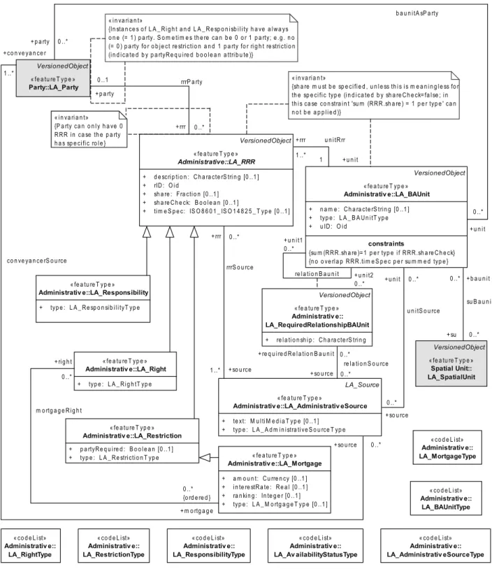
The main classes of the Administrative Package are basic classes LA_RRR and LA_BAUnit. See Figure 4.
LA_RRR is an abstract class with three specialization classes:
1) LA_Right, with rights as instances. Rights are primarily in the domain of private or customary law.
Ownership rights are generally based on (national) legislation, and code lists in the LADM are in support of this, see Annex J.
2) LA_Restriction, with restrictions as instances. Restrictions usually "run with the land", meaning that they remain valid, even when the right to the land is transferred after the right was created (and registered). A mortgage, an instance of class LA_Mortgage, is a special restriction of the ownership right. It concerns the conveyance of a property by a debtor to a creditor, as a security for a financial loan, with the condition that the property is returned, when the loan is paid off.
3) LA_Responsibility, with responsibilities as instances.
Licensed by INDECOPI to CTN Información geográfica y geomática - Dr. Jorge Lescano Instances of class LA_BAUnit are basic administrative units (abbreviated as baunits). Baunits are needed,
among other things, to register ‘basic property units’, which consist of several spatial units, belonging to a party, under the same right (a right shall be 'homogeneous' over the whole baunit). RRR shall be unique for each baunit in order to establish a unique combination between an instance of LA_Party, an instance of a subclass of LA_RRR, and an instance of LA_BAUnit.
Administrative::
LA_RRR
Administrativ e::
LA_Right
Administrativ e::
LA_Restriction Administrativ e::
LA_Responsibility
Administrativ e::
LA_Mortgage Administrativ e::
LA_Administrativ eSource Administrativ e::
LA_BAUnit Administrativ e::
LA_RequiredRelationshipBAUnit
Figure 4 — Classes of Administrative Package
In principle, all rights, restrictions and responsibilities are based on an administrative source, as instances from class LA_AdministrativeSource.
Class LA_RequiredRelationshipBAUnit allows for creating instances of relationships between baunits.
Relationships can be legal, temporal, or of a spatial nature.
5.5 Spatial Unit Package
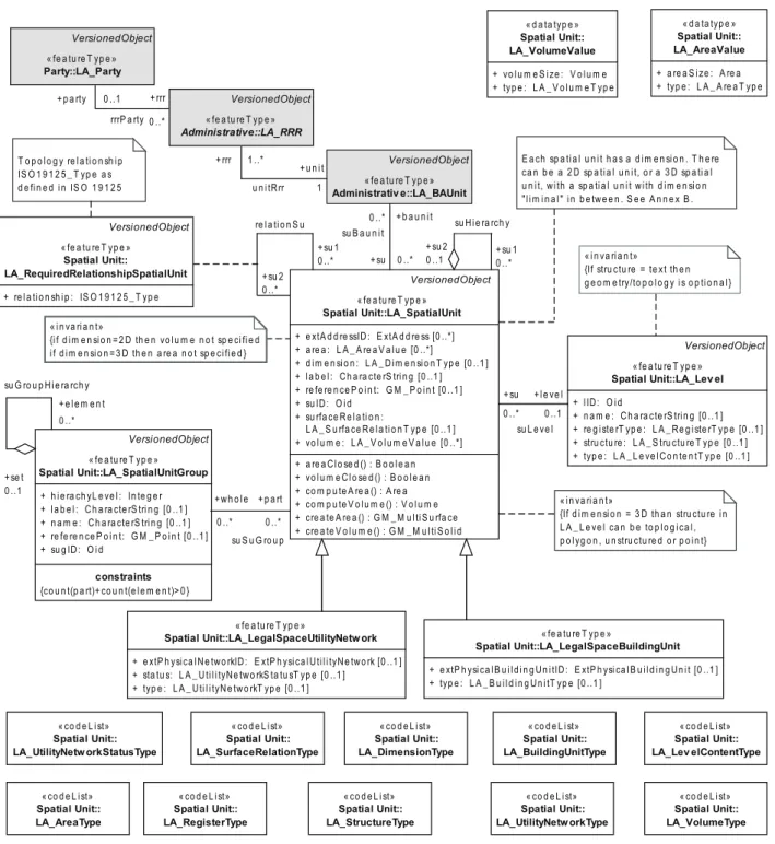
5.5.1 The main class of the Spatial Unit Package is the basic class LA_SpatialUnit, with spatial units as instances. LA_Parcel is an alias for LA_SpatialUnit, see Figure 5.
Spatial Unit::(LA_Parcel) LA_SpatialUnit Spatial Unit::
LA_RequiredRelationshipSpatialUnit
Spatial Unit::
LA_SpatialUnitGroup
Spatial Unit::
LA_LegalSpaceBuildingUnit Spatial Unit::
LA_LegalSpaceUtilityNetw ork
Spatial Unit::
LA_Lev el
Figure 5 — Classes of Spatial Unit Package
Licensed by INDECOPI to CTN Información geográfica y geomática - Dr. Jorge Lescano 5.5.2 Spatial units may be grouped into two forms:
1) as spatial unit groups, as instances of class LA_SpatialUnitGroup. Spatial unit groups can be further grouped into larger spatial unit groups. This is realised by an aggregation relationship of LA_SpatialUnitGroup onto itself, see Figure 5. An example of a spatial unit group is a municipality. A spatial unit group may be a grouping of other spatial unit groups. In the implementations of the LADM, this is to enable the inclusion of spatial unit identifiers in hierarchical zones.
2) as sub spatial units, or subparcels, that is a grouping of a spatial unit into its parts. This is realized by an aggregation relationship of LA_SpatialUnit onto itself, see Figure 5. Parts, in their turn, may be grouped into subparts (sub subparcels), and so on.
5.5.3 Spatial units are refined into two specializations:
1) building units, as instances of class LA_LegalSpaceBuildingUnit. A building unit concerns legal space, which does not necessarily coincide with the physical space of a building.
2) utility networks, as instances of class LA_LegalSpaceUtilityNetwork. A utility network concerns legal space, which does not necessarily coincide with the physical space of a utility network.
5.5.4 An instance of LA_Level is a level.
5.5.5 Required relationships are explicit spatial relationships between spatial units, and instances of class LA_RequiredRelationshipSpatialUnit. Sometimes there is a need for these explicit spatial relationships, when the geometry of the spatial units is not accurate enough to give reliable results, when applying geospatial overlaying techniques (e.g. a building, in reality inside a parcel, is reported to fall outside the parcel; the same applies to the geometry of a right, e.g. an easement). Required relationships override implicit relationships, established through geospatial overlaying techniques.
5.6 Surveying and Representation Subpackage
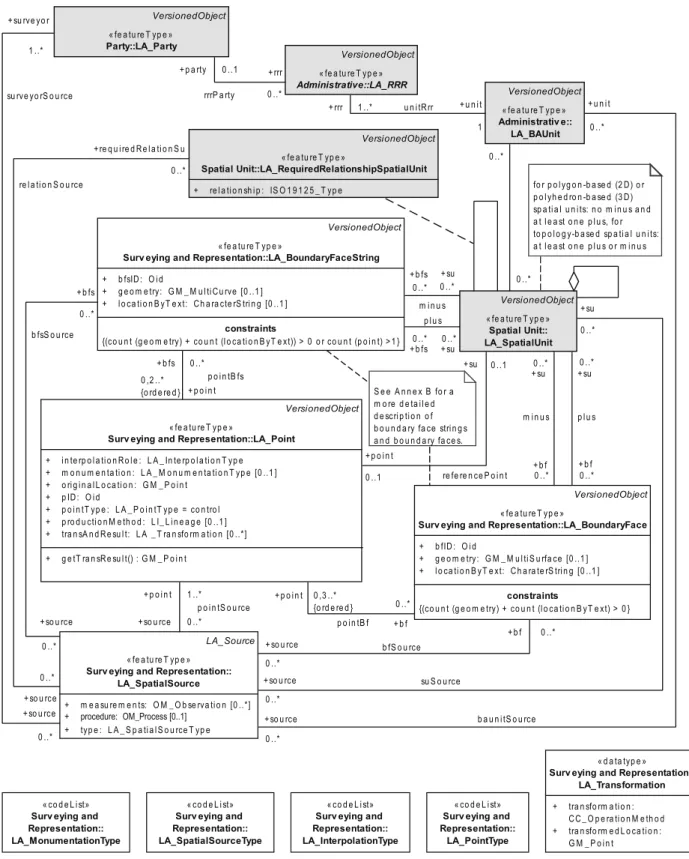
The four classes of the Surveying and Representation Subpackage are (1) LA_Point, (2) LA_SpatialSource, (3) LA_BoundaryFaceString, and (4) LA_BoundaryFace, see Figure 6.
Surv eying and Representation::
LA_BoundaryFace Surv eying and Representation::
LA_BoundaryFaceString
Surv eying and Representation::
LA_Point
Surv eying and Representation::
LA_SpatialSource
Figure 6 — Classes of Surveying and Representation Subpackage
Points, as instances of LA_Point, lines and surfaces can be acquired in the field (with classical surveys, or with GNSS), in an office, or compiled from various sources, for example using forms, field sketches, ortho- images or orthophotos. The acquisition of points, lines or surfaces (a survey) may concern the identification of spatial units on a photograph, on an image, or on a topographic map; cycloramas or pictometry methods (multiple images from different angles) may also be used for that purpose.
Licensed by INDECOPI to CTN Información geográfica y geomática - Dr. Jorge Lescano A survey is documented with spatial sources, instances from class LA_SpatialSource. This may be the final
(sometimes formal) documents, or all documents related to a survey. Sometimes, several documents are the result of a single survey. A spatial source may be official, or not (i.e. a registered survey plan, or an aerial photograph). Paper based documents (which may be scanned) can be considered as an integral part of the land administration system.
The individual points are instances of class LA_Point, which is associated to LA_SpatialSource. While it is not required that the complete spatial unit is represented, a spatial source may be associated to several points.
Geodetic control points, including multiple sets of coordinates for points, and with multiple reference systems, are all supported in the LADM.
2D and 3D representations of spatial units use boundary face strings as instances of class LA_BoundaryFaceString, and boundary faces as instances of class LA_BoundaryFace.
Coordinates themselves either come from points, or are captured as linear geometry.
The LADM supports the increasing use of 3D representations of spatial units, without putting an additional burden on the existing 2D representations. Another feature of the spatial representation within the LADM is that there is no mismatch between spatial units that are represented in 2D and spatial units that are represented in 3D. See Annex B for more details. The LADM is based on accepted and available spatial schemata, such as that published in ISO 19107:2003.
6 Content of classes of the LADM and their associations
6.1 Introduction
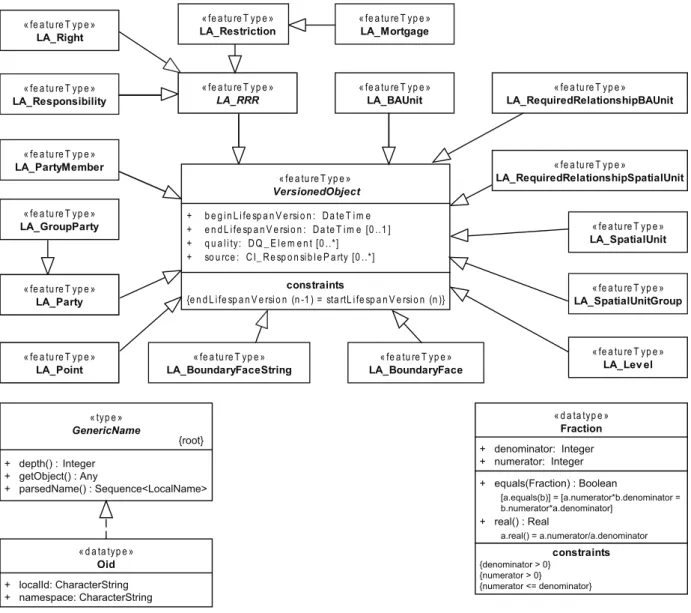
All LADM classes adhere to ISO/TS 19103 stereotype class featureType (a feature type is a class of features, i.e. abstractions of real world phenomena, having common properties). Many LADM classes are subclasses of class VersionedObject (see 6.2.1).
The LADM presupposes stereotype classes, with a minimal number of attributes, to address the situation where an LADM class refers to external sources for parties, addresses, taxations, land uses, land covers, valuations, building units, utility networks, or archives. See Annex K.
The LADM allows user-defined elements to be added. It is likely that additional attributes, operators, associations, or perhaps new classes, will be needed for a specific region or country. It is possible that parts of the LADM are not used. Therefore, country profiles can be used for customizing the LADM, to meet specific needs. See Annex D.
6.2 Special classes
6.2.1 VersionedObject
Class VersionedObject is introduced in the LADM to manage and maintain historical data in the database.
History requires, that inserted and superseded data, are given a time-stamp. In this way, the contents of the database can be reconstructed, as they were at any historical moment. For more on history and dynamic aspects of LA systems, see Annex N.
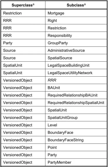
Classes LA_Party, LA_PartyMember, LA_RRR, LA_BAUnit, LA_SpatialUnit, LA_SpatialUnitGroup, LA_RequiredRelationshipSpatialUnit, LA_RequiredRelationshipBAUnit, LA_Level, LA_BoundaryFaceString, LA_BoundaryFace, and LA_Point are all subclasses of class VersionedObject, see Figure 7.
Classes LA_GroupParty, LA_Right, LA_Restriction, LA_Responsibility, LA_Mortgage (via LA_Restriction), LA_LegalSpaceUtilityNetwork and LA_LegalSpaceBuildingUnit inherit VersionedObject through the above classes.
Licensed by INDECOPI to CTN Información geográfica y geomática - Dr. Jorge Lescano
« fe a tu re T yp e » LA_Party
« fe a tu re T yp e » LA_RRR
« fe a tu re T yp e » LA_BAUnit
« fe a tu re T yp e » VersionedObject + b e g i n L i fe sp a n V e rsi o n : D a te T i m e + e n d L i fe sp a n V e rsi o n : D a te T i m e [0 ..1 ] + q u a l i ty: D Q _ E l e m e n t [0 ..*]
+ so u rce : C I_ R e sp o n si b l e P a rty [0 ..*]
constraints
{e n d L i fe sp a n V e rsi o n (n -1 ) = sta rtL i fe sp a n V e rsi o n (n )}
« fe a tu re T yp e » LA_SpatialUnit
« fe a tu re T yp e » LA_BoundaryFace
« fe a tu re T yp e » LA_BoundaryFaceString
« fe a tu re T yp e » LA_Lev el
« fe a tu re T yp e » LA_Mortgage
« fe a tu re T yp e » LA_Point
« fe a tu re T yp e » LA_SpatialUnitGroup
« typ e » GenericName
+ depth() : Integer + getObject() : Any
+ parsedName() : Sequence<LocalName>
« fe a tu re T yp e » LA_RequiredRelationshipBAUnit
« fe a tu re T yp e » LA_GroupParty
« fe a tu re T yp e » LA_PartyMember
« fe a tu re T yp e » LA_Right
« fe a tu re T yp e » LA_Restriction
« fe a tu re T yp e » LA_Responsibility
« fe a tu re T yp e »
LA_RequiredRelationshipSpatialUnit
« d a ta typ e » Oid
{root}
+ localId: CharacterString + namespace: CharacterString
« d a ta typ e » Fraction + denominator: Integer + numerator: Integer + equals(Fraction) : Boolean
[a.equals(b)] = [a.numerator*b.denominator = b.numerator*a.denominator]
a.real() = a.numerator/a.denominator + real() : Real
constraints {denominator > 0}
{numerator > 0}
{numerator <= denominator}
Figure 7 — Classes VersionedObject (with subclasses) Fraction and Oid
The attributes of VersionedObject are:
⎯ beginLifespanVersion: Start time of a specific instance version;
Value type: DateTime, based on ISO 19108
Multiplicity: 1
⎯ endLifespanVersion: End time of a specific instance version;
Value type: DateTime, based on ISO 19103 Multiplicity: 0..1
⎯ quality: Quality of a specific instance version;
Value type: DQ_Element (type from ISO 19115) Multiplicity: 0..*
Licensed by INDECOPI to CTN Información geográfica y geomática - Dr. Jorge Lescano
⎯ source: Responsible organization of a specific instance version;
Value type: CI_ResponsibleParty (type from ISO 19115) Multiplicity: 0..*.
6.2.2 Fraction
Generic data type Fraction is introduced in the LADM to provide support for fractions, e.g. ½ or ¾. A fraction is written as a pair of numbers, the top number called the numerator and the bottom number called the denominator. A line usually separates the numerator and denominator, see Figure 7.
The attributes of Fraction are:
⎯ denominator: The bottom number in the notation of a fraction;
Value type: int
Multiplicity: 1
⎯ numerator: The top number in the notation of a fraction;
Value type: int
Multiplicity: 1
Value type of denominator shall be a positive integer value ≥ 0.
Value type of numerator shall be a positive integer value ≥ 0, and shall be lower than the denominator value.
6.2.3 Oid
Generic data type Oid is introduced in the LADM to provide support for object identifiers, see Figure 7.
The attributes of Oid are:
⎯ localId: Local identifier, assigned by the data provider;
Value type: CharacterString
Multiplicity: 1
⎯ namespace: Identifier for the data source of the spatial object;
Value type: CharacterString
Multiplicity: 1
The local identifier should be unique within the namespace, i.e. no other spatial object should carry the same identifier.
NOTE Country profiles can limit the set of characters to ensure compliancy with local standards (e.g. {“A”..”Z”,
“a”..”z”, “0”..”9”, “_”, “.”, “,”, “-“}, i.e. only letters from the Latin alphabet, digits, underscores, periods, commas, and dashes are allowed).
Licensed by INDECOPI to CTN Información geográfica y geomática - Dr. Jorge Lescano 6.2.4 LA_Source
In the LADM, administrative sources and spatial sources are modelled, starting with an abstract class LA_Source. LA_Source has two subclasses: (1) LA_AdministrativeSource (see 6.4.7), and (2) LA_SpatialSource (see 6.6.2), see Figure 8.
« fe a tu re T yp e » Administrativ e::
LA_Administrativ eSource + te xt: M u l ti M e d i a T yp e [0 ..1 ] + typ e : L A _ A d m i n i stra ti ve S o u rce T yp e
« fe a tu re T yp e » Special Classes::LA_Source + a cce p ta n ce : D a te T i m e [0 ..1 ]
+ a va i l a b i l i tyS ta tu s: L A _ A va i l a b i l i tyS ta tu sT yp e + e xtA rch i ve ID : E xtA rch i ve [0 ..1 ]
+ l i fe S p a n S ta m p : D a te T i m e [0 ..1 ]
+ m a i n typ e : C I_ P re se n ta ti o n F o rm C o d e [0 ..1 ] + q u a l i ty: D Q _ E l e m e n t [0 ..*]
+ re co rd a ti o n : D a te T i m e [0 ..1 ] + sID : O i d
+ so u rce : C I_ R e sp o n si b l e P a rty [0 ..*]
+ su b m i ssi o n : D a te T i m e [0 ..1 ]
« fe a tu re T yp e » Surv eying and Representation::
LA_SpatialSource
+ m e a su re m e n ts: O M _ O b se rva ti o n [0 ..*]
+ p ro ce d u re : O M _ P ro ce ss [0 ..1 ] + typ e : L A _ S p a ti a l S o u rce T yp e
« i n va ri a n t»
{i f n o l i n k to E xtA rch i ve th e n te xt i n L A _ A d m i n i stra ti ve S o u rce o r m e a su re m e n ts i n L A _ S p a ti a l S o u rce }
Figure 8 — Class LA_Source (with subclasses)
The attributes of LA_Source are:
⎯ acceptance: The date of force of law of the source by an authority;
Value type: DateTime, based on ISO 19108 Multiplicity: 0..1
⎯ availabilityStatus: The availability status of the source;
Value type: LA_AvailabilityStatusType
Multiplicity: 1
⎯ extArchiveID: The identifier of a source in an external registration;
Value type: ExtArchive Multiplicity: 0..1
⎯ lifeSpanStamp: The moment that the event, represented by the instance of LA_Source, is further processed in the LA system (this is the moment of endLifespanVersion of old instances, and the moment of beginLifespanVersion of new instances);
Value type: DateTime, based on ISO 19108 Multiplicity: 0..1
Licensed by INDECOPI to CTN Información geográfica y geomática - Dr. Jorge Lescano
⎯ maintype: The type of document;
Value type: CI_PresentationFormCode Multiplicity: 0..1
⎯ quality: The quality of the source;
Value type: DQ_Element from ISO 19115 Multiplicity: 0..*
⎯ recordation: The date of registration (recordation) of the source by the registering authority;
Value type: DateTime, based on ISO 19108 Multiplicity: 0..1
⎯ sID: The identifier of the source;
Value type: Oid
Multiplicity: 1
⎯ source: The responsible party of the source;
Value type: CI_ResponsibleParty Multiplicity: 0..*
⎯ submission: The date of submission of the source by a party;
Value type: DateTime, based on ISO 19108 Multiplicity: 0..1
NOTE 1 The fact that all different (public or private law) rights find their base in some kind of transacting document is represented by the association between LA_RRR and LA_AdministrativeSource. The party responsible for drafting the document is connected to the latter as ‘conveyancer’, ‘notary’, or ‘writer’ (see Figure 10).
NOTE 2 In some land administration systems, sources are required to perform the transactions but these are not archived afterwards. The registration itself then serves as such evidence.
6.3 Classes of Party Package
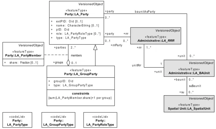
6.3.1 LA_Party
An instance of class LA_Party is a party. A party is associated to zero or more [0..*] instances of a subclass of LA_RRR. LA_Party is also associated to LA_BAUnit, to cater for the fact that a basic administrative unit can be a party (e.g. a basic administrative unit holding an easement on another basic administrative unit). A party may be associated to zero or more [0..*] administrative sources (i.e. the author of a transfer document is defined as a party playing the role of conveyancer in a source). A party may be associated to zero or more [0..*] spatial sources (i.e. the author of a survey document is defined as a party playing the role of surveyor in a source); see Figure 9.
Licensed by INDECOPI to CTN Información geográfica y geomática - Dr. Jorge Lescano VersionedObject
« fe a tu re T yp e » Party::LA_Party + e xtP ID : O i d [0 ..1 ]
+ n a m e : C h a ra cte rS tri n g [0 ..1 ] + p ID : O i d
+ ro l e : L A _ P a rtyR o l e T yp e [0 ..*]
+ typ e : L A _ P a rtyT yp e
VersionedObject
« fe a tu re T yp e » Administrative::LA_RRR
« fe a tu re T yp e » Party::LA_GroupParty + g ro u p ID : O i d
+ typ e : L A _ G ro u p P a rtyT yp e constraints
{su m (L A _ P a rtyM e m b e r.sh a re )= 1 p e r g ro u p }
« co d e L i st»
Party::
LA_PartyRoleType
« co d e L i st»
Party::
LA_GroupPartyType
« co d e L i st»
Party::
LA_PartyType
VersionedObject
« fe a tu re T yp e » Administrativ e::LA_BAUnit
VersionedObject
« fe a tu re T yp e » Spatial Unit::LA_SpatialUnit VersionedObject
« fe a tu re T yp e » Party::LA_PartyMember + sh a re : Fraction [0 ..1 ]
0 ..*
b a u n i tA sP a rty 0 ..*
+ p a rty 0 ..1
+ rrr 0 ..*
+ p a rti e s 2 ..* + rrr 1 ..*
+ u n i t 1
0 ..*
0 ..*
+ p a rty
+ rrrPa rty
+ u n i t u n i tRrr
+ b a u n i t
suBa u n i t + su
+ groups 0 ..1
members
Figure 9 — Content of Party Package and associations to other basic classes
The attributes of LA_Party are:
⎯ extPID: The identifier of the party in an external registration;
Value type: Oid
Multiplicity: 0..1
⎯ name: The name of the party;
Value type: CharacterString Multiplicity: 0..1
⎯ pID: The identifier of the party;
Value type: Oid
Multiplicity: 1
⎯ role: The role of the party in the data update and maintenance process;
Value type: LA_PartyRoleType Multiplicity: 0..*
Licensed by INDECOPI to CTN Información geográfica y geomática - Dr. Jorge Lescano
⎯ type: The type of the party;
Value type: LA_PartyType
Multiplicity: 1
NOTE If ‘role’ has a specific value (e.g. conveyancer) then it is possible that no subclasses of LA_RRR are associated to the party, hence [0..*] multiplicity, 0 indicating that, e.g. this conveyancer is not involved in any subclass of LA_RRR.
EXAMPLE Parties are demonstrated in instance diagrams, see Annex C, Figures C.3, C.4, C.13 and C.31.
6.3.2 LA_GroupParty
An instance of class LA_GroupParty is a group party. Class LA_GroupParty is a subclass of LA_Party, thus allowing instances of class LA_GroupParty to have an association with instances of class LA_RRR (and thereby also to class LA_BAUnit). A group party consists of two or more [2..*] parties, but also of other group parties (that is to say, a group party of group parties). Conversely, a party is a member of zero or more [0..*]
group parties, see Figure 9.
The attributes of LA_GroupParty are:
⎯ groupID: The identifier of a group party;
Value type: Oid
Multiplicity: 1
⎯ type: The type of a group party;
Value type: LA_GroupPartyType
Multiplicity: 1
LA_GroupParty has a constraint requiring that the sum of the shares of the group party members shall equal 1. This constraint is only enforced if a class LA_PartyMember exists (see 6.3.3).
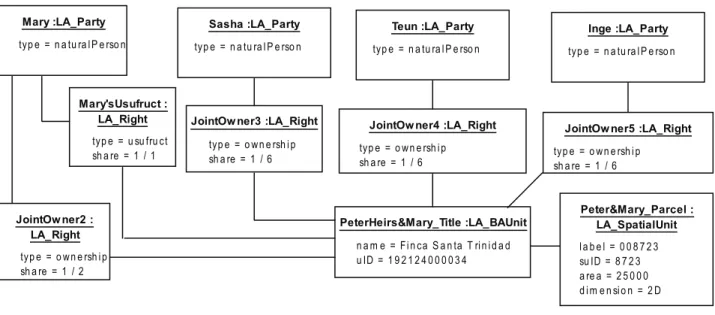
EXAMPLE Group parties are demonstrated in instance diagrams, see Annex C, Figures C.3, C.4, C.5 and C.26.
6.3.3 LA_PartyMember
An instance of class LA_PartyMember is a party member. Class LA_PartyMember is an optional association class between LA_Party and LA_GroupParty, see Figure 9.
The attribute of LA_PartyMember is:
⎯ share: The fraction of the whole;
Value type: Fraction Multiplicity: 0..1 6.3.4 Code lists for Party Package
Party Package has three code lists (see Figure 9). See Annex J for examples of the values.
⎯ LA_PartyRoleType: the LA_PartyRoleType code list includes all the various roles, such as surveyor or notary, parties may play in updating and/or maintaining the land administration in a specific land
Licensed by INDECOPI to CTN Información geográfica y geomática - Dr. Jorge Lescano administration profile implementation. The LA_PartyRoleType code list is required only if the attribute role
in LA_Party class is implemented. The code list shall provide a complete list of all codes with a name and description.
⎯ LA_GroupPartyType: the LA_GroupPartyType code list includes all the various types of group parties, such as association or family, recognized/allowed in a specific land administration profile implementation.
The LA_GroupPartyType code list is required to implement the LA_GroupParty class. The code list shall provide a complete list of all codes with a name and description.
⎯ LA_PartyType: the LA_PartyType code list includes all the various types of parties, such as natural or non natural persons, recognized/allowed in a specific land administration profile implementation. The LA_PartyType code list is required to implement the LA_Party class. The code list shall provide a complete list of all codes with a name and description.
6.4 Classes of Administrative Package
6.4.1 LA_BAUnit
An instance of class LA_BAUnit is a basic administrative unit. LA_BAUnit is associated to class LA_Party (a party may be a basic administrative unit). A basic administrative unit is associated to zero or more [0..*] spatial units. A basic administrative unit shall be associated to one or more [1..*] instances of right, restriction or responsibility (i.e. a basic administrative unit cannot exist if there is not at least one right, restriction or responsibility associated to it). A basic administrative unit can be spatially related, through a required relationship, to zero or more [0..*] other basic administrative units (i.e. create an explicit spatial relationship between two basic administrative units when the geometry is missing or inaccurate to provide reliable implicit results). Basic administrative units do not need to be related explicitly. However, if an explicit required relationship is specified, a basic administrative unit shall be associated to one or more [1..*] other basic administrative units. A basic administrative unit can be associated to zero or more [0..*] administrative sources (i.e. the basic administrative unit is usually described as the object affected by the right, restriction or responsibility in the administrative source). A basic administrative unit can be associated to zero or more [0..*]
spatial sources (i.e. the extent – part of – of a basic administrative unit can be described on a spatial source).
See Figure 10.
The attributes of LA_BAUnit are:
⎯ name: The name of the basic administrative unit;
Value type: CharacterString Multiplicity: 0..1
⎯ type: The type of the basic administrative unit;
Value type: LA_BAUnitType
Multiplicity: 1
⎯ uID: The identifier of the basic administrative unit;
Value type: Oid
Multiplicity: 1
LA_BAUnit has a constraint requiring that the sum of all the shares for one basic administrative unit shall equal 1 for the same subclass of class LA_RRR, unless ‘share’ is meaningless with regard to the type of right, restriction or responsibility. The constraint should be applied only to instances valid at the same moment in time (life span).
Licensed by INDECOPI to CTN Información geográfica y geomática - Dr. Jorge Lescano LA_BAUnit has a constraint requiring that no overlap be allowed between timeSpecs for the same RRR type
and the same basic administrative unit.
NOTE 1 LA_BAUnit allows the association of one right to a combination of spatial units (e.g. an apartment and a parking place).
NOTE 2 It is possible that no spatial unit exists for a basic administrative unit, thus allowing for the support of special administrative situations (e.g. deeds registration without mapping).
NOTE 3 With class LA_BAUnit it is possible to register spatial units from different levels as one unit. If (parts of) spatial units are included, or eliminated from the baunit, the uID stays the same, with a different version. In this approach, a mortgage can only be established on the complete baunit, not on one or more of the registered spatial units.
NOTE 4 A (group of) baunits may be a party.
EXAMPLE Basic administrative units (baunits) are demonstrated in instance diagrams, see Annex C, Figures C.1, C.17, C.24, C.25, C.26, C.28, C.30, C.31, C.33, C.34 and C.35.
Licensed by INDECOPI to CTN Información geográfica y geomática - Dr. Jorge Lescano
VersionedObject
« fe a tu re T yp e » Party::LA_Party
VersionedObject
« fe a tu re T yp e » Administrative::LA_RRR + d e scri p ti o n : C h a ra cte rS tri n g [0 ..1 ] + rID : O i d
+ sh a re : F ra cti o n [0 ..1 ] + sh a re C h e ck: B o o l e a n [0 ..1 ]
+ ti m e S p e c: IS O 8 6 0 1 _ IS O 1 4 8 2 5 _ T yp e [0 ..1 ]
« fe a tu re T yp e » Administrativ e::LA_Right + typ e : L A _ R i g h tT yp e
« fe a tu re T yp e » Administrativ e::LA_Restriction + p a rtyR e q u i re d : B o o l e a n [0 ..1 ] + typ e : L A _ R e stri cti o n T yp e
« fe a tu re T yp e » Administrativ e::LA_Responsibility + typ e : L A _ R e sp o n si b i l i tyT yp e
« fe a tu re T yp e » Administrativ e::LA_Mortgage + a m o u n t: C u rre n cy [0 ..1 ] + i n te re stR a te : R e a l [0 ..1 ] + ra n ki n g : In te g e r [0 ..1 ] + typ e : L A _ M o rtg a g e T yp e [0 ..1 ]
« i n va ri a n t»
{P a rty ca n o n l y h a ve 0 R R R i n ca se th e p a rty h a s sp e ci fi c ro l e }
« i n va ri a n t»
{In sta n ce s o f L A _ R i g h t a n d L A _ R e sp o n i sb i l i ty h a ve a l w a ys o n e (= 1 ) p a rty. S o m e ti m e s th e re ca n b e 0 o r 1 p a rty; e .g . n o (= 0 ) p a rty fo r o b j e ct re stri cti o n a n d 1 p a rty fo r ri g h t re stri cti o n (i n d i ca te d b y p a rtyR e q u i re d b o o l e a n a ttri b u te )}
« i n va ri a n t»
{sh a re m u st b e sp e ci fi e d , u n l e ss th i s i s m e a n i n g l e ss fo r th e sp e ci fi c typ e (i n d i ca te d b y sh a re C h e ck= fa l se ; i n th i s ca se co n stra i n t 'su m (R R R .sh a re ) = 1 p e r typ e ' ca n n o t b e a p p l i e d )}
LA_Source
« fe a tu re T yp e »
Administrativ e::LA_Administrativ eSource + te xt: M u l ti M e d i a T yp e [0 ..1 ]
+ typ e : L A _ A d m i n i stra ti ve S o u rce T yp e
« co d e L i st»
Administrativ e::
LA_ResponsibilityType
« co d e L i st»
Administrativ e::
LA_Administrativ eSourceType
« co d e L i st»
Administrativ e::
LA_MortgageType
« co d e L i st»
Administrativ e::
LA_RestrictionType
« co d e L i st»
Administrativ e::
LA_RightType
« co d e L i st»
Administrativ e::
LA_BAUnitType
« co d e L i st»
Administrativ e::
LA_Av ailabilityStatusType
VersionedObject
« fe a tu re T yp e » Administrativ e::LA_BAUnit + n a m e : C h a ra cte rS tri n g [0 ..1 ] + typ e :