The following pages are more in the nature of a preliminary report than an exhaustive description of the antiquities of the upper Verde River and Walnut Creek valleys. The purpose is to consider types and not to count many examples of the same type of wreck.

FEWKES] KUIXS ON THE UPPEK VEEDE RIVER 187 The buildings liercin considered have few points of likeness to New
RUINS ON THE UPPER VERDE RIVER
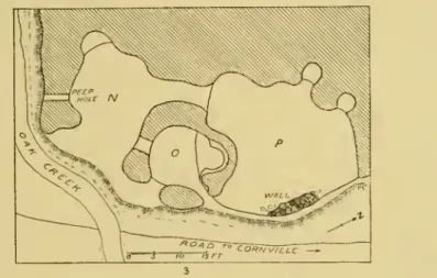
OAK CREEK CAVES
RUINS AT THE MOUTH OF OAK CREEK
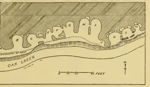
CAVATE ROOMS OVERLOOKING OAK CREEK
FEWKES] RUINS ON THE UPPER VERDE RIVER 189 suppose this structure to have been inhabited by people hostile to
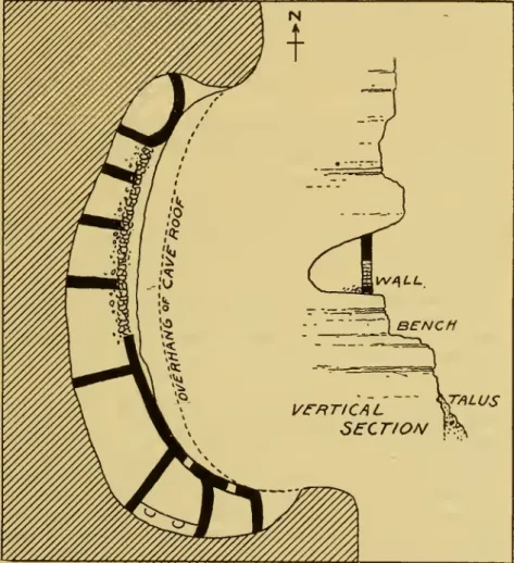
From the top of this talus to the level of the floors of the cavate chambers it is about 4.5 meters. At the edge of the cliff face, a shallow groove has been cut into the floor, which extends perpendicular to the edge of the cliff in which it is located.
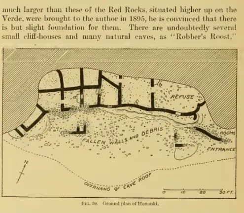
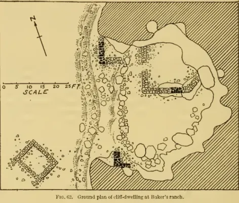
FEWKES] RUINS ON THE UPPER VERDE RIVER 195 The clifi'-dwelliags of the Rod Rocks, huilt aw they are in a rock
FEWKES] RUINS ON THE UPPER VERDE RIVER 195 The clifi'-dwelliags of the Rod Rocks, shrouded aw they are in a rock. Palatki(pis.85; 86,«) lies in the canyon east of Black's farm, a short distance away, and Honanki about the same distance to the west.

FEWKES] EUIXS OX THE UPPER VEEDE FIVER 197
28 of stone, but there are also fragments of adobe walls and sections of plastered mud floors attached to the ledges and adjacent parts of the bowls. Two or three beams project from the top of the bowl against the ledge, showing that the space between the bowl and the sides of the cliff was formerly floored, and the bottoms of the support beams rest on the bowl and on the edge. The floor appears to have been partly supported by a stone built into the cleft, the remains of which are shown on the plan.
A series of shallow pits cut into the surface and sides of the boulder occupy approximately the position indicated in fig. There are several similar ledge ruins in the VaUey, but the Jordan ruins are probably the best preserved. Several ruins of this type are found in the rocks below Montezuma Castle, as shown on Plate 79.
The Jordan Ruins are located in the cliffs on the right bank of the Verde, about 15 meters above the river bottom and can be reached by an easy climb over fallen stones. The soft limestone that makes up the cliff is here stratified, with the layers being slightly lithified and in places very strong. The largest of the Jordanian ruins (pis. 87, 88), with a length of 5.5 meters, extends approximately north and south.
TALUS
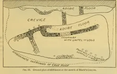
In Sycamore Canyon, about a milef at the junction of the Sycamore and Verde, a spring bubbles from the ground, the outlet of which formed a considerable stream at the time of the author's visit. This ruin is located in a cave in the side of the cliff, the access to it is worn out. the stones of the upper upper walls of the inner building are supported by vertical logs. About 2 miles from the junction of SycamoreCreek and Verde, on both sides of the canyon, even where the walls are steepest, are natural caves showing evidence of former habitation.^.
The formation of the chff in which the caves are situated is uniformly soft and spherical; the color is usually reddish, almost white. On a level place to the left of the road from Jeromeasone to the mouth of the Sycamore there is a pueblo ruin which very. Hell Canyon is a branch of Verde Canyon and the small stream that flows through the former discharges into the Verde, a short distance from the mouth of Granite Creek.
Owing to the fact that this ruin lies in the surveyed route of the proposed railroad from Cedar Grove to Jerome, most of its walls will have to be destroyed when the road is built. On the plain in front of the cave, between the talus and the river, are fallen walls of a small pueblo, from which many stones. The cave floor is covered with fallen stones in some of the places where the foundations of the remaining walls still rest.
SCALC
Although this cave is a natural formation, in the back areniches or cubbyholes appear to have been artificially excavated. Evidently this ruiii has been considerably dug over by relic seekers, for in the fine dust covering the floors is.
FEWKBS] KUINS ON THE UPPER VEBDE EIVEK 203
ERDE
204 ANTIQUITIES OF THE VERDE AND WALNUT CREEK [eth.anx.28 of Del Rio by following the bed of the Verde. From the river, the ruin approaches the appearance of a castle towering above and offering a view of the stream. The short axis of the ruin, measured from one end of the south wall to the other, is.
The distance between these structures from the south entrance is 87 feet, and from the nearest point in the north section, 6.5 feet.
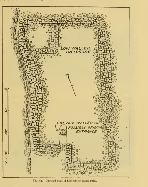
LIMESTONE BUTTE RUIN
LIMESTONE BUTTE (ABOVE' AND CORNVILLE RUINS
PEWKBS] LIMESTONE BUTTE KUIN 205 masonry, well preserved, averaging about 8 feet in height and 4\ feet
Below the western wall, the curve of which is shown in the accompanying Aaews (pis. 90, ca; 91, h), is a rough wall suggesting a cave chamber, while the other walls are unclearly marked. Viewed from the north, almost entire walls can be seen, the foundations of which in places are large projecting bowls.
RUINS ON WALNUT CREEK
OLD CAMP HUALAPAI AND MOUNT HOPE
VIEWS IN WALNUT VALLEY
FEWKES] BUINS ON WALNUT CKEEK 207 Structures and who are the descendants of the builders, are impor-
FEWKES] BUINS IN CKEEK ARRE 207The structures, and who are the descendants of the builders, are important-. Most writers on Arizona ruins do not refer to those found in this valley. This description does not correspond in size, height or general appearance to any ruins visited by the author in the region.
34;straight channel between high mountains," possibly the mouth of Bin Williams River, the mountains situated, as pointed out by Professor Turner, not far from the junction of this stream with the Colorado. To obtain a still more extensive view, Mr. hundred feet above the ridge of the pass, formed by a short]jur of the abruptter- .. closure of the northern chain of mountains, and found on the upper ruins of another A ruin supposed to be which so passes described, was visited by the writer, the results of whose observations, however, differ so much from Whipple's report as to suggest doubt as to the identity of the remains.
From Walnut Creek the old Indian trail followed by Wliipple ascends Aztec Pass, becoming a rough wagon road bordering gran-. West of the pass the country is relatively level and slopes gradually to a sheep farm on the Baca Grant, called Oaks and Willows. The high mountain seen from the road for some distance west of Aztec Pass is called Mount Hope (pi.
VIEWS IN BIG BURRO CANYON
FEWKES] RUINS ON WALNUT CREEK 209 Oaks and Willows, keei)ing this mountain on the right, a fairly clear
FEWKES] RRUNS ON THE WALNUT ROAD 209 Oaks and willows, keeping this mountain on the right, quite clear. Although, as usual, fragments of skeletons are supposed to belong to giants, the few bones examined by the author were of the same size and general characters as those found in the southwest. Shook's house and on the bay-avel of the river terrace not far from the residence of Mr.
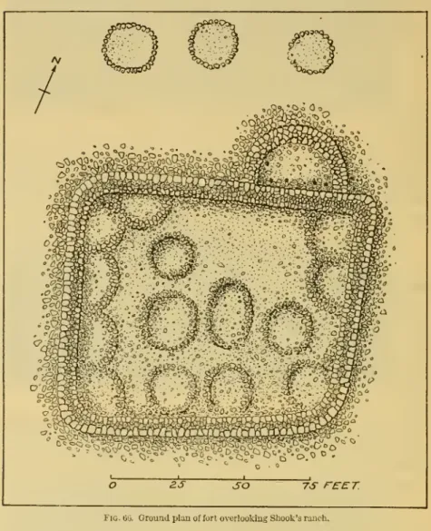
William Johnson's ranch house on the road to Drew's ranch, on a riglit bank, rises a steep rise 100 feet high, on which is the best preserved fort on Walnut Creek. This is probably the "pueblo" mentioned by Whipple, perhaps one of the structures that gave PuebloCreek its name. The fort offers views up and down the valley from Aztec Pass to the fort near Shook's Ranch and beyond.
The accompanying illustrations (pis. 95-97) show the present appearance of this form and the slope of the chasm from the side toward WalnutCreek; because of the trees on top of the ruin is. The walls are oriented east and west (fig. 65), the northern and southern sides are longer. Although apparently rectangular in outline, the north side, at 80 feet long (inside), is 5 feet longer than the south side.
TERRACE-RUINS IN WALNUT VALLEY
WALNUT VALLEY RUINS
FEWKES] RUINS ON WALNUT CREEK 211 where the entrances to the inclosure were situated, only a few stones
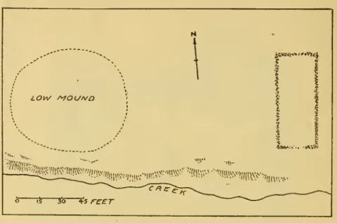
FEWKES] RUINS ON WALNUT CREEK 211 where the entrances to the enclosure were, only a few stones. Fallen walls within the enclosure indicate the former presence of many buildings, some circular in shape. Stone rings, averaging 16 by 13 feet in diameter, are found just outside the fort, on the side facing the river, where the ground is level.
FEWKES] RUINS ON WALNUT CREEK 213
The numerous fragments of pottery strewn on the ground outside the walls are evidence that this structure was occupied for a considerable period; it functioned both as a defense post and as a permanent residence. A ruined fort (pis. 85, 100) is located on a low limestone hill a short distance from the right bank of the river, where the valley widens slightly before flowing into the Chino Valley. Due to the flat nature of this region, the fort is visible from a considerable distance from any direction.
The walls, which are more or less dissected, cover the entire top of the hill. While much of the walls of the rooms within the enclosure have fallen, so that they cannot be well traced, a considerable portion still remains, forming near the gate what appears to be an entrance. There are many forts and ruins of river terraces on the Agua Fria and other streams which lead into the mountains around Pi'escotto and empty into the Salt and Gilo.
The walls here have fallen to such an extent that it is almost impossible to trace the ground plan of the ruins. One of the most impressive of these is on the right of the road to Glenilale, on an overturning of rocks on the tops of which the sides are surrounded by many. Each locality has a place of habitation and a fortified place of refuge in case of attack—the two essential features of antiquity.
CONCLUSIONS
Near a farm about a mile away are many mounds, apparently the remains of houses and enclosure walls, showing the former existence of a stone enclosure, resembling a compound.
TRINCHERAS AT FROG TANKS RUIN3
No traces of this construction have been found at the bowlder-marked sites, perhaps because no excavations took place. The similarities of forts and associated dwellings of the Upper Verde and Walnut Canyon with those around Prescott, on Granite Creek, the Hassayampa, Agiia Fria, and in other valleys of northern and central Arizona, and with similar structures in the valleys of the Gila and Salt and their tributaries, led the aiithor to incorporate the structures of the former group into a cultural area that reached. These people, the ancestors of the so-called Patld clans of modern Hopi, followed the Tonto and Verde rivers during their northern migrations.
The general features of the frlncheras on Walnut Creek and the ujjper Verde indicate similar structures that overlie the valleys of the Gila and Salt. It seems that the dwellings of these people belong to a special type that is distinct from the compact community houses or pueblos. still represented among the Hopi, the Zuni, and the numerous Pueblos of the Rio Grande, though identical with some ancient houses in. It is not strange if some of the descendants of tribes that formerly populated this area merged with the Hopi.
Both types may possess buildings above or in front of them, where in the first case the cave became a store-room, in the latter a back chamber,]) possibly devoted to ceremonies. A similar duality in cave-dwcUings occurs in the case of .. some of the larger rock houses, which e.g. those in the Canyon de CheUy. This duality is ])arallcl with that existing in the forts and rancherias or terraces (bowlders) on Walnut Creek.