A Discussion on the relationship between prominent unconformities on the SCS shelf margins and the end of seafloor spreading in the South China Sea
Franz L. Kessler1, #, John Jong2
1Ge ol og is t an d G e op h ys i cis t, T ra in e r, G lattb ach G er man y
2J X Nip p on an d G as E xp l orat ion (M alays ia ) L i mit ed , KL, Ma lay s ia
#Corresponding author: [email protected]
ABSTRACT
In an effort to reconcile different data sources (seafloor spreading, seismic and gravity images, well calibrations, outcrop studies) in the South China Sea (SCS), we reviewed the unconformity records, in particular in the context with the shut-off of seafloor spreading in the SCS. With respect to the start of spreading, there is a consensus: ca.
34-41 Ma. Recent data infer an end of spreading, near to the magnetic Anomaly 5 = ca. 15.5 Ma (Langhian age). In Northwest Borneo, it is suggested that this event is coeval with the Deep Regional Unconformity (DRU) in Sabah and Brunei, and the Mid- Miocene Unconformity (MMU) in Sarawak. The MMU is also recognized in offshore Vietnam and Palawan, on the Western and Southeastern margins of the SCS, respectively. The MMU/DRU may constitute the border between active margin and passive margin deposits within the marine SCS sub-basins. The progradation of clastic shelves post-MMU/DRU may have hampered growth of bioherms whilst creating prolific sandstone reservoir sequences offshore Northwest Borneo and Vietnam.
Keywords: DRU, MMU, SCS, spreading, unconformities, Middle Miocene, polarity reversal, paleomagnetism, Northwest Borneo
Copyright ©2023. FOSI. All rights reserved.
Manuscript received: 19 Nov 2022, revised manuscript received: 7 Feb 2023, final acceptance: 5 Mar 2023.
DOI: 10.51835/bsed.2023.49.1.396
INTRODUCTION: SCS
UNCONFORMITIES, ONSET AND TERMINATION OF SEAFLOOR SPREADING
The objective of this paper is to compare different data sources: well data, seismic imaging, gravity, magnetic polarity reversal results, outcrop data, etc., in the context of major shelfal unconformities as well as the observed spreading records in the South China Sea (SCS). We attempted to find evidence for a coeval timing of the Mid-Miocene Unconformity (MMU) and the end of spreading in the center of the SCS.
On the Northwest Borneo shelf, several unconformities appear to indicate dramatic shifts in the tectonic and sedimentary setting of the SCS. It is an area of apparent high geological complexity, and there are still different opinions what caused the rifting in the first place – a subject which lies beyond the scope of this paper, with authors such as C.S Hutchison (2004) interpreting the SCS being formed as a result of the rifting of the continental Sundaland lithosphere. At the end of seafloor spreading, no more oceanic crust was formed at the seafloor spreading center of the SCS. The end of spreading also prompted changes of
sedimentary deposition and tectonic patterns on the shelves including faults and lineaments. Noted in most regions, shelf areas prograded seaward towards the center of the basin.
Older publications often cite an earlier onset of rifting and a later shut-off.
According to Hutchison (2004), “rifting began in the Eocene (∼46 Ma) and ceased at 19–21 Ma (Anomaly 6), where seafloor spreading began much later than along the shelf of China”. The break-up hiatus lasted ∼3–5 Myr marked by the MMU and is also preserved onshore Sarawak. The post- rift strata date from ∼16 Ma and drape over the rifted topography. To the east is a convergent margin that became a collision zone in the Middle Miocene.
Interestingly, there is no reasoning given for the long duration of the “break-up”
hiatus.
The term “MMU” was thought to be first coined by Shell geologists and seismic interpreters in the Baram Delta of Sarawak, and neighboring Brunei.
However, there was no noted mention of the MMU in the 1970’s and 1980’s, which at the time discussions were still centered around the “Cycle”
transgressions and regressions (Ho, 1978; Doust, 1981), rather than tectonic
causes. Doust (1981) mentioned the early Middle Miocene as the start of rapid subsidence, albeit there was no reference to an unconformity. The first publication with the mentioning of MMU was believed to be by Mohd Idrus et al.
(1995), in which the unconformity and structure of deepwater Sarawak were described, and later summarized by Madon et al. (2013). “DRU” on the other hand, was well defined and described by Levell (1987), based on Sabah Inboard seismic data.
An unconformity, being related to the end of seafloor spreading, would be a dividing line within the passive margin setting, and describe a trend leading from deeper marine to increasingly shallow marine sediments (e.g. Kessler and Jong, 2015, 2016). The end-of- spreading unconformity may define the boundary between bathyal and neritic in the central SCS, and between neritic and shelf deposits on the flanks. One would expect a marked and erosive unconformity at the basin flanks, and a
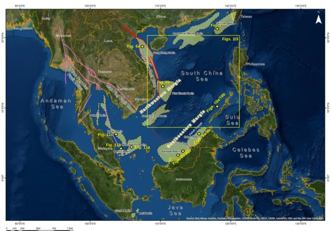
Figure 1: Area index map – satellite imagery of SE Asia. Key SCS Sub-basins that originated during the Paleogene are shown in black dashed line with light green fill (from Kessler et al., 2021b). The areas of oceanic crust and strongly thinned continental crust flanks are potentially bounded by the red line Red River Fault System, and the West Baram Line (WBL) (Jong et al., 2014; Kessler and Jong, 2016). Note Figures 2 and 3 are outlined in the yellow box area, while the approximate locations of key seismic lines are indicated by the yellow stars with the relevant figure numbers annotated.
Figs. 2/3 Fig. 6a
Fig. 6b
Fig. 7
Fig. 11a Fig. 11b
Fig. 11c
disconformity in the basial setting.
Supposedly such an unconformity might be an event of a diachronous nature but by only little.
In a previous publication (Kessler and Jong, 2016), we gave examples of the observed unconformities, which are seismically defined features and often poorly calibrated by well and outcrop data. However, unconformities are coined in individual sub-basins, and correlations between the SCS sub- basins are spurious. Therefore, this and the many data gaps have prevented establishing a clear context between SCS unconformities and seafloor spreading. Nevertheless, despite the mentioned correlation and data gap problems, we discuss which regional unconformities observed on the shelves might be coeval with the end of seafloor spreading.
The correlation of shelfal sequences with the center of the SCS could be important in the context of regional basin evolution and modeling. In the discussions below, we briefly review areas of the Central SCS, the Northwestern SCS shelf margin (Southern China, Vietnam, Gulf of Thailand, Malay and Penyu basins), and the Southeastern shelf margin (NW Borneo - Sarawak, Sabah and Palawan, Figure 1).
It is noted that a recent paper by Deng et al. (2020) has provided an excellent documentation on the transition from wide continental rift to continental breakup of the SCS.
METHODOLOGY, DATA SOURCES, AND DATA LIMITATIONS
In our investigation, timing of unconformity events such as the MMU and DRU are put in context with well and outcrop records and compared with magnetic polarity reversal ages of deep- sea drilling results recorded in the center of the SCS. In respect of the data collection, we considered the following sources in our synopsis:
(i) Well data. These can be categorized as shelfal wells, drilled in the context of oil and gas exploration, and several vintages of research wells, located in the center of the SCS. However, only data fragments of O&G wells have been released to the public. On the contrary, deep-sea drilling results are in the public domain, but given their position in the center of the SCS, the penetrated sedimentary record is limited and a direct link with unconformities on the shelf cannot be achieved.
(ii) Seismic data. Like the well records, we see ample and excellent industry data (often 3D) acquired on the shelves,
and 3D reconnaissance seismic (mostly 2D) in the center of the SCS.
Nonetheless, seismic lines, which both image shelfal and deepwater areas, are rare.
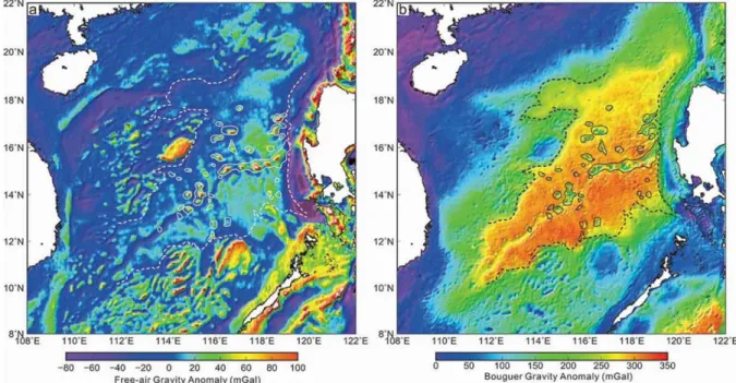
(iii) Gravity (Figure 2). Gravity data in the public are Free Air Gravity and Bouguer Gravity data. Free Air Gravity can be used to map the outlines of SCS topography, as it reflects mainly the impact of water depth. Bouguer data are very useful in highlighting variations in the crustal architecture (Figure 2b) and in the sedimentary overburden but contain elements of digital filters which may be based on assumptions only.
(iv) Magnetic polarity reversal data.
These can be recorded only over magmatic crust with little or no sedimentary overburden, and interpretation of the reversal has often led to ambiguous results.
(v) Geological outcrops. Outcrop interpretations can provide excellent data in respect of stratigraphy and describing the character of unconformities and their stratigraphic ties. This said, outcrops can give only one-dimensional answers to three- dimensional problems and should preferably be evaluated together with well and seismic controls.
Figure 2: (a) Free-air gravity anomaly map of the SCS basin (Sandwell et al., 2014) and (b) complete Bouguer gravity anomaly computed from (a) with the distribution of the post-spreading seamounts. Potential post-spreading seamounts in the SCS show free-air gravity anomalies of > 30 mGal and Bouguer anomalies of < 300 mGal, which is consistent with the observation by Zhao et al. (2018). Figures after Zhou et al. (2020).
See map outline in Figure 1.
A COMPARISON OF SCS SUB-BASIN AREAS
For discussion purpose, we subdivide areas surrounding the SCS as follows (Kessler and Jong, 2016; Kessler et al., 2021a, 2021b) (Figure 1):
• The Central SCS covers by far the largest part of the discussed topic.
Seismic coverage is sparse and irregular, and only a few research wells (ODP, IODP) provide rudimentary calibration points. The area is mostly constituted by deep marine settings, oceanic crust plus several remnants of rafted continental crust.
• The Northwestern shelf margin is formed by a string of sub-basins starting from Peninsula Malaysia to Vietnam margin to Hainan Island, and southern China. The well is well covered by seismic and numerous exploration wells.
• In the Southeastern shelf margin, we see several sub-basins located in the Borneo margin to Palawan Trough. As in the Northwestern margin, there is mostly good seismic coverage, and relatively good calibration by wells and outcrops fringing the tectonic border with the Rajang/Crocker Basin.
Eocene deposits in the area were described and discussed in Kessler et al. (2021a).
Central SCS area
The central SCS, a deep basin, has become the subject of scientific drilling research since 1999. Over the last 20 plus years, around 17 sites were drilled and nearly 10,000 m of cores recovered, including 320 m of basement basalt (Wang et al., 2019). The area is characterized by bathyal deepwater setting, with thin sequences of fine clastic deposits from Eocene to recent.
The published data comprehend gravity and magnetic data, regional 2D seismic grids, and several deep-sea drilling holes. Systematic geological exploration dates to the 1970’s when geophysical data – seismic, gravity and magnetic were acquired in the context of the deep- sea drilling campaigns and when the first extensional models were developed (Taylor and Hayes, 1980). These showed that there is a triangular-shaped area being underlain by oceanic crust, surrounded by the continental shelves and slopes of Hainan, Vietnam, the Philippines, and Borneo.
Figure 2 shows a broad Bouguer gravity anomaly coinciding with the center of the SCS and the area of seafloor spreading. The gravity data also allow distinction of the central SCS spreading area (in orange color), thinned continental crust (green color) and
mildly or unstretched crust elements with passive margin sedimentary cover (blue color).
A tabulation of magnetic data was compiled in Cande & Kent (1995) (Table 1). They showed a symmetrical pattern
of seafloor spreading, in the eastern part of the basin, indicating a spreading activity from Mid-Oligocene to Early Miocene (Hutchison, 1996). Although the mere fact of oceanic crust formation by seafloor spreading was never disputed, there is an ongoing discussion Figure 3: Magnetic polar reversal patterns shown by Childless et al. (2020) in Sun et al. (2020), as result of the IODP drilling program, leg 367/368. Note that the oldest reversal lines shown in the immediate vicinity of the mid-ocean ridge is the Anomaly 5c (on either side of the spreading centre). Black lines = ocean-bottom seismometer refraction data. Other seismic lines (orange) are mostly multichannel seismic reflection data. Yellow lines = magnetic isochrons from Briais et al. (1993). White stars = Expeditions 367, 368, and 368X drill sites. Red squares = ODP Leg 184 sites. Red circles
= IODP Expedition 349 sites. See map outline in Figure 1.
about when seafloor spreading started and when it ended.
Key concepts regarding the seafloor spreading in the SCS, discussed by various authors have been summarized by Kessler and Jong (2016); these include intrusion-based models (e.g., Tapponier et al., 1982; Replumaz and Tapponier, 2003), as well as subduction- based models (e.g., Taylor and Hayes, 1980; Briais et al., 1993; Hall, 2002;
Hall et al., 2008) and hybrid models (e.g., Cullen, 2010; Cullen et al., 2010).
However, when considered in detail, the data regarding the onset and termination of seafloor spreading appear less coherent, as shown in the summary by Morley (2016). One of the primary goals the deep-sea drilling projects in the SCS was to establish a “testing hypotheses for lithosphere thinning during continental breakup”, rather than establishing stratigraphic control in the basement rocks and in sediments overlying the magmatic oceanic crust. A great effort was made in recognizing and differentiating the hypothesis models for the formation of the SCS by using data from deep-sea drilling projects.
In the SCS, there is a pattern of several normal-to-reverse polarity switches that are relatively well aligned. The critical challenge is to identify the polarity reversal pattern and to assign correct
ages to both measured individual reversal points and the interpreted polarity reversal pattern. The magnetic polarity reversals happened at highly irregular intervals during seafloor spreading. However, polarity reversals have been mapped, catalogued, and correlated on a world-wide scale, and can offer fairly reliable time markers, if a good local calibration is achieved.
Nevertheless, the well results have delivered a few good absolute ages, as well as biostratigraphy data points in respect to the age of sediments overlying the magmatic oceanic crustal rock.
International Ocean Discovery Program Table 1: Polarity reversal events and tertiary ages. The SCS spreading shut- off uncertainty range is indicated by the red bar (from Cande and Kent, 1995).
Recent data suggest that the shutoff may have occurred close to Anomaly 5.
(IODP) Expedition 367 successfully recovered at Site U1500 the mid-ocean ridge basalt (MORB) representing the magma activity of the initial spreading of the SCS during the earliest Oligocene (Yu and Liu, 2020). From the other sites (U1431, U1433, U1146, U1147, U1148), only U1435 logged Paleogene sediments
at locations in proximity to the continental-to-oceanic crustal boundary (C.-F. Li et al., 2014; Figure 3). Most of the wells, however, were drilled in the central area of the SCS, where there is no continental crust that could host a Paleogene sediment cover, given that the oldest sediments found are (with one Figure 4: Litho-, bio- and magneto-stratigraphic and strontium isotope stratigraphic correlations at Site U1501. (a) Lithology; (b) depth-age plot of Site U150 based on the shipboard biostratigraphic data of calcareous nannofossils and planktonic foraminifera, magnetostratigraphic data and the Sr isotopic ages with numbers beside the lines indicate the average sedimentation rates. Red zigzag lines represent the unconformities, while T60 indicates the seismic reflector; (c) SEM photographs of index planktonic foraminifera including typical Late Eocene species. These data overall point to the Late Eocene start of seafloor spreading in Central SCS (from Jian et al., 2019).
exception) of Early to Mid-Miocene age.
Another IODP well, U1501 (Figure 3), penetrated Late Eocene rock on the northeastern shoulder of the central SCS rift (see Jian et al., 2019) (Figure 4).
Arguably one can pinpoint the onset of oceanic crust formation in the Late Eocene (?Priabonian, 34 – 41 Ma) or slightly older.
There seems to be less uncertainty in respect of the start of spreading, but significantly more for the termination of spreading. This may be related to
varying interpretations with respect to the measured and interpreted polarity reversals. Barckhausen et al. (2014) interpreted the most recent polarity reversal located near the axis of spreading as Anomaly 6, whilst more recent interpretations by Childless et al.
(2020) and summarized in Sun et al.
(2020) proposed a younger polarity reversal Anomaly 5 (Figure 3). Regarding the end of spreading, central SCS wells provide only some tangible information.
Chang et al. (2014), in a reply to
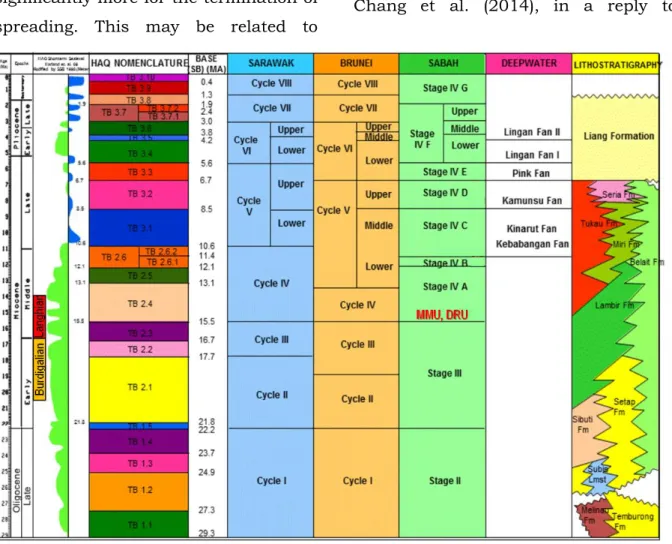
Figure 5: Simplified stratigraphic scheme of NW Borneo shelf margin showing correlation of the Sabah, Sarawak and Brunei cycles and stages with SB and TB nomenclatures, Shell deepwater terminology and lithostratigraphy. Note the Mid- Miocene Unconformity and Deep Regional Unconformity (MMU, DRU) are annotated at the base of TB2.4 at around 15.5 Ma (from Morrison and Wong, 2002).
Barckhausen et al. (2014) argued that a bio-stratigraphically determined age of 16.7 to 17.5 Ma, was obtained from a borehole close to the spreading center of the SCS and appeared to point to a Mid- Miocene age for the end of spreading, instead of Early Miocene (20.5 Ma), as proposed by Barckhausen et al. (2014).
This way they could extrapolate the results to the ridge and conclude, that the spreading was still ongoing at least until 17.5 Ma but probably later, and hence pointed to a Burdigalian- Langhian age as the end of spreading (Figure 5).
Northwestern shelf margin
This area corresponds to the Gulf of Thailand and offshore peninsular Malaysia, as well as contemporaneous shelf areas of Thailand, Vietnam and southern China.
The Vietnam to Southern China shelf margin is characterized by predominantly shelfal settings with several isolated and deeper sub-basins.
The Vietnam continental shelf area lies above a system of Cenozoic sub-basins within a transition zone leading from the Figure 6a: Seismic section of Song Hong depocentre with SB4 equivalent to MMU and SB2 is likely Late Oligocene unconformity/BMU. There is a clear division in a pre-MMU section (=active shelf margin) and a post-MMU section which is formed by passive margin deposits. From Unir and Mahmud (2006) with location map from Fyhn et al.
(2012). See approximate line location in Figure 1.
continental crust of the Indochina Block to the sub-oceanic crust of the eastern deepwater basins.
These basins developed here are rift basins with multiphase history as summarized by Fyhn et al. (2009b, 2012) (Figures 6a and 6b). As
summarized in Clift et al. (2002) and Morley (2016), the strong extension and structural inversion largely pre-date the 16 Ma unconformity. The authors called this event MMU, following Hutchison (2004) (Figures 6a and 6b), and the post- rift strata were dated from ∼16 Ma and Figure 6b: a) Geo-seismic sections offshore Vietnam going through several wells and highlighting the major stratigraphic units with mapped MMU (light blue horizon) illustrated across the Phu Khanh Basin, dashed dark-blue line = Late Oligocene Unconformity/BMU. b) Syn-rift depocentre. c) Schematic summary of the play types of the Phu Khanh Basin. Modified after Choi and McArdle, 2015. See approximate line location in Figure 1.
draped over the older rifted topography.
To the east is a convergent margin that became a collision zone in the Middle Miocene. An extensional phase was initiated around 28 Ma, moderate extension is noted at 22–23 Ma. Normal faulting ceased after an inversion event at ca. 16 Ma, although, representing the end of basin extension, and indicating compressive stress. C.-F. Li et al. (2014) and L. Li et al. (2014) infer that faulting stopped at the unconformity (see Figures 6a and 6b), whilst the underlying Early Miocene section is faulted. 1D subsidence models indicate rapid “syn- rift” subsidence, possibly lasting until 10 Ma, despite the lack of observed extensional faulting (L. Li et al. 2014).
In contrast, Fyhn et al. (2009a, b) see the main termination of extension of the Vietnam Margin at the Lower Miocene – Oligocene boundary (i.e. 23-21Ma). Note the MMU features very clearly in the Nam Con Son and the southern Phu Khanh Basins (Fyhn et al., 2009a) (Figure 6b).
In the Late Miocene, the basin was again tectonically restructured by a mild inversion, followed by thermal subsidence, resulting in large carbonate reefal buildups, and infilled by sandy turbidites on the basin floor. The process was interrupted in the Early Pliocene due to a major transgression.
Further south in the Gulf of Thailand, Malay and Penyu basins, the margin is characterized by an embayment formed by thick non-marine and marginal marine sequences, where intertidal marine clastics and coals were deposited since the Early Miocene. Despite a continuous subsidence during the Neogene, the area remained covered by shallow marine water. There is no prominent unconformity signature noted at the Mid-Miocene time, nor is there any important facies change recognized (Madon et al., 1999, 2019;
see later Figure 11).
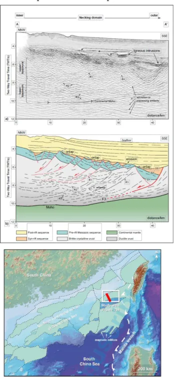
Admittedly not a focus area of our investigation, it is interesting to note that an additional complexity of the Northeastern SCS margin is the presence of a Necking Domain, as described by Mi et al. (2023). The most striking characteristic of the bended or flexed necking domain in the area is the densely spaced, landward-dipping faults and fractures that are organized in a domino configuration in the homogeneous basement. Seismic stratigraphy in the necking domain can be divided into pre-, syn- and post-rift sequences based on the nature of sequence-bounding unconformities and their relation with faults. Seismic expression of continental crust exhibits two types of reflection characteristics –
homogeneous upper crust and layered lower crust. In some shelfal areas, the necking has led to a tilting of both the syn-rift and post-rift sequence. A clear boundary between syn-rift and post-rift sequences can be interpreted (Figure 7), but whether this boundary is coeval with the MMU in other parts of the SCS, remains speculative at this point in time.
Southeastern shelf margin
This area covers the Sarawak-Sabah- Palawan margin, with Sarawak characterized by shallow shelf with many bioherms; shallow-marine clastic deposits in Baram Delta.
As suggested in Jong et al. (2014) and Kessler et al. (2021a, 2021b), the so- called Mid-Miocene Unconformity (MMU; Figures 8a-8d) might be a good candidate for an event for a correlation with the end of the SCS spreading. The Sarawak shelf is divided into the stable
Figure 7: Uninterpreted seismic section A-A’ (a) and its interpretation (b) showing detailed deformation of the necking domain (section location see bold red line in index map). F3 is the outer breakaway complex. S1, S2, and S3 are three unconformities that separate the top-basement, pre-rift, syn-rift, and post-rift sequences.
However, whether S3 is coeval with the MMU in other parts of the SCS, remains speculative at this point in time (S3=MMU?). R1, R2, and R3 are three types of reflectors in the basement. Note that the homogenous basement in the upper part of the necking domain is dominated by land- ward dipping reflections (R1) that are interpreted as fractures. R2 is sub- parallel to the top basement. R3 is sub-parallel to the seismic Moho. In the post-rift sequence, the high- amplitude, saucer-shaped and step- like reflections are interpreted as igneous intrusions (from Mi et al., 2023). See also the approximate line location in Figure 1.
Central Luconia Platform and the less rigid Baram Delta area.
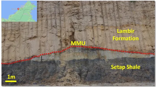
The unconformity is relatively well dated in the onshore Baram Delta deposits of Sarawak, and its age was identified as ca. 15.5 Ma in an outcrop of Bukit Lambir (Entulang section, Wannier et al., 2011), where it is seen to scour clay- dominated rocks of the Setap Shale (Kessler et al., 2019, Figures 8a and 8b);
the sediments underlying the unconformity are Burdigalian and contain further up a NN4-5 planktonic assemblage (assumed Langhian). The
hiatus at the unconformity was estimated as 0.5 Myr but may vary in other areas depending on scouring.
Future work may focus on reviewing the location of the MMU in SCS exploration wells and analyzing facies changes in the stratigraphic sequences located below and above the unconformity. In the adjacent Luconia Platform, the appearance of the MMU appears to be different, and may not be an unconformity in the traditional sense (van Vliet and Krebs, 2009).
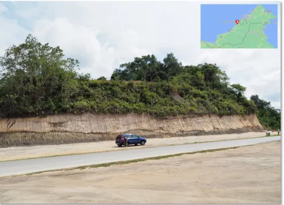
Figure 8a: View of the Mid-Miocene Unconformity (MMU) with a mid-size SUV for scale, located in Bukit Lambir (red mark in the inset map of northern Borneo), a large pop-up between two branches belonging to the West Baram Line system. The above outcrop is situated next to a highway construction site and is showing a rare example of a large- scale unconformity exposure. Cross-bedded Late Miocene Lambir sandstones are seen above scoured clay and siltstone of the Early-Mid Miocene Setap Formation (from Kessler et al., 2019).
Figure 8b: View of the Mid-Miocene Unconformity (MMU, red dashed line), road cut in Bukit Lambir, NW Sarawak. The unconformity is seen scouring Setap Shale, here formed by black shale and grey siltstone. Above the unconformity lies the sands of the Lambir Formation (from Kessler et al., 2019). The unconformity has been age-dated by Wannier et al. (2011), in an outcrop nearby assigning a tentative age of 15.5 Ma to the scoured clastics beneath the unconformity.
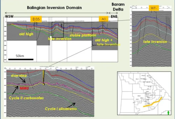
Figure 8c: Balingian Province to Baram Delta with inversion created broad anticlines that continued into the Pliocene with ggeneral thickening and deepening to the east. The MMU is approximately at Top Cycle II represented by a yellow horizon (from Kessler and Jong, 2016). See approximate line location in Figure 1.
The Sabah margin is characterized by a relatively narrow shelf-to-slope zone, with basinal sediments comprised of turbiditic deposits and pelagic shales.
The margin exhibits a complex relationship which the Rajang/Crocker hinterland. Unlike Sarawak shelf, there is no extension of SCS deposits in the onshore area, the outcropping sediments of the hinterland occupying
the onshore and a narrow band offshore belong to the anchi-metamorphic Rajang/Crocker system and are of Eocene or older age.
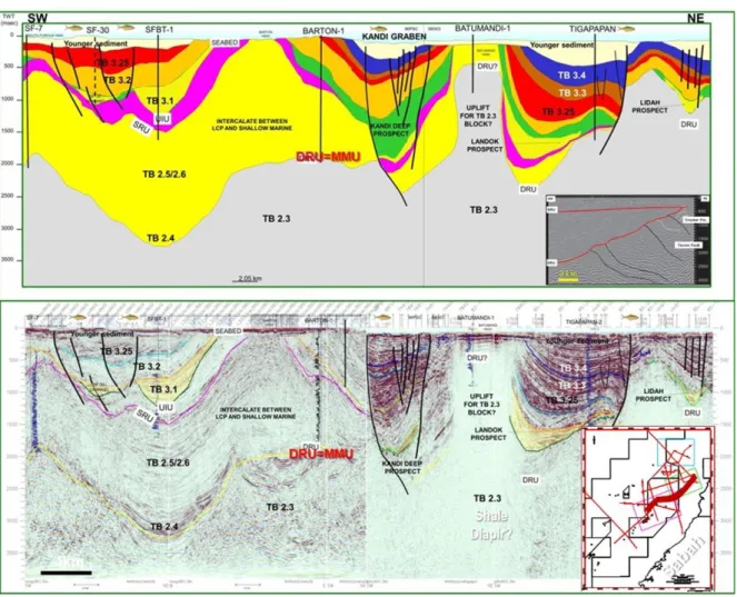
In the offshore Sabah Basin, we recognize “Deep Regional Unconformity”
the DRU (Levell, 1987, Figures 9a and 9b). This in seismic terms a widespread unconformity event has been calibrated Figure 8d: Seismic section immediately south of Central Luconia, showing the tightly compressed and eroded anticlines as a product of the Mid-Miocene Unconformity, MMU (Mat Zin and Tucker, 1999). The thrust-up and eroded anticlines have been commonly mistaken for horsts (Hutchison, 2005). (B) The cartoon suggests the cause of folding within the Balingian, Central Luconia and Miri zones, and could point to the location of the Sundaland Plate Margin located beneath the Rajang thrust belt. Modified after Hutchison and Vijayan (2010). Following the cessation of sea-floor-spreading (MMU/DRU), the progradation of shelfal clastics led to an environment less suitable for bioherm growth in large parts of Central Luconia. See approximate line location in Figure 1.
in a number of offshore Sabah wells and has been age-dated as TB 2.4 (Mid- Miocene, Langhian; Figure 5). The angular unconformity has been dated by some 19 exploration or appraisal wells and is closely constrained to occur within the Globorotalia peripheroacuta zone, i.e., “early Middle Miocene”. The G.
peripheroacuta zone was established by Blow (1969) and later became renamed N10 in his 1979 scheme (citation in Lunt and Madon, 2017).
The DRU separates a deeper, slope or basin setting, lean in sand from a younger and shallower, often deltaic sequence. Accordingly, this Sabah unconformity might be time-equivalent to the MMU in Sarawak (Figures 5 and 9a). However, Lunt and Madon (2017) claimed that the DRU was, by the nature of its outstanding magnitude, not only the unconformity associated with the end of seafloor spreading in the SCS but
Figure 9a: Regional composite 2D seismic line with mapped TB sequences from Sabah Inboard area showing areas of tremendous uplift, exhumation and amalgamated unconformities with development of mini basins between ridges. The inset seismic shown an example of DRU, which might correspond to the MMU (from Kessler and Jong, 2016).
See approximate line location in Figure 1.
has seen an overprint of other tectonic factors.
Summarizing the above, we recognize an important unconformity, the MMU in Sarawak, of Mid-Miocene, Langhian age, which is equally prominent along the Vietnam margin. Another unconformity in the neighboring Sabah waters, the DRU, appears to be roughly of the same age. This is based on O&G exploration wells in Sabah which penetrated the clay-dominated Stage III sequence, the latter underlying the post-DRU Stage IV sands. The coeval timing of the events is proposed as the end of spreading in the center of the SCS, which is about 15.5 Ma. Therefore, the MMU/DRU is seen as a major stratigraphic boundary in Sarawak and Brunei, separating Cycle IV from Cycle III, and also separating
Stage IV from Stage III in Sabah (Figure 9c). Ages aside, there is also discussion about the geological meaning of prominent unconformities, the MMU and the DRU. Although both events appear to be related to the SCS seafloor spreading, at least the DRU may also be Figure 9b: Seismic section in offshore Sabah near the St. Joseph Field. The DRU (purple marker) is the oldest mapped unconformity in this area. It separates a younger (post Mid- Miocene) shelf to slope setting from a deeper slop to basin setting lean in sand. The post- DRU/MMU setting is characterized by massive clastic deposits, at least partly caused by a significant uplift of the Rajang hinterland. See approximate line location in Figure 1.
Figure 9c: Outcrop in Limbang (with a geological hammer for scale), Limbang River Valley (red star in inset map) showing Stage III equivalent deposits in a sand-lean (slope?) distal turbidite facies.
This section is located immediately beneath the inferred DRU location.
affected by compression and mountain- building processes in NW Borneo and probably also Palawan.
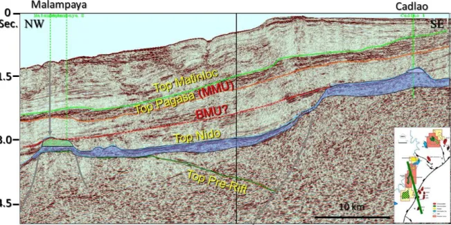
North of the Sabah margin, the Palawan margin is characterized carbonate-
clastic shelf with block-faulting above carbonate buildups (see Figure 10a). The Palawan margin indicates a development of a rifted sequence and carbonate growth on high areas, such as Malampaya (Steuer et al., 2014). There is a southeastward tilt indicating the uplift of Palawan Island. The main Mid- Figure 10a: Cross-section through the Palawan margin (after Steuer et al., 2014 and Kessler and Jong, 2016). Similar to Sabah, the Palawan hinterland saw uplift and tilting.
The post-MMU/DRU sequence points to a scoured and canyonized shelf/slope setting. See approximate line location in Figure 1.
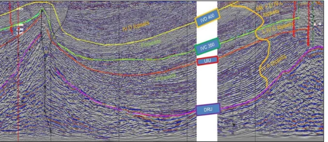
Figure 10b: NW-SE oriented 3D seismic line (in meter depth) in offshore SW Palawan (top) and its structural interpretation (bottom). Other structural features include: a 600 m-thick deformed sequence of lower Pagasa Formation, marking the onset of under thrusting of the Nido Limestone; a northwestward progressing front of the thrust-fold in the Pagasa Wedge; syn- thrust deposition above the top folds of the fold- thrust; MMU truncating the wedge, overlain by Tabon (Matinloc Formation) and Carcar Limestone (Quezon Formation) (from Aurelio et al., 2014). See approximate line location in Figure 1.
Neogene seismic unconformity is called the Red Unconformity dated at about 12–13 Ma (equivalent to the DRU of Sabah; Luan and Lunt, 2022). The MMU/DRU (or the Red Unconformity?) is draped over the older (Pre-Neogene) horst-and-graben setting and has led to some erosion on the high areas. This occurred when the uplift of a foreland overthrust system paused, and a locally erosional surface was rapidly transgressing.
Note according to Aurelio et al. (2014), the Pangsa Wedge, the thrust-fold belt built within the Mid-Miocene due to deformation of the Early-Middle Miocene
Pangsa Formation is truncated by the regionally observed MMU (Figure 10b).
MMU AND INVERSION TECTONISM
Inversion tectonics are seen in many areas of the Northwestern SCS.
Inversion tectonics occur at Cretaceous levels (Huang et al., 2017), such as at the Dongsha-Penghu Uplift of the Northwestern SCS continental margin.
Inversion tectonism is also prominently during the Cenozoic. There are inversion examples in Brunei’s Baram Delta (Morley et al., 2003) and the onshore greater Miri area (Kessler and
Figure 11: West Natuna-Malay-Penyu basins examples of inversion structures, (a) Seismic from HIS Markit of inverted basin in the West Natuna (Sunda Fold), (b) Seismic example of flower structures in the Penyu Basin driven by strike-slip faulting, and (c) Structure cross section of the Malay Basin with inverted anticlinal features from Mazlan et al. (1999). Figures compiled by Jong et al. (2014). See approximate line locations in Figure 1.
Jong, 2013, 2014). Madon et al. (1999, 2019) showed seismic examples of inversion tectonics from the Malay and Penyu basins. Miocene inversion is also cited by Jong et al. (2014, 2017) in the SCS with an inverted deep low called the Bunguran Trough, and well-noted in the adjacent Natuna Basin (Burton and Wood, 2010). Figure 11 compiled by Jong et al. (2014) shows some examples of inversion structures in the West Natuna-Malay-Penyu basins.
Inversion tectonics can be related to compression and perhaps a relatively mobile underlying basement, and inversion is in some areas (Malay and Penyu basins) related to strike/slip tectonism.
At this point, the authors do not see any obvious causal connection between inversion processes and the MMU. The apparent coincidence of inversion tectonism examples and the MMU might be coincidental, if not proven otherwise, and an attempt to describe the processes encompassed by inversion would be beyond the scope of this paper.
DISCUSSION AND RECOMMENDATIONS
The magnitude of tectonism and facies change at the DRU/MMU is seen to vary considerably in the respective areas,
which may be explained by differences in the amount of crustal stretch and subsidence, as well as accommodation space.
In the center of the SCS, the MMU is difficult to spot, given it is poorly expressed in very thin bathyal deposits.
In Sabah, an area relatively adjacent to the central part of the SCS, the change at the MMU is incredibly significant, marking a change from sand-lean deepwater deposits to sandy turbidite deposits and later shelfal sediments. The stratigraphic and tectonic setup of Sabah-Palawan margin appears to be more complex, given the early onset of compressional tectonics.
On the Northwestern margin (Vietnam, South China), the MMU is equally prominent, albeit not mapped extensively, and appears to divide the stratigraphic sequence from an older strongly extended and faulted sequence to a younger passive margin fill sequence.
The imprint of the MMU is less visible in areas located more distant to the SCS spreading center, such as in the stratigraphic record of the Luconia Platform (Sarawak), partly due to a lack of well penetration to depth below the carbonate build-ups, albeit clearly interpretable on more recent seismic
data. The extension of the continental crust was far lower compared to central SCS areas. Consequently, shelfs were already established ahead of the Mid- Miocene time, and accordingly there is no sharp stratigraphic division between the Lower and Upper Miocene sequences. This appears equally to be the case in areas, where the Tertiary basin fill is predominantly of non-marine sediments (Gulf of Thailand, Malay and Penyu basins), and the DRU/MMU equivalent doesn’t offer any obvious signature.
In the context of future research, the following aspects appear to be noteworthy:
• Improve the calibrations of the MMU/DRU in wells and outcrop sections;
• Attempt to better define and map the MMU/DRU on the Southeastern shelf margin and to tie it to deep-sea wells, likewise on the Palawan shelf.
Such research could confirm the proposed picture, namely that the SCS rift sequence on the shelfs is corresponding to the period of seafloor spreading in the basin center; that the MMU/DRU is a basin-wide unconformity which separates rift and post-rift sequences and also is time-
coeval with the end of rifting in the center of the SCS.
CONCLUSION
Recent calibration and correlation work appears to suggest that the SCS spreading ended at ca. 15.5 Ma. The latter number of 15.5 Ma, derived from polar reversal interpretation appears to be consistent with other regional data.
We believe the widespread seismic events/unconformities mapped as MMU and DRU by various authors tie with the end of SCS spreading and form a basin- wide event describing the transition from active rifting to a passive margin setting. On the Southeastern margin however, compressive tectonics may have overprinted the DRU signature in areas of Sabah and Palawan.
Accordingly, in simple terms, the SCS sediments can be divided into a rift stage (from age Mid-to-Late Eocene to the MMU) and a passive margin stage (MMU/DRU to? recent) modified by local compressive tectonics, such as inversion observed in various sub-basins. Future work should focus on reviewing the location of the MMU in SCS wells and provide better calibration. One might also focus on further extending seismic interpretations on regional lines from shelf to deepwater, as well as examining facies changes in the stratigraphic
sequences located below, and above the MMU unconformity.
ACKNOWLEDGEMENTS
This study is based on the expanded research of the SCS sub-basins conducted over the last few years by the authors as summarized in Kessler and Jong (2016) and Kessler et al. (2020, 2021). The research has benefited greatly from the discussion and published work of past and present authors who contributed to the ideas presented in this paper, and to whom we are indebted. Fruitful discussion with exploration colleagues in the petroleum industry is gratefully acknowledged, and our gratitude is also extended to our reviewers for offering constructive comments, which help to improve the quality of this paper.
REFERENCES
Aurelio, M.A., Forbes, M.T., Taguibao, K.J.L., Savella, R.B., Bacud, J.A., Franke, D., Pubellier, M., Savva, D., Meresse, F., Steuer, S. and Carranza, C.D., 2014. Middle to Late Cenozoic tectonic events in south and central Palawan (Philippines) and their implications to the evolution of the south-eastern margin of South China Sea: Evidence from onshore structural
and offshore seismic data. Marine and Petroleum Geology, 58, p. 658-673
Barckhausen, U., Engles, M., Franke, D., Ladage, S. and Pubellier, M., 2014.
Evolution of the South China Sea:
revised ages for breakup and seafloor spreading. Marine and Petroleum Geology, 58 (Part B), p. 599–611.
Blow, W.H., 1969. Late Middle Eocene to Recent planktonic foraminiferal biostratigraphy. Proceedings from Proceeding First International Conference on Planktonic Microfossils, Geneva, 1967.
Briais, A., Patriat, P. and Tapponnier, P., 1993. Updated interpretation of magnetic anomalies and seafloor spreading stages in the South China Sea: implications for the Tertiary tectonics of Southeast Asia. Journal of Geophysical Research, 98B, p. 6299–
6328.
Burton, D. and Wood, L.J., 2010.
Seismic geomorphology of the rift basin fills, West Natuna Basin, Sunda Shelf Indonesia. American Association of Petroleum Geologists Bulletin, 94, p.
1695–1712.
Cande, S.C., and D.V. Kent, 1995.
Revised calibration of the geomagnetic polarity timescale for the late Cretaceous
and Cenozoic. Journal of Geophysical Research, 100, 6,093-6,095, 1995.
Chang, J.H., Lee T.Y. and Liu. C.S., 2014. Comment on Barckhausen et al., 2014 - Evolution of the South China Sea:
Revised ages for breakup and seafloor spreading. Marine and Petroleum Geology, 59, p. 676-678.
Childress, L.B, C.A. Alvarez Zarikian, A. Briais, K.A. Dadd, J.-M. Deng, T.W.
Höfig, X.-L. Huang, B. Li, J. Lin, C. Liu, Z. Liu, M.F.R. Nirrengarten, D.W. Peate, N. Qiu, S. Satolli, J.M. Stock, Z. Sun, F.M. van der Zwan, R. Xiang, L. Yi, and L. Zhong, 2020. Expedition 368X summary.
Choi, T. and McArdle, J., 2015.
Hydrocarbon Prospectivity of the deepwater Phu Khanh Basin. AAPG Search and Discovery Datapages Article No. 10751 (2015).
Clift, P., Lin, J. and Barckhausen, U., 2002. Evidence of low flexural rigidity and low viscosity lower continental crust during continental break-up in the South China Sea. Marine and Petroleum Geology, 19, p. 951-970.
Cullen, A., 2010. Transverse segmentation of the Baram-Balabac basin, NW Borneo: refining the model of
Borneo’s tectonic evolution. Petroleum Geoscience, 16, p. 3-29.
Cullen, A., Reemst, P., Henstra, G., Gozzard, S. and Ray, A., 2010. Rifting of the South China Sea: new perspectives.
Petroleum Geoscience, 16, p. 273–282.
Deng, H.D, Ren, J.Y., Pang, X., Rey, P.F., McClay, K.R., Watkinson, I.M., Zheng J.Y. and Luo, P., 2020. South China Sea documents the transition from wide continental rift to continental break up.
Nature Communications,
https://doi.org/10.1038/s41467-020- 18448-y
Doust, H., 1981. Geology and exploration history of offshore Central Sarawak. AAPG Studies in Geology, 12, 117 - 132.
Fyhn, M.B.W., Nielsen, L.H., Boldreel, L.O., Thang, Le. D., Bojesen-Koefoed, J., Petersen, H.J., Huyen, Nguyen T., Duc, Nguyen A., Dau, Nguyen T., Mathiesen, A., Reid, I. and Huong, Dang T., 2009a.
Geological evolution, regional perspectives and hydrocarbon potential of the northwest Phu Khanh Basin, offshore Central Vietnam. Marine and Petroleum Geology, 26, p. 1–24.
Fyhn, M.B.W., Boldreel, L.O. and Nielsen, L.H., 2009b. Geological development of the central and south
Vietnamese margin: implications for the establishment of the South China Sea, Indochinese escape tectonics and Cenozoic volcanism. Tectonophysics, 478, p. 184–214.
Fyhn, M.B.W., Petersen, H.I., Nielsen, L.H., Tran C. Giang, Le H. Nga, Nguyen T.M. Hong, Nguyen D. Nguyen and Abatzis, I., 2012. The Cenozoic Song Hong and Beibuwan basins, Vietnam.
Geological Survey of Denmark and Greenland Bulletin 26, p. 81–84.
Hall, R., 2002. Cenozoic geological and plate tectonic evolution of SE Asia and the SW Pacific: computer-based reconstructions, model, and animations.
Journal of Asian Earth Sciences, 20, p.
353–431.
Hall, R., van Hattum, M.W.A. and Spakman, W., 2008. Impact of India–
Asia collision on SE Asia: the record in Borneo. Tectonophysics, 451, p. 366–
369.
Ho, K.F., 1978. Stratigraphic framework for oil exploration in Sarawak. Sabah.
Bulletin of Geological Society of Malaysia, 10, p. 1-13.
Huang, C.-D., T.-Y. Lee, C.-H. Lo, S.-L.
Chung, J.-C. Wu, C.-L. Tien, M.-W. Yeh, S.-C. Chen, Y.-L. Chan and C.-Y. Hu, 2017. Structural inversion in the
northern South China Sea continental margin and its tectonic implications.
Terr. Atmos. Ocean. Sci., 28, p. 891-922, DOI: 10.3319/TAO.2017.03.27.01
Hutchison, C.S., 1996. Geological Evaluation of South-East Asia.
Geological Society of Malaysia publication, 358p.
Hutchison, C.S., 2004. Marginal basin evolution. The southern South China Sea. Marine and Petroleum Geology, 21, p. 1129-1148.
Hutchison, C.S., 2005. Geology of North- West Borneo. Elsevier, the Netherlands, 421p.
Hutchison, C. S. and Vijayan, V. R., 2010. What are the Spratly Islands?
Journal of Asian Earth Sciences, 39, p.
371-385.
Jian, Z., Jin, H., Kaminski, M.A., Ferreira, F., Li, B. and Yu, P-S, 2019.
Discovery of the marine Eocene in the northern South China Sea. National Science Review, 6(5), p. 881–885.
https://doi.org/10.1093/nsr/nwz084
Jong, J., Barker, S.M., Kessler, F.L. and Tran, T.Q., 2014. The Sarawak Bunguran Fold Belt: Structural Development in the Context of South China Sea Tectonics. 8th International
Petroleum Technology Conference, Kuala Lumpur, Manuscript 18197-MS.
Jong, J., Kessler, F.L., Noon, S. and Tan, T., 2016. Structural development, depositional model and petroleum system of Paleogene carbonate of the Engkabang-Karap Anticline, onshore Sarawak. Berita Sedimentologi, 34, p. 5- 25.
Jong, J., Barker, S.M., Kessler, F.L. and Tran, T.Q., 2017. Basin With Multiple Sediment Sources: Tectonic Evolution, Stratigraphic Record and Reservoir Potential of The Bunguran Trough, South China Sea. Berita Sedimentologi, 38, p. 5-49.
Kessler, F.L. and Jong, J., 2013. Origin of the Canada Hill – A result of clay hydraulics at the Pleistocene/Holocene Border? Petroleum Geology Conference and Exhibition Program Book, Kuala Lumpur, p. 430 –433.
Kessler, F.L. and Jong, J., 2014. The origin of Canada Hill – A result of strike- slip deformation and hydraulically
powered uplift at the
Pleistocene/Holocene border? Bulletin of the Geological Society of Malaysia, 60, p. 35-44.
Kessler, F.L. and Jong, J., 2015. Tertiary uplift and the Miocene evolution of the
NW Borneo shelf margin. Berita Sedimentologi, 33, p. 21-46.
Kessler, F.L. and Jong, J., 2016. The South China Sea: Sub-basins, Regional Unconformities and Uplift of the Peripheral Mountain Ranges since the Eocene. Berita Sedimentologi, 35, p. 5- 54.
Kessler, F.L., Jong, J. and Madon, M., 2019. Two new important outcrops along the Pan-Borneo Highway in the Lambir Hills, Miri area, Northern Sarawak. Warta Geologi, 45(4), p. 387–
393.
Kessler, F.L., Jong, J. and Madon, M., 2020. Sedimentary record of Paleogene sequences in the Penyu and Malay Basins, offshore Peninsular Malaysia.
Berita Sedimentologi, 46, p. 6-20.
Kessler, F.L., Jong, J. and Madon, M., 2021a. Sedimentary record of Paleogene sequences in Sarawak, Malaysia. Berita Sedimentologi, 47(1), p. 29-51.
Kessler, F.L., Jong, J. and Madon, M., 2021b. Eocene sediments: precursor deposits to the Oligocene expansion of the South China Sea? Berita Sedimentologi, 47(2), p. 1-24.
Levell, B.K., 1987. The nature and significance of regional unconformities in the hydrocarbon-bearing Neogene
sequence offshore West Sabah. Bulletin of Geological Society of Malaysia, 21, p.
55–90.
Li, C.-F., Xu, X., Lin, J. et al., 2014. Ages and magnetic structures of the South China Sea constrained by deep tow magnetic surveys and IODP Expedition 349. Geochem. Geophys. Geosyst., 15, p. 4958–4983.
Li, L. Li, Clift, P.D., Stephenson, R. and Nguyen, H.T., 2014. Non-uniform hyper- extension in advance of seafloor spreading on the Vietnam continental margin and the SW South China Sea.
Basin Research, 26, p. 106–134, DOI:
10.1111/bre.12045
Luan, X. and Lunt, P., 2022. A history of the latest and Neogene unconformities, offshore Palawan and the southern South China Sea. Journal of Asian Earth Sciences: X, 8, 1 December 2022, 100116.
https://doi.org/10.1016/j.jaesx.2022.1 00116
Lunt, P. and Madon, M., 2017. Onshore to offshore correlation of northern Borneo; a regional perspective. Bulletin of the Geological Society of Malaysia, 64, p. 101-122.
Mat Zin, I.C. and Tucker, M.E., 1999. An alternative stratigraphic scheme for the
Sarawak Basin. Journal of Asian Earth Sciences, 17, p. 215–232.
Madon, M., Abolins, P., Hoesni, M.J and Ahmad, M. 1999. Malay Basin. In:
PETRONAS. The Petroleum Geology and Resources of Malaysia, Kuala Lumpur, p. 171-217.
Madon, M., Ly, K.C. and Wong, R., 2013.
The structure and stratigraphy of deepwater Sarawak, Malaysia:
implications for tectonic evolution.
Journal of Asian Earth Sciences, 76, p.
312-333.
Madon, M., Jong, J., Kessler, F.L., Murphy, C., Your, L., Mursyidah A.
Hamid and Nurfadhila M. Sharef, 2019.
Overview of the structural framework and hydrocarbon plays in the Penyu Basin, offshore Peninsular Malaysia.
Bulletin of the Geological Society of Malaysia, 68, p. 1 – 23. DOI:
https://doi.org/10.7186/bgsm6820190 1
Mi, L., Deng, H., Gouiza, M., Yang, H., Sun, Q., Sun, S. and Dong, F., 2023.
Crust necking of the northeastern South China Sea: Insights from deep seismic data. Ital. J. Geosci., 142(1) https://doi.org/10.3301/IJG.2023.06.
Mohd Idrus Ismail, Abdul Rahman Eusoff, Abdul Manaf Mohamad, Sahalan
Abd Aziz and Barney Mahendran, 1995.
The geology of Sarawak deepwater and surrounding areas. Bulletin of the Geological Society of Malaysia, 37, p.
165-178.
Morley, C.K, Back, S., van Rendsbergen, P., Crevello, P., Lambiase, J., 2003.
Characteristics of repeated, detached, Miocene–Pliocene tectonic inversion events, in a large delta province on an active margin, Brunei Darussalam, Borneo. Journal of Structural Geology, 25(7):1147-1169.
Morley, C.K., 2016. Major unconformities/termination of extension events and associated surfaces in the South China Seas:
Review and implications for tectonic development. Journal of Asian Earth Sciences, 120, p. 62-86.
Morisson, K. and Wong, C. L., 2003.
Sequence stratigraphic framework of Northwest Borneo. Bulletin of the Geological Society of Malaysia, 47, p.
127-138.
Replumaz, A. and Tapponier, P. 2003.
Reconstruction of the deformed collision zone between India and Asia by backward motion of lithospheric blocks.
Journal of Geophysical Research, 108.
http://dx.doi.org/10.1029/2001 JB000661.
Steuer, S., Franke, D., Meresse, F., Savva, D., Pubellier, M., Auxietre, J.-L.
and Aurelio, M., 2013. Time constraints on the evolution of southern Palawan Island, Philippines from onshore and offshore correlation of Miocene limestones. Journal of Asian Earth Sciences, 76, p. 412–427.
Sandwell, D.T., Müller, R.D.W., Smith, H.F., Garcia, E. and Francis, R., 2014.
New global marine gravity model from CryoSat-2 and Jason-1 reveals buried tectonic structure. Science 346 (6205),
p. 65–67.
https://doi.org/10.1126/science.12582 13.
Steuer, S., Franke, D., Meresse, F., Savva, D., Pubellier, M. and Auxietre, J.- L., 2014. Oligocene–Miocene carbonates and their role for constraining the rifting and collision history of the Dangerous Grounds, South China Sea. Marine and Petroleum Geology, 58B, p. 644–657.
Sun, Z., Jian, Z., Stock, J.M., Larsen, H.C., Klaus, A., Alvarez Zarikian, C.A., and the Expedition 367/368 Scientists, 2020. Proceedings of the International Ocean Discovery Program, Volume 367/368, publications.iodp.org, https://doi.org/10.14379/iodp.proc.36 8X.101.2020
Tapponnier, P., Peltzer, G., Le Dain, D.A.Y., Armijo, R. and Cobbold, P., 1982. Propagating extrusion tectonics in Asia; new insights from simple experiments with plasticine. Geology, 10, 611-616.
Taylor B and Hayes D E., 1980. The tectonic evolution of the South China Sea. In: Hayes, D. E. (ed.), The Tectonic and Geologic Evolution of the Southeast Asian Seas and Islands. Part 2. Geophys Monogr Washington D C AGU, 23, 89–
104.
Unir, J. and Mahmud, O.A., 2006.
Sequence stratigraphy of Blocks 102 and 106, Song Hong Basin, Vietnam.
Petroleum Geological Conference and Exhibition, Kuala Lumpur, Program Book, p. 152-154.
van Vliet, A. and Krebs, W. N, 2009. The Middle Miocene Unconformity (MMU) in North Luconia, Deepwater Sarawak:
How unconformable is the unconformity? Warta Geologi, 35(4), p.
131-133.
Wang, P., Huang, C.Y., Jian, L., Jian, Z., Sun, Z. and Zhao, M., 2019. The South China Sea is not a mini-Atlantic: plate- edge rifting vs intra-plate rifting.
National Science Review, 6(5), p. 902–
913.
Wannier, M., Lesslar, P., Lee, C., Raven, H., Sorkhabi, R. and Ibrahim, A., 2011.
Geological Excursions Around Miri, Sarawak. EcoMedia Software, 279p.
Yu, X. and Liu, Z., 2020. Non-mantle- plume process caused the initial spreading of the South China Sea.
Scientific Reports, 10, 8500 (2020).
https://doi.org/10.1038/s41598-020- 65174-y
Zhao, M., He, E., Sibuet, J.C., Sun, L., Qiu, X., Tan, P., and Wang, J., 2018.
Post seafloor spreading volcanism in the central East South China Sea and its formation through an extremely thin oceanic crust: Geochemistry, Geophysics, Geosystems,19, p. 621–
641. DOI: 10.1002/2017GC007034.
Zhao, Y.H, Ding, W.W, Yin, S.R., Li, J.B., Zang, J. and Ding, H.H, 2020.
Asymmetric post-spreading magmatism in the South China Sea: based on the quantification of the volume and its spatiotemporal distribution of the seamounts. International Geology Review, 62 (7-8), p. 955-969. DOI:
10.1080/00206814.2019.1577189