This fleet of vehicles was necessary due to the significant number of scientists involved in the interdisciplinary expedition. We left 'Gilf Kebir' via a pass 10km north of Wadi Firaq, where kaolinised material was exposed at the base of the cliffs. In recent years, new and important Paleolithic and Neolithic discoveries have been made in the southern part of the Western Desert of Egypt.
A view of base camp shows less change in the seif dune than expected (Table XIII). In one of the craters associated with magmatic intrusions (Sandford, 1933), partially consolidated playa sediments were observed.

ARCHAEOLOGICAL SITES OF THE GILF KEBIR WILLIAM P. McHUGH
We were only able to get to the top of the Gilf Plateau briefly. This site has tremendous potential to contribute to the study of the late prehistoric palaeoenvironment and cultural adaptation in the area. Numerous artifacts (stone tools, sherds) and stone fragments cover both shoulders of the central depression dunes.
Scattered and concentrated artifacts are present on the eroded surface of the lake deposits, along with deflated hearths. Fragments of ostrich eggs and fragmentary skeletal remains of mammals are also present on the surface of the lake sediments (see note 2 at the end). There are dozens of places of human settlements and activities on the surface of the lake's decomposed sediments.
We found no evidence that the artifact materials were located anywhere other than on the surface of the eroded lake sediments. On the plateau surface in close proximity to the wadi, another reduction station was discovered by Ted Maxwell (pers. comm.), above the point of wadi narrowing. The latter are well known from the rock art of Uweinat, and cattle are depicted in the rock art of Gilf Kebir.
Water must be available all year round to meet the needs of livestock.
BOTANICAL RESULTS OF THE EXPEDITION LOUTFY BOULOS
The results of the Belgian expedition were published, including a chapter on flora (Léonard, 1969) and a chapter on fauna (Misonne, 1969). The Gilf Kebir area appeared to have had no significant rainfall for some 20 years prior to our visit, a rough estimate based on the condition of the dry plants exposed to the wind and heat of the sun. Examples of this type of vegetation are dry perennial grasses and shrubs (which are difficult to identify) in some wadis of Gilf Kebir, e.g.
JOURNEY TO GILF KEBIR AND UWEINAT 71. a good fodder for camels), was recorded by Bir Tarfawi and Bir Kurayim where it covered large tracts of land in the drier areas near Welis. GEOLOGICAL knowledge of the Uweinat-Gilf Kebir area is limited to a few roads or passes connecting it to oases in the western desert. In the Uweinat area and at Karkur Talh, the upper surface of the rhyolite is smooth and weathered, and the overlying sandstones are similar in appearance to the Carboniferous bed at Karkur Murr.
As a result of this work, the Geological Survey of Egypt published a regional map of the basement rocks outcrop in the South Western Desert (Ei Ramly, 1972). The oldest rocks in the Uweinat^ilf Kebir area are Precambrian granites, gneisses and granite diorites, which form an outcrop north of the Main African Shield. The distribution of basement rocks and the type and thickness of sediments reflect several stages of structural development.
Between these two main masses lies the thick clastic section of the Gilf Sandstone which indicates a basin of considerable depth and continuation.
IGNEOUS ROCKS AND MINERAL DEPOSITS
JOURNEY TO THE GILF KEBIR AND UWEINAT 75 Helal, A, H. 1966 Jurassic plant microfossils from the subsurface of Kharga Oasis, Western Desert,. Sandford, K, S, 1935 Geological observation on the north-western borders of the Anglo-Egyptian Sudan and the adjacent parts of the Libyan Desert, Quari. 76 JOURNEY TO THE GILF KEBIR AND UWEINAT. broad plain of about 50 km^. Two types of iron ore have been recognized:
1) goethite-hematite ore in the form of large lenses with a length of more than one meter, 50-60 percent Fe; and (2) highly ferruginous, fine-grained sandstones, which represent the bulk of the deposit. Four samples collected from the deposit during the 1978 expedition were chemically analyzed; the results are shown in Table I. In addition to the iron-rich ore, manganese deposits (23 percent Mn) are often associated with the iron deposits.
These occur in sandstone, which forms the main bedrock of the country in the form of fields or as exposures on the surrounding escarpments. From this, it is concluded that the mineral prospects of the Gilf-Uweinat area are generally promising, both within the basement outcrops and in the overlying sedimentary cover.
GEOMORPHOLOGY OF THE GILF KEBIR TED A. MAXWELL
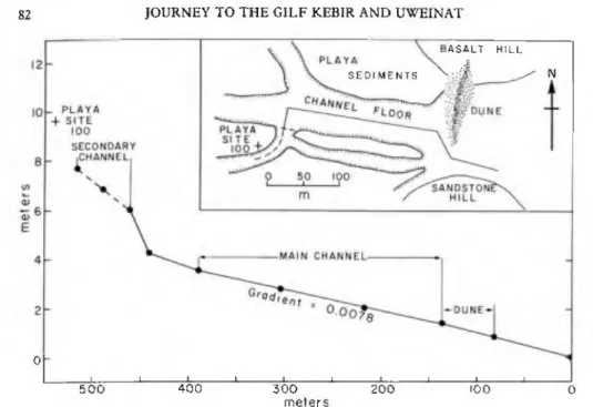
Due to the limitations of time in the field and petrol (rations of 100 km/day), only two wadis were investigated. This lack of adaptation is consistent with localized rainfall and runoff originating in the upper part of the wadi. Near the cliff, the bed in the playa deposits dips at low angles to the west (upstream), suggesting that dune growth (and resulting impoundment) kept pace with the dune growth at least during the latest episodes of piaya formation. formation of the intermittent lake.
However, the narrow part of the wadi is flat-floored and terminates in the 2 km amphitheater-like depression described by Peel (1939). Near the mouth of the amphitheater, secondary channels incised in the playa deposits are out of grade with the main channel (Fig. S). In contrast to the wadi interior, the wadi mouths at the southeastern end of Gilf Kebir have been heavily affected by aeolian activity.
The morphological similarity between the Gilf Kebir and the Colorado Plateau of the southwestern United States suggests that structural uplift of the Gilf Kebir may have occurred. Common on the aeolian peneplain lying between Kharga and Gilf Kebir are small, scattered, highly wind-eroded outcrops of the Nubian Series. The size and shape of the rocks were almost identical to those in the Viking scenes.
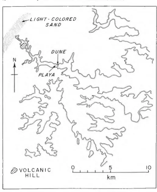
Siliceous concretions (called melons by British geologists) are common erosional debris on the wind-swept surface of 'kharafish' terrain. In contrast to the permanent and slow entrainment of coarser particles, fine to medium sand is easily salted in the fast winds everywhere in the Western Desert. In the Black Hill area east of Gilf Kebir (Fig, 2), surrounded by gravel plains, we observed longitudinal dunes growing southward into the shelter of the hills.
WIND STREAKS IN THE UWEINAT REGION AND MARS FAROUK EL-BAZ AND TED A. MAXWELL
The digging of this dune was made possible by the kind cooperation of the Egyptian Iron and Steel Company, in particular engineer Sayed Abdel Razik of the El Gedida iron mine. We thank the Geological Survey of Egypt for providing the vehicles for transportation between Cairo and Bahariya. References . 1970-71 Structures of Barchan Dunes in the Kharga Oases Depression, Western Desert, Egypt (and a comparison with structures of two aeolian microforms from Saudi Arabia). Because of their large size, the strip's dark pebbles are less likely to move under the sand-moving wind.
Consequently, the shape of the streak will change mainly in response to the shifting of the light colored sand on both sides. A similar environment was encountered by the senior author in the vicinity of Ras el Abd in Sudan (see Section I). Field investigation of dark streaks in the Uweinat area by the senior author suggests that the surface is also dotted with irregular discs of dark rock.
Usually the dark colored chips cover smaller, lighter red fragments and sand grains (Plate XXIVb). However, the color of the larger fragments dominates, giving the area a dark color in the field and in photographs of the Earth's orbit. These findings can help us better understand both bright and dark streaks on the surface of Mars.
FUTURE WORK IN THE SOUTHERN PART OF THE WESTERN DESERT
The iron ore we sampled on our expedition about 150 km west of Bir Tarfawi was very promising; as analyzed in the laboratories of the Geological Survey of Egypt, the concentration of iron in the red type is 25 percent and in the black ore is 58 percent. This ore could be economic when the new railway from Dakhla to the Nile Valley is built to transport the Abu Tartur phosphate ore. The phosphate layer of Dakhla extends along the southwest-trending scarps far beyond Abu Bailas (Fig. 9), Although the known layer is thin, measuring less than 60 cm, thick layers may occur.
Also, kaolinized material is exposed along the base of the cliffs on the western side of the Gilf Kebir Plateau. More importantly, the lithology setting is suitable for the concentrations of radioactive elements in the Uweinat area; the conglomerate horizon above the Uweinat granite may have the highest concentrations. Trade between Egypt and Sudan and between these two countries and Libya would be served by paving the desert roads (Fig, 9), perhaps the best way to fully study the area would be to assemble a multidisciplinary group from the three nations.
It is proposed here to first study the Egyptian part through the establishment of the three desert camps, shown in Figure 9. The exploration of the southern part of the Western Desert of Egypt is hampered by the lack of adequate maps. To serve as basic maps, it would be highly desirable to have orthophoto maps with contours on a scale of 1:50,000.
In the absence of map-quality photographs, mosaics must be created from digitally enhanced and color-corrected LANDSAT images.