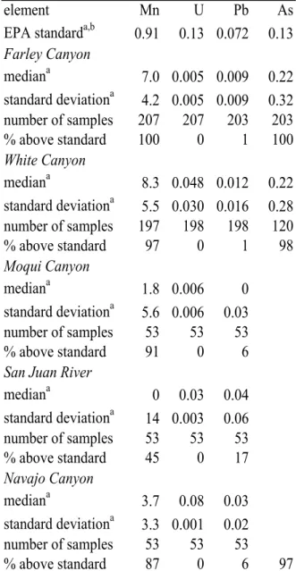
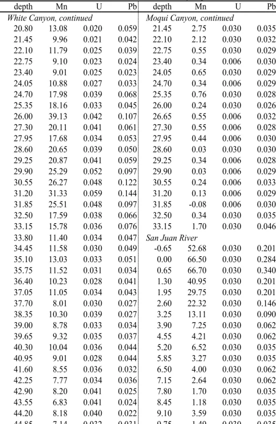
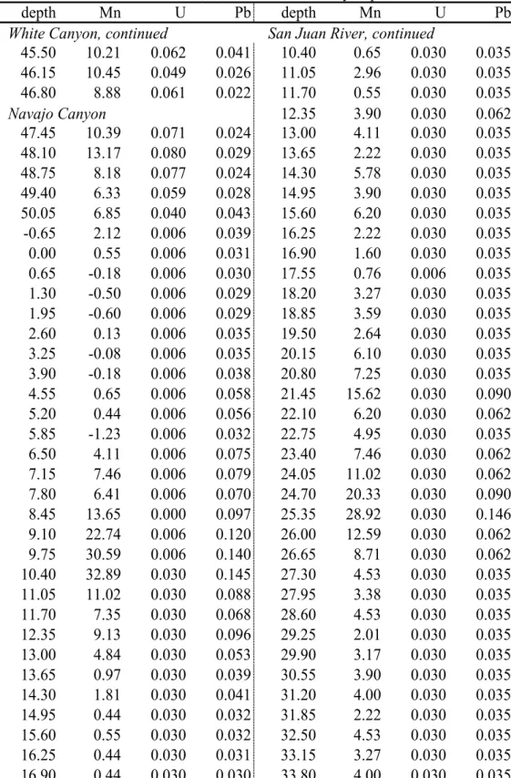
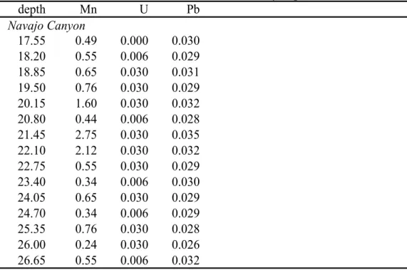
Kirk Johnson and Dean Murray wrote a 2004 article in The New York Times that first ignited my interest in studying Lake Powell. On the shores of Lake Powell, depth profiles of manganese and uranium were used to estimate the redox state of sediment pore water. In the Colorado River inflow region of Lake Powell, sediment samples were collected from the lake bed and shoreline.
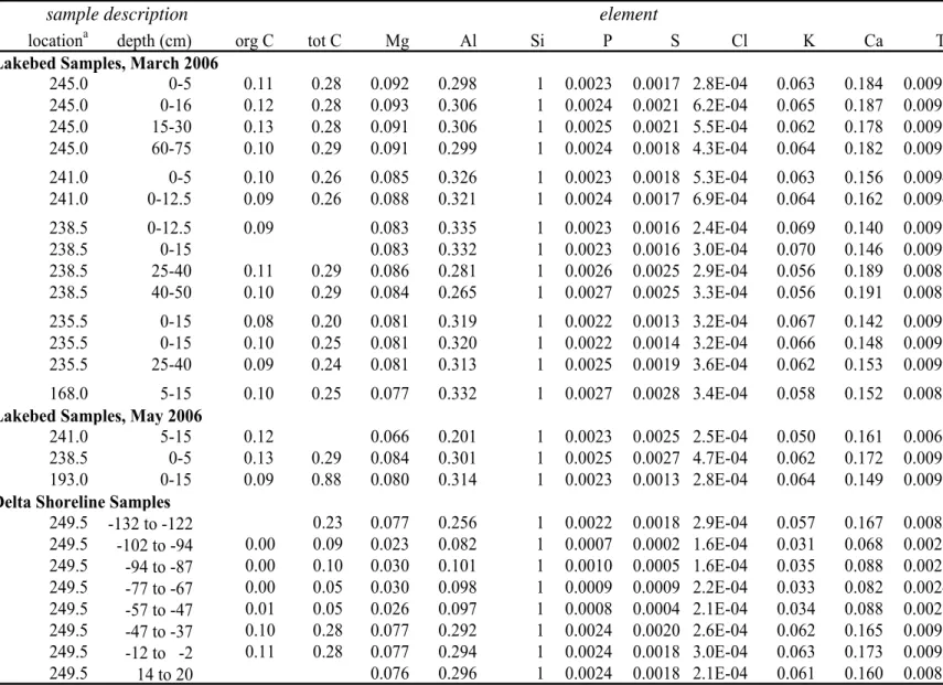
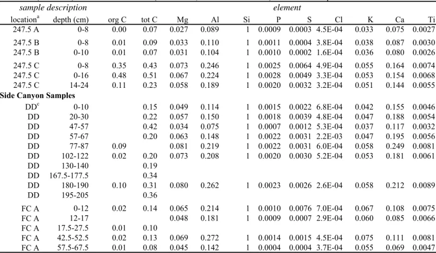
Groundwater samples collected from beneath the Merced River were analyzed for a variety of trace elements. 4 - 113 Figure S5 Total and organic carbon in Lake Powell Sediment 4 - 114 Figure S6 Concentrations of non-clay and clay minerals in Lake Powell.
Motivation
Either way, western irrigation adds water to the soil surface during dry seasons, inducing groundwater infiltration and runoff to rivers when their flow would otherwise be low. Diagenesis affects the chemistry of sediment pore water, which can diffuse into surface water, sometimes leading to the release of phosphorus (Gächter and Müller 2003), methane or mercury (Friedl and Wüest 2002) into the water column. Release of water from the middle of the water column in a reservoir may be lower in dissolved oxygen (Friedl and Wüest 2002), higher in methane (Guérin et al. 2006), or colder (Vernieu et al. 2005) than the pre-dam river.
Both dam releases and altered surface runoff can alter river flow characteristics, which can affect organic matter transport, algal growth, and nutrient transport and retention (Doyle et al. 2005). However, the extent of groundwater–surface water exchange was not quantitatively related to the resulting biogeochemical processes in the river with altered groundwater flow.
Research Topics and Brief Overview of Chapters
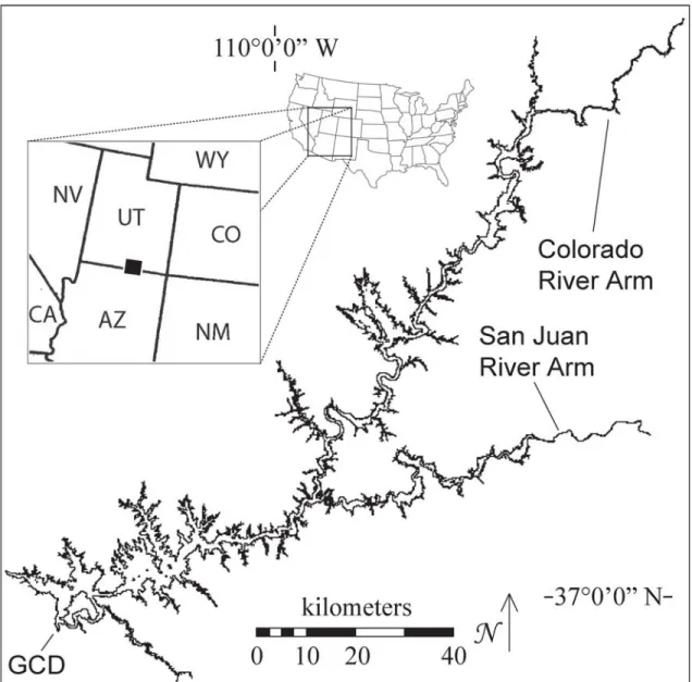
The long, narrow shape of Lake Powell and the high sediment load of the Colorado River allowed for an interesting study of the deposition patterns of inorganic chemicals in the reservoir. I designed the study, led some field expeditions and participated in others, measured all samples for particle size and elemental composition, processed and analyzed data, and wrote the manuscript. Pratson has helped me understand sedimentation processes in Lake Powell and will contribute side-scan sonar figures to the manuscript's appendices.
Since 2000, Lake Powell has been depleted due to a combination of severe drought in the headwaters of the Colorado River and the obligation to release water to downstream users. The likelihood that this new source of P supports an increase in primary productivity is discussed based on the results of this study.
In this study, I collected most of the samples, analyzed all samples for trace amounts of solutes, statistically analyzed the data, and wrote the manuscript. Hering secured funding for the project, assisted with data interpretation, and made many important improvements to the manuscript. In Colorado River Ecology and Dam Management: Proceedings of a Symposium May Santa Fe, New Mexico.
Glen Canyon Environmental Studies Review Committee, Water Science and Technology Board, National Research Council: Washington, D.C., 1991. In State of the Colorado River Grand Canyon Ecosystem (S. P. Gloss, J. E. Lovich, and T. S. Melis, eds.).
Hydrology and Water Quality of the Colorado River
First, the highest flow in the last 500 years occurred in the initial three decades of this time series (Woodhouse et al. 2006). Second, consumptive water use in the Upper Basin has steadily increased since the mid-1900s (Webb et al. 2004). Third, climate change appears to be shifting dry subtropical climate patterns to higher latitudes, leading to drier conditions on the Colorado Plateau (Seager et al. 2007).
Mining in the Rockies contributes trace metals such as copper, lead, zinc, and cadmium (Spahr et al. 2000) and these elements. Colorado Plateau and transported to the river by agricultural return flows, require special attention (Engberg 1999, Naftz et al. 2005).
Hydrology and Water Quality of Lake Powell
In the Colorado River headwater region, sandy sediment eroded from the uppermost delta region (upper part) was deposited in the region of maximum slope (forset), and, in the San Juan River arm, the upper and prograde sediment was transported down. reservoir at Glen Canyon Dam (Pratson et al. 2008). The denser river water enters the reservoir as a flow density current and either hugs the bottom for the entire length of the reservoir or. In late fall and early winter (November–December), convective circulation overturns the water column to a depth of ∼60 m (Gloss et al. 1980) and the cooler river enters the reservoir as a crosscurrent (Johnson and Merritt 1979).
Calcite precipitation is an important summer process that is more likely to occur in the lower region of the reservoir due to inhibition by organic compounds that are present in the inlet region (Reynolds 1978). The circulation patterns described above are very important to the dynamics of P, the limiting nutrient in the reservoir.
Early Diagenesis and its Implications for Inorganic Contaminants
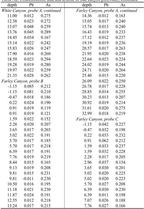
In addition, reservoir processes that are not fully understood can lead to seasonal plumes of anoxic water in Lake Powell (Vernieu et al. 2005), and under certain hydrologic conditions these can pass through the dam and affect water quality in the Colorado River (Vernieu et al. al. 2005). Willems 2007). Furthermore, environmental conditions can change the relative availability or energetic yield of different electron acceptors, and thus the reduction sequence described here cannot always be clearly observed due to the overlap in the use of electron acceptors (McGuire et al. 2002). Thus, the absence of oxygen and NO3- in the pore water of the sediment leads to the reductive dissolution of Mn and Fe (Froelich et al. 1979, Kneebone et al. 2002).
Reductive dissolution of these minerals can thus also release trace elements into sediment pore water (Kneebone et al. 2002, Campbell et al. 2008). Furthermore, some trace elements, such as arsenic and uranium, are redox active and thus will respond to the redox state of sediment pore water determined by the major redox species in a system (Campbell et al. 2006, Finneran et al. 2002).
Reservoir Sedimentation and Transport of Sediment-Bound Elements
In a narrow lake, such as a reservoir that has filled a narrow valley, the shape of the sediment delta can lead to a clear gradient in the particle size of the sediment. Large deltas will be strongly affected over time by changes in reservoir levels, with a drop in water level allowing the river to mobilize coarse sediment from the upper part of the delta further into the reservoir, and subsequent increases in water level causing fine sediment to be deposited on top. coarse sediment (Snyder et al. 2006). Vertical variations in sediment particle size will therefore be closely linked to the management history of a reservoir.
Reservoirs have been observed to retain both inorganic pollutants, especially when downstream from mines (Castelle et al. 2007, Lee et al. 2008), and nutrients (Teodoru and Wehrli 2005) in their sediment. Both the rapid sedimentation of organic matter and the subsidence of biomass from the banks lead to greenhouse gas emissions (i.e. nitrous oxide and methane) from reservoirs that are much higher than those from lakes or undammed rivers (Guérin et al. Kemenes et al. 2007).
Phosphorus in Lakes
P can reach bottom waters by transport by density currents below the watercourse (Gloss et al. 1980), diffusion from the sediment pore (Gächter and Müller 2003), or the breakdown of sinking organic matter in particulate form (Kalff 2002). In this case, convective overturning of the water column is an important step leading to primary productivity in surface waters, and the depth of overturning determines the extent to which hypolimnetic P reaches the surface water (e.g., Baldwin et al. 2008, Kalff 2002). The importance of overturning events is greater in reservoirs that release water from the middle or bottom of the water column, as.
If these reach an oxic region of the water column, Fe will precipitate and scavenge P. Internal loading of a water body in this way can maintain high concentrations of dissolved P even if external loading decreases (Ahlgren et et al. 2006).
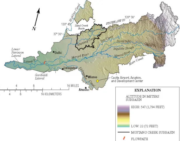
Water Resources and Water Use in the Lower Merced River Basin, California The Central Valley of California is a large, northwest-trending structural trough
Water Resources and Water Use in the Lower Merced River Basin, California The Central Valley of California is a large, northwest-trending structural trough. The location of the field site described in Chapter 6 is approximately where the Merced River intersects the flow path marked on the map. More than half (55%) of the Lower Merced River Basin is used for agriculture, mostly almond orchards, with some corn and cereal fields and vineyards (Capel et al. 2008).
Irrigation seasonally raises the water table, promoting a gradual flow to the Merced River (Phillips et al. 2007). In addition to irrigation water, 1 million kg of pesticides, 7.3 million kg of nitrogen, and 1.3 million kg of phosphorus were applied to crops in 2003 in the Lower Merced River basin (Capel et al. 2008).
Subsurface Hydrologic and Biogeochemical Processes in Rivers and Streams Exchange between stream water and groundwater can affect surface water
A coarse "armor" layer on top of finer sediment has been observed to have no effect on advection of water into the river bed (Marion et al. 2008), yet. The extent of infiltration is a master variable controlling the residence time of water in a river reach, which in turn is often the best explanation for observed differences in biogeochemical activity (Findlay 1995, Valett et al. 1996). Interaction between solutes in the hyporheic zone depends on both the contact time of the floodwater with the riverbed matrix and the type of solute.
Due to infiltration by stream water, the hyporheic zone is generally oxic, although pockets of reducing zones may exist where the sediment is less permeable (Salehin et al. 2004). Contact with sediment surfaces can also promote redox reactions: loads of dissolved Mn in a contaminated stream have been observed to decrease due to subsurface oxidation (Harvey and Fuller 1998).
Effects of drying and reflooding on sediment and soil nutrient dynamics of lowland fluvial floodplain systems: a synthesis. 2008) Human-induced changes in the hydrology of the western United States. Reston, Virginia: United States Geological Survey, 2005. Fluctuations, Drought, and Streamflow in the Colorado River Basin. After removing the sampler from the sediment, gels were removed from the sampler, transferred to the laboratory in polypropylene microcentrifuge tubes, and reequilibrated in 1% nitric acid (Campbell et al. 2008a).
Under oxidizing conditions, carbonate generally complexes UO22+ in the dissolved phase; upon reduction, solid uraninite (UO2) is precipitated (Wu et al. 2007). Two-dimensional and fine structure in iron and manganese concentrations in sedimentary pore waters. The crescent formed by the dashed lines shows the estimated extent of sediment removal from the levee at the side.
We observe a spatial trend in particle size in the Lake Powell delta sediment, but no statistically significant trend along the shoreline. The rate of sediment accumulation in the middle of the lake is much lower than in the delta. Thus, the type of rock surrounding a side canyon can predict the size of the sediment particles in it.
Of the clay minerals in the soil samples, illites dominate, followed by muscovite, smectites and kaolinite. 40 cm thick gravity currents can also move sediment along the reservoir bottom, especially in the delta region (Pratson et al. 2008). Thus, the significant chemical loads associated with suspended sediment in the Colorado and San Juan Rivers (Horowitz et al. 2001) are deposited in the lower reaches of their rivers.
Conversely, the upper areas of the deltas (and side canyons) are relatively lower in trace elements. The varying concentrations of carbon in the Colorado River Delta in Lake Powell could lead to a study of carbon decay in deltaic environments. Lake Powell is contained within the Glen Canyon National Recreation Area and surrounded by remote wilderness, so there is extremely little human presence in the side canyon that drains away from the lake.
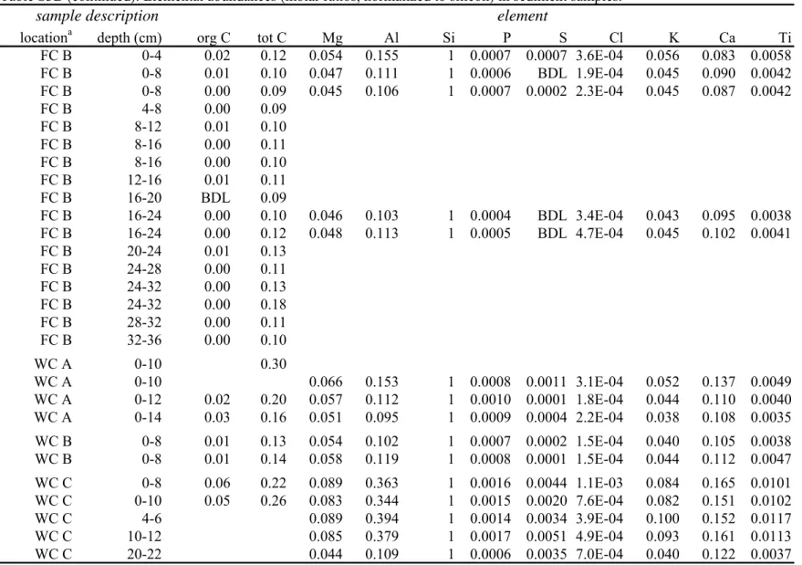
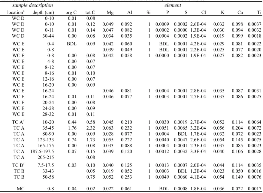
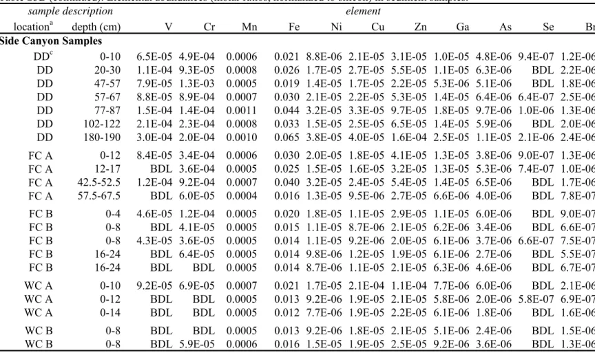
Deviation of the sum of mineral concentrations from 100% indicates a measurement error.