THE SÜNDARBANS WILDLIFE MANAGEMENT PLAN:
CONSE&VATIOK IN THE BANGLADESH COASTAL ZONE
A World Wildlife Fund Report supported by the World Wildlife Fund, Gland, Switzerland (lUCN/WWF Project No. 1011: 'Operation Tiger',
Bangladesh - Sundarbans Forest Division), and
National Zoological Park, Smithsonian Institution
International Union
for Conservation of Nature and Natural Resources Gland, Switzerland
1983
THE SUNDAEBANS WILDLIFE MANAGEMENT PLAN
conservation in the Bangladesh coastal zone
From: Government of the People's Republic of Batsgladesh, Forest Department, Dhaka
and
World Wildlife Fund, 1196 Gland, Switzerland
Prepared by: John Seidenstlcker, Ph.D.
Md. Abdul Hal, B.Sc.F.
The Authors: Dr. Seldensticker is a Wildlife Ëcologlst, National Zoological Park, Smithsonian Institution, Washington, D.C, 20008 (U.S.A.). Mr. Hal is in the Bangladesh Forest Department. He has been Wildlife Superintendent and has many years experience working in the
Sundarbans.
These proposals express the views of the consultants, which are not necessarily those of
International Union for Conservation of Nature and Natural Resources or World Wildlife Fund.
Frontispiece: Wildlife and man in the Sundarbans - Otters (Lutra perspiclllata) are used by some fishermen to drive fish schools into their nets (Seldensticker: March, 1980),
Cover by: Judy Gradwohl ICBN; Z-88032-802-0
(g) 1983 International Union for Conservation of Nature and Natural Resources World Wildlife Fund
COKTBNTS
SYNOPSIS 9 SCHEDULING OPERATIONS 10 INTRODUCTION 14 ACKNOWLEDGMENTS 16 THE SUNDARBAHS ECOSYSTEM 18 The Setting 18 Physiographic Expression 18 Land and Water 22 Tides 26 Aquifers 30 Climatic System 30 Storms 33 Matigroves and Estuaries 35 Wildlife Ecology 44 An Area of Environmental Concern 47 MANAGING TIGERS 62
Toward a Strategy for Tiger Conservation:
Components 62 The Objectives 62 The Information Base 62 Deriving Management Principles 63 Developing a Basis for Integrated Management 56 Problem Tigers - 66 Key Species, Key Processes 67
MANAGEMENT, MAN, AND THE SüNDARBANS 69 Goods and Services 69 Ecosystem Integrity and Management 69 Human Needs, Sundarbans Values 71 The Forest Management System 75 Structuring the Management Response 77 About Coaservation 80 STRATEGY, OBJECTIVES, TIME TABLE 81 Strategy 81 The Goal and Objectives o£ Management 82 Period of the Plan 82 MANAGEMENT PRESCRIPTIONS 83 Authority 83 Wildlife Sanctuaries 84 Organization 85 Programme Functions 85 Policy Committee 85 Programme Management 86 Operations; The Staff and Their Duties 88 Staff Development and Training 90 Skills Required 90 Methods 90 Long-Term Considerations 91
97 97 97 98 98 Law Enforcement
The Problem
The Law Enforcement System Tourism
Problem Animals
Summary nq
Research IQQ
Basic Studies j^Ol Detailed Studies 3^03
Coordination -J^Q^J
Visitor Use -.Qg Programme Guidelines j^OS A Tourism Development Scenario 105
Public Information 2Q7
The Audience lOy
Themes -¡Q-.
Design Materials, Methods 208
The Staff ^QQ
Facilities and Equipment HQ
Transport IIQ
Communications Facilities GLOSSARY
LITERATURE CITED
110 111 112 113
FIGURES
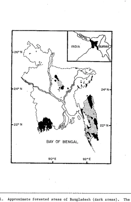
1 Approximate forested areas of Bangladesh (dark
areas). 19 2 LADÎDSAT image of the Ganges Delta. 21 3 The Sundarbans Forest Division: a) LANDSAT image
of the Sundarbans Forest Division.
b) Place names. 23 4 Sand banks and leesdows In the Sundarbans:
a) The Sundarbans East Sanctuary, b) Some sand banks are used seasonally as bases for fishing in the Bay of Bengal and at the mouths of the
big tidal rivers. 27 5 Sundarbans Forest quality classes and the land
development units in the Southern Region of
Bangladesh, 31 6 Cyclonic storm tracts in the Bay of Bengal,
1960-1970. 34 7 Vegetated tidelands of the Sundarbans:
a) An extensive forest tract showing the complex vegetatlonal mosaic, b) There is not the strong zonation in the Sundarbans mangrove communities that is apparent in many of the world's mangrove
forests. 37 8 The northern edge of the Sundarbans Forest Division. 68 9 People in the forest: a) "Country boats" are the
main mode of transportation and commerce in the Sundarbans. b) People waiting for permits to
collect firewood. 73
TABLES :
1 Monthly discharge of Ganges water before Farakka. 25 2 Characteristics of tides in the Sundarbans. 29 3 Average rainfall at Khulna. 32 4 Mean precipitation budget at Khulna. 32
5 Frequency of severe tropical storms In Bangladesh. 34 6 Sundarbans Forest Division site quality class areas. 36 7 Plant list for the Sundarbans. 49 8 Birds in the Sundarbans and adjacent areas. 51 9 Matomals in the Sundarbans and adjacent areas. 57 10 Reptiles and amphibians in the Sundarbans and
adjacent areas. 59 11 The endangered species of Bangladesh, 61 12 Staff organization, Sundarbans Wildlife
Management Programme. 86 13. Skills required by Programme staff. 93 14. Categories of specific skills required
by advanced level personnel. 94 15. Categories of specific skills required by
mid-level personnel. 95 16. Job qualifications for Programme staff. 96
SYHOFSIS
The survival in the wild of the powerful metaphysical symbol of Bangladesh, the Royal Bengal tiger, hinges upon the capability and the will of man.
The only remaining habitat of the tiger in Bangladesh's Bengal Basin is the 6,000 km^ coastal zone area, the Sundarbans Forest Division.
There is a chance for the tiger to survive on these harsh, storm-laehed tidelands. The area is large enough to harbor a viable population. But the tiger must be protected and its habitat needs must be met.
In the Sundarbans, tigers, deer, forest, and men are linked inseparably and so must be their management. Any attempt to separate the tiger from its prey, the deer from the forest, or people from their needs will surely fail. The tiger must be managed with all wildlife as an Integral part of forest management that assures the sustainable production of forest products and maintains this coastal zone at the level of best achievable ecosystem function to provide for the needs of the people of Bangladesh.
Developing the capability to manage the wildlife resource of the Sundarbans is a process. Protection is the first requirement. Habitat needs must be assessed on the basis of sound ecological data. The means of translating these into the forest management framework must evolve.
This plan outlines technical guidelines which assure the future survival needs of the Royal Bengal Tiger and all wildlife in the Sundarbans. But the capacity to realize this Plan and the successful husbandry of the wildlife in Bangladesh depends upon the professionals entrusted with the task, their skill and dedication. It depends upon the support they receive from the citizens of Bangladesh and people everywhere.
SCHEDULING QPERATIOMS
The summary following, for Management and the Policy Committee, sets out the orchestration of the broad elements of the Programme in accordance with the Plan.
Preliminary Action
- Appointment of the Policy Committee Government approval of the Plan
Financial projects prepared" and submitted
• Ap^proval of the proijeccs:
Year One
Government approval to commence executlûû o£ the Progrannaê
• Manager and Section Reads appoiratea - Sundarbans East Samttuary declared
~ Sundarbans wildlife protected by Gazette notification
- Staff selection and appointments completed
• Design of Khulna facilities instigated
• Ftfrchase of tteces,sary land completed- - Ord'érs p-laced- for launches
• All other equipment ordered and placed in service - Protection Stations designed and constructed
~ Organized paitrtuîiing comsiences
First group of staff goes for in-service cra-ining in- wildlife management
Man^eer goes abroad for three month training course Basic studies prcgramme implemented
Initial repo-Et prepared on vital areas
10
Public Relations Officer and staff work with Conservation Education Specialist; plan and basic materials prepared
Year Two
- Operations continue
- Construction of Khulna facilities
Wildlife Superintendent, Research Officer, and Publications Officer go abroad for three month training course
In-service training course continues •
Law Enforcement Specialist works with the Law Enforcement staff for two months
- All launches in service
Revised vital area report prepared
Tourism potential plan prepared; preliminary tourism operations started
Year Three
- Operations continue
- In-service training continues
Conservation Education Specialist assists Public Relations Officer in assessment and infusion of new materials and more sophisticated
techniques
- Tourism operation expanded Tiger ecology study at.âCts Year Four
~ Operations continue
- Mid-term appraisal
In-servics training continues - Tourism operations expand
Public relations work expands
Law Enforcement Specialist assists for two months
Year Five
- Operations continue
In-service training continues
" Tourism operations expand
Conaarv^tLou Education. Specialist assists Public Relations Officer in assessment and infusion of new materials
- Crocodile ecology project starts Year Six
- Operations continue
- Tourism operations continue
- Preparation of the second plan started - Public relations work continues Year Seven
- Operations continue
Second five-year plan completed
Final Report for the programme prepared Detailed Operation Plans
- 'Sundarbans Wildlife Management Programme: Requirements for Future Staff Training and Development' by Section Heads; year 1
- 'Sundarbans Law Enforcement Plan for Wildlife' by Wildlife
Superintendent; year 1 and revised in years 2 and 4 with assistance of the Law Enforcement Specialist
'Visitor Protocol' by Section Heads; year 1, revised as necessary 'Vital Habitat Areas Assessment' by Research Officeï'; year 1, revised each year
Proposals for Basic Studies by Research Officer, before implementation
Proposals for Detailed Studies by Visiting Scientists and Research Officer; before implementation in years 3 and 5
12
'Conservation Education Plan' by Public Relations Officer and Conservation Education Specialist; year 1, revised years 3 and 5
'Tourism Potential and Use Limitations In the Sundarbans Forest Division' by Section Heads; year 2
INTRODUCTION
Bangladesh is a land born of great rivers. The Ganges, the Brahmaputra, the Meghna join here and flow Into the Bay of Bengal, forming the largest delta in the world. The monsoon rains, the rise and fall of river levels, floods, alluvion and diluvion, alluvium, the changes in river courses form the substance of the cultural and physical
personality of this land.
On the delta and along the great rivers once lived a diverse assemblage of large mammals few areas in the world could equal (Elsenberg and Seidensticker, 1976). The forest and lush grasslands are mostly gone now, and so are the animals that depended upon them.^ Today
conditions are such that we can only hope to maintain a few small tracts with the vestige of a wildlife heritage that once was.
More than eighty million people live in Bangladesh today. Less than 151 of the nation remains under forest cover (Rashld, 1977). But in
Bangladesh, at the edge of the land that Is not quite sea, there remains one of the world's great wild places - the labyrinth of channels and beautiful forests of the Sundarbans. Here on these storm-lashed
tidelands the feared, respected, awesome, largest of all cats, the tiger (Panthera tigris tigris) has been pushed to the final edge of existence.
"The challenge of the tiger is at the heart of conservation", Dr. Fritz VoXlmar, long-time Director General of the World Wildlife Fund, once said (F. Vollmar, personal communication, 1977). This splendid predator is a symbol no less today than it seems to have always been for man.
The tiger is in trouble (Goodwin and Holloway, 1972). Man is
responsible for its plight. Only man can assure Its survival needs are met.
How often has man, in pursuit of short-term advantage, dissipated the natural capital oti which our long-term prosperity, our survival, is based? The purpose of conservation is to maintain this Earth in a healthy operating condition; it Is a process of evolving a harmony of human and natural systems, a man-land rapport.
Coastal zones are among the World's most Ill-treated ecosystems; usually they are a no man's land where every man takes what he can (Dasmann, 1973). Properly maintained, many coastal zone areas are the most productive on earth but they are particularly vulnerable to man-induced stresses (Clark, 1974). The Sundarbans Forest Division has been managed with care; the long-term sustained outturn of forest products speaks well for the professionals responsible. And the tiger has survived.
^Latin names of fauna and flora ate given in Tables 7-10.
14
If there Is one suture In the hundred year history of the management of the Sundarbans that has resulted in management success it has been a continuing effort to improve the management system In the face, of ever increasing demands. Had that not been true there would be no forest.
The continued survival of the tiger pivots on the well-being of its prey and the forest. Accordingly, the tiger will survive only in the sphere of wildlife management which is a part of-forest management that assures the sustained production of Nature's goods and services to provide for the needs of the people of Bangladesh. A simple linkage in theory; a complex task in practice. And it is not a one-way street.
This Plan Is part of a continuing effort to refine the management matrix to include all components of the Sundarbans ecosystem. It Is based on the principle that the best achievable function will provide the greatest benefit in terms of natural goods and services to society in
the long•run. It Is abundantly clear that the coastal zone Is an area of environmental concern and the management- of this zone will require all our ability and, perhaps, more. Indeed, the tiger Is symbolic in
this effort but it is central. The tiger will survive only if ecosystem function Is maintained. And only a management expertise that can preserve sensitive wildlife species has the problem in hand. The power to do so must develop over time.
We have prepared this report in two parts. First, we examine the Sundarbans ecosystem - what it Is, why it is, and where it is going. To do this we inventory the physical, biological, and management systems;
describe. In general terms, the natural and social processes; and identify the factors necessary for its perpetuation. The Plan.is founded on propositions derived from this analysis. Management objectives are articulated. A strategy and the prescriptions of a process for achieving these are outlined. A schedule of operations is included.
There is only one question really: Do we have the will and the capacity to meet the challenge?
ACKNOWLEDGEMEHTS
I have been fortunate to have spent a large share of my professional life investigating and analysing wildlife and related matters in the Ganges Basin. The patterns, the people, the pulse of this land have become a part of me and there is a nagging urge to keep coming back.
It was with great pleasure that I received the initial request in 1978 from the Forest Department through the World Wildlife Fund to come Co Bangladesh and look into the problem of wildlife conservation in the Sundarbans.
My task of assessing needs and preparing this plan has been aided in every possible way by my co-worker, Mr, M. A. Hal. Discussions with companions on our trip to the Sundarbans, Mr. F, Karlm, Secretary of Che Bangladesh Wildlife Preservation Society, and Mr. A. W, Akondai Senior Research Officer, provided much background, into conservation matters in Bangladesh. Mr. A. A. Bhuyan, Divisional Forest Officer, Sundarbans Forest Division, put his facilities at our disposal. He and Mr. R, A.
Choudhury, Conservator o£ Forests, shared their frank appraisals of needs, ways, and means for a Sundarbans wildlife management programme.
In Dhaka, we have had the full assistance and advice of Chief Conservator of Forests, Mr. A, Hamid, Mr. A. W, Khan, Deputy Chief Conservator, and Mr. A. H. Choudhury, Conservator of Forests
(Wildlife). Dr. M. 0. Ali, Director of the Forestry Research Institute, provided insights into training capability and needs. Dr. A. Hossain and Mr. M. Choudhury provided the LANDSAT photographs. Mr. G. M. M. E.
Karim shared his views on tourism. Mr. K. M. Salahuddin obtained important references for us. These men, the crew of the launch Bana Kannya, and all the Forest Department personnel who assisted made the preparation of the draft plan possible.
The National Geographic Society sponsored my return visit to Bangladesh in 1980. His Excellency, Ambassador Tabarak Husan, and Press and Education Counselor, Mr. M, Alam, made this possible. My colleagues.
Dr. C. McDougal and Mr. T. Kebbia, assisted in Dhaka and in the
Sundarbans. Dr. McDougal and I undertook distributional surveys of deer and tigers and he provided a strong input to the section on tourism development. Our work was facilitated by Wildlife Superintendent, Mr.
A. W. Hamid, Divisional Forest Officer, S. All Iman, and Additional Divisional Forest Officer, Mr. S. Choudhury, at Khulna. Mr. A. W, Khan and A. Hamid again provided full assistance and advice in Dhaka.
Captains Rdhman and Ameer of the Civil Aviation Department flew us over the forest; the crew of the launch Bana Rani transported us within.
Mr. Anton Fernhout (WWF) and Mr, J. McNeely (IÜCN) have directed and supported this project from the beginning. Dr. C. Holloway (IÜCN) and Dr. S. Snedaker {University of Miami) served as reviewers.
16
At the National Zoological Park, Smithsonian Institution, Washington, D.C. (U.S.A.) senior staff, Dr. T. Reed, Dr. J, Elsenberg, Dr. D.
Kleiman, and Dr. C. Wemmer have provided continual counsel and support for the JNatlonal Zoo's wildlife conservation prograimne. Br, M. Sunquist shared his extensive knowledge of tiger ecology and behavior with me.
Dr. S. Lumpkln edited the manuscript.
To all of you - Thank you.
John Seldenstlcker
THE SUNDARBANS ECOSYSTEM
Protection of species and natural communities is a logical first step In the development of a region. This is the premier ecological principle for economic development. Put another way: "The first rule of lateliigent tampering is to save all the pieces." Aldo Leopold reportedly wrote that. It was 50 years ago that he published the textbook on wildlife management (Leopold, 1933), but his fundamental teaching, you can't keep the pieces unless you look after the whole, has never been more to the point. Let us start with the whole and with ".,, the basic proposition that nature is process, that It is interacting, that it responds to laws, representing values and opportunities for human use with certain limitation and even prohibitions to certain of
these" (McHarg, 1969, p. 7). It is only within this framework of thought and management that the Royal Bengal Tiger, wildlife, or even the Sundarbans will survive.
The Setting
The Bangladesh Sundarbans is the juncture and focal point of two vast ecosystems. Melting snows in the Himalayas and the Tibetan Plateau and the runoff of monsoon rains collect in rivulets and streams and rivers that flow down to the plain and sea bringing the nutrients, the soil, the life source to the Bengal Basin, the Bay of Bengal, and the Indian Ocean. Three great rivers, the Ganges, Brahmaputra, Meghna, fed by so many others which are small only in comparison, converge in the Bengal Basin and over a span of time not really comprehensible by man have formed an 80,000 km^ delta (Leong, 1971). Fringing the delta Is a
'sea forest', perhaps the largest tract of mangroves In the world (BWDB, 1977), incised by great estuaries and labyrinthine channels. This 6,000 km^ area constitutes the Sundarbans Forest Division (Fig. 1).
Physiographic Expression
Several physiographical and geological considerations are pertinent to understanding the Sundarbans ecosystem and its place in the development of the Bengal Basin. It is such an active tectonic region that one has to begin by considering the superficial expression of these crustal movements.
In the Eocene Period, some 50 million years ago, the Subcontinent collided with and subducted under the main Asian mass (Rashid, 1977), This process continued and the Himalayas are one manifestation. A number of million years later, in the Oligocène, a sizable chunk of the Subcontinent fractured and sank, filling, in time, with sediments washed down from the adjacent mountains and plateaus. The volume involved is
18
Figure 1. Approximate forested areas of Bangladesh (dark areas). The stippled areas are scattered forest and scrub. The Chictagong Hill tracts are on the west and the Sundarbans Forest Division is south on the Bay of Bengal (after Rashid, 1977).
Incredible. The sediments of just the last few million years are as much as 1000 m thick. Bounded by the Himalayas to the north, the Rajmahal Hills on the west, and the Meghalay Plateau and the Chlttagong Hills on the east, we know this region today as the Bengal Basin.
The surface of the Basin is carved and moulded by the rivers expressing the underlying geological structure. On the delta, the active and recent channels are wide. Incised cuts; a multitude of older channels have eroded into broad, flattened depressions, many containing bils and swamps. Those older channels that connect directly with the Bay are scoured by the tides. In their lower reaches they are relatively straight and wide and those with little or no connection with the main channels have become tidal rivers (Choudhury, 1968).
The main Ganges and/or Brahmaputra distributaries have shifted frequently in the last few hundred years. In the seventeenth century most Ganges water entered the Bay through the Hoohgly-Bhagirathl
channels near Calcutta, But later it shifted progressively east. Man's activities in the upper watersheds vastly increased silt loads and this coupled with a fluctuating climatic regime resulted in channels closing and new ones opening. But this change also is an expression of changes in the Basin's support structure. The Basin has tilted and regions have subsided through tectonic activity or the weight of overlying deposits or both. The general tilt is away from the'old Ganges channels in the southwest to the major subsiding trough along the present drainage axis. And within the Basin there are other areas that have been or are subsiding (BWDB, 1977).
Looking at the LANDSAT image of the delta (Fig, 2), the physiographic distinctness of the large region south of the mala river channel, the darker area, is clear. This is the Sundarbans. Core sampling has shown that this region may have subsided as much as 10 m in the recent past.
Exactly when this happened is not certain but the large ruins, such as the 600 year old temple at Shekertek, in the swampy area may be an indication. Today this region is lower than the adjacent areas and very much influenced by the tides. The tides and the limited flow of fresh
•water through the area combine to keep this portion of the delta in a rather immature state.
Figure 2 (next page). LANDSAT image of the Ganges Delta. The Ganges or Padma joins the Heghna at top right. Dhaka Is just out of the image above the main Ganges near the Meghna. The Sundarbans is the darker expanse on both sides of the international boundary on the Bay {Jan., 1977).
20
Land and Water
Only the Baleswar River {Fig. 3) has a sustained freshwater flow via direct connections with the Ganges, or at least it had before Farakka.
The other big rivers, the Passar, Sipsah, Arpangasis, Malaachar and to a lesser extent the Jamuna and Raimaagal, are only indirectly connected if at all; the only fresh water they receive is local runoff and the overflow from the Ganges during the motisoott. Conttectloas with the Brahmaputra are minimal and with the Meghna, not at all (Choudhury, 1968). But the Ganges connection means the Bangladesh Sundarbans is literally on the receiving end of the sum total of happenings in that 910,000 km^ watershed. An indication of the pulse of this system can be seen by looking at the average monthly discharge, before Farakka, of Ganges water and the offtake of the Goral, the upper Baleswar (Table 1). The Gorai offtake that supplies the freshwater to the Sundarbans tracks the Ganges discharge both in volume, to a threshold, and on a percentage basis; but the less water, the smaller the percentage that flows down this distributary; 11,000 million m^ appears to be about the maximal limit the Goral can handle. Flows in this range coupled with local rains during the monsoon aggravate flooding conditions which lead to â general "freshwater flush" of the Sundarbans system.
The alluvial soil of the delta is acid sulphate. The surface is usually a silty clay•overlying layers of clay and sand. The rivers with direct connections with the Ganges, In the east, carry more silt, and during the monsoon, silt is spread over nearly all the land area. Clark (1974, p. 3) has noted; "The highest concentrations of sediments carried by estuarlne waters are found in the Inner, low-salinity, portion. Here salt water meets fresh, coalescing river-borne silts into larger, heavier particles which settle out as the estuary broadens and flow
slackens." In the western areas where the rivers do not have this regular fresh water connection, silting is much reduced.
The land is moulded and shaped by the action of the tides. Innumerable small khals (creeks) drain off the land area with each ebb. The banks of the rivers and khals generally become higher as silt is deposited with the flood tide when the water loses its speed and starts slowly to spread. Then more khals form to drain the higher areas and the process is repeated on a gradually diminishing scale until the small creeks draining the bil areas in the middle of the islands are formed. More easily eroded than the clays and silts, sands are deposited in and dragged down the channels. Silts, deposited on the top of the islands during each flood, consist of the fine particles which produce the heavy clay soil so typical oí the delta (Choudhury, 1968),
The small drainage channels, the khals, characteristically form at right angles with the main channels. Some join (bharani khals) providing links between tidal rivers that pierce the delta. The tidal rivers tend to be long and straight as a result of the strong tidal scour and the erosion-resistant clay and silt deposits that form their channels.
22
RANGE COMPARTMENT • SANCTUARY ftC^i FOREST STATION «
10 KM
90»E KHULNA
•N-
\MANOÔRBARIA^JS., J-""
BAY OF BENGAL
Figure 3. The Sundarbans Forest Division: a) Place names. Stippled areas are designated sanctuaries, b) LANDSAT image of the Sundarbans Forest Division (Jan., 1977),
24
Table 1
Monthly discharge of Ganges water before the construction of the Farakka Barage in India
(in millions of m^}
Hi scharge of Ganges
at Harding Bridge Offtake by Gorai
t
January 8,338 913 11
February 6,562 617 9
March 6,192 530 9
April 5,329 370 7
May 5.279 530 10
June 11,175 1,406 13
July 47,872 7,178 15
August 100,579 10,509 10
September 89,675 10,904 12
October 46,194 6.,.8.2i 15.-
November 18,441 2,442 13
December 11•237 1^295 12
Total 356,873 43,515
Total Discharge Brahmap jtra 618,311 Total Discharge Meghna 113,777
Source: Bangladesh Water Development Board (1977).
rivers tend to be long and straight as á result of the strong tidal scour and the erosion^resistant clay and silt deposits that form their channels. It Is this morphogenetic process that gives the Sundarbans its characteristic pattern of water and land (Fig. 3).
The easily eroded sands eventually collect at the mouths of the rivers.
The banks and chars that develop on the sea face usually consist only of sand particles; any finer silts are washed out with the waves and gradually settle onto the shelf further out in the Bay. The sand banks are blown into dunes above the high tides during the strong southwest monsoon. In the lee of the dunes, protected from the wavesj fine silt collects, and thus, mud flats form. Sand from the dianes is blown over the flats and in this way a flat stretch of sandy loam is formed above the high tide level. This develops into a grassy midden which spreads until arrested by a khal or early forest growth (usually Gewa,
Excoecaria sp.). The midden continues to build as long as the area on the windward side of the island is unprotected from the waves (Fig. ^). • With the formation of the next island further out, the shore of the island begins to collect silt and the sand is blown or scoured away.
Traces of dunes and remnants of sandy middens can occasionally be found some distance inside the forest. Such middens form on the southeastern coasts, unprotected from the south west monsoon. Wind and waves erode the exposed eastern coasts.
Tides
Tides in the Sundarbans are of the semi-diurnal type with a small diurnal irregularity (Choudhury, 1968; EWDB, 1977). Characteristics are summarized in Table 2. The influence of the tide depends upon the stream flow and that depends on the time of year and the connection the river has with the fresh water supply. In the eastern Sundarbans it would be less; in the West, much more marked. The speed of the tidal wave will vary from 50 km/hr at the sea face to 25 km/hr in the upper reaches. Tidal currents usually vary from 35 km/hr at the sea face to 7 km/hr in the upper reaches of the forest, even 10 km/hr during an ebb in the rainy season. This increase in speed is caused by the gradual constriction of the rivers in the upper reaches (BWDB, 1977). Moreover, the tidal current in the large rivers continues to run on its own . momentum for an hour or so after the tidal wave has passed. Thus, at the end of the ebb, the suction of the current deepens the trough of the tidal wave and by retarding the progress of the oncoming wave, causes it to back up and heighten its crest. Consequently, the largest rise and fall of the tides are found where the tidal currents are swiftest and this is usually in the northern part of the.forest.
A primary driving force that moves saline ocean water up an estuary is the difference of its density with that of fresh water, i.e., 1028 kg/m3 vs 1000 kg/m-' with a difference of 28 kg between the two water mases TBWDB, 1977), This alone will cause a salt water wedge to move upstream, A minimum flow of fresh water is required if the wedge is to be retarded. Fresh and intruding sea water will mix finally and tides facilitate this. The emerging pattern of all this is that estuarine
26
M!'
Table Z
Characteristics of tides in the Siindarbans
Mean Range Mean Spring Mean Tide (m) Range Level
Eastern Delta
Kwtutdia Island 2.7 3.4 2.0 Mouth of Passur River 1,7 2.4 2.0 Mouth of Hooghley River,
West Delta 3.0 4.3 3.0
The time of the high tide at Kutubdia Island and the Pussur River (Hiran Point) lags behind that at the mouth of the Hoohgley by 1 hr. 45 min., i.e., the tidal wave goes from west to east.
Source: Bangladesh Water Development Board (1977),
Figure 4 (pp. 27 and 28). Sand banks and meadows in the Sundarbans:
a) The Sundarbatis East Sanctuary (Seidenstickex: March, 19S0).
b) Some sand banks are used seasonally as bases for fishing In the Bay of Bengal and at the mouths of the big tidal rivers (Seidenstlcker: March, 1980).
estuarine circulation is controlled by the tidal flow and fresh water discharge. How these interact will determine the salinity zones, sedimentation patterns and the distritiution of minerals, nutrients and organic matter. A natural rhythm and patterns of flow and Interaction are established in time. Any sudden change results in a shock to the organisms adapted to the system.
Aquifers
The available information (BWDE, 1977) indicates the entire Southern Region (Fig. 3) is underlain by a single aquifer composed of lenticular granular materials. Intercalated clay beds resist flow horizontally or vertically in some localities. The relatively Impermeable surface deposits of silty clay confine the aquifer where they occur. Maximal depths to water are in the southern reaches of the delta. Locally, permeable lenses of sands are separated from the principal aquifer by impermeable deposits resulting in perched shallow aquifers. Fishermen dig shallow pits on the sea face to obtain 'sweet' water. And there appear to be a limited number of places within the swamp where water can be reached with shallov wells (Hendrichs, 1975). Fresh water
availability in the Sundarbans, however, is very much a limiting factor.
Climatic System
Ûf primary concern here in relation to vegetation structure and productivity is the variation, amount, and seasonality of rainfall and the frequency and intensity of storms. The global energy exchange system is expressed as monsoon winds which, from June to October, bring moisture-laden low temperature centers from the Bay of Bengal and the Indian Ocean. On average, 80% of the rain falls during this period which, from 1934 to 1969, averaged about 70 cm at Khulna. But averages, other than giving you a ballpark idea of the situation, don't really mean much. Consider the variation during the same period at Khulna
(Rashid, 1977; BWDB, 1977) shown in Table 3 and the situation is further complicated fay other factors. Mean July temperatures are lower in the Sundarbans than farther inland while in January they are slightly higher. Rainfall rates vary considerably in the Southern Region. On the sea face the mean average is about 279 cm annually; at Khulna the mean is slightly less than 18.0 cm.
During the rainy serson, humidity is high and the sky overcast for long periods; maximum temperatures may exceed 32°C. By November, the rains have subsided and it is relatively cool; low temperatures can be 2-4°C; skies are usually clear. By March the temperature can reach 43°C. Ag much as 15% of the yearly rain can fall in March, April, and May, before the monsoon, as part of frequent, short, violent thunder storms. The centers of these storms, known as 'nor-westers', originate in the adjacent hills and sometimes are accompanied by hall. This storray period merges with the monsoon season proper so there is no sudden onslaught or 'breaking' of the monsoon as in other parts of the Subcontinent, In January and February, small amounts of rainfall can result from.the western depression.
30
BAY OF BENGAL
Figure 5: Sundarbans Forest quality classes and the land development units in the Southern Region of Bangladesh (after EWDB, 1977),
Table 3
Average rainfall at Khulna between 1934 and 1969 (In cm).
Jan Feb Mar Apr May June July Aug Sept Oct Nov Dec
Mill -00 00 0,8 15,7 19,3 18.8 10,1 3.6 0 0 Max - 13.5 9.8 16.0 29.2 53.1 63.2 62,0 54,9 69,3 54,9 17.5 4.8
Source: Bangladesh Water Development Board (1977).
Table 4
The 1931 to 1960 mean precipitation budget for Khulna (in cm).
Jan Seb HaT Apr Hay June July Aug Sept Oct Nov Dec
Excess 3.6 17.0 24.1 15.7 8.4 1,5
Deficit 8.4 8.4 10.1 5.6 8,4 10.2
Source: Bangladesh Water Development Board (1977),
For the Sundarbans there Is a six month dry season during which
precipitation falls short of evapottatispitation. The 1931 to 1960 mean precipitation budget data for Khulna are summarized in Table 4. The three severe months are February, March, and April because of the depletion of soil moisture and increased concentrations of salts coupled with reduced freshwater flow from upstream.
Storms
Tlie impact of severe storms on the forest is profound. It is during these periods of high-energy influx that much geological work, is done and the storms guide the long-term development of mangroves and forests. The distribution of severe tropical storms for Bangladesh follows but there has been an increase in the frequency of storms (Table 5, Fig. 6).
Severe storms (cyclones) affect the waves, swell, storm tides, and current system in the Bay, and the volume and rate of fresh water discharge from the land; all the energy regimes may be affected for days or even weeks (Riggs, 1976). A cyclone can cause defoliation of
mangroves even at relatively low levels of intensity and complete structural destruction at high levels. The general result is the conversion of living structure into organic debris (Lugo and Snedaker, 197A). Mangroves recover; these communities are adapted to recover.
But we do see the composition and structure of conmiunities on those coasts with frequent storas differ considerably from protected coasts
(Lugo and Snedaker, 1974; Pool et al., 1977). The impact of cyclones on exposed inhabited delta lands on the sea face can be tragic. In the ten year period, 1960 to 1959, eleven major storms resulted in the reported loss of 54,000 human lives in Bangladesh. On November 12-13, 1970, a cyclonic storm coupled with a high tide resulted in the loss of more than 200,000 human lives (Anonymous, 1970). Some ad hoc measures taken to deal with cyclone hazards have increased flood-loss potential (Islam, 1974).
The combination of forces that causes cyclones has not been fully determined. Some storms appear, to be literally sucked up the estuaries, where the stable cool air over the. water heomied by the warm air rising from the land form a trough along the axis of the storm path which acts as a funnel. But this is not always true. Winds can reach 250 km/hr.
The storm wave may be up to 75 m in height (Rashid, 1977), Without the attenuating influence of the forest the loss of human life and property Is catastrophic.
There Is an awesome calu before a storm. The light changes and the water and forest backed by the mottled, steei-grey wall of clouds take on a vivid texture and contrast which intensifies as the storm closes.
Then, there is only unleased fury. After it is over, nothing is ever quite the same.
Table 5
Frequency of severe tropical storms in Bangladesh,
Jan"Mar Apr May June July Aug Sept Oct Kov Dec Total
1891-1960 0 2 300 0 2612 16 1961-1977 0060021532 19
Data courtesy of Bangladesh Meteorological Department, Storm Warning Center, Dhaka.
Figure 6. Cyclonic storm tracts in the Bay of Bengal, 1960-1970 (after Rashid, 1977).
34
Such are the physical processes of tbe Suntlarbans. The result Is a very dynamic ecosystem.
Mangroves and Estuaries
Mangrove communities iorm on the protected shores of the tropics and subtroplcs where they dominate roughly 25% of the coastline and reach their greatest richness In the Indo-Faclfic region (Chapman, 1975). The word mangrove (a combination of the Portguese mangue and the English grove) can refer to an ecological group of halophytic plants belonging
to twelve genera In eight families, or to a complex of plant communities fringing sheltered tropical shores, or more specifically by some
authors, to the vegetation formation below the high tide mark (Lugo and Snedaker, 1974). An early classification of Subcontinent forest types by Champion (1936) placed the Sundarbans forests in the moist tropical serai forest type (primary sere) which can further be divided into beach forest and tidal forest of which there are four subtypes: low maagrove forests, tree mangrove forests, salt-water Herltlera (Sundri) forests, and fresh water Herltlera forests. Foresters have devised a
classification based on site quality class, referring to the
productivity of the forest on these sites. On this basis,.the areas of forest in the Sundarbatis Forest Division are listed in Table 6 and shown in Fig. 5.
Honoring tradition we should consider the vegetation composition viewed as a species list and as zones. There are reported to be 33i plant species of 245 genera-in the Sundarbans. The principal woody and herbaceous plants found there are listed in Table 7 together with their Bengali names. Other investigators have seen mangrove communities in terms of zones reflecting frequency of inundation, or salinity of the soils, or even the generic name of the dominant tree (Lugo and Snedaker, 1974; Macnae, 1967, 1968). But with its relatively flat profile, the Sundarbans vegetation is best seen as a mosaic and the zone concept is only applicable on a very broad scale (Fig. 7).
There is, then, considerable diversity in the way the forest can be classified or what the terms employed can mean. Each in their own way, they are descriptive classifications dependent upon what kinds of distinctions the user was trying to make. The forester's 'quality class site' classification reflects productive potential of the forest land areas as a sum of all environmental factors that promote forest growth.
The Champion classification closely resembles a physlognoiüic classification based on structure within a larger classification of plant succession and environmental factors (Mueller-Dorabois and Ellenberg, 1974). The point is not to be confounded by classification systems; neither is there a need to go into these in more detail here.
The Sundarbans has been cover mapped on the basis of aerial photographs and these raaps are available in the Forest Department. The Bangladesh ERTS/LAfTOSAT Programme is now starting to remap the region and is including in their analysis a consideration of the environmental factors
Table 6
Sundarbans Forest Division site quality class areas.
Site Quality Class Total Area (ha) Percentage I 102,607 25 II -93,822 22 III 182,838 45 Immature forest 1,251 t Non-commercial forest 21,194 5 Char land 5,020 1 Clear land 198 t
Source: Bangladesh Water Development Board (1977) and Choudhury (1968).
Figure 7 (next pages). Vegetated tldelands of the Sundarbans;
a) An extensive forest tract showing the complex vegetational mosaic (Seldensticker; March, 1980).
b) There is not the strong sonation in the Sundarbans mangrove communities that is apparent in many of the world's mangrove forests. The boats support a forestry operation
(Seldensticker: March, 1980).
36
^t^lf mi%%:ir
-, ^r' .^
1Iff tî^
that lead to the different vegetation structures observed (H. Hossaln and M. Choudhury, personal communications, 1978 and 1980).
And this is the point. The descriptive systems reflect the variation in the environmental factors that govern the physiognomic expression of mangrove forests and vegetatioci in general. These factors as they
relate to mangroves are under Investigation in many parts of the world but the available findings suggest there are large variations- between species in survival strategies that are related to tidal amplitude and flux, water quality, storm frequency and Intensity, geomorphologlcal processes, soil salinity, temperature and others (Pool, et al., 1977).
Xn tine terminology of the ecologists who work with forest systems analysis, these are called the forcing functions. These functions vary and vary in relation to each other throughout the coastal zone. The pattern is manifested in the vegetational mosaic we observe.
If these kinds of factors determine the structure of the mangrove community, they will also regulate productivity. Carter and his associates (in Lugo and Snedaker, 1974) have identified the Important regulators, organizing them under two major categories:
Tidal factors -
- Transport of oxygen to the root system,
- Physical exchange of soil water solution with the overlying water mass, removing toxic sulfldes and reducing the total salt content of the soil water.
- Tidal flushitig interacts with the surface water particulate load to determine the rate of sediment deposition or erosion within a given stand,
- Vertical motion of the ground water table may transport nutrients regenerated by the detrital food chains into the root zone of the mangroves.
Water chemistry factors -
- Total salt content governs the osmotic pressure gradient between the soil solution and the plant vascular system, thus affecting the transpiration rates caused by high salt concentrations in the sea water.
- A high macro-nutrient content of the soil solution enabling the maintenance of high productivity in mangrove ecosystems despite the low transpiration rates caused by high salt concentrations in sea water.
- Allochthonous macro-nutrients contained in the wet season surface runoff may dominate the macro-nutrient budgets of mangrove
These investigators found that the gradient of chloride concentrations across the soil interface could be considered an index that integrates the effects of both tidal and soil water chemistry factors. After extensive research on Neotropical mangrove communities. Pool et al.
(1977) found that at the optimum salinity regimes both structural development and litter production may largely be a function of the quantity of incoming freshwater and nutrients and the time-dependent variation in that input. As would be expected then, the mangrove community is inseparably linked to the sea and to the freshwater runoff from the land and the patterning of these inputs determines the
characteristics of the structure and function of the mangrove community.
What fishermen in the tropics and subtropical seas have known for as long as there have been fishermen but has only recently come to the attention of the scientific community, and to the resource planning community hardly at all, is the reciprocal relationship, the Importance that the mangroves also have on the productivity of estuaries and coastal waters. Scientists have known for some time that estuaries characteristically tend to be more productive than either the sea on one side or the fresh water drainage on the other. Part of the answer is that the system is maintained in an early, relatively fertile stage by the tides which provide the energy for rapid nutrient cycling and hold the system in an intermediate point in the development sequence, a compromise between youth and maturity in what is termed 'pulse stability' (Odum, 1971). But the recent findings regarding the role mangroves play in maintaining productivity of estuarine and coastal waters have been revolutionary in terms of how man must care for these vegetated tldelands if he is to sustain the fisheries which provide so much of the world's protein.
The connection between terrestrial primary production of mangroves and aquatic secondary production has four components (Odum and Heald, 1975);
- the production of large quantities of organic matter by mangroves;
the export of this organic matter, particularly the fallen leaf material from under the mangroves into surrounding deeper water;
- the transformation, as It decays, of the leaf material into detritus particles covered with bacteria, microalgae, protozoans and
permeated with fungi;
the utilization of mangrove detritus particles as food by a large group of estuary and offshore consumer organisms.
Many individual food chains are Involved but the principle flow of energy follows the pathway: mangrove debris and detritus - bacteria and fungi - primary consMtaers (detritus consuiaers) - secondary consumers (lower, middle, and top carnivores) (Tabb et al., 1976).
AO
The magnitude of the Impact of mangrove production on aquatic
productivity will vary but a combination of shallow land slope and great vertical fluctuations in water level such as we have in the Sundarbans results in the generation of eflormous quantities of partlculate organic matter which is transported to the estuary (Odum aiid Heald, 1975), This can result in as much as 80% of the total energy budget of an estuary
(Lugo and Snedaker, 1974). Over 120 species of fish are commonly caught by commercial fishermen In the Sundarbans and the shrimp, prawn, lobster and crabs hold a predominant place in the catch that is estuarine dependent. With their protected waterways and high productivity, it is not surprising that the estuarine areas are Important nursery areas.
Many of the Bay fish and shrimps are estuarine-dependent at some point In their life cycle (Pillay, 1967; Clark, 1974).
Thus, estuarine productivity is critically linked with the vegetated tidelands and of course, it Is also coupled with the upland watershed.
Snedaker and his associates (BWDB, 1977) have summarized the role of fresh water from the Ganges through its distributaries' discharge Into the Sundarbans estuaries:
- as a dlluter of salt water;
- in protecting fry, shrimp and shell-fish and other biota;
- in water temperature modification;
in osmoregulatlon of marine animals;
- as vehicle for primary nutrients and metabolic waste removal;
~ as a moderator of concentration-dependent reactions in salt water;
- as a resource•partitioning mechanism in coastal waters;
- in the vertical movement and distribution of organisms;
- as a cutting and filling mechanism;
in maintaining a salt wedge and mixing zone;
in the delivery of allochthonous materials to estuaries as a function of precipitation, drainage aind topography;
- as related to times of arrival and departure of migrating species.
"Development activity anywhere in coastal areas - watersheds, flood plains, wetlands, tidelands or water basins - is a potential source of écologie damage to the coastal water ecosystem" (Clark,. 197A, p. 37) and such damage has severe social consequences.
The Amazon is not the SUTidarbans but ecological processes are ecological processes. The importance of the crocodiles as 'foundation species' in the Sundarbans ecosystem is something more than the makings of a woman's handbag or a dandy's shoes. It is the complex and counter-intuitive character of these kinds of functional relationships that makes the management of the coastal ecosystem such a perplexing and difficult task. As more and more of theâs processes and relationships are puzzled out, the ecological principle of ecosystem Integrity - "no one part of an ecosystem operates Independently of any other" - becomes more vivid and the management principle thus derived - "each coastal ecosystem must be managed with respect to the relatedness of its parts and the unity of Its whole" - becomes more imperative (Clark, 1974, p.v).
Consider such basic functional aspects as energy storage and nutrient trapping and cycling, the ones that management is all about. We are conditioned to think in terms of the results of these and not the processes. Storage is the capacity of a system to store energy and nutrients in one or more of Its components - the forest, a school of fish, organic sediments, phytoplankton, a stand of grass (Clark, 1974).
The reserve of energy and nutrients is what buffers the system against Irregular stresses and seasonal shortages. As we have described, energy storage in the mangrove component of the system is what 'drives' the estuarine system. It is the energy storage capacity that man must harbor to harvest but It is also high capability for energy storage that provides for optimum ecosystem function (Clark, 1974): you overstress it or damage it and you can lose it all, is not an overstatement as too many case studies have shown (Farvar and Milton, 1972; Dasmann, 1973).
Productivity In the coastal ecosystem is normally governed by the amount of available nutrients, (defined here as the cations and anlons that are essential to life (Clark, 1974; Stark, 1978)). The mangrove forest substratum is vety active in removing essential elements from the circulating surface waters. This activity is attributable to the redox process of the soil, the activities of the periphyton on prop roots and other surfaces, uptake by extensive nets of fine roots at the surface of the soil, and the metabolism of mtcroflora and ralcrofauna. Our
crocodile example shows how Important an animal can be in the
redistribution of mineral elements and organic products in the system.
Crabs (families Ocypodldae, Grapsidae, Xanthldae), especially, are responsible for great turnover of mud on the forest floor which results in nutrient tecyclying (Hacnae, 1967, 1968). And -we have indicated earlier some of the other factors that come into play in this process.
From these observations on ecological processes, as Incomplete as they are, we can derive the basic foundation upon which the successful management of the coastal ecosystem must he based (Clark, 1974, p.
vil); "Whatever its specific goals may be an environmental management programme must embrace the whole ecosystem, Any attempt to manage separately one of the many interdependent components of a complex
43
ecosystem will very llliely fall." If we are to tnaintain the integrity aad thus, the long-term productivity of any resource sector or, indeed, any of a host of values In the coastal zone, "the fundamental management goal is the maintenance of the coastal ecosystem at the highest level of quality, . . . the level of best achievable ecosystem function,"
Wildlife Ecology
The Sundarbans is an essential wildlife habitat. A large percentage of the birds of Bangladesh can be found living here (see French, 1976;
Table S). It is the only remaining habitat in the lower Bengal Basin for a large number of mammals, reptiles, and amphibians (Tables 9 and 10). We have discussed its importance to fish, shrimp, prawns, crabs, atid there are many other animals which space precludes Including here (but see Mukherjee, 1975). The clearing of the vegetated tidelands would obviously result in the loss of this habitat.
Mukherjee (1975, p. 14) has described some of the consequences of Sundarbans deforestation:
"The reclamation of the land which rose from the mud and clay by deforestation and human settlement has upset the ecology, resulting in the disappearance of a major part of the wildlife. What exists today In these cultivated tracts are some common forms of birds and aquatic fauna of the tidal creeks, common to both the reclaimed and the forest areas. From the northern part of the district some animals have immigrated and have established themselves in the reclaimed area, for example the jackal, fox, civet cats, mongoose and rats. Freshwater fishes have been introduced in the freshwater (sweet-water) tanks, and various insect pests hâve appeared on cultivated crops which were not known when these areas were covered with virgin forest."
Mukherjee has compiled lists of the biota in these two contrasting habitats - the 'beautiful forests' on Che one side and the reclaimed areas on the other - that document this ecological change. But as the quotation above Indicates, the problems for conservation and management arise from more than just the physical alteration of the vegetation type.
There is the problem of invasion into an area by animals that are not normally found there and these animals, through competition for food or competitive exclusion in a number of forms, threaten the survival of the forest animals. This is a new development. In the past the animals living in the forest were buffered by a broad transitional belt of habitat that man destroyed In the process of reclamation. In the process of transforming this belt, we have lost a considerable segment of the fauna of the Basin, including the more spectacular forms - the
Javan rhinoceros (Rhinoceros sondalcus), wild water buffalo (Bubalus buballs), swamp deer (Cervus duvauceli), hog deer (Axis poreínus), and gaur (Bos gaurus). We are left then with the animals that can survive In the southern portion of the forest and if we are to maintain even these, a number of threats must be contained.
Let us .consider some of these factors in a general way. The first threat that must be eliminated, of course, is mao-inducad mortality but also of primary concern in maintaining a viable wildlife community are
sustaining ecosystem productivity and habitat values, and avoiding the disruption of interspecific and Intraspeclfic relationships. The crocodile population is a keystone in maintaining a productive fisheries. Foresters are familiar with the importance of the monkey (Macaca mulatta)-deer (Axis axis) connection where a significant part of the food of deer may come from particles of food let fall to the ground by foraging monkeys. If the tiger population Is reduced, populations of deer and pigs (Sus scrofa) will.increase and so will their damage to forest production. Hendrichs' (1975) calculations show how closely this is matched. Investigators working In Australian mangroves have reported on the role of birds that feed on the sweet extra-flora exúdate of Rhlzophora and at the same time take the insects that are so damaging to terminal buds and shoots of these mangroves (Primack and Tomllson, 1978). The examples can go on but it is the principle we need to establish here.
In the next chapter, we discuss Che more important aspects of habitat values, particularly habitat fragmentation and quality as they relate to population processes, but some o£ the more general concepts need to be touched here. Early investigators attempted to relate the distribution of animals within mangrove forests ia terms of vegetation zones. The Sundarbans cannot be usefully described in terms of zones for our purposes and in any event, recent reviewers have focused on the
importance of the preference of an animal for particular habitats within the vegetatlonal mosaic (Lugo and Snedaker, 1974). Ecologists refer to this as response to patch structure of the environment (Wiens, 1976;
Diamond, 1980). Factors which will determine diversity and abundance within the forest are the temporal and spatial distribution of resource
availability, the number and types of resources available, and the complexity of interactions among resource dimensions, including food type and spatial dimension (Karr, 1975), all of which are influenced by the pulse and intensity of the abiotic environmental factors we have outlined in the preceding section and all of which can be disrupted, modified, or otherwise changed by man's activity in the forest.
In terms of species abundance, any change in habitat has the potential for altering an animal's rates of natality and mortality. This impact can come at one or even a number of levels at once, such as the ability of the female to produce ova, or conceive, or bring a fetus to term, or rear the young, or average litter size, or the time between litters, or age at first litter. We could see a survival rate among young animals
45
that is inadequate to replace adult mortality. These activities may disrupt dispersal and the mechanisms whereby younger individuals are recruited into the breeding population. There might be a general reduction of life expectancy among adults especially during the critical reproductive years. We might see restricted gene flow in some small populations leading to inbreeding depression and a general reduction of fitness (rrankel and Soule, 1981). In sum, we could expect different kinds of habitat changes to confound population processes in different ways.
A fundamental characteristic of the Sundarbans is the varied nature of the environment. Distinct habitats are adjacent; terrestrial adjoins aquatic; terrestrial and aquatic vary with the factors we have described earlier. If through some element of change the environment begins to become more and snore homogeneous, you will lose diversity as those particular features needed for the survival of species after species drop out. In the process the remaining species can become more
vulnerable to invasion from adjacent fauna (Terborgh and Winter, 1980).
Or we might see a change that results In the reduction of the primary productivity of Che system and has a compounding impact on the secondary consumers. At each trophic level, the transfer of energy results in 80 to 90% of the potential being lost as heat (Odum, 1971). But if the system is stressed in a way so that primary production is reduced, we may well see that populations of primary consumers decline at a higher rate than primary production or the impact on secondary consumers would be compounded (Louchs, l977), the reason being that functional
relationships are usually not linear. Biological systems are
characterized by curvilinear relationships, time lags, thresholds, and irreversible changes. There doesn't have to be a general decline in productivity. If some man-induced change eliminated resource 'hot spots' for primary consumers that are characteristic of heterogenous environments you would see a decline In carrying capacity and, thus, abundance below the level at which a viable population of secondary consumers feeding on them could survive.
. It is easy enough to list these classes of functional relationships and as the list expands, a general image of the complexity and fragility of this coastal ecosystem unfolds. It is quite another macter to see the form of a management response that at once provides for the real needs of society and seeks to protect these vital processes, but that is what management must do. We take this up in detail In Chapter 4. The philosophy of sustainable yield management has served the system fairly well to date, but this has been in an environment v/here there has been lots of room to move and errors could correct themselves. When the current and future trends in demand and the system's general resilience are considered and knowing that ever-increasing use of resources shifts equilibrium states and moves populations away from equilibria, tben it becomes apparent there is a decided need for a fresh conceptual management framework (Holling, 1978), The present concern for
endangered species or pollution or a decline in outturn of a fishery are specific signals that all is not well in the system. Now is the time to begin to infuse a new major concept Into the management philosophy: the need to maintain ecosystem function at the best achievable level.
What does endangered mean? An endangered species (Goodwin and Holloway, 1972) is one that is in Immediate danger of extinction; its prospects of survival are in peril if present trends continue and it probably will not survive without the direct intervention of man. Vulnerable or threatened species are still abundant In parts of their range but are threatened because of a continuing decline In their numbers. A list that includes the known endangered and threatened species found in Bangladesh is given in Table 11. Not Included are the species we have mentioned, those which have vanished from the region. What stands out in this list Is the presence of virtually all the big predators of both the aquatic and terrestrial food webs. As we have and will bring up again and again, the ecological processes that sustain these predators are values mankind simply cannot afford to Ignore. Our power to protect them must accumulate as part of a continuing process of guidance, control, and implementation.
An Area of Environmental Concern
This quote by Lugo and Snedaker (1974, p. 60) summarizes the situation admirably:
"Mangrove ecosystems are self-maintaining coastal landscape units that are responsive to long-term geomorphologieal processes and to continuous Interactions with contiguous ecosystems in the regional mosaic. They are open systems with respect to both energy and matter and thus can be considered 'interface' ecosystems coupling upland terrestrial and coastal estuarine ecosystems. The face mangrove ecosystems are open has presented man with a difficult problem in terms of management and conservation, particularly with respect to estuarine-dependent fisheries. There is no precise boundary to distinguish mangroves from the upstream and downstream ecosystems upon which they are dependent. Such dilemmas force us to confront our collective ignorance of ecosystem functioning and the spatial organization of ecosystems in a regional setting."
For too long mangroves and coastal ecosystems everywhere have been viewed as wastelands, particularly by the single-sector focused development agencies seeking to increase productivity. But the true value of the delta/estuarles, as even the few examples we have related indicate, is in the functioning system as a whole. The management
47
system must strive to reflect this or we indeed will be left with a wasteland and no amount of tampering will fix It. The Sundarbans is a special area of environmental sensitivity in the regional mosaic and as such, planners, administrators, managers, and users must recognize this zone as an area of environmental concern of critical importance.
Table 7
List of the important plants of the Sundarbans Mangrove Forest
Family Scientific Name Bengali Name
Trees and Shrubs Combretaceae Euphorbiaceae Lythraceae Meliaceae
Moraceae Myrslnaceae Ehizophoraceae
Rutaceaa Sterculiaceae Verbenacaae
Herbs and Shrubs Acanthaceae Ebeneceae Lecythldaceae- Legtjmiaosae Malvaceae Pandanaceae
Luffinltzera racemosa Entada seandens Excoecaria agallocha Candella rheedii Sonneratla acida S. apétala Amoora cucullata Carapa moluccensis C. obovata
Flcus retusa Aegiceras majus Bruguiera gymnorhiza Ceriops candolleana C. roxburfihiana Rhizophora conjúgala R. mucronata
Eugenia fruitcosa Berltlera minor Brownlowia lanceolata Avlcennla alba A, offlcinalis Pongamia glabra Thespesla populnea
Acanthus iliclfolius Acrostichum aureum Diospyrus embryopteris Barrlnetonia racemosa Afaelia bljuga Cynometra ramiflora Cerbera odollam Hibiscus^ tiliáceas PandanuB odoratissimus Aegialitis rotundifolia Cyclostemo.n assamicus Faramignya longispica Sapium indicum Taaarindus indicus
Kripa Gila Gewa Goria Ora Keora Amur Passur Dhunda1 Jir Khalshl Kankra Math-goran Goran Garjan Ban-jam Sundri Sundri-lota Sada-baen Baeiî Karanj Parash
Hargoza Hodo Gab Kumia Bhadal Singra Dae or Bhola Kewa-kanta Tora, Satali-gach Ban-bakul
Ban-nebu Batul Tintul 49
Table 7
List of the important plants of the Sundarbans Mangrove Forest (continued)
Family Scientific Name Bengali Name
Climbers Fabaceae LoTanthaceae
Grasses Gramineae
Palms Ealmae
Derrls slnuata D, uliginosa
Loranthus longiflorus Mezoneurum cucullatum Polypodium Inciodes P. quercifolla
Sarcolobus globosus Boali-lota
Orundo karka
Saccharum cyllndricum Kal Ullu Typha elephantina Hogla
Ripa fruticans Phoenix paludosa
Golpatta Hantal
Source: Cboudhury (1968) and Hendrlchs (1975).
Table 8
Bird checklist of the Sundarbans and adjacent areas PODICIPEDIDAE
Podiceps ruflcollls, Little Grebe PELECANIDAE
Pelecanus philippensis. Spot-billed Pelican PHALACROCORACIDAE
Phalarocorax carbo. Cormorant P. nlger. Little Cormorant Anhinga rufa. Darter ARDEIDAE
Ardea goJ-lath, Giant Heron A. cinérea, Grey Heron A. purpurea. Purple Heron
Butorides striatus. Little Green Heron Ardeola grayli. Pond Heron
Bulbulcus ibis. Cattle Egret Egretta alba. Great White Egret E. intermedia, Intermediate Egret E. garzetta. Little Egret
Nycticorax nycticorax,, Kight Heron Ixbrychus clnnamomeus. Chestnut Bittern CICONIIDAE
IJ3ls leucocephalus. Painted Stork Anastomus oseitans, Openbilled Stork Leptoptilos dublus, Adjutant Stork L. javanicus. Lesser Adjutant Stork Xenorhynchus asiaticus. Black-necked Stork THRESKIORNITHIDAE
Thresklornls melanocephalus. Black-headed Ibis AUATIDAE
Anas acuta. Pintail
Nettapus coromandellanus. Cotton Teal Eendrocygna javanlca. Lesser Treeduek
51
Table 8
Bird checklist of the Sundarbans and adjacent areas (continued)
ANATIDAE (continued) Anas crecca. Common Teal
Todorna ferruginea, Brahminy Duck Aythya nyroca. White-eyed Pochard Netta ruflna. Red-crested Pochard ACCIPITRIDÁE
Milvus mlgrans, Black Kite Halxastur indus, Brahminy Kite Águila rapax. Tawny Eagle
A. pomarina, Lesser Spotted Eagle
Hallaeetus leucogaster. White-bellied Sea Eagle H. leucoryphus, Plallas' Fishing Eagle
lethyophaga ichthyaetus. Grey-headed Fishing Eagle Gyps fulvus. White-backed Vulture
G- bengalensts. White-backed Vulture Spilortiis cheela. Crested Serpent Eagle Acclplter badlus, Shikra
A. trivirgatus. Crested Goshawk Circs aeruginosus. Marsh Harrier PAHDIONIDAE
Pandiort haliaetus, Osprey FAÎ-COSIDAE
Ealco chlcquera, Red~he3ded Merlin P.- peregrinus. Peregrine Falcon F., serve rus, Oriental Hobby F. tlnnuneulus. Kestrel PHASIANIDAE
Francollnus gularis, Swamp Partridge Callus gallus. Red Jungle Fowl RALLIDAE
Amauroirnis phoenlcurus. White-breasted Waterhen Gallínula chloropus. Moorhen
Fúlica atra, Coot