TKW 4127
SI TE ANALYSI S
Dian K. Wardhani
Departement of Regional and City Planning
Sit e analysis
Sit e Planning Page 2
1. PROSES PERENCANAAN TAPAK
Acuan Pe nge mbangan:
Je nis Ke giat an
Visi dan Misi
Lokasi
Pr ogr am Tapak
Dll.
Pe ne t apan Kompone n
Pe milihan Tapak
Analisis Tapak
Lahan Layak Bangun St andar
Ruang Syar at Ant ar -
Kompone n
Hubungan Fungsional
Ke but uhan Ruang St andar
Ke but uhan
Konse p- Konse p Re ncana
Jar ingan Sist e m
Pe nye suaian Pr ogr am dan
Tapak
PERSIAPAN
PENGEMBANGAN PROGRAM
PEMILIHAN DAN ANALISIS TAPAK
St r uk t ur Ruang
Alt . Konse p Re ncana
Tapak
Ev aluasi Konse p
Konse p Re ncana Te r pilih
PENYUSUNAN KONSEP RENCANA
Re ncana Tapak :
•Tat a Le t ak
•Tat a Massa
•Pr asar ana
•Lanskap
Pe mat angan Lahan dan Konst r uk si
Pe nghit ungan Biaya Pe mbangunan
PENYUSUNAN RENCANA TAPAK
KONSTRUKSI PEMBIAYAAN
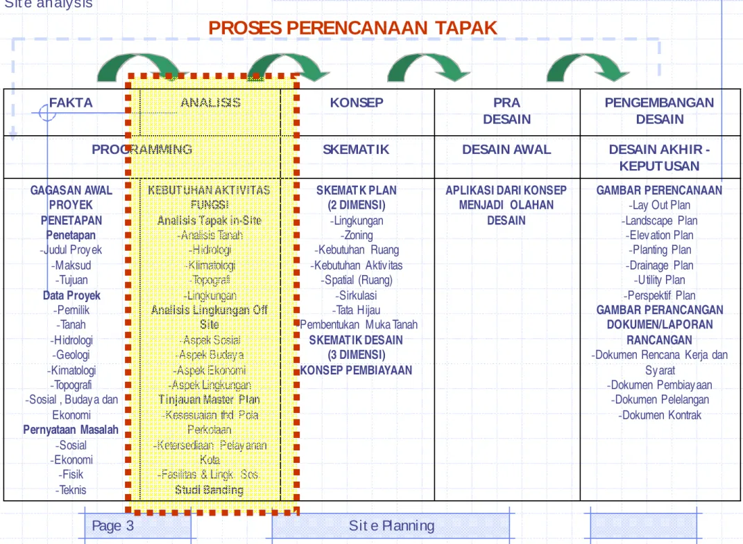
FAKTA ANALISIS KONSEP PRA DESAIN
PENGEMBANGAN DESAIN
PROGRAMMING SKEMATIK DESAIN AWAL DESAIN AKHIR -
KEPUTUSAN GAGASAN AWAL
PROYEK PENETAPAN
Penetapan -Judul Proyek
-Maksud -Tujuan Data Proyek
-Pemilik -Tanah -Hidrologi
-Geologi -Kimatologi
-Topografi -Sosial , Budaya dan
Ekonomi Pernyataan Masalah
-Sosial -Ekonomi
-Fisik
KEBUTUHAN AKTIVITAS FUNGSI
Analisis Tapak in-Site -Analisis Tanah
-Hidrologi -Klimatologi
-Topografi -Lingkungan Analisis Lingkungan Off
Site -Aspek Sosial -Aspek Budaya -Aspek Ekonomi -Aspek Lingkungan Tinjauan Master Plan
-Kesesuaian thd Pola Perkotaan
-Ketersediaan Pelayanan Kota
-Fasilitas & Lingk. Sos.
SKEMATK PLAN (2 DIMENSI)
-Lingkungan -Zoning -Kebutuhan Ruang -Kebutuhan Aktivitas
-Spatial (Ruang) -Sirkulasi -Tata Hijau
-Pembentukan Muka Tanah SKEMATIK DESAIN
(3 DIMENSI) KONSEP PEMBIAYAAN
APLIKASI DARI KONSEP MENJADI OLAHAN
DESAIN
GAMBAR PERENCANAAN -Lay Out Plan -Landscape Plan
-Elevation Plan -Planting Plan -Drainage Plan
-Utility Plan -Perspektif Plan GAMBAR PERANCANGAN
DOKUMEN/LAPORAN RANCANGAN
-Dokumen Rencana Kerja dan Syarat
-Dokumen Pembiayaan -Dokumen Pelelangan
-Dokumen Kontrak
Sit e analysis
Sit e Planning Page 4
2. ANALI SI S TAPAK ( SI TE ANALYSI S )
Proses pemahaman kualitas tapak dengan
mempertimbangkan
faktor-faktor
yang mempengaruhikarakter tapak
, dengan memadukanprogram kebutuhan.
Fungsi/ tuj uan
:•Menyesuaikan tapak dengan program
•Memelihara lingkungan alami
Pandangan:
• Ahli teknik
• Petani/ ahli pertanian
• Pengembang/ kontraktor
Orient asi:
• Terhadap tujuan
• Terhadap tapak
PROSES ANALI SA TAPAK
Sit e analysis
Sit e Planning Page 6
MAKSUD
1. Melayani keperluan fungsional manusia 2. Melayani keperluan
rekreatif
3. Menjaga proses alam (lingkungan
fisik/ biologis)
1. Potensi tapak: dapat digunakan sebaik mungkin (sumber-sumber, view, dll
2. Persoalan tapak: yang diperhatikan, vulnerable, perlu upgrading/
improvement
3. Fitur tapak:
keistimewaan yang khas, menyenangkan, harus dilindungi
4. Tanda bahaya: harus dihindari pematangan mahal
KATEGORI
LI NGKUP
Garis besar analisis:
• Lokasi (eksternal)
• Atas permukaan tanah
• Permukaan tanah
• Bawah permukaan
Unsur analisis:
1. Lokasi
2. Lingkungan
3. Ukuran dan peruntukan
4. Status lahan dan peraturan
5. Fisik dasar
6. Fisik binaan
7. Sirkulasi
8. Prasarana
9. I ndra (sensory)
10. Penduduk dan budaya
11. I klim
12. Dsb..
Sit e analysis
Sit e Planning Page 8
FAKTOR- FAKTOR ANALI SI S TAPAK
ALAM
• Air
• Topografi
• Orientasi
• Vegetasi
• View
• Drainase
• dsb
BUATAN
• Lokasi
• Peraturan/
• kebijakan
• Prasarana
• Fasilitas
• Bangunan
• Jalan/
sirkulasi
• dsb
PENGGUNA
• Karakteristik pemakai
• Kebutuhan ruang
• Program kegiatan
• dsb
1.
Analisis terhadap
Pemakai
Karakteristik pemakai dianalisisdigunakan u.
menentukan kebutuhan dan aktivitas ruang.
2.
Analisis thd lingk.
Alamiah
Elemen2 alami dan keadaan tempatsekitar tapak (iklim, air, tanah, topografi,
vegetasi, dan kehidupan makluk lainnya)
3.
Analisis Lingk. Binaan
semua data dr elemen buatan manusia dlm tapak, mis;
bangunan, drainase, dll. u/
mengetahui, memahami &
mengenal konsepsi ruang, sirkulasi ,dll.
4.
Analisis thd. Sosial,
Budaya dan Lingk. Sekitar
dijadikan pertimba-ngan dlm menentukan zoning dan aktivitas kegiatan yg
dirancang.
FAKTOR- FAKTOR ANALI SI S TAPAK
Sit e analysis
Sit e Planning Page 10
KI ND OF I NFORMATI ON
•
LOCATI ON
. Mayincude state map and city map showing
location of site in relation to city as a whole.
•
NEI GBORHOOD.
Presents the immediate surroundings of the site perhaps three to four blocks beyond the site boundary.
•
SI TE AND ZONI NG.
Document all
dimensional aspect of the site including
boundaries, location and dimension of
easements and present zoning classification with all its dimensional implications (set back, height restrictions,
parking formulas, allowed uses, etc)
May incude May incude state map and state map and
city map city map showing showing
location of site location of site
in relation to in relation to
city as a city as a wholetre wholetre
LOCATI ON
Site analysis Site PlanningPage 12
L O C A T I O N
LOCATI ON
DI AGRAM
Sit e analysis
Sit e Planning Page 14
NEI GBORHOOD
Present s t he immediat e Present s t he immediat e surroundings of t he sit e surroundings of t he sit e
perhaps t hree t o four perhaps t hree t o four blocks beyond t he sit e blocks beyond t he sit e
boundary.
boundary.
Sit e analysis
Sit e Planning Page 16
SI TE AND
ZONI NG
KI ND OF I NFORMATI ON
•
LEGAL
.this category the legal description of the
property, convenants
and restrictions, present ownerships, present
government jurisdiction (city or cunty) and any feature project (such as the fact that the site is in future city urban
renewal)
•
NATURAL FEATURES
. contours, drainagepatters, soil type and bearing capacity, trees, rocks, ridges, peaks, valleys, pools and ponds.
•
MAN-MADE FEATRUTES
.Buidings, walls, drives, curb cuts, hidrant,
power poles, paving pattern
Sit e analysis
Sit e Planning Page 18
The majority of
information in this category requires direct observation
of the site and recording the data over a topographic
survey showing site contours. Topographic features such as high point,
ridges, valleys, sloped and flat area. Drainage pattern
also involve direct observation.
NATURAL
FEATURES
KI ND OF I NFORMATI ON
•
CI RCULATI ON,
present all vehicular &
pedestrian movement patters on and around the site. Data includes duration and peak loads for surroundings
vehicular traffic and pedestrian movement, bus stops, site access adges, traffic
CLI MATE
• Temperature variation over the months of the year
• Humidity
• Rainfall
• Prevailing wind directions for the months of the year including velocity.
Sit e analysis
Sit e Planning Page 20
Present all vehicular &
pedestrian movement patters on and around the site. Data
includes duration and peak loads for surroundings
vehicular traffic and pedestrian movement, bus
stops, site access edges, traffic generators, etc.
CI RCULATI ON
Sit e analysis
Sit e Planning Page 22
UKURAN & WILAYAH
Sit e analysis
Sit e Planning Page 24
SIRKULASI
Sit e analysis
Sit e Planning Page 26
PANCAINDERA
M ANUSIA & BUDAYA UTILITAS
Sit e analysis
Sit e Planning Page 28
SUPERI MPOSE
Sit e analysis
Sit e Planning Page 30
PENGEMBANGAN DESAIN
DENAH KONSEP
Source: Wang 2001
Sit e analysis
Sit e Planning Page 32
Resort (Sasaki Assoc.)
Source: Wang 2001
Peter Creek: Alternative One Peter Creek: Final Plan
Sit e analysis
Sit e Planning Page 34
References:
• Lynch, Kevin; Gary Hack (1984). Site Planning. Cambridge:
The MI T Press
• Reid, Grant W. (2001). Grafik Lansekap. Trans. P.H. Adj ie.
Jakarta: Erlangga
• Wang, Thomas C. (2001). Gambar Denah dan Potongan. Trans. N.T. Harwadi. Jakarta: Erlangga
• Hakim, Rustam (2000). Penyaj ian dan Tahapan Perancangan Arsitektur Lansekap. Jakarta: Penerbit Universitas Trisakti.
Cet. Ke-2.
• White, Edward T. (1985) Analisis Tapak: Pembuatan Diagram I nformasi bagi Perancangan Arsitektur.