CONTENTS
4 CONTENTS
ANNOUNCEMENT
8 ANNOUNCEMENT
H. Holmes, Chief
ANTIQUITIES OF THE JEMEZ PLATEAU,
NEW MEXICO
INTRODUCTORY NOTE
PHYSIOGRAPHY OF THE JEMEZ PLATEAU
32 Theleadino;topographical features of the whole area are mountains, characterized by massive rounded contours, the highest peak reaching a height of 11,200 feet; flat mesa-lands at an altitude of 7,000 to 8,000 feet, cut by innumerable ravines from 100 to 1,500 feet deep, the undulations sloping gently from the mountains to the valleys, on the borders of which they terminate in bold perpendicular slopes (pi. i) ; and narrow sandy valleys at elevations from 6,000 to 7,000 feet. This region became the seat of a significant population in prehistoric times, and almost countless ruins of the ancient civilization are distributed throughout the Pajarito Plateau, the Chama drainage and the Jemez Valley. The selection and preparation of land for agriculture naturally tended towards permanent residence, and the peculiar geological conditions naturally determined the character and construction of the people's dwellings.
ARCHEOLOGICAL REJVIAINS
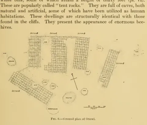
A considerable advance over this type is shown in the entirely artificial dwelling excavated in the perpendicular face of the cliff (pi. ii, h), the front wall being formed of the natural rock in situ. It is clear that when they were used, the majority of these dwellings were made much more furnished by building porches, as shown in the restoration (pi. iii, h) in front of the excavated rooms. These cliff-dwellings occur in large numbers on the southern faces of the tongue-like mesas (potreros) of volcanic tufa, which terminate from the base of the mountain toward the valley of what is known as the Pajarito Plateau, the tableland lying between the Jemez- area and the Rio Grande.
They exist in great numbers on the Pajarito Plateau from Cochitin to the other of the table-land overlooking the Chama Valley; in the valleys of the northern tributaries of the lower Chama; on those as both north and south of upper Chama, especially in Gallina's "bad lands"; and in the Jemez Valley.
THE ANCIENT INHABITANTS
HEWETTJ ANTIQUITIES OF THE JEMEZ PLATEAU 13 present site. Their traditions indicate a residence at this site of as
DISTRIBUTION OF THE RUINS
Ruins of the Pajarito Plateau
This name, the Pajarito Plateau, suggested by the writer some years ago and now generally adopted, is applied to the table on the eastern side of the Jemez Mountains. The name is usually confined to the region lying east of the mountains which border it to the east. A considerable portion of the plateau was originally covered by a sheet of volcanic tuff, varying in thickness from 100 to 1,000 feet.
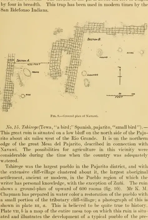
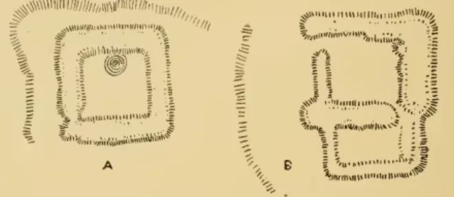
Sliujinne (fig. 1). This is a small pueblo ruin with an associated cliff village, located on a high mesa that rises abruptly above the plateau on the north side of the Santa Clara Gorge, about ten miles west of the Santa Clara Village.
ANTIQUITIES OF THE JEMEZ PLATEAU 15
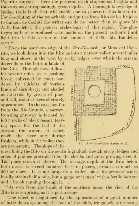
126 FEET
The second type (pi. ii, h) is entirely artificial, with closed front of the natural rock in situ. Sandia.—This village is situated on a high mesa between the Sandia and Bear canyons, and is one of the most commanding. It is on the northern edge of the great Mesa del Pajarito, described in connection with Navawi.
Chapman has a restoration of the Pueblo with a small portion of the tributary cliff village in water preparation; a picture of this is.
24 BUREAU OF AMERICAN ETHNOLOGY [BULL. 32
HEWETT] ANTIQUITIES OF THE JEMEZ PLATEAU 25 length, etched on the rock by peckmg with a stone implement. The
HEWETT] ANTIQUITIES OF THE JEMEZ PLATEAU 25length, etched on the rock by peckmg with a stone tool. 34;As seen from the edge of the southern mesa, the view of the Ritoisasssurprisingasit is picturesque. Not only are the holes visible in which the ends of the supporting beams rest.
Two of them are in front of the caves at a short distance from the talus that slopes up to them.
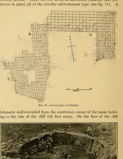
HEWETT] ANTIQUITIES OF THE JEMEZ PLATEAU 29
I recognized at a glance when I first saw them on the evening of October 25, 6:00 p.m., the intention to represent panthers preparing for a spring. At the south-east corner is an opening one meter (39 in) wide, forming the entrance to a passage flanked by two stone hedges like the enclosure, which runs out to the south-east for a distance of 5.85 meters (19 ft). No.23.LaCueva Pintada {"the painted cave''),platex,h.—''In the canyons both north and south of Potrero there are a number of artificial caves.
Those to the north, at Canada Honda and at the top of Canondel Alamo, are well preserved. It doesn't offer anything worth mentioning, and don't compare it in numbers to the settlement in Rito. Those on the south side of Potrero de las Vacas are much more worn, and are connected with the interesting natural rock-shelter called by the Queres Tzek-iat-a-tanyi, and now commonly called Cueva Pintada, or painted cave.
The pictographs represent some of the well-known symbols of the pueblos, such as clouds, lightning, the sun, dancing shields, and male and female dancers. The cave dwellings were excavated in the back wall of the cave, and there are depressions 15 meters (48 feet) above the floor. HEWETT] ANTIQUITIES ON THE JEMEZ PLATEAU 31 showing that chambers were also excavated at this height.
HEWETT] ANTIQUITIES OF THE JEMEZ PLATEAU 31 showing that chambers had also been burrowed out at this height
Ruins of the Chama Drainage
The Rio Chania flows into the Rio Grande near the Mexican village of Chamita, about a mile west of the Indian village of San Juan. In describing the antiquities of this basin it is convenient to consider first the ruins of the plateau on the south side of the Chama between the Rio Grande and the Pedernal peak; secondly, ruins the valley north of the river as far as Abiquiu; thirdly, the ruins above Abiquiu. A succession of large pueblos occupied impressive sites on the northern edge of the plateau overlooking the Chama.
At this point a chain of loose fragments of the great Black Mesa (Mesa Canoa) crosses to the south side of the river and extends several miles southwest.
34 BUREAU OF AMEBIC AK ETHNOLOGY [BULL. 32
HEWETTJ ANTIQUITIES OF THE JEMEZ PLATEAU 35 the Chama river at a point known as ' 'La Pnenta," about 3 miles below
BUREAU OF AMERICAN ETHNOLOGY [bull. 32
It was a common observation that the erosion of the faces of these cliffs had undermined the foundations of the houses, so that their wall stones, with the posts, were mixed with pottery on the talus below. Most of them had been undermined, and the stones lay in quantities on the talus at my time. At one end of the line it appeared that the bases of two rectangular walls, perhaps of towers, were placed as supports for the terrace.
Pillars of very dry cedar occur among the ruins, and three such, standing upright on the top of the rock, mark a spot still untouched by the dissolution of the rock. The number of buildings to a square mile of that region is equal to not more than the number now existing in the most densely populated rural districts of Pennsylvania and New.
Ruins of the Jemez Valley'*
HEWETT] ANTIQUITIES OF THE JEMEZ PLATEAU 45 The early days of Spanish occupation of the Jemez country, 1540.
HEWETT] ANTIQUITIES OF THE JEMEZ PLATEAU 45 The early days of Spanish occupancy of the Jemez country, 1540
The buildings are irregular in plan and consist of three groups, the entire length of the groups being approximately 130 meters and the width 100 meters. A sketch plan is given in Figure 26. Patokwa.—Two ruined pueblos, extremely interesting from their connection with the events of the Spanish conquest, are found at the confluence of the two main branches of Jemez creek, six miles above the present Jemez pueblo. Part of the ruin is a large pile of rubble from which the larger stones have been removed.
That this structure is of late date is clearly indicated, not only by the state in which it has been preserved, but also by the presence on one corner of the ruins of a Catholic church. . . aThe measurements in this article by [Professor Holmes] are all estimates only, and the orientation is only approximate. . hewett] ANTIQUITY OF THE JEMEZ PLATEAU 47 . \O. It is an interesting fact that along the edges of the abyss there are traces of defenses built of stone. The tower and its upper parts are made of the impure friable limestone of the promontory against which the foundations are built.
The lower end of the church and the walled enclosure extend to the border of the arroyo and the latter is built of heterogeneous materials. The eastern houses of the pueblo almost touch the western walls of the church, and from this structure one could overlook the village and part of the valley and the sides of the mesas. easily scanned. Fig. 2ii.-Planimetry of Amoxi- f^om the edge of the canyon, and from . its aglimpse walls may be of the lower Jemezcreek valley.
Some of the interior of the room is exposed and still retains the plaster coverings, and the ceilings are also made of logs. HEWETT] ANTIQUITIES FROM THE JEMEZ PLATEAU 49transverse layers of brush or splinters to support the soil cover-.
HEWETT] ANTIQUITIES OF THE JEMEZ PLATEAU 49 transverse layers of brush or splinters to support the earthen cover-
30 feet wide and 150 feet in length, and in places six feet in height, . the characters present in the main part identical to those of the central structure. In the space between the two clusters is a third circular depression, corresponding in size to those previously mentioned. On the south, separated from the corner of the shorter wing of the main building by a space about 10 feet wide, is a fourth mass of rubble, d, about 40 feet in breadth by 120 feet in length, the lower end of which extends to the edge of the terrace.
49. —Sixteen miles above Jemezpueblo, on a low sloping terrace on the west side of the valley and 100 to 130 feet from the creek, is a small pueblo group of the usual type (Fig. 31). They generally consist of a single room, rarely of two or more rooms, and the dimensions of the apartments rarely exceed three or twelve feet. The walls are thin and loosely constructed, and today they are rarely more than three feet high, the lack of rubble indicating that they could never have been more than one story high.
These houses occur in considerable numbers in the valley of the San Diego near the great bend, 20 miles above Jemez pueblo; near the warm one. The existence of other important ruins that are exceptionally well preserved from the high Valle Grande and San Antonio Valleys on the eastern edge of the Jemez Basin have been reported; also from the foothills of the Nacimiento Mountains in the upper Guadalupe.
MINOR REMAINS OF ANTIQUITY
HEWETT] ANTIQUITIES OF THE JEMEZ PLATEAU 53
THE PRIVILEGE OF EXCAVATION
Although carried out by the Senate and House of Representatives of the United States of America assembled in Congress, provides that any person who possesses any historic or prehistoric building or monument, or any object of antiquity, situated on land owned by or controlled by the United States Government, will appropriate, excavate, deface, or destroy without the authorization of the Secretary of Justice. The department of the Government having jurisdiction over the lands on which the said antiquities are located, shall, upon conviction, be fined not more than five hundred dollars and imprisoned for a term not exceeding ninety days, otherwise they will suffer both a fine and a prison sentence, at the discretion of the court. uniform rules and regulations for the implementation of the provisions of this law. BUREAU FOR AMERICAN ETHNOLOGICAL BULLETIN 32 PLATE X . a STONE LIONS OF POTRERO DE LAS VACAS IREAR VIEW).