MIXTEC HOUSES
IN THE NOCHIXTLAN VALLEY, OAXACA
By
MICHAEL LIND
)
IN THE NOCHIXTLAN VALLEY, OAXACA
By
MICHAEL LIND
Copyright 1979
Vanderbilt Un1versity
~
Publicationsm Anthropology
If., ~,
i . 'f NO. 2.3
NASHVILLE, TENNESSEE' .. 1979 ~,0
This small monograph represents an ab'breviated and somewhat modified version of the first two chapters of my doctoral disser- tation entitled: Mixtec Kingdoms in the Nochi~tlan Valley: A Preconquest to Postconquest Archeological Perspective (Tucson:
University of Arizona, 1977). Here I should like to express my gratitude to a number of people who aided me by contributing t o the completion of my dissertation and consequently to this study.
My dissertation was directed by Dr. T. Patrick Culbert who patiently and expertly guided me through difficult stages of analysis and interpretation. Dr. Arthur Jelinek and Dr. William Rathje, members of my dissertation committee, made most helpful comments in reviewing my dissertation.
Dr. Ronald Spores offered me the opportunity to direct excavations at Chachoapan and Yucuita and has graciously aided me in every way possible to bring this study to completion. In the Summer of 1969, Dr. Kent Flannery helped me to clarify my research goals and develop an explicit research strategy prior to initiat ing fieldwork in the Spring of 1970.
In the field I was assisted by Richard Redding and Neal Byrd, two remarkably capable field assistants. I was fortunate in having most competent field crews from the villages of Chachoapan and
Yucuita. During the course of fieldwork discussions with other members of the Nochixtlan Valley Project -- Dr. John Broster,
John Warner, Lynne Dixon and Martha Symmes -- and with participants in other projects in Oaxaca -- Dr. Ignacio Bernal, Dr. John Paddock, Dr. David Peterson, Dr. Donald Brockington, Maria Jorrin, and
Dr. Marcus Winter -- were most helpful. In particular, Dr . . John Paddock graciously contributed his unequalled expertise on Oaxaca
archeology by critically reviewing and commenting upon my dissertation.
ii
bility for any errors in this study.
iii
LIST OF FIGURES .
. . . . . .
1. INTRODUCTION
. . . . . . . . . . . . . . . . . . . .
The Geocultural Setting. • . . . .
Mixtec Kingdoms -- An Ethnohistoric Model. . Chachoapan and Yucuita . • • . . 2. NOBLE HOUSEHOLDS AT YUCUITA .
.
.. . . . . .
The Natividad House . • • • . . . The Natividad Midden and the Terrace Walls . The Endeque House. . . • . . • . . . . • The Limestone House . . . " . . . • . . The Convento House . . . . • . . • • .
Summary . • • • .
. . .
3. NOBLE HOUSEHOLDS AT CHACHOAPAN • . The Endeque House . • .
The Limestone House . . The Convento House . Summary . . • . • . •
. . . . . . . . . .
. . . . . . . . . . .
4. THE SOCIOCULTURAL DIMENSIONS OF MIXTEC HOUSES.
Peasant and Noble Households . . • . . . . . Noble Rural and Urban Households • . . • Royal and Noble Households . • . .
Conclusions.. . . . . • . . . REFERENCES . . . . • . • . . . .
iv
. .
. . . . . . .
. ."
Page
v
1 2
4 12
17 18 17 18 28 32 32
39 41 42
52 57
63 64
65
66 67 731. Map of the Mi,xteca and Surrounding Regions.
· .
2. Map of the Mixteca Alta . . .
· . .
3. Map of the Nochixtlan Valley . •
4.
5.
Yucuita Arm of the Nochixtlan Valley.
. . . . . . . . .
Ruins of an Early Colonial Church at Chachoapan 6. Yucuita -- Excavation Unit N203J.
7. Excavation Unit N203J -- Composite of Features.
8. Yucuita: Natividad House - Natividad Midden • • . 9. Yucuita, Natividad House: Broken Jar on Floor . .
10. Yucuita, Natividad Midden (F-IOA) .
· . .
11. Yucuita: Terrace Walls . • •
. . . · . · . . . .
12. Yucuita, Staircase (F-14) .
. . . . . . . . .
13. Yucuita: Endeque House
. .
•·
• • • •· · ·
14. Yucuita, Endeque House: North Wall of East Room.
· · ·
15. Yucuita, Endeque House: East Wall of Northeast
Vestibule
· · · · ·
16. Yucuita, Endeque House: North Wall of Northeast
Vestibule
·
• •· ·
17. Yucuita, Endeque House: West Wall of Northeast
Vestibule •
·
•. . ·
18. Yucuita, Limestone House: Northeast Vestibule.
·
19. Yucuita: Limestone House
. . . . . . . . . . · . .
vii 3
8 13 16 16 19 20 21 21 22 24 25 26 26 27 27 29 30 20. Yucuita, Limestone House: Three Superimposed Floors.. 31 21. Yucuita, Limestone House: East Vestibule . .
· . . . .
31v
· ·
23. Yucuita, Convento House: Convento Midden (F-lO) .
· ·
• 3324. Yucuita, Convento House: Convento Midden Deposited
over wall
·
3425. Yucuita, Convento House: Sherds in Convento Midden 34 26. Chachoapan, Las Flores Burial •
·
• •· · · · · ·
4027. Excavation Unit N205K -- Composite of Features
· · · ·
4428. Chachoapan: Endeque House.
. · · · · · · · · ·
• •· ·
4529. Chachoapan, Endeque House: Wall along North Room
·
4630. Chachoapan, Endeque House: Limestone Wall.
· · · · · ·
4631. Chachoapan: Endeque House-II
· · ·
•· ·
4732. Chachoapan, Limestone House: Extension along North
Wall.
· · ·
4833. Chachoapan, Limestone House: Porch (F-28) .
· · · ·
•·
4834. Chachoapan, Limestone House: Early Postconquest
Midden.
·
4835. Chachoapan: Limestone House-I.
· · ·
•· · · · · ·
4936. Chachoapan: Limestone House-II 50
37. Chachoapan, Limestone House: North Courtyard
· ·
5138. Chachoapan, Limestone House: White Plaster
· ·
• 5139. Chachoapan, Limestone House: Eastern Half
·
•·
5140. Chachoapan, Limestone House: West Room
· · · · · ·
5141. Chachoapan: Convento House
. · · ·
• • 5342. Chachoapan, Convento House: View Towards East.
· · · ·
5443. Chachoapan, Convento House: West Courtyard
·
5544. Chachoapan, Convento House: Endeque Drain
· · ·
55vi
~ --- I
~; .... ' : - - - -.... ....,'..-,., \ \ Coxcatl!1n
"
,/ "\ Aca tl!1n
>. J , • ./ .-.-'
I "'~""" • / ". \ ~' ...
I .~ : ( '" /'
I . . . , \ \.'" Oji tl!1n
•
t - - . . . . ~
'" .-._._';" 'I '. "
... _.,.,.\ .J \' .... ". ... \
ChinantlaUsila
, ...
./.
...;,. \r ' , ' Huajuapa.n\. '7-_ ... Cuicatlc1n
I , .,. ,/ ... ,.. • Valle.
, J . '. . . . ; .... '"~
I
i
Tamazulapan ' _ . . . . " ~\ • I ... COlxtlahuaca ,,~'" • Yolox
Nacional
, ( I ~ '- v~
I ) BAJA ,,/ • ". ". Yanhui tMn ' \
" \. IITeposcolula ... NochixtMn J
\ '"' • I'
I ~ "
\ )Juxtla - . "
\ (huaca. / Tilantongo ... . ..
/~
Hui tzo" \ l._, \
( Tlaxiaco. .
"I'~ :'/....
"1. Oaxaca' ' . ' ''''---... , ---~ '", \ , M t I " on e · ' .. ...
\ ') \ ALTA /AI'OO.n • Lamb i i:'" Yagul
\ • I I . tyec()""~ •
\ . I : /
Zaachila M~ tlaI ( \ I :
I j \ / '.
/
",' \./ ... .
... / / . \ I
, . ; . 1 , /
Guerrero
,. "....-- , I
/ / COSTA---r
Oaxaca
" ,
a I
! ! !K i I 0 mete rs
\
\Tututepec I J
•
I I,
IOcean 100
I
Fig. 1. Map of the Mixteca and Surrounding Regions --- ... Limi ts of the Ancient Mixteca
- ' - ' - Present-day State Line ... Pan-American Highway
vii
INTRODUCTION
Discovering archeological evidence which might shed light on the origin of Mixtec kingdoms is one of the primary goals of the Nochixtlan Valley Project. The Nochixtlan Project, directed by Dr. Ronald Spores of Vanderbilt University, is a multidisci- plinary study aimed at integrating archeological, ethnohistoric, ethnographic, and ecological data to further an understanding of the origin and evolution of Mixtec culture in the Nochixtlan Valley located in the State of Oaxaca, Mexico. From studies of documents written by Spanish administrators and priests, who first entered the Nochixtlan Valley during the sixteenth century, Spores (1967:
1974ab) has reconstructed the nature of Postconquest Mixtec king- doms. Archeological evidence is necessary, however to reveal the nature of Preconquest Mixtec kingdoms.
From stratigraphic excavations in the Nochixtlan Valley, Spores (1972; 1974c) has defined five archeological phases which span three thousand years of Mixtec culture history: Cruz (1300- 200 BC), Ramos (200 BC - 500 AD), Las Flores (500-1000 AD), Nativi- dad (1000-1520 AD), and Convento ' (1520-1820 AD). Spores hoped that material manifestations of Mixtec kingdoms could "be identified archeologically, first for the European contact period ffionvent2J, then for protohistoric LNatividaQ7 and prehistoric times" (Spores 1972:4). From March to August of 1970, when the Nochixtlan Project received funding from the National Science Foundation, Spores gave me the opportunity of obtaining some of the necessary archeological
evidence by placing me in charge of excavations at Chachoapan and Yucuita.
1
villages in the Nochixtlan Valley, have roots in Prehispanic Mixtec settlements. The hillsides adjacent to each village are covered with the archeological remains of these Prehispanic Mixtec settle- ments. Excavation in these hillside ruins revealed a series of superimposed house remains which span a period from Preconquest Natividad to early colonial Convento times. This study presents an analysis of the architectural remains of these houses. Its primary objectives are to place the social groups who built and occupied these houses within the context of Prehispanic and early colonial Mixtec society.
The Geocultural Setting
At the time of the Spanish Conquest Mixtec society encom- passed the Mixteca Alta, Baja, and Costa regions of southernmost Puebla, easternmost Guerrero, and the northwestern third of Oaxaca
(Fig. 1). Situated in the broad Mesa del Sur of the Sierra Madre del Sur mountains, the Nochixtlan Valley lies in the heart of the Mixteca Alta (Fig. 2). Agriculturally richest and most populous
of the high mountain valleys pf the Mixteca Alta, the Nochixtlan Valley forms a 600 sq. km. drainage basin immediately west of the
Continental Divide.
Sixteenth century documents refer to the agricultural rich- ness of the Nochixtlan Valley (Paddock 1964). The Mixtecs had constructed a complex series of terraces transforming hillside gullies into fertile fields. This lama bordo terrace system
involved building a series of terrace walls across the course of the erosion channel which resulted in a series of check dams creating a staircase effect (Spores 1969). Sediments eroding
from the hillsides into the gullies were trapped behind successive terrace walls and much of the water carrying these sediments was absorbed creating rich humid fields. Combined with well-watered alluvial valley bottomlands, the fertile lama bordo terrace fields
\. r-- \
\ ' \
~
..~j~~
••••• I,J
C01xt1ahuaea"
,"
•••• , •• I I I. , t ,
... I Huautla I
···l.
Tamazu1apan • 1BAJA I I .... •...•. Tejupan Apoala • I
/ ~. t
".--- - ... Soya1 tepee I
, ' . .
.;'~,
, . . . ' • voyotepee I
.. I '
I Teposeo1u1a '\"",._._ • • Chaehoapan I
/ ' •
Yanhu{~l~·r..
•Yu~;
ta "I ( ... Yueueu1'
~
lTl·1 tepee ... . ,NO:~..ixt1an
:,
\. .
\ Etlatongo \ / ~ / Sosola I,
\ Yodoeono I~I
•
\ Aehlut1a \ " ~ . ,
\ • ·!'·<J"a1 tepeQ. I
~ Atoyaqul110. Yueuafie
\,!./ ... .f.._.
, • • I
I.
T11antongo ,, Tlaxlaeo I
I I
I ,
, I
I ALTA I
, • I
\ Tamazo1a I
\ I
\ I
\ I
, Cha1eatongo Teozaeua1eo I
I, • • I
\ • I
\ ~, Yo1otepee I I
"
~COSTA
-~
,
". " . '\. ~~
\. Amo1tepee ,.-
\. ".
\.
, , .
~~ ~~\._~--~
o
I ; , , ; Kilome t e r s F1g. 2, Map of the Mlxteea Alta2S I
lands and gently sloping valley margins were much less productive as farmland (Kirkby 1972:47).
Because of frequent winter frosts, the farming season in the Nochixtlan Valley is limited from March to October. In rich humid alluvial valley bottomlands and lama bordo terrace fields corn is planted by the cajete technique in March. The cajete technique involves planting corn deep within the soil where it is sustained by humidity for two months prior to the onset of the rainy season, which begins in· late Mayor early June. This deep planting gives the corn
a
longer growing season and yields a rich harvest. The lack of humidity in hilltop fields and fieldslocated in the gentle slopes along the margins of the valley means that these fields cannot be planted until just before the onset of the rainy season in May. Thinner soils and a shorter growing season result in lower yields in these fields.
Sixteenth century censuses suggest that communities in the Nochixtlan Valley might be grouped into four categories with
regard to population size (Table 1). While by no means definitive, since population figures are open to question and smaller commu- nities were rarely included in the censuses, these categories include: (1) urban centers, (2) towns, (3) villages, and (4) ham- lets. Understanding how these different types of communities were organized and how they were able to structure their interrelation- ships with one another calls for an understanding of the nature of Mixtec kingdoms around the time of the Spanish Conquest.
Mixtec Kingdoms An Ethnohistoric Model
From analyses of scores of documents pertaining primarily to the large Nochixtlan Valley urban center of Yanhuitlan, but also to other communities in the Nochixtlan Valley and surrounding areas of the Mixteca Alta, Baja, and Costa, Spores (1967; 1974ab)
Communities
Table 1
POPULATIONS OF SOME SIXTEENTH CENTURY COMMUNITIES IN THE NOCHIXTLAN VALLEY (Adapted from Dahlgren 1954:36-37)
16th-Century Census
of Tributarios Population Estimate (Household Heads) (Tributarios x 4) Urban Center
Yanhuitlan 6000 24000
Towns
Jaltepec 1500 6000
Nochixtlan 1000 4000
Villages
400 1600
Chachoapan
Yodocono 360 1440
Tiltepec 300 1200
Etlatongo 300 1200
Hamlet
Yucucui 90 360
has developed an ethnohistoric model of Mixtec kingdoms as they existed at the time of the Spanish Conquest. Mixtec kingdoms were composed of either a single community or, more commonly, of several communities in which one was the principal center
(cabecera) and the others subject to it (Spores 1967:100-101).
Although hamlets were always subject communities and urban centers and towns consistently cabeceras, some villages were cabeceras while others were subject communities. No simplistic correlation existed, therefore, between the size of a community and its status as a cabecera or subject community.
Cabeceras in the Nochixtlan Valley and elsewhere in the Mixteca fell into three main categories with regard to population size: (1) urban cabeceras, (2) town cabeceras, and (3) village or rural cabeceras (Fig. 3). Villages which were rural cabeceras generally lacked subject communities being kingdoms in themselves, while larger town cabeceras usually had several subject communities and the even larger urban cabeceras had a very large number of
subject communities. However, a direct correlation between the size of a cabecera and the number of its subject communities did not exist. Some rural cabeceras had as many as eight subject
communities, while some town cabeceras lacked subject communities being kingdoms in themselves.
At the time of the Spanish Conquest, Chachoapan was one of
SlX communities in the Nochixtlan Valley which were cabeceras of kingdoms. Included among the remaining five cabeceras were
Tiltepec, Etlatongo, Jaltepec, Nochixtlan, and Yanhuitlan (Fig. 3).
Chachoapan and Tiltepec were both rural cabeceras of kingdoms which lacked subject communities. Etlatongo was also a rural cabecera but of a kingdom that had eight subject communities.
The towns of Nochixtlan and Jaltepec were cabeceras of kingdoms
which had four and six subject communities respectively. Yanhuitlan, the only urban cabecera in the Nochixtlan Valley, was the cabecera
of a kingdom that had sixteen subject communities -- one of which was Yucuita (Spores 196~:lOO-lOl).
The cabecera was the primary political, economic, and religious center of the kingdom. The king (cacique) or queen
(cacica) of the kingdom resided within a large palace in the cabecera. The cabecera was divided into neighborhoods (barrios) each of which was administered by a noble appointed by the ruler.
These nobles were often the ruler's brothers or other close relatives who resided in the barrios they were chosen to govern
(Spores 1974a:305-306; D~hlgren 1954:171). The barrios of the cabecera were occupied by commoners who were required to pay tribute and labor services to the nobles and ruler who governed them. The cabecera contained the. main marketplace of the kingdom and the primary ceremonial precinct (Spores 1967:94).
The relationships between the cabecera of a kingdom and its subject communities were structured in a manner that is somewhat similar to the organization of a cabecera. The ruler appointed a noble, who was usually a close relative, to reside in the subject community and to collect tribute from the commoners who occupied the community. The cabecera of a kingdom, then, mani- fested three social classes including (1) royalty, a cacique or cacica and their family of procreation, (2) nobles, and (3) com- moners (Spores 1974a:300-301). Subject communities, on the other hand, had only two social classes -- nobles and commoners (Spores 1967: 94) .
Throughout the Mixteca Alta, Baja, and Costa regions and even into the traditionally Zapotec Valley of Oaxaca, Mixtec rulers structured the interrelationships between their kingdoms and other kingdoms by means of complexly arranged marital alli-
·ances (Caso 1966; Spores 1974a). The manner in which ruling
families established these alliances is clearly stated in Spanish
• coyotepe~ Perales
~ ~
'.. \(
'.
,
'.' "'*YanhU1
tl~n *
lhaChoapan • AmatlM".
'
. .
'."
.
• "~uCh1xtl~n
T1ltepec
'.
'. ....
*
Tlllo•
... Yucucul
..
•... Sinaxtla
•••••
". ...
.. ... ... * .
Noch1xtlM " .-""-...-Andua
• •
Topiltepec
. . . .
'
.
Adequez
• •
Chlndua Tlach'tongo
Tlatayapan
•
Yodocono
•
Jal tepetongo•
o
5I ' , I
K1lometers
\\
· · · .
". Muma•
iZachl0
'. ·
:· .
· ·
· ... ...
,.'
. .... ....
l ":
· · · · .
Flg.
3.
Map of the Nochixtlan Valley (Adapted from Spores 1972:3)~ Rivers
... ,... Pan-Amer1can H1gh\,lay
• Rural Commun1t1es
*Urban Cabeceras
*
TOl'm Cabeceras*
Rural Cabeceras...
... .I-
colonial documents and depicted in Mixtec genealogical manuscripts (codices). In Preconquest and early colonial times each kingdom maintained in its cabecera a codex depicting the kingdom's subject communities and a history of its ruling caciques (Spores 1967:
94-96) .
Caso (1960) has succeeded in deciphering several of the extant Mixtec codices. Some of these, such as the Codex Bodley, depict the history of caciques, their wars and their marital alliances over a period of nearly a thousand years. From an analysis of the Mixtec Codex Bodley and Spanish colonial docu- ments, Caso (1966) has identified the rulers of the kingdom of Yanhuitlanand related them to the rulers of Chachoapan around the time of the Spanish Conquest. Shortly before the Conquest, Lady One Flower "Tiger-Quechquemitl" (Cauaco), cacica of Yanhuitlan, married Lord Eight Death "Tiger-Fire-Serpent" (Namahu), a brother of the cacique of Tilantongo (Caso 1966:313). Lady One Flower and Lord Eight Death resided at Yanhuitlan and produced five children. The three youngest, either by marriage or through inheritance, became caciques at Coixtlahuaca, Teozoatlan (in the Mixteca Baja), and Tiltepec (Spores 1967:133-34).
Around AD 1530, shortly after the Conquest, their oldest child, Dona Maria Coquaha (Two House) inherited the kingdom of Yanhuitlan and became its cacica. A marriage was arranged between Dona Marla and Don Diego Nuhq (Six Motion), cacique of the kingdoms of Tamazola and Chachoapan. Don Diego had inherited the kingdoms of Tamazola and Chachoapan from his older brother, Don Domingo Cuncusi, who had died childless (Spores 1967:116). The marriage of Don Diego to Dona Marla took place in Achiutla, religious center for all the Mixteca Alta in Prehispanic times. "The nobility gathered there and consulted among themselves and with the families concerned. It was decided at that time that the first child of the couple would inherit Tamazola-Chachoapan. The second child was to receive Yanhuitlan" (Spores 1967:146).
Together Don Diego and Dona Marfa resided in the rural cabecera of Tamazola and, although her remaining brother, Don Domingo de Guzman (Seven Monkey "Tiger-Torch") resided in
Yanhuitlan and looked after her interests there, she was still cacica of Yanhuitlan (Caso 1966:414; Spores 1967:134). Dofia Marfa and Don Diego produced two sons. The elder son took the name Don Matias de Velasco, while the younger son took the name Don Gabriel de Guzman. Early in the 1540s Dona Marfa died and her second born child, Don Gabriel, became cacique of Yanhuitlan in accordance with the agreement made at the time of his parents' marriage. Since he was only a child at the time of his mother's death, Don Gabriel was too young to rule. Therefore, he was sent to reside in Yanhuitlan under the tutelage of his uncle, Don
Domingo de Guzman, who reigned as cacique-regent. When his uncle died, Don Gabriel became the ruler of Yanhuitlan. Don Francisco de Guzman, Don Gabriel's son, inherited the kingdom of Yanhuitlan late in the sixteenth century, after his father's death, and ruled well into the seventeenth century (Spores 1967:134-38).
Also in accordance with the agreement made at the time of his parents' marriage, Don Gabriel's older brother, Don Matfas de Velasco, became cacique of the kingdoms of Tamazola and Chachoapan.
Don Matias continued to reside in Tamazola as did his son, Don Pedro de Velasco, who inherited the kingdoms of Tamazola and
Chachoapan upon his father's death and ruled into the seventeenth century (Spores 1967:116). During the sixteenth century, then, and for an unknown number of generations before, Chachoapan was a rural cabecera without a resident cacique. Don Domingo Cuncusi, Don Diego Nuhq, Don Matlas de Velasco, and Don Pedro de Velasco
all remained residents of distant Tamazola. Also throughout the sixteenth century and for an unknown number of decades before, Yucuita remained a subject community of Yanhuitlan.
Placing the Prehispanic and early colonial communities of Yucuita and Chachoapan within the changing context of Mixtec society requires reference to the history of Chachoapan, out- lined above, as well as application of Spores' ethnohistoric model. Deducing from the model, Chachoapan as a cabecera should manifest: (1) three social classes including royalty, nobility, and commoners; (2) barrios administered by resident nobles,
(3) a market place, and (4) a ceremonial precinct. However, Chachoapan's historical status as a rural cabecera without a resident cacique during the sixteenth century and for an unknown number of generations before requires modification of these
deductions.
The absence of a resident cacique makes it apparent that only two social classes -- nobles and commoners -- occupied Chachoapan throughout the sixteenth century. Furthermore, although barrios were numerous in urban and town cabeceras, rural cabeceras certainly manifested fewer barrios and it is possible that the nobles who governed these barrios resided
together instead of within the barrios because of the small size of the village community. Finally, the presence of markets and ceremonial precincts in rural cabeceras is not clearly documented;
and, if they did exist, their size must have been modest in com- parison with those in large urban and town cabeceras.
Applying the ethnohistoric model to Yucuita is even more difficult than applying it to Chachoapan. Yucuita, as a subject community should manifest: (1) status as a rural community, village or hamlet; and (2) nobles and commoners as the only two social classes. While these two deductions require no modifi- cations, they are as far as the model leads. There is no indi- cation whether or not subject communities manifested barrios, markets, or ceremonial precincts. It's likely that barrios, markets, and ceremonial precincts were absent in hamlets and, perhaps, villages, but present in the larger rural communities.
Perhaps the weakest point in the ethnohistoric model for the purpose of this study is that the interrelationships among the nobles within a kingdom are not specified. How nobles secured appointments as administrators, how they structured
marriage alliances among themselves, and whether or not they had the persuasion to secure positions for their offspring is unclear.
Complementary data are required to elucidate the behavior patterns of nobles and the content and composition of their households.
The extent to which material manifestations of these behavior patterns and others, which have been deduced from the ethno- historic model, exist in the archeological remains of the Pre- hispanic and early colonial communities of Chachoapan and Yucuita determines the extent to which archeological analysis can provide these complementary data.
Chachoapan and Yucuita
Archeological remains of the Prehispanic and early colonial communities of Chachoapan and Yucuita are located about two kilo- meters apart in the piedmont zone on opposite sides of the Yucuita arm of the Nochixtlan Valley (Fig. 4). The archeological remains of both communities cover an area of about one square kilometer, indicating that in Preconquest and early colonial times these two communities were of comparable status with regard to population size. Since sixteenth century censuses record the population of Chachoapan as 400 tributarios, or about 1600 persons (Table 1), Yucuita, whose population was not listed in the censuses, probably manifested a population of similar size.
The Prehispanic and early colonial community of Chachoapan sat astride two piedmont spurs. These spurs, known locally as Las Pilitas and La Iglesia Vieja, project from the base of a steep mountain called Cerro Verde atop which sit the famous Classic
ruins of Yucunudahui (Caso 1938). A large barranca or gully, pre- sently converted to fields by the lama bordo technique, separates
,.",
. "
iCOYOTEPECLas
0 1 2
! ! I
Kilometers
Fig. 4.
... ."..
•... - ....
· u.
N205
•
*
Yucuita.Arm of the Nochixtlan Valley
Limits between alluvial valley and piedmont Limits of major Las Flores occupation
Limits of major Natividad occupation Present-day communities
Site numbers Excavation units Obsidian workshops
the two piedmont spurs and provides Chachoapan today, as it must have in the past, with rich humid fields suitable for planting corn by the cajete technique.
Archeological remains of the Prehispanic and early colonial community of Yucuita are located on a long wide piedmont spur which extends from the base of a steep mountain called Cerro de las Flores whose summit supports impressive Classic remains. The piedmont spur delimits one side of a narrow valley which branches off the main Yucuita arm. This valley has the only perennial stream in the Yucuita arm of the Nochixtlan Valley -- the Rlo Perales. Although too small for any extensive irrigation, the Rio Perales makes the valley soil very humid and therefore superb for planting corn by the cajete technique. A seasonal stream, the Rlo de los Hermanos, bisects the alluvial valley between
Chachoapan and Yucuita. The deep valley soil also retains the humidity necessary for ca,jete planting.
The rural character of the Prehispanic and early colonial communities of Chachoapan and Yucuita is reflected in their archeological remains. There are few obvious indications of specialized industries within the communities. A total of four obsidian workshops was found at Yucuita and one was found at Chachoapan. Chachoapan was located near an extensive deposit of high quality chert which was intensively quarried in Prehispanic times. Yucuita had nearby deposits of hematite and limonite which may have been exploited as mineral pigments. Although possible marketplaces (plazas) occur at both communities, in the absence of intensive survey and extensive excavation it was not possible to confirm their existence (Fig.
4).
Surface survey revealed no apparent indications of Pre- conquest Natividad temple structures within either community.
However, excavations at Yucunudahui revealed a Natividad cere- monial complex indicating that portions of the large Classic ~
ceremonial center on the mountain top adjacent to Chachoapan wer.e utilize,dby the inhabitants of Chachoapan as a ceremonial. precinct in Natividad times (Spores, personal communication).
Furthermore, the ruins of a modest early colonial church occur within Chachoapan at La Iglesia Vieja (Fig. 5). The lack of comparable Prehispanic and early colonial ceremonial complexes at Yucuita is one, and 'perhaps the only, indicator of Chachoapan's status as a rural cabecera and Yucuita's status as a rural subject community.
Whether or not barrios existed within Chachoapan and Yucuita remains to be confirmed. The position of Chachoapan
astride two piedmont spurs probably provided a convenient division of the community into at least two barrios -- Las Pilitas (N237) and La Iglesia Vieja (N205). Likewise, at Yucuita, a present-day distinction between the Cerro (N203) and La Pena (N217) may have served in the past to define two barrios (Fig.
4).
However, the divisions between barrios are culturally determined and are rarely restricted to geographic boundaries alone.Excavation revealed that both communities had noble house- holds located high in the piedmont zone where more gentle slopes give way to steep rocky mountainsides. Extending from these noble residential zones down into the gently sloping piedmont were more modest dwellings of commoners. The presence of both noble and
commoner households at Chachoapan and Yucuita confirms the exist- ence of at least two social classes in both communities. Excavated remains of the Prehispanic and early colonial houses of nobles
located in the wealthy residential sectors of Chachoapan and Yucuita provide the archeological data for this study.
Fig.
5.
Ruins of an Early Colonial Church at Chachoapan. (Photo courtesy of Martha Symmes)Fig. 6. Yucuita Excavation Unit N203J: View toward East across Upper and Lower Terraces.
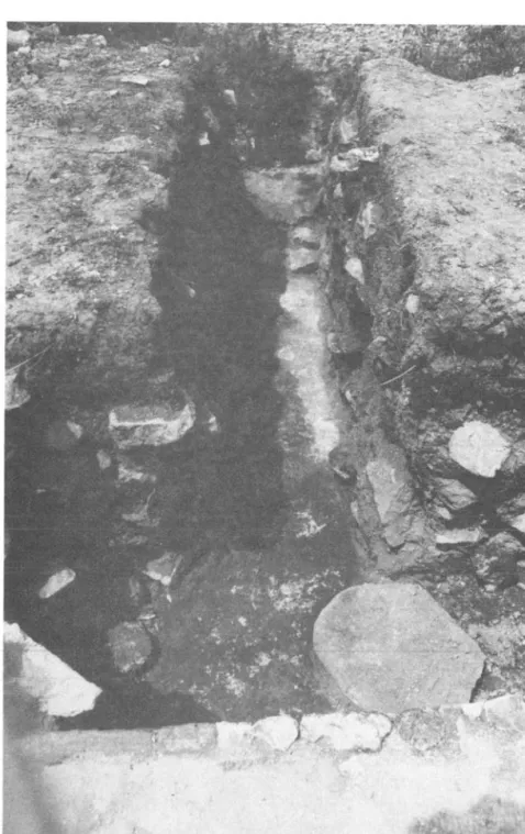
NOBLE HOUSEHOLDS AT YUCUITA
Excavation unit N203J encompasses parts of two man-made terraces located high in the piedmont zone at the base of Cerro de las Flores. Over four meters of occupational debris form the terrace fill. A half meter of early Classic Ramos deposits rests on bedrock. Above these deposits is a
15
cm. layer of sterile red tepetate followed by four meters of Natividad and Convento remains which consist of a series of superimposed floors,foundations, walls, and middens -- remnants of large houses that once occupied this locality (Fig. 6).
Most of the architectural features at N203J correspond to four houses: (1) a Natividad house built on the upper terrace in Natividad times, (2) a stratigraphically later endeque house built on the lower terrace in Natividad times and manifesting two stages of construction, (3) a limestone house built on the lower terrace around the time of the Spanish Conquest, and (4) a Convento house built on the upper terrace after the Spanish Con- quest. Recent pits, dug to obtain dirt for adobes, have destroyed at least two-thirds of the remains of the houses on the lower
terrace, leaving their northern third preserved in an irregular east-west section. In the not too distant past, the upper
terrace was farmed and the plow destroyed most of the Convento house (Fig. 7).
The Natividad House
The Natividad house, located on the upper terrace, was only partly uncovered in two small I x 2-meter pits separated from one
17
another by four meters in an east to west direction and excavated to a depth of two meters through the terrace fill (Fig. 8). The excavated remains include part of a box-shaped stone-lined hearth
(Feature 11)* set in a compact dirt floor and a section of lime- stone foundation (Fig. 9). The foundation, uncovered in the east pit, may represent the north wall of the room represented by the dirt floor and hearth (F-ll) which was uncovered in the west pit.
The floor, hearth, and foundation together probably represent a kitchen of the as yet incompletely explored Natividad house.
The Natividad Midden and the Terrace Walls
On the lower terrace, south of the Natividad house, is an extensive Natividad midden (Fig. 10). This midden (FIOA), which yielded wood charcoal dated at 610~90 radiocarbon years: AD 1340
(GX-2185), was deposited shortly before the construction of two limestone walls which served to separate the upper and lower terraces (Fig. 11). The far end of the terrace wall in the east was purposefully built at an angle to conform to a ramp (or
staircase?) which led from the lower to the upper terrace. A staircase (F-14), located at the eastern end of the west terrace wall, served as a second means of access between the upper and lower terraces (Fig. 12). A layer of crushed red tepetate (F-3), which extends from the base of the west terrace wall, covered
the Natividad midden providing a firm surface on the lower terrace in the area around the base of the staircase.
The Endeque House
The endeque** house was built on the lower terrace up against the terrace walls and on top of the crushed red tepetate surface.
*Hereafter the feature numbers, assigned during excavations and included in the plan and section drawings herein, will be referred to as F-ll, etc.
**Endeque is the locally used term for a tough caliche or duri- crust which has the appearance and consistency of chalk. The word endeque almost certainly derives from the Mixtec word
;yuundegue which Alvarado (1962:167) defines as "piedra dura."
t ..
".:~":'::'::
"" .
" " - .. "\, F-I'''''---<2\) r
FIG. 7 -
EXCAVATION UNIT N203J \
CEt{HO DE LAS FLORES-YUCUITA OAXACA
I
COMPOSI fE OF FEA TUR(S • KEY FOR SYMBOLS USED IN PLAN
o A008(
CJ'TO,'/f
i
I: ,
: . : . : OIiHrtOOA \:
:.:.: CR'J'.:I,lFP l"(p£rAT( F"LolOA '.:.; 101,',) rtASrr;A fLOOR
,'to, ::(1,"'1::0 ~LOOR LlMI rs
... - 101l00CJ UHHS
.-"~ 4008t: PIT LIMITS
KEY fOR SYMBOLS USED IN SECTIONS a.AT ,. ... 0011
·~-;c---o::::~::::~'~~w
A'·"", (.:~
CRUSltEO T['n .. n: ,. ... 00.
•••. ;.:. A," MIDOOI _ ""'Ole"",:V
:«, 1M." IOU ..
:..;,.. .... : IR~ s.ue X« S ~.,l£ N.D TU'ETAT£
""/A 8CO'OC1it
O~I~~~'~~~2~~~t~
UN[XCAVATtD
..
, -'
.. '-....'" -"-. ,
\ ....A ~---~~~~
D
1 S'
UNEXCAYATED
B i---.Js'
I
,
,0,
I
, I I I I
• I
I I I I I I I I I I I I I
, I
=
I""
",", '. ;'.'~'-':-... ~
It ••• ' •••••• :
I;.·.·:···~
, :
..
' " -:, :),4 .' •• .:
, fJ c:::::t ... ..•...•. _ .. :J i
... ~'.,.",.
\
it
,
,I I I I
:
I I I I I
, I I I
I
/
I\
I I, I I.
I I I I I I I I I
I I I I I I I I I I I
, I
,
I
"
,
,
i
,
/I I
"
~~ .. ---
/{ --- ,/'
"
---_/'
,
I I I/
((
I ...I I I I I
,
I"
I I I
"
/
Fig. 9. Yucuita, Natividad House: Broken Jar on Floor (F-ll).
Fig. 10. Yucuita, Natividad Midden (F-lOA):
Richard Redding Excavating Concentrations of Bones and Potsherds. ·
The house had red plaster floors, a limestone foundation, and endeque walls. Two stages of construction activity are evident from its remains. The first construction stage is represented by a small piece of the floor of a sunken courtyard (F-5C) and four rooms (Fig. 13). The rooms on the east and north sides of the courtyard were only partly preserved because of later con- struction and recent destruction by adobe pitting. Only the north wall of the east room (F-7) remained intact. The wall had a limestone foundation and was built of carefully shaped endeque blocks worked into a panel design (Fig. 14). The north room (F-2) retained only a section of the limestone foundation along its north wall.
The remaining two rooms appear to be vestibules or entry- ways to the house. One of these (F-15) was located east of the east room (F-7) and made use of the ramp (or staircase?) as a means of access from the house to the upper terrace. The north
(and only preserved wall) of this east vestibule (F-15) was a con- tinuation of the north wall of the east room (F-7). The second vestibule, almost completely intact, was located on the northeast
side of the courtyard. This northeast vestibule (F-4) made use of the earlier limestone staircase (F-14) which linked the upper and lower terraces. The north and east walls of this vestibule had the same panel design as the north wall of the east room
(F-7) and east vestibule (Figs. 15-16). The west wall, on the other hand, had a different design which suggests possible remodelling. The wall was composed of large endeque slabs
alternating with tiny endeque blocks (Fig. 17). Apart from this hint of remodelling, the second stage of construction activity involve only minor~alterations in the house. The courtyard
(F-5B) and east room (F-6) were resurfaced with new white plaster floors.
lower terraces. A layer of crushed red tepetate (F-3), which extends from the base of the west terrace wall, covered the Natividad midden providing a firm surface on the lower terrace in the area around the base of the staircase.
~
I
. CD
... c:::x:J~
J-:-:.:-:-:.:-:-:- ... .
I ~ • • • • • , • • • • • • • • • •
I
J J',', .... ' ... ' ...••...••.•.•
I :' •••.•. I ' • '. ' ••••• ' . ' ••••••• ' . '.1
i .-.~ : ' : ' : t : • : ' : • : • : • : ' : • : • : • : • : • : • : • : -1/
t o ' , ' • • • • • • t o t' t t • • • • • ' " . ' , ' , '0' •••• :.:,.
:.:.:.:.: ": t:.:. .: ": .:--:.:.:
,1'. , • • • • • • . I~ • • • • • • •
'1
•• , •••••. " ••••• ' I . ' 1 ' 1 ' . ' • t.' ~,
:: : :: : : : : : :-: :: :: : : :::: :: : : :: : :: : :: : : : :,;!
• • • • • • • • • • • • • • • • • • • • • • • • , • • • I • • I • • • 'f • • J:
::::::::::::::
:::::;:::::::::::::::;::~:::::::::::::::::::::::::::::::::::::: if
. . . . . . . . . . . '" I
.::::::::;:::::: ! ::::::::::::::::",./
... ' . ' . , .. ' . ' . ' ... ' ... ' : I .I
::::::::::::::::::::::::::::::::::::: '0' :
, ' , . , '. ' . ' . ' , ' . ' , ' , ' . ' , ' , ' , ' . " " ' .. '/' I
-:::::::::::::::::::::::::::::::::::)1
,I, , , ' , ' , . , . , ' , ' , . , ' . ' , ' , ' "/
. . ·····«4, ---... __ I; J. u on
---J--'
a!o
N
:- :- :
..: .: / ..... J
...
,,~. ",.' o' o(
..o . v' ' /
'-:J o
I /
I
: . 0 0...-"
..
~~~.,/
• 0, 0 0
.:-./
·'·t ."'" .1
. • !
.
"Fig. 15. Yucuita, Endeque House: East Wall of Northeast Vestibule.
Fig. 16. Yucuita, Endeque House: North Wall of Northeast Vestibule.
Fig. 17. Yucuita, Endeque House: West Wall of Northeast Vestibule.
The Limestone House
Subsequent construction activity involved drastic alter- ations in the endeque house, transforming it into a new limestone house. The northeast vestibule (F-4) and part of the north room
(F-2) were filled to the level of the upper terrace with regularly placed layers of stone and trash (Fig. 18). The area formerly occupied by these rooms on the lower terrace was thus transformed into part of the upper terrace, severing the link between the
upper and lower terraces and leaving the east ramp (or staircase?) as the only visible means of access between the two terraces.
The limestone house, built over the unfilled remains of the endeque house, had white plaster floors and limestone walls.
The preserved remains include a piece of the courtyard (F-5A) and three rooms (Fig. 19).
built over the unfilled remains of the north
£loor of a sunken The north room (F-l), room (F-2) of the endeque house, had inte~ior adobe walls covered with white plaster and exterior stone walls worked into a design of alternating large limestone blocks and tiny limestone slabs. The presence of pig bones on the floor of this room suggests that the room was built, or at least occupied, after the Spanish Conquest.
The courtyard (F-5A) and east room (F-8), built over the earlier courtyard (F-5B) and east rooms (F-6 and F-7) of the endeque house, had white plaster floors (Fig. 20). The east vestibule (F-9), built over the earlier vestibule (F-15) of the
endeque house, had only a dirt £lOor. An adobe wall separated the east room (F-8) from the vestibule (F-9), and a high lime- stone wall covered the earlier endeque wall (Fig. 21). The foundation of the east wall of the vestibule was laid over and partially set into the Natividad midden, resulting in the depo- sition of some goat or sheep bones in this area. This indicates that the limestone house was built after the Spanish Conquest.
Fig. 18. Yucuita, Limestone House:
Northeast Vestibule (F-4) Filled with Alternating Layers of Large Stones and Trash.
8 a ,
f I
I
,
.f, , ,
,
I,
f f
,
I I I,
I r--J k I '.f j
~/
f f I
,
f,
f--_ I
... --___ I
---.J
.,..;--...
. .
" .. " -" .. .. .. "
.
...
. " .. .. .. .. .. .. .. .. .. .. to
.
.. .. .. .. " .. • .. .... .. .. .. " c .. .. .. .. •
.. .. " " " ... "
...
I ' , ... ", . • .
.. .. .. .. .. II t i l " .. " "
..
.
.. " " .. ...
.. .. .... .. "
.
.. " .. .. .. .. .. ..C .. .. " .. .. .. .. .. .. ..
.. " ... "" " .. " .. '. " .. " .. ' .. " .. 'f
... .. .. .. .. .. .. .. , .. , .. ... .. .. ~.
.. .. .. .. " .. .. .. .. .. .. .. .. .. ..
.
.. .. .. .. .. .. .. ...,
...
"... '.,
.. > : -: ":-
~: .. : -: .. :.:" :.'(
. . . . II .. III I . . . "
•••• ", •••• 1.&., .... " •••.••• ' .
.. .. .. .. .. .. .. .. .. .. .. .. .. .. .. .. ..
.
.. .. ... .
.. .. .. .. .. " .. .. .. .. .. " .. ~.. .. , ... .. .. " .. .. .. .. ... ..
,
.... .. .. .. " .. ... . .. .. .. .. , III .. ..
... " ... ' ." ... ",I Y .: .. : .. : .. : " : .. : ~ : .: .. : ' : .. : .. :J
.. .. .. .. .. .. .. .. .. .. .. t.'
...
,...
(.. .. "·", .. ,'':':'::::; 1
N
o
---1.
Fig. 20. Yucuita, Limestone House: Three Superimposed Floors and Walls of the East Rooms of the Endeque (F-7, F-6) and Limestone
(F-8) Houses.
Fig. 21.
Vestibule Wall with Limestone
Yucuita, Limestone House: East (F-9) Illustrating the East Terrace the Walls of the Later Endeque and Houses Superimposed.
The Convento House
The last evidence of construction activity at N203J is restricted to the upper terrace where a house was built after the abandonment of the limestone house. The preserved remains include pieces of a white plaster floor, a drain which passed beneath the floor, and a midden (Fig. 22). The floor fragments
(F-16) are preserved beneath a modern stone wall which marks the limits of cultivation between two fields that presently occupy the upper terrace. The drain (F-13), made of specially shaped endeques and capped with large limestone slabs, passed through the upper parts of the terrace fill, pierced the walls of the east rooms of the endeque and limestone houses, and emptied out onto the floor (F-8) of the east room of the limestone house
(Fig. 22). Water pouring from the drain destroyed a section of the three superimposed floors (F-7, F-6, and F-8) that had formed the east rooms of the endeque and limestone houses (Fig. 20).
A midden (F-IO), most likely trash from the Convento house, was deposited in the ruins of the east vestibule of the abandoned limestone house on the terrace below (Figs. 23-24). This midden, which yielded wood charcoal dated at 290~80 radiocarbon years:
AD 1660 (GX-2093), was deposited after the collapse of the wall of the east vestibule (F-9) of the limestone house (Fig. 25).
The presence of pig bones and a colonial style Christ figurine mold supports a Postconquest date for this midden.
Summary
None of the houses at N203J is well enough preserved or explored (in the case of the Natividad house) to hazard a guess at its overall plan. However, the stratigraphic relationships among the houses may be used to reconstruct the history of the household groups that built and occupied them and, perhaps, to deduce the social connections among these successive household groups. Specific documentary evidence concerning the transmission
Fig. 22. Yucuita, Convento House: Endeque Drain (F-13).
Fig. 23. Yucuita, Convento House: Convento Midden (F-lO) Deposited in East Vestibule of Limestone House.
Fig. 24. Yucuita, Convento House: Convento Midden (F-IO) Deposited over Collapsed North Wall of East Vestibule of Limestone House.
Fig.
25.
Yucuita, Convento House: Sherds in Convento Midden Overlying LimestoneBlocks from Collapsed Wall of East Vestibule.