Of additional interest, these tent ring sites may have a Basque regional association mirroring that of the Lower North Shore Inuit winter sites. The areas of Québec's Lower North Shore and northwestern Newfoundland covered by this proposal.
Newfoundland Provincial Archaeology Office Permit
Field Team and Acknowledgments
Fieldwork Introduction
The walk started at the Cape Riche Dorset summer site just south of the lighthouse. We launched the boat again from Blue Cove and landed on the northern tip of the island. There were many other caches or cairn features about 50m apart on the first beach berm at the southern tip of the island.
Current Is-4 (known locally as 'Fisherman Cove') is on the shore of a huge grassy meadow in the middle of the island.
Preliminary Findings: Caribou Samples and Inuit Site Surveys
Many of the rocks were being destabilized by grass, small shrubs and young conifers, and inland there are conifers about 1 meter tall growing on it. We cut the grass, brush and new trees and Sarai took drone pictures of the kiln and the surrounding area. Ben did a 50x50cm test dig against the wall on the east (downhill) side of the ring, finding nothing but 23cm of sterile peat between a rooted topsoil and a basement of limestone deposits on the bank.
Several of the nine modern caribou samples from the NW Nfld were sent to Donya Yang for DNA analysis. This site is located next to the boardwalk ten meters from the shore and a few hundred meters north of the Parcs Canada parking lot. Despite foot surveys on all the probable coasts, peninsulas, islands and headlands, no identifiable Inuit dwelling structures or other Inuit features were found.
We also encroached and removed vegetation from the French oven on the north side of the island. Most of the sites recorded there are Dorset and have not been reported as having Inuit features. An example of our survey results along the western shore of Current Island (Forresters Point), one of several locations we surveyed, showing the intensity of recent/modern activity.
Fieldnotes, GPS locations, Illustrations, and Maps
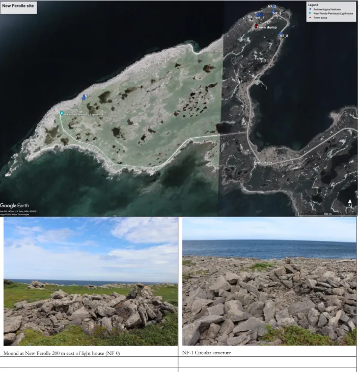
Our results give us confidence that Inuit do not have an archaeological presence on the northwest coast of Newfoundland and probably did not obtain caribou from this region by physically hunting these animals, although they did obtain animals indirectly through trade with Basque or French . It would be useful to test the Port-au-Chaix Northern Harbor pit house to see if it is an Inuit structure, as Selma Barkham (198:18) reported that this region was known for Inuit-Basque/French 'silent trade'. Old Ferolle North 'bakery' structure next to a modern cemetery, north to top right (photo: SBA).
Provincial Archaeology Office 2022 Journal Manuscript
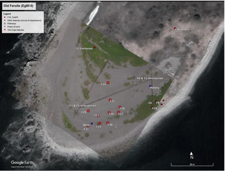
On the Question of the Tent Rings, Caribou, and Inuit in Northwest Newfoundland
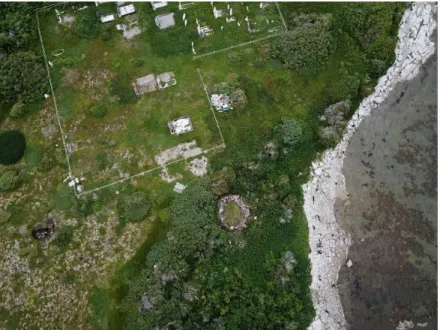
We located the tent rings at Ou Ferolle-Suid (EgBf-5) using a topographical map produced by Callum Thomson (1995). On the east side of the island we found several oblong stone mounds that could be part of this cemetery. South end of Old Ferolle Island (EgBf-5) and the location of the fish dry flakes and the tent rings found on the flake surface.
At the conclusion of our work of Old Ferolle, we spent several hours clearing encroaching vegetation from the site of the French oven (BgEf-4) on the northern end of the island. The stratigraphic position of the canopy ring features is later than the natural surface flake packing, indicating their placement in a specific area with less human traffic. Our limited understanding of the natural and/or anthropogenic packaging of surface flakes, and the layout of the fishing station and traffic areas, makes it difficult to ascertain whether canopy rings are contemporaneous with or post-station.
The group of nine rings within the boundaries of the flake drying surface at the fishing station on Ou Ferolle argues for an association between the unidentified tent dwellers and the French or Basque fishermen. Our work at the Old Ferolle Island (EgBf-5) fishing station did not provide definitive answers to the question of the tent ring dwellers' cultural affiliation, but established that they were occupied after the creation of the paved paths and the gravel-paved fish dry flakes on which the tent rings are found, and that the occupants had access to European materials. Consultation of previous archaeological reports and the assistance of the PAO revealed four sites with tent ring components on the northwest coast of Newfoundland.

Archaeological Surveys in the Strait of Belle Isle, in Archeology in Newfoundland and Labrador 1982, edited by Jane Sproull Thomson and Callum Thomson. Riding the Harp Seal Highway: Climate Modeling, Sea Ice Pulses, and Inuit Migrations in the Eastern Subarctic. In Animal Crashes: People and Animals in the Changing North, edited by Igor Krupnik and Aron Crowell, p.
Final Report Prepared for the Department of Tourism, Culture and Recreation, Government of Newfoundland and Labrador, St. View of the ancient cemetery and the Old Ferolle 'bakery' site (EgBf-4) (photo: Saraí Barreiro-Argüelles).
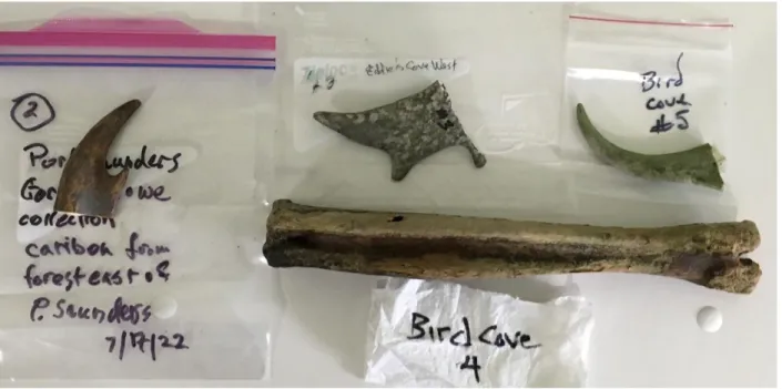
Newfoundland Artifact Finds (by Saraí Barrieiro-Argüelles)
Saraí Barriero-Argüelles and Francisco Rivera Amaro excavate Bonne Espérance-4 during the last day of excavation.
Ministry of Energy and Natural Resources (MERN) and Ministry of Culture and Communication (MCC) Permits
Dinner upon arrival in Quebec at Florence Hart's home in Brador: Florence, Perry, Francisco Rivera Amaro and Saraí Barreiro-Argüelles. right).
Project Description
He is part Inuit, a Rumbolt, and—he was proud to tell us—the owner of the shop. Garland advised us to hide our gas in the boat to avoid it being stolen, as happened recently due to the $2.45/gallon price at the pump. By the end of the day, I was beginning to think we might need St.
Start with the 15S-0W trench over the stone wall and burnt and broken tiles on the upper level east of the wall. At the end of the day I was concerned about getting back into the boat safely with our gear, but the team conveniently came on board. Perry spent much of the day among the baking apples near Salmon Bay Road and the city dump.
Test Pit 1 at the northern end of the site had a Basque layer under 20-30 cm of peat; Saraí records Test Pit 2 on the 'upper' terrace at the northern end of BE-4. Towards the end of the day I filled the 15S trough and the 9S/2W at the top of the mound. He has seen possible house depressions on one of the islands towards the sea, we should check out in the future.
Bonne Espérance-4 (EiBk-61) Field Report
North of the oval mound is the small depression where our 2019 test pit was located. Timber cut and worked from the waterlogged bottom of the 15S/0W depression between the wall and the hill ledge. This 2x2 m pit is adjacent to the northern side of the oval mound and is bordered on its eastern (uphill) side by a meter-high vertical rock ledge.
These materials were found in 10 to 12 different layers ranging from 1-15 cm thick from the top of the deposit to ca. Several long strips of baleen were found at the bottom of the pit, along with pieces of treated and untreated wood. Baleen materials were present from the top to the bottom of the pit and none appeared burned.
A 25 cm wide stack of several whale plates was just below the petticoat at the top of the pit. A 25 cm wide stack of seven whale slabs was found just below the ground in the upper part of the pit. Time did not permit the expansion or excavation of sterile soil.
Field Notes, Data, and Photographs
- Layer of blackish earth (7.5YR 3/1 very dark gray) with remains of coal and burnt stones, this layer is mixed with a large quantity of small fragments of tiles and presents some ash lenes with
- Sandy layer of grayish-beige color (10YR 5/2 Grayish brown) with some tile fragments
- Layer of fine texture reddish-brown color (10YR3/4 dusky red) with some gray and black color broken rocks and fragments of baleen and tile
- Light orange color layer (7.5YR Reddish yellow), fine texture with some small gray pebbles, baleen and fragments of crushed tile
- Grayish-beige color layer, similar to layer V (10YR 5/2 Grayish brown) and correlated with layer IX, this layer present in the upper part, a thin black layer of charcoal mixed with ash;
- Thin layer of light orange color (7.5YR Reddish yellow), similar to layer XVII, sandy texture, with small fragments of burned and crushed tile, a thickness of 2 cm to 6 cm
- Thin layer black color (7.5YR 3/1 very dark gray) similar to layer IV with gray color spots (ash) thickness of 4 cm to 2 cm
- Layer of fine orange soil (7.5YR Reddish yellow), the same texture as layer X with a thickness of 3 cm to 4 cm
15S/0-4W north wall profile showing the three-work center deposits to the west and cultural deposits in a depression on the east side of the wall. A small glazed ceramic fragment was in this clean sand near the bottom of the wall. Grass was limited to the top of the wall ridge, with other types of vegetation on the western slope.
In the experiments in the middle west of the wall, the culture stage starts 5 cm below the surface and continues to ca. At line 0W, the vertical shelf rises steeply to form a wall along the eastern side of the basin. The rock east of the wall probably fell from the top of the wall.
This unit is in the middle of the oval mound south of the bale pit. 8S3W: This unit is on the NW edge of the E-W oval mound in the center of the site. Map of Locus III unit on sloping bedrock 5m north of bale pit, showing location of artefacts found.
Provincial Archaeology Office Journal Manuscript
Excavations were carried out in four areas: a stone wall at the southern end of the site; a central mound composed of rocks and cinders; a 'baleen pit'. Time constraints limited our work to a few square meters in the test works and exploratory tests at the more open and flat northern end of the site. 150 meters from a sea cliff at the southern end of the site to a small inlet that terminates the level ground to the north.
The northern end of the bank has a 4-6 m wide, flat open area that rises gradually into the steeper hill slope. Four areas were selected for test excavations: a 1x4 E/W trench across the wall on the south side of the site; two 1x1 m units on the central mound; a 2x2 m unit in the slope tested in 2019; and one 1x1 m and two 50 cm test pits in the north. And in the likely general settlement area on the north side of the site, two 50 cm tests revealed a culture layer 10-15 cm thick under 30 cm of peat.
A striking feature of the archaeological finds was the large quantity of baleen, some of which came from large whales. None of the whalebones appear to have been burned, and their accidental removal indicates that the whalebones had no particular commercial value at the time. Paradise won, lost and regained: pulse migration and the Inuit archeology of Quebec's Lower North Shore.