Thursday 01 April 2021 MORNING Time of Issue: 0800 hours IST ALL INDIA WEATHER SUMMARY AND FORECAST BULLETIN
Significant Weather Features
♦ A Low Pressure Area lies over south Andaman Sea & neighbourhood. It is likely to become more marked over central parts of Andaman Sea & neighbourhood during next 12 hours and likely to concentrate into a Depression over the same region during subsequent 24 hours. Under its influence:
(i) Widespread to scattered rainfall very likely over Andaman & Nicobar Islands during next 5 days and isolated heavy falls on 01st April.
(ii) Isolated thunderstorm, lightning & gusty winds also likely over Andaman & Nicobar Islands during next 2 days.
(ii) Fishermen are advised not to venture into South Andaman Sea & adjoining Southeast Bay of Bengal on 01st April and into North Andaman Sea on 02nd April.
♦ Under the influence of strong lower level south-westerly winds from the Bay of Bengal and other favourable meteorological conditions, fairly widespread to widespread rainfall with isolated thunderstorm/lightning & gusty winds very likely over Northeast India during 01st-02nd April.
♦ Maximum temperatures have fallen by 2-4°C over most parts of Northwest and Central India leading to abatement of heat wave conditions from these regions.
♦ Strong Surface Winds (speed reaching 30-40 kmph) over parts of Punjab, Rajasthan, Haryana, Chandigarh & Delhi, Uttar Pradesh, Madhya Pradesh during next 24 hours.
Main Weather Observations
♦ Rain/Thundershowers observed (from 0830 hours IST to 1730 hours IST of yesterday): at most places over Arunachal Pradesh at a few places over Andaman & Nicobar Islands, Sub-Himalayan West Bengal & Sikkim and at isolated places over Assam & Meghalaya, Jammu, Kashmir, Ladakh, Gilgit, Baltistan & Muzaffarabad, Lakshadweep and Kerala & Mahe.
♦ Rainfall recorded (from 0830 hours IST to 1730 hours IST of yesterday (1 cm or more):Car Nicobar-2; Gangtok and Hut Bay -1 each.
♦ Thunderstorm observed (from 0830 hours IST to 0530 hours IST of today): at isolated places over Assam & Meghalaya and Tripura.
♦ Yesterday, Heat Wave Conditions to Severe Heat Wave Conditions observed in some pockets over Gangetic West Bengal, Odisha, Coastal Andhra Pradesh & Yanam and Tamilnadu, Puducherry & Karaikal.
♦ Maximum Temperature Departures as on 31-03-2021: Maximum temperatures were markedly above normal (5.1°C or more) at a few places over Gangetic West Bengal and Coastal Andhra Pradesh & Yanam and at isolated places over Odisha and Telangana; appreciably above normal (3.1°C to 5.0°C) at many places over Uttarakhand and West Uttar Pradesh; at a few places over Himachal Pradesh, Haryana, Chandigarh & Delhi, Saurashtra & Kutch, South Interior Karnataka and Rayalaseema; above normal (1.6°C to 3.0°C) at most places over Jammu, Kashmir, Ladakh, Gilgit, Baltistan & Muzaffarabad and North Interior Karnataka; at many places over Punjab, Rajasthan, Gujarat Region, Madhya Maharashtra, Marathawada, East Uttar Pradesh, Chhattisgarh, Madhya Pradesh and Vidarbha; at a few places over Coastal Karnataka and Tamil Nadu, Puducherry & Karaikal. They were markedly below normal (-5.1°C or less) at a few places over Arunachal Pradesh; appreciably below normal (-3.1°C to -5.0°C) at a few places over Bihar and Sub-Himalayan West Bengal
& Sikkim and Nagaland, Manipur, Mizoram & Tripura and below normal (-1.6°C to -3.0°C) at many places over Andaman& Nicobar Islands and at a few places over Bihar and near normal over rest parts of the country. Yesterday, the highest maximum temperature of 44.2°C was reported at Bhubaneshwar (Odisha) over the country.
♦ Minimum Temperature Departures as on 31-03-2021: Minimum temperatures were markedly above normal (5.1°C or more) at a few places over West Rajasthan, Madhya Pradesh, Chhattisgarh and Jharkhand; appreciably above normal (3.1°C to 5.0°C) at most places over East Uttar Pradesh; at many places Haryana, Chandigarh & Delhi, West Uttar Pradesh and Gujarat state; at a few places over East Rajasthan, Odisha, Bihar, Gangetic West Bengal; at isolated places over Himachal Pradesh; above normal (1.6°C to 3.0°C) at many places over Coastal Karnataka, Coastal Andhra Pradesh & Yanam and Sub-Himalayan West Bengal & Sikkim; at a few places over Lakshadweep, South Interior Karnataka, Kerala & Mahe, Tamil Nadu, Puducherry & Karaikal, Rayalseema, Andaman & Nicobar Islands and Jammu, Kashmir, Ladakh, Gilgit, Baltistan & Muzaffarabad. They were below normal (-1.6°C to -3.0°C) at a few places over Madhya Maharashtra and at isolated places over Telangana and near normal over rest parts of the country. Yesterday, the lowest minimum temperature of 12.0°C was reported at Una (Himachal Pradesh) over the plains of the country.
* Red color warning does not mean "Red Alert" Red color warning means "Take Action".
Forecast and Warning for any day is valid from 0830 hours IST of day till 0830 hours IST of next day For more details kindly visit www.imd.gov.in or contact : +91 11 24631913, 24643965, 24629798
(Service to the Nation since 1875)
Meteorological Analysis (Based on 0530 hours IST)
♦ The Low Pressure Area over south Andaman Sea & adjoining Southeast Bay of Bengal now lies over south Andaman Sea
& neighbourhood. The associated cyclonic circulation extends upto 5.8 km above mean sea level. It is likely to become more marked over Central parts of Andaman Sea & neighbourhood during next 12 hours and likely to concentrate into a Depression over the same region during subsequent 24 hours.
♦ The cyclonic circulation over central Pakistan & neighbourhood extending upto 1.5 km above mean sea level persists.
♦ The Western Disturbance as a trough now runs roughly along Long. 75°E to the north of Lat. 32°N between 3.1 & 3.6 km above mean sea level persists.
♦ The north-south trough from Jharkhand to north Coastal Andhra Pradesh extending upto 1.5 km above mean sea level persists.
♦ The north-south trough from North Interior Karnataka to south Kerala extending upto 0.9 km above mean sea level persists.
♦ The trough roughly along Long. 88°E to the north of Lat. 23°N at 2.1 km above mean sea level persists.
♦ The east-west trough at mean sea level from East Uttar Pradesh to west Assam persists.
♦ A fresh feeble Western Disturbance is likely to affect Western Himalayan Region from today, 01st April.
♦ Another fresh Western Disturbance is likely to affect Western Himalayan Region from the night of 03rd April.
♦ The cyclonic circulation over southeast Arabian Sea & adjoining Equatorial Indian Ocean extending upto 1.5 km above mean sea level has become less marked.
Weather Forecast for next 5 days * upto 0830 hours IST of 06th April, 2021
♦ Meteorological sub-division wise detailed 5 days precipitation forecast is given in Table-1.
♦ No significant change in maximum temperatures over most parts of Northwest and Central India during next 2 days and rise by 2-4°C thereafter.
♦ Fall in maximum temperatures by 2-3°C over most parts of East India during next 48 hours.
♦ No significant change in maximum temperatures over rest parts of the country during next 5 days.
Weather Outlook for subsequent 2 days from 06th April, 2021 to 08th April, 2021
♦ Fairly widespread light to moderate rainfall/snowfall with thunderstorm/lightning likely over Jammu & Kashmir, Ladakh, Gilgit-Baltistan & Muzaffarabad, Himachal Pradesh and Uttarakhand .
♦ Isolated rainfall with thunderstorm/lightning likely over Punjab, Haryana, Chandigarh & Delhi, West Uttar Pradesh, Kerala, Arunachal Pradesh, Assam & Meghalaya, Nagaland, Manipur and Andaman & Nicobar Islands.
♦ Dry weather likely over rest parts of the country.
* Red color warning does not mean "Red Alert" Red color warning means "Take Action".
Weather Warning during next 5 days *
01 April (Day 1):♦ Thunderstorm with lightning & squall (speed reaching 50-60 kmph) very likely at isolated places over Andaman
& Nicobar Islands; with lightning & squall (speed reaching 45-55 kmph) at isolated places over Sub-Himalayan West Bengal & Sikkim;
with lightning and gusty winds (speed reaching 30-40 kmph) at isolated places over Arunachal Pradesh and Assam & Meghalaya and with lightning at isolated places over Kerala & Mahe.
♦ Heavy rainfall very likely at isolated places over Andaman & Nicobar Islands.
♦ Heat Wave Conditions in some pockets with Severe Heat Wave Conditions in isolated pockets very likely over Odisha and Heat Wave Conditions in isolated pockets over Coastal Andhra Pradesh & Yanam and Tamilnadu, Puducherry & Karaikal.
♦ Squally weather (wind speed reaching 40-50 kmph gusting to 60 kmph) very likely over south Andaman Sea & adjoining Southeast Bay of Bengal. Fishermen are advised not to venture into these areas. Strong winds (speed reaching 40-50 kmph) over Westcentral Bay of Bengal, along & off Andhra Pradesh coast and Gulf of Mannar, along & off Tamil Nadu coast.
02 April (Day 2):♦ Thunderstorm with lightning & gusty winds (speed reaching 30-40 kmph) very likely at isolated places over Sub- Himalayan West Bengal & Sikkim, Andaman & Nicobar Islands, Odisha and with lightning at isolated places over Kerala & Mahe.
♦ Heat Wave Conditions very likely in isolated pockets over Coastal Andhra Pradesh & Yanam, Tamilnadu, Puducherry & Karaikal and Saurashtra & Kutch.
♦ Squally weather (wind speed reaching 45-55 kmph gusting to 65 kmph) very likely over north Andaman Sea. Fishermen are advised not to venture into these areas. Strong winds (speed reaching 40-50 kmph) over Westcentral Bay of Bengal, along & off Andhra Pradesh coast, Gulf of Mannar, along & off Tamil Nadu coast and Comorin area.
03 April (Day 3): ♦ Thunderstorm with lightning & gusty winds (speed reaching 30-40 kmph) very likely at isolated places over Gangetic West Bengal and Odisha and with lightning at isolated places over Kerala & Mahe.
♦ Heat Wave Conditions very likely in isolated pockets over Tamilnadu, Puducherry & Karaikal and Saurashtra & Kutch.
04 April (Day 4):♦ Thunderstorm with lightning & gusty winds (speed reaching 30-40 kmph) very likely at isolated places over Gangetic West Bengal and with lightning at isolated places over Jammu & Kashmir, Ladakh, Gilgit-Baltistan & Muzaffarabad and Kerala
& Mahe.
♦ Heat Wave Conditions very likely in isolated pockets over Tamilnadu, Puducherry & Karaikal.
05 April (Day 5): ♦ Thunderstorm with lightning & gusty winds (speed reaching 30-40 kmph) very likely at isolated places over Gangetic West Bengal and with lightning at isolated places over Jammu & Kashmir, Ladakh, Gilgit-Baltistan & Muzaffarabad, Himachal Pradesh, Uttarakhand, Punjab, Haryana, Chandigarh & Delhi and Kerala & Mahe.
♦ Heat Wave Conditions very likely in isolated pockets over Tamilnadu, Puducherry & Karaikal.
Kindly download MAUSAM APP for location specific forecast & warning, MEGHDOOT APP for Agromet advisory and DAMINI APP for Lightning Warning & visit state MC/RMC websites for district wise warning.
* Red color warning does not mean "Red Alert" Red color warning means "Take Action".
Forecast and Warning for any day is valid from 0830 hours IST of day till 0830 hours IST of next day For more details kindly visit www.imd.gov.in or contact : +91 11 24631913, 24643965, 24629798
(Service to the Nation since 1875)
Table-1
* Red color warning does not mean "Red Alert" Red color warning means "Take Action".
ALL INDIA WEEKLY WEATHER REPORT 25 MARCH – 31 MARCH, 2021
Table-1(A) Table-1(B) Table-1(C) Table-2 Table-3 Fig-1 Fig-2 Annexure-1
SIGNIFICANT WEATHER FEATURES
♦ Movement of two to three Western Disturbances have caused scattered to fairly widespread rainfall/thunderstorm activity over Jammu Kashmir & Ladakh and isolated to scattered rainfall/thunderstorm activity over remaining parts of Western Himalayan Region during the week.
♦ Remnants of Western Disturbances and presence of trough in low level westerlies /cyclonic circulation in the lower levels supported by strong southwesterlies from the Bay of Bengal causing moisture incursion over the area have caused fairly widespread to widespread rainfall/thunderstorm activity over Northeast and adjoining areas of East India during the second half of the week.
♦ Trough/wind discontinuities in the lower levels have caused isolated to scattered rainfall/thunderstorm activity over South Peninsula during the week; it has also caused fairly widespread rainfall/thunderstom activity along with isolated heavy rainfall over Kerala & Mahe on one day during the week.
♦ A cyclonic circulation extending upto mid tropospheric levels lay over Southeast Bay of Bengal & adjoining South Andaman Sea on 29
thMarch 2021 and it persisted over the same area on 30
th; Under its influence, a Low Pressure Area has formed over Southeast Bay of Bengal & adjoining South Andaman Sea in the early morning hours of 31
stwhich lay over South Andaman Sea and adjoining Southeast Bay of Bengal by the evening of the same day; this system has caused scattered to fairly widespread rainfall/thunderstorm activity over Andaman & Nicobar islands during the second half of the week.
♦ A cyclonic circulation extending upto 5.8 km above mean sea level lay over Equatorial Indian Ocean &
adjoining Southeast Arabian Sea on 29
thMarch 2021; Under its influence, a Low Pressure Area has formed over Equatorial Indian Ocean and adjoining areas, to the south of Southeast Arabian Sea in the evening of the same day; it lay over Southeast Arabian Sea & adjoining Equatorial Indian Ocean on 30
thMarch 2021;this system has become less marked on 31
stMarch 2021; this system has not caused any significant weather over Indian coast, since it had been away from the coast.
Heavy Rain:
♦ Heavy rainfall had occurred at isolated places over Kerala & Mahe on one day during the week.
Temperature Scenario:
♦ Heat wave to Severe heatwave conditions had occurred at some parts over Saurashtra & Kutch, Coastal Andhra Pradesh & Yanam , Tamil Nadu, Puducherry & Karaikkal , Gangetic West Bengal and Odisha, on one day each; at isolated places over Saurashtra & Kutch and Konkan & Goa on one day each during the week.
♦ Heatwave conditions at most places with Severe Heatwave conditions at isolated places had occurred over West Rajasthan on two days during the week.
♦ Heatwave conditions at a few places with Severe heat wave conditions at isolated places had occurred over West Rajasthan and Konkan & Goa on one day each during the week.
♦ Heat conditions at many places had occurred over Saurashtra & Kutch on one day; at a few places over Saurashtra & Kutch on one day; at isolated places over Himachal Pradesh and East Rajasthan on two days each and over Konkan & Goa, Gujarat Region, Madhya Pradesh, West Uttar Pradesh, Jharkhand, Vidarbha, Odisha and Gangetic West Bengal on one day each during the week.
♦ The highest maximum temperature of 44.6
oC had been recorded at Baripada (Odisha) on 30
thMarch 2021 and the lowest minimum temperature of 10.3
oC had been recorded at Pantnagar (Uttarakhand) on 26
thMarch 2021 over the plains of the country during the week.
LEGEND: A few days- 3 days, Many days- 4 to 5 days and Most days- 6 to 7 days during the week.
METEOROLOGICAL ANALYSIS
♦ Remnants of last week’s Western Disturbance was seen as a trough in mid tropospheric westerlies with its axis at 5.8 km above mean sea level roughly along Long 86°E to the north of Lat 24°N on 25
thMarch 2021; it continued to be seen as a trough in mid tropospheric westerlies with its axis at 5.8 km above mean sea level roughly along Long 88°E to the north of Lat 25°N on 26
th; it has become less marked on 27
thMarch 2021.
♦ Last week’s trough in westerlies at 0.9 km above mean sea level roughly along Long 88°E to the north of Lat 22°N has become less marked on 25
thMarch 2021.
♦ Last week’s induced cyclonic circulation over South Haryana & neighbourhood extending upto at 1.5 km above mean sea level has become less marked on 25
thMarch 2021.
Government of India
Ministry of Earth Sciences
India Meteorological Department
National Weather Forecasting Centre
♦ Last week’s cyclonic circulation over Madhya Maharashtra & neighbourhood extending upto 1.5 km above mean sea level has become less marked on 25
thMarch 2021.
♦ Last week’s cyclonic circulation over southeast Madhya Pradesh & neighbourhood extending between 1.5 km & 2.1 km above mean sea level has become less marked on 25
thMarch 2021.
♦ A wind discontinuity at 0.9 km above mean sea level ran from Rayalaseema to south Odisha across Coatsal Andhra Pradesh on 25
thMarch 2021; it ran from Telangana to south Odisha across south Chhattisgarh on 26
th; it has become less marked on 27
thMarch 2021.
♦ A Western Disturbance as a cyclonic circulation lay over north Pakistan & adjoining Jammu & Kashmir between 2.1 & 3.6 km above mean sea level on 27
thMarch 2021; it has moved away east-northeastwards on 28
thMarch 2021.
♦ A cyclonic circulation lay over Central Pakistan & adjoining West Rajasthan and extended up to 0.9 km above mean sea level on 27
thMarch 2021; it lay over East Rajasthan & neighbourhood and extended upto 0.9 km above mean sea level on 28
th; it has become less marked on 29
thMarch 2021.
♦ A trough in easterlies extending upto 0.9 km above mean sea level ran from Maldives area to Coastal Karnataka across Kerala on 27
thMarch 2021; it has become less marked on 28
thMarch 2021.
♦ A cyclonic circulation lay over south Chhattisgarh and neighbourhood and extended up to 1.5 km above mean sea level on 27
thMarch 2021; it has become less marked on 28
thMarch 2021.
♦ A Western Disturbance as a cyclonic circulation lay over Afghanistan at 3.1 km above mean sea level on 28
thMarch 2021; it lay as a cyclonic circulation over north Pakistan & neighbourhood and seen between 3.1 & 3.6 km above mean sea level on 29
th; it has become less marked on 30
thMarch 2021.
♦ A trough in mid and upper tropospheric westerlies with its axis at 5.8 km above mean sea level ran roughly along Long 86°E to the north of Lat. 20°N on 28
thMarch 2021; it ran roughly along Long. 90°E to the north of Lat. 22°N on 29
thand it persisted like that on 30
th; it has become less marked on 31
stMarch 2021.
♦ A cyclonic circulation lay over Madhya Maharashtra & neighbourhood and extended upto 1.5 km above mean sea level on 28
thMarch 2021; it lay over south Maharashtra & neighbourhood and extended upto 0.9 km above mean sea level on 29
th; it has become less marked on 30
thMarch 2021.
♦ A cyclonic circulation lay over Southeast Bay of Bengal & neighbourhood and extended upto 4.5 km above mean sea level on 29
thMarch 2021; it lay over Southeast Bay of Bengal & adjoining South Andaman Sea and extended upto 4.5 km above mean sea level on 30
th; Under its influence, a Low Pressure Area has formed over Southeast Bay of Bengal & adjoining south Andaman Sea in the early morning hours of 31
st;it persisted over the same area with the associated cyclonic circulation extending upto 5.8 km above mean sea level till afternoon of 31
st; it lay over South Andaman Sea and adjoining Southeast bay of Bengal with the associated cyclonic circulation extending upto 5.8 km above mean sea level in the evening of 31
stMarch 2021.
♦ A cyclonic circulation extending upto 5.8 km above mean sea level lay over Equatorial Indian Ocean &
adjoining Southeast Arabian Sea on 29
thMarch 2021; Under its influence, a Low Pressure Area has formed over Equatorial Indian Ocean to the south of Southeast Arabian Sea in the evening of the same day with the associated cyclonic circulation extending upto mid tropospheric levels; it lay over Southeast Arabian Sea &
adjoining Equatorial Indian Ocean with the associated cyclonic circulation extending upto 3.1 km above mean sea level on 30
th; The Low pressure area has become less marked however the associated cyclonic circulation lay over Southeast Arabian Sea & adjoining Equatorial Indian Ocean and extended upto 1.5 km above mean sea level on 31
stMarch 2021.
♦ A cyclonic circulation lay over Central Pakistan & neighbourhood and extended upto 0.9 km above mean sea level on 29
thMarch 2021; it persisted over the same area and extended upto 1.5 km above mean sea level on 30
thand 31
stMarch 2021.
♦ A cyclonic circulation lay over West Assam & neighbourhood between1.5 km & 2.1 km above mean sea level on 30
thMarch 2021; it has become less marked on 31
stMarch 2021.
♦ A Western Disturbance as a trough in mid tropospheric westerlies ran roughly along Long. 72°E to the north of Lat. 32°N between 3.1 & 3.6 km above mean sea level on 31
stMarch 2021.
♦ A north-south trough extending upto 1.5 km above mean sea level ran from Jharkhand to north Coastal Andhra Pradesh on 31
stMarch 2021.
♦ Another north-south trough ran from North Interior Karnataka to south Kerala and extended upto 0.9 km above mean sea level on 31
stMarch 2021.
♦ A trough at 2.1 km above mean sea level ran roughly along Long. 88°E to the north of Lat. 23°N on 31
stMarch 2021.
♦ An east-west trough at mean sea level lay extending from East Uttar Pradesh to west Assam on 31
stMarch
2021.
RAINFALL SUMMARY Category of the rainfall
WEEK SEASON
25.03.2021 TO 31.03.2021 01.03.2021 TO 31.03.2021 Number of Sub-divisions Number of Sub-divisions
LARGE EXCESS (+60% or more) 4 3
EXCESS (+20% to +59%) 0 2
NORMAL (+19% to -19%) 0 5
DEFICIENT (-20% to -59%) 5 6
LARGE DEFICIENT (-60% to -99%) 13 17
NO RAIN (-100%) 14 3
Cumulative rainfall (mm) Actual Normal % Departure Actual Normal % Departure
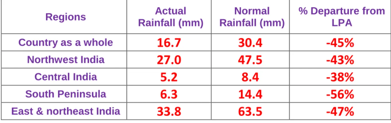
EAST & NORTH-EAST INDIA 9.9 20.2 -51% 33.8 63.5 -47%
NORTH-WEST INDIA 2.7 9.2 -70% 27.0 47.5 -43%
CENTRAL INDIA 0.2 1.9 -92% 5.2 8.4 -38%
SOUTH PENINSULA 2.7 3.5 -22% 6.3 14.4 -56%
country as a whole 3.0 7.4 -59% 16.7 30.4 -45%
• Sub-division wise weekly and seasonal rainfall distribution is presented in Fig-1 and Fig-2.
• Sub-divisionwise daily distribution of realised Rainfall is shown in Table-1(A).
• Sub-divisionwise departure of realised Maximum temperature from Normal is shown in Table-1(C)
• Statewise distribution of number of districts with Large-Excesse, Excess, Normal, Deficient, Large-deficient and no rainfall is shown in Table-2.
• Cumulative seasonal rainfall data during the corresponding weekly period for the last five years are given in Table-3.
• Sub-divisionwise realised weekly rainfall (in cm) is shown in Annexure-1.
FORECAST & WARNING FOR THE NEXT WEEK 01 April TO 07 April, 2021
Detailed seven days Sub-division wise rainfall-forecast & weather-warning is given in Table-1(B) .
Back to Top
Table-1 (A)
METEOROLOGICAL SUB-DIVISIONWISE DISTRIBUTION OF REALISED RAINFALL-2021
S.No. MET.SUB-DIVISIONS 25 MAR 26 MAR 27 MAR 28 MAR 29 MAR 30 MAR 31 MAR
1 ANDAMAN & NICO.ISLANDS SCT D SCT SCT SCT SCT FWS
2 ARUNACHAL PRADESH FWS ISOL D D D FWS WS
3 ASSAM & MEGHALAYA ISOL D D D D WS WS
4 NAGA.MANI.MIZO.& TRIPURA D D D D D FWS WS
5 SUB-HIM.W. BENG. & SIKKIM SCT ISOL D D ISOL SCT FWS
6 GANGETIC WEST BENGAL D D D D D D D
7 ODISHA ISOL D D ISOL ISOL D D
8 JHARKHAND D D D ISOL D D D
9 BIHAR D D D D D D D
10 EAST UTTAR PRADESH D D D D D D D
11 WEST UTTAR PRADESH D D D D D D D
12 UTTARAKHAND ISOL D D ISOL ISOL D D
13 HARYANA CHD. & DELHI D D D D D D D
14 PUNJAB D D D D D D D
15 HIMACHAL PRADESH SCT ISOL D D ISOL ISOL D
16
JAMMU & KASHMIRANDLADAKHFWS D D ISOL SCT FWS SCT
17 WEST RAJASTHAN D D D D D D D
18 EAST RAJASTHAN D D D D D D D
19 WEST MADHYA PRADESH ISOL D D D D D D
20 EAST MADHYA PRADESH ISOL D D D D D D
21 GUJARAT REGION D D D D D D D
22 SAURASTRA & KUTCH D D D D D D D
23 KONKAN & GOA ISOL ISOL D D D D D
24 MADHYA MAHARASHTRA ISOL D D D D D D
25 MARATHAWADA D D D D D D D
26 VIDARBHA ISOL D D D D D D
27 CHHATTISGARH D D D D D D D
28 COASTAL ANDHRA PR. & YANAM D ISOL ISOL ISOL D D D
29 TELANGANA D D ISOL ISOL D D D
30 RAYALASEEMA D D D D D D D
31 TAMIL. PUDU. & KARAIKAL D ISOL ISOL ISOL ISOL ISOL D
32 COASTAL KARNATAKA SCT ISOL D ISOL SCT FWS D
33 NORTH INT.KARNATAKA ISOL D ISOL ISOL ISOL ISOL D
34 SOUTH INT.KARNATAKA D ISOL D ISOL ISOL ISOL D
35 KERALA & MAHE ISOL SCT ISOL SCT SCT FWS ISOL
36 LAKSHADWEEP SCT SCT D FWS D D D
LEGENDS:
WS -
WIDE SPREAD / MOST PLACES (76-100%)FWS -
FAIRLY WIDE SPREAD / MANY PLACES (51% to 75%)SCT -
SCATTERED / FEW PLACES (26% to 50%)ISOL -
ISOLATED (up to 25%) D / DRY - NO STATION REPORTED RAINFALL*
ACTIVE (R/F 11/2- 4 times the normal with WS/FWS, at least 2 stations should be 5 cm. along west coast & 3 cm. elsewhere )**
VIGOROUS (R/F More than 4 times the normal with WS/FWS, at least 2 stations should be 8 cm. along west coast & 5 cm. elsewhere)Back to Top
Table-1 (B)
METEOROLOGICAL SUB-DIVISIONWISE WEEKLY RAINFALL FORECAST & Wx. WARNINGS-2021
Sr. No MET.SUB-DIVISIONS 01 APR 02 APR 03 APR 04 APR 05 APR 06 APR 07 APR
1 ANDAMAN & NICO.ISLANDS WS
● $FWS
LISOL ISOL ISOL ISOL ISOL
2 ARUNACHAL PRADESH WS
● LFWS
LFWS SCT
ISOL ISOL SCT
3 ASSAM & MEGHALAYA FWS
$SCT
LSCT
SCT
LISOL ISOL SCT
4 NAGA.MANI.MIZO.& TRIPURA FWS
LSCT
ISOL SCT
LSCT
ISOL ISOL 5 SUB-HIM.W. BENG. & SIKKIM FWS
LISOL
LISOL D D ISOL SCT
6 GANGETIC WEST BENGAL D
ISOL ISOL
LSCT
LD
D D
7 ODISHA D
+ISOL
LISOL
LISOL
LISOL
LISOL D
8 JHARKHAND D D D D D D D
9 BIHAR D D D D D D D
10 EAST UTTAR PRADESH D D D D D D D
11 WEST UTTAR PRADESH D D D D D D D
12 UTTARAKHAND D D D ISOL
SCT
L #FWS FWS
13 HARYANA CHD. & DELHI D D D D ISOL ISOL D
14 PUNJAB D D D D ISOL ISOL D
15 HIMACHAL PRADESH D D D ISOL FWS
L #WS FWS
16
JAMMU & KASHMIRANDLADAKHISOL ISOL D SCT
L #WS
L #WS SCT
17 WEST RAJASTSAN D D D
D
D D D
18 EAST RAJASTSAN D D D
D
D D D
19 WEST MADHYA PRADESH D D D D D D D
20 EAST MADHYA PRADESH D D D D D D D
21 GUJARAT REGION D
D
D D D D D
22 SAURASTRA & KUTCH D
D
D
D D D D
23 KONKAN & GOA D D D D D D D
24 MADHYA MAHARASHTRA D D D D D D D
25 MARATHAWADA D D D D D D D
26 VIDARBHA D D D D
D
D D
27 CHHATTISGARH D D D D D D D
28 COASTAL ANDHRA PR. & YANAM D
+D
+ISOL
LISOL
LISOL
LISOL D
29 TELANGANA D
D
D D D D D
30 RAYALASEEMA D D
D D D D D
31 TAMIL. PUDU. & KARAIKAL D
D
D
ISOL
LISOL
LISOL ISOL
32 COASTAL KARNATAKA D D D D D D D
33 NORTH INTERIOR KARNATAKA D D D D D D D
34 SOUTH INTERIOR KARNATAKA D D D D D D D
35 KERALA & MAHE
SCT
LISOL
LISOL
LISOL
LISOL
LISOL SCT
36 LAKSHADWEEP SCT D D D D D D
LEGENDS:
WS -
WIDE SPREAD / MOST PLACES (76-100%)FWS -
FAIRLY WIDE SPREAD / MANY PLACES (51% to 75%)SCT -
SCATTERED / FEW PLACES (26% to 50%)ISOL -
ISOLATED (up to 25%)D / DRY -
NO RAINFALL●Heavy Rainfall (64.5-115.5 mm) ●●Heavy to Very Heavy Rainfall (115.6-204.4 mm) ●●●Extremely Heavy Rainfall (204.5 mm or more)
F
Fog *
Snowfall DDuststorm $Thunderstorm with Squall L Thunderstorm with Lightning # Thunderstorm with Hail Cold Wave (Minimum temperature departure from Normal -4.5 OC to -6.4OC)
- -Severe Cold Wave (Minimum temperature departure from Norma ≤ -6.5OC) Heat Wave (Maximum temperature departure from Normal +4.5 OC to +6.4OC)
+ Severe Heat Wave (Maximum temperature departure from Normal ≥ +6.5OC)Back to Top
Table-1 (C)
METEOROLOGICAL SUB-DIVISIONWISE REALISED MAXIMUM TEMPERATURE-2021
S.No MET.SUB-DIVISIONS 25 MAR 26 MAR 27 MAR 28 MAR 29 MAR 30 MAR 31 MAR
1 ANDAMAN & NICO.ISLANDS N N N N N N BN
2 ARUNACHAL PRADESH AAN N N N N ABN N
3 ASSAM & MEGHALAYA N N MAN N N ABN N
4 NAGA.MANI.MIZO.& TRIPURA AAN N AN AN N N N
5 SUB-HIM.W. BENG. & SIKKIM AN AN AN N N N N
6 GANGETIC WEST BENGAL N N AN N N MAN N
7 ODISHA N AN N AN AAN N N
8 JHARKHAND AN AN N AN AAN MAN N
9 BIHAR N N N N N N N
10 EAST UTTAR PRADESH N N N N AAN MAN AN
11 WEST UTTAR PRADESH N N N AN N MAN AAN
12 UTTARAKHAND AN N AAN N N MAN AAN
13 HARYANA, CHD. & DELHI N N N N MAN AAN N
14 PUNJAB N N N AAN AAN N AN
15 HIMACHAL PRADESH N N N N N MAN N
16
JAMMU & KASHMIRANDLADAKHN N AAN N N N AN
17 WEST RAJASTHAN N AAN AAN MAN MAN N AN
18 EAST RAJASTHAN N N AAN N MAN AAN AN
19 WEST MADHYA PRADESH N N N N N N AN
20 EAST MADHYA PRADESH N N N N N N AN
21 GUJARAT REGION N N N N AN N AN
22 SAURASTRA & KUTCH N N N N N N N
23 KONKAN & GOA N N N N N N N
24 MADHYA MAHARASHTRA N N N N AN N AN
25 MARATHAWADA N N N AN AN AN AN
26 VIDARBHA N N N AN AAN AAN AN
27 CHHATTISGARH N N N AN AN AAN AN
28 COASTAL ANDHRA PR. & YANAM N AN N N N N N
29 TELANGANA N N N N N N N
30 RAYALASEEMA N N N N N N N
31 TAMIL. PUDU. & KARAIKAL N N N N N N N
32 COASTAL KARNATAKA AN N AN N AN AN N
33 NORTH INTERIOR KARNATAKA N N N N N N AN
34 SOUTH INTERIOR KARNATAKA N N N N N N N
35 KERALA & MAHE N N N N N N N
36 LAKSHADWEEP N N N N N N N
Highest Maximum Temperature (°C) 40.4 40.8 42.1 42.8 43.3 44.6 44.2
Station(/s) observed HMT
Porbandar Rudramata Bhuj- Sundernagar Barmer Brahmapuri Churu/ Baripada BhubaneswarStation(/s) lies in Met-Subdivision(/s)
Sau. &Kutch Sau. & Kutch Sau. & Kutch West Raj. West Raj/
Vidarbha Odisha Odisha
Lowest Minimum Temperature (°C) 13.0 10.3 11.4 14.0 14.6 15.0 12.0
Station/(s) observed LMT
Sikar Pant Nagar Pant Nagar Bulsar Raisen Pant Nagar UnaStation/(s) lies in Met-Subdivision/(s)
East Raj. Uttarakhand Uttarakhand Guj.Region West M.P. Uttarakhand Himachal Pradesh