세부사업명 한반도 해역 고해상도 재분석자료 제작 및 활용 한반도 해역 고해상도 재분석자료 생산 및 활용 한반도 해역 고해상도 재분석자료 제작 및 검증
재분석자료 검증을 위한 제주해협 표층해류 모니터링 재분석 데이터를 기반으로 한 고온 저염 현상의 구조 및 영향 평가. 재분석 데이터 기반 생태계 모델 적용 및 활용
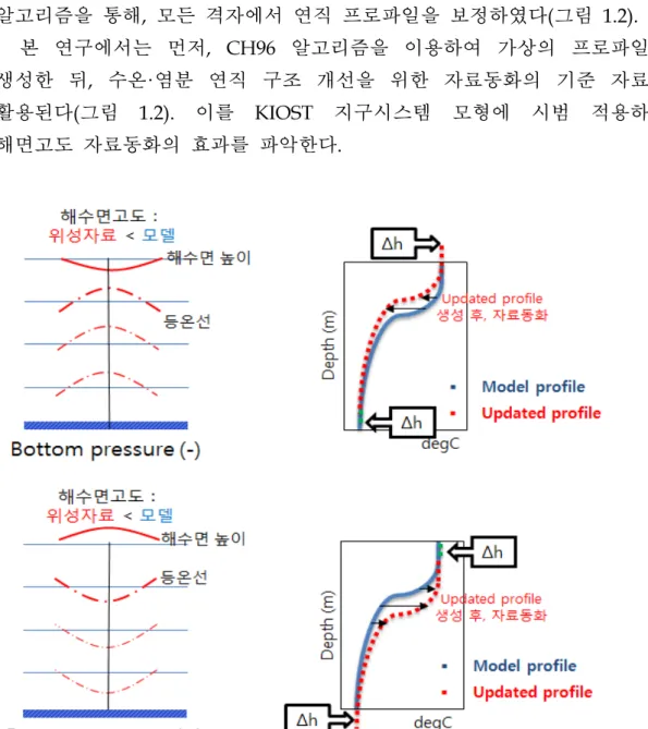
한반도 해역 고해상도 재분석자료 생산 및 활용 한반도 고해상도 재분석자료 생산 및 검증 ○ 해수면 자료동화체계 구축
연구개발결과의 활용계획
주성분(PC1)은 북태평양 서부(필리핀해)의 해수면 온도 온난화와 강한 상관관계를 나타냅니다. 우리나라 적조생물(HABs)의 장기변이와 양쯔강 희석수의 관계. 국내에서 발생하는 코클로디늄 적조(HAB) 장기관측자료 결과에 관하여.
한국 연안 해역의 산호 분포 변화 특성. 우리나라 지역별 어획량의 특징. 우리나라 주변 해역의 고수온 발생 예측 기반 마련
과거 우리나라 유해조류 발생현황 자료를 재해석하여 향후 적조피해 최소화를 위한 관리방안을 제시하기 위한 기준자료로 활용한다. 한반도 주변 해역의 해양생물자원 미래변화 예측 등
Title
Necessities and Objectives of Research and Development
Contents of Research and Development
Evaluating the structure and effect of high temperature and low salinity events based on reanalysis data. Correlation between saline and seawater CDOM in the Yellow Sea region based on in situ data. Relationship between long-term trends of red tide organism (HAB) and the expansion of Yangtze dilute water in Korean water.
Distribution Characteristics of soft coral in Korean waters ○ Long-term catch trends of commercial fish.
Results
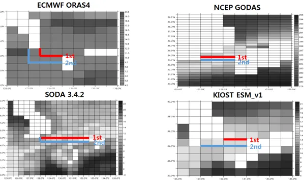
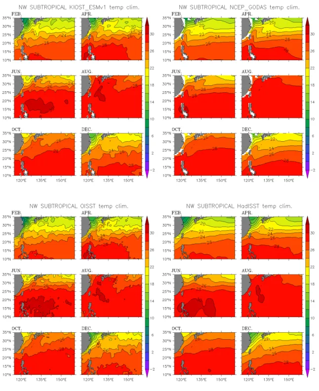
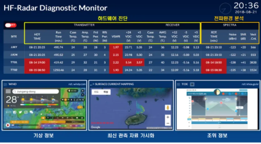
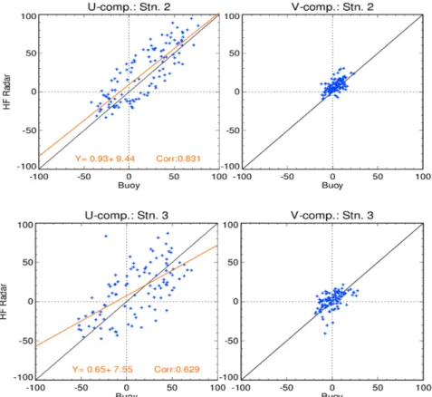
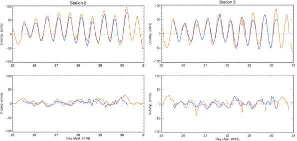
Comparison of reanalysis data with observations of the distribution of warm eddies in the western subtropical North Pacific. Sea surface temperature (SST) in KIOST ESM_v1 and NCEP GODAS reanalysis data were compared with. The annual collection rate of regional surface ocean current time series data in northern Jeju Island using HFR is 91.5%.
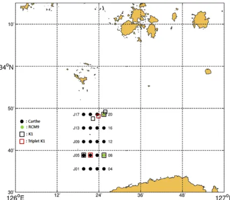
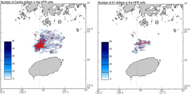
When checking the HFR, the error can be reduced by using floating buoys within 1 meter of the sea level. In the April experiment, all the buoy passed through the north sea of Tsushima Island, but in the November experiments, it passed north and south of the island. Analysis of turbulent flow characteristics using statistical models - Diffusion statistics occur in Jeju Strait and Korea Strait.
In the Korea Strait, where the temperature front was strong, mesoscale circulations drove the turbulent flow diffusion. When the correlation between the PC2 and 500hPa Geopotential height is obtained, for high temperature in the east-west pattern, the atmospheric high pressure is strengthened, which means a great connection with the heat wave.
Application plan of results and products
Due to the increase in temperature associated with global warming, the catch of cold water fish such as pollock and Pacific saury decreased, while the catch of warm water fish (i.e. mackerel, anchovy and squid) gradually increased since from 1990.
재분석자료 검증을 위한 제주해협 해류. 재분석 자료에 근거한 고온 저염분 현상의 구조. 위성자료를 이용한 한반도 열수현상의 특성 분석.
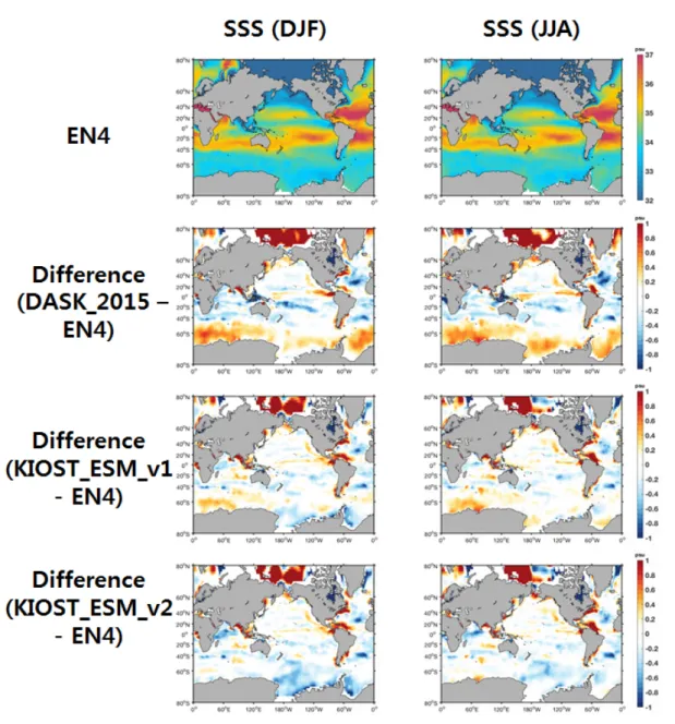
해양재분석자료를 이용한 북서태평양의 물리현상 연구. 위성 관측 해수면 데이터 동화를 위한 방법이 개발되었습니다. 재분석 데이터의 표층과 이에 대한 관측 데이터의 차이.
운송 계산을 이용한 재분석 데이터 평가를 제외하고는 일반적으로 음의 편향이 발견되었습니다. 대만 남동부 아열대 해역의 재분석 자료와 관측 자료 간의 무작위 소용돌이 분포 비교.
재분석자료와 관측자료의 임의수분포 특성 비교. 단파(고주파) 대역을 이용하여 실시간으로 넓은 바다의 표층 해류. 일반적으로 해류를 관측하기 위해서는 대형 데이터 수집 부표에 유속계를 설치하는 것이 일반적이다.
고주파 레이더로 관측한 제주 북해상 표층류 자료 정확도 분석. 일반적으로 발산 성분은 1km 미만의 규모에서 강하게 나타났다. 이는 라그랑주 관찰이 편향된 정보를 제공할 수 있기 때문입니다.
수면 부이 데이터 결과와 분석 및 비교를 할 계획이다. 위성 데이터 기반 고온 감지 기술 개발 상승 추세는 안정적이지만 경년 변동성은 상당히 큰 것으로 보입니다.
재분석 자료를 이용한 아열대 해역의 소용돌이 무작위 분포 검증.