ӘЛ-ФАРАБИ атындағы ҚАЗАҚ ҰЛТТЫҚ УНИВЕРСИТЕТІ
ХАБАРШЫ
География сериясы
КАЗАХСКИЙ НАЦИОНАЛЬНЫЙ УНИВЕРСИТЕТ имени АЛЬ-ФАРАБИ
ВЕСТНИК
Серия географическая
AL-FARABI KAZAKH NATIONAL UNIVERSITY
JOURNAL
of Geography and Environmental Management
№3 (58)
Алматы
«Қазақ университеті»
2020
ХАБАРШЫ
ГЕОГРАФИЯ СЕРИЯСЫ №3 (58) қыркүйек
04.05.2017 ж. Қазақстан Республикасының Мәдениет, ақпарат және қоғамдық келісім министрлігінде тіркелген
Куәлік №16502-Ж.
Журнал жылына 4 рет жарыққа шығады
ИБ №13892
Пішімі 60х84 1/8. Көлемі 8.7 б.т. Офсетті қағаз. Сандық басылыс.
Тапсырыс №12603. Таралымы 500 дана. Бағасы келісімді.
Әл-Фараби атындағы Қазақ ұлттық университетінің
«Қазақ университеті» баспа үйі.
050040, Алматы қаласы, әл-Фараби даңғылы, 71.
«Қазақ университеті» баспа үйінің баспаханасында басылды.
© Әл-Фараби атындағы ҚазҰУ, 2020 РЕДАКЦИЯ АЛҚАСЫ:
Қалиасқарова З.К., г.ғ.к., профессор м.а. – ғылыми редактор (Қазақстан)
Шокпарова Д.К., PhD, доцент м.а., ғылыми редактордың орынбасары (Қазақстан)
Аскарова М.А., г.ғ.д., профессор м.а. (Қазақстан) Плохих Р.В., г.ғ.д., профессор м.а. (Қазақстан) Бексеитова Р.Т., г.ғ.д., профессор (Қазақстан) Кожаев Ж.Т., PhD, аға оқытушы (Қазақстан) Нысанбаева А.С., г.ғ.к., аға оқытушы (Қазақстан) Гельдыев Б.В., г.ғ.к., доцент (Қазақстан) Ивкина Н.И., г.ғ.к., доцент (Қазақстан)
Родионова И.А., г.ғ.д., профессор (Ресей) Béla Márkus (Белла Маркус) профессор (Венгрия) Fernandez De Arroyeabe Pablo (Фернандес Де Арройеб Пабло), профессор (Испания)
Севастьянов В.В., г.ғ.д., профессор (Ресей) Бобушев Т.С., г.ғ.д., профессор (Қырғызстан) Мазбаев О.Б., г.ғ.д., профессор (Қазақстан) Исанова Г.Т., PhD (Қазақстан)
Кристиан Опп, профессор (Германия) ТЕХНИКАЛЫҚ ХАТШЫ Ерболқызы С., (Қазақстан) ЖАУАПТЫ ХАТШЫ
Нарбаева К.Т., PhD, доцент м.а.
(Қазақстан)
e-mail: [email protected]
Тақырыптық бағыты: қоршаған орта туралы ғылымдар, география, метеорология, гидрология, туризм, экология, геодезия, картография, геоақпараттық жүйелер, жерді қашықтықтан зондылау.
ВЕСТНИК
ХАБАРШЫ Г Е О Г Р А Ф И Я С Е Р И Я С Ы С Е Р И Я Г Е О Г Р А Ф И Ч Е С К А Я
КАЗАХСКИЙ НАЦИОНАЛЬНЫЙ УНИВЕРСИТЕТ имени АЛЬ-ФАРАБИAL-FARABI KAZAKH
NATIONAL UNIVERSITY ӘЛ-ФАРАБИ атындағы ҚАЗАҚ ҰЛТТЫҚ УНИВЕРСИТЕТІ
3(58) 2020
OF GEOGRAPHY AND ENVIRONMENTAL MANAGEMENTJOURNAL
Жоба менеджері Гульмира Шаккозова Телефон: +7 701 7242911
E-mail: [email protected] Редакторлары:
Гульмира Бекбердиева Ағила Хасанқызы Компьютерде беттеген Айша Калиева
КАРТОГРАФИЯ ЖӘНЕ ГЕОИНФОРМАТИКА
Section 1
CARTOGRAPHY AND GEOINFORMATICS
Раздел 1
КАРТОГРАФИЯ
И ГЕОИНФОРМАТИКА
IRSTI 36.33.23 https://doi.org/10.26577/JGEM.2020.v58.i3.01
Sh. Burlibayeva1*, R. Bexeitova1 , R. Shults2
1Al-Farabi Kazakh National University, Kazakhstan, Almaty,
2Michigan Technological University, USA, Michigan
*e-mail: [email protected]
ROLE AND IMPORTANCE OF GEODETIC SURVEYS IN GEODYNAMICS
In science geodynamics has been actively developing as a new direction recently, especially in the last decade. For the first time this term was described in A. Liyav’s monograph 90 years ago. A. Liyav himself formed this term as a relationship of the Earth and space factors, as well as a legal regmatic formation of cracks-light grid on the entire surface of the bottom and the entire planet surface. In the last 20 years, the meaning of geodynamics is often used in a slightly modified version, so geodynamics has become under- stood as the whole complex of development processes inside the Earth. In the foreign literature, geodynam- ics is understood to be a branch of geology engaged in the study of forces and processes that occur only in the interior of the Earth and cause the formation of disorderly structures and deformations in its shells.
Subsequently, E. Og considered geodynamics as a section of tectonics, studying the forces affecting the planet and phenomena occurring on its surface. In other foreign sources, modern geodynamics is the sci- ence of Earth’s movements in real time, which can be measured, identified and explained in the language of fundamental sciences. The purpose and task of this work is to make a general overview of the results of geodesic research in geodynamics, considering geodynamics as a new direction of science.
Key words: geodynamics, geodesy, geology, quarries, mineral extraction.
Ш.М. Бурлибаева1*, Р.Т. Бексеитова1, Р. Шульц2
1Әл-Фараби атындағы Қазақ ұлттық университеті, Қазақстан, Алматы қ.
2Мичиган технологиялық университеті, АҚШ, Мичиган қ.
*e-mail: [email protected]
Геодинамикадағы геодезиялық ізденістердің рөлі мен мәні
Ғылымда геодинамика жаңа бағыт ретінде соңғы уақыттарда, әсіресе соңғы он жылдықта белсенді дамып келеді. Ең алғаш рет бұл термин А. Лявтың монографиясында 90 жыл бұрын қолданылған болатын. А. Лявтың өзі бұл терминді Жер мен ғарыштық факторлардың өзара байланысы, сонымен қатар түбіндегі ағын мен планетаның барлық жоғарғы бетіндегі сызат- жарық торының заңды регматикалық түзілуі деп қалыптастырған болатын. Соңғы 20 жылда геодинамика сөзінің мағынасы біршама өзгеріске ұшырады. Кейбір мәліметтер бойынша, Э.Ог геодинамиканы Жерге әсер ететін күштерді сипаттайтын тектониканың бір бөлімі ретінде қарастырған. Геодинамиканың астарында Жердің ішкі қабатындағы процестердің кешенді дамуын қарастыруға болады. Басқа шетелдік дерек көздерде қазіргі геодинамика – бұл уақыттың нақты масштабындағы Жердің қозғалысы туралы ғылым, яғни іргелі ғылымдар ретінде өлшеуге, анықтауға және түсіндіруге болатын қозғалыстарға сілтеме жасау. Соңғы 30 жылдарда әлемдік ғылымның қалыптасуымен әр түрлі болжамдар мен ескертпелердің орнына литосфералық тақталар тектоникасы теориясының, мазмұнды термині көптеген көп қырлы монографияларда, сөздіктерде және кітаптарда айтарлықтай өзгерді. Шетел әдебиеттерінде геодинамика негізінде Жердің ішкі бөліктерінде болып жататын процестер мен оларға әсер ететін күштер арқылы геология саласы туралы түсінік пайда бола бастады. Бұл жұмыстың мақсаты мен міндеті – геодинамиканы ғылымның жаңа бағыты ретінде қарастыра отырып, геодинамикадағы геодезиялық ізденістердің нәтижесіне жалпы шолу жасау.
Түйін сөздер: геодинамика, геодезия, геология, карьерлер, пайдалы қазбаларды өндіру.
Ш.М. Бурлибаева1*, Р.Т. Бексеитова1, Р. Шульц2
1Казахский национальный университет имени аль-Фараби, Казахстан, г. Алматы
2Мичиганский технологический университет, США, г. Мичиган
*e-mail: [email protected]
Роль и значение геодезических изысканий в геодинамике
Наука геодинамика активно развивается как новое направление в последнее время, особенно в последнее десятилетие. Впервые этот термин был описан в монографии А. Лява 90 лет назад как взаимосвязь Земли и космических факторов, а также законное регматическое образование трещин – световой сетки на всей поверхности дна и всей поверхности планеты. В последние 20 лет определение геодинамики часто используется в несколько ином варианте, так под геодинамикой стали понимать весь комплекс процессов развития внутри Земли. В зарубежной же литературе под геодинамикой стала пониматься отрасль геологии, занимающаяся изучением сил и процессов, происходящих только во внутренних частях Земли и обуславливающих формирование разнопорядковых структур и деформаций в ее оболочках. Впоследствии Э. Ог рассматривал геодинамику как раздел тектоники, изучающий силы, воздействующие на планету и явления, происходящие на ее поверхности. В других же иностранных источниках современная геодинамика представляет собой науку о движениях Земли в реальном масштабе времени, то есть ссылаясь на те движения, которые можно измерять, идентифицировать и объяснять на языке фундаментальных наук. Цель и задача этой работы - сделать общий обзор результатов геодезических изысканий в геодинамике, рассматривая геодинамику как новое направление науки.
Ключевые слова: геодинамика, геодезия, геология, карьеры, добыча полезных ископаемых.
Introduction
Geodynamics was first used in the monographA.
Liyav 90 years ago. A. Liyav formed it as a relationship between the dynamics of the Earth and space factors leading to the formation of tides in the crust and the formation of regular regmatical grid of cracks and ruptures across the surface of the planet. Over the past 20 years, geodynamics has often been used in a slightly modified way.
Under geodynamics began to understand the whole complex of development processes inside the earth, at that moment in the foreign literature under geodynamics began to be understood the branch of geology engaged in studying of forces and the processes occurring only in internal parts of the earth and causing formation of various structures and deformations in its shells (Yudin, 2005:21-24).
The current geodynamics of the continental lithosphere should be considered as a result of the interaction of a complex of natural endo-dynamicand outsidedynamic processes(geological processes that occur in the Earth’s interior depending on the internal energy, gravity, and forces that occur when the Earth rotates), the elucidation of causal links between which often represents an independent scientific problem. Its solution opens the way for revealing regularities of geodynamic processes variations in time and space. The most important is the medium-term forecast of socially dangerous phenomena, which are often catastrophic in nature.
Integrated information on the geodynamic state of large regions is usually reflected in geological maps.
At present, they are practically the most popular documents, which are the basis of the exploited and planned for the development of social and economic protections.
Fully completed tasks on the integration project, their generalization combined with some results of work on other projects, allowed to get a new idea of the geological structure of Asia and to draw a map of modern geodynamics of Asia. It is based on the data on the stress state of the lithosphere, which provides an opportunity to consider the relationship between the formation of structures and processes in the lithosphere of Asia from a new angle of view. At the current level of knowledge, only a comprehensive analysis of geological and geophysical observations allows us to create a model of geological development of the continental lithosphere that is close to reality.
On its theoretical basis, socially important works on the forecast of natural, including cataclysmic, processes can be continued (Levi, 2005: 254-261).
Materials and methods of research
Geodynamics is a subfield of geophysics dealing with the Earth’s dynamics. It applies physics, chemistry and mathematics to the understanding of how mantle convection leads to plate tectonics and geologic phenomena such as seafloor spreading, mountain building, volcanoes, earthquakes, faulting and so on. It also attempts to probe the internal activity by measuring magnetic fields, gravity and seismic waves, as well as the mineralogy of rocks and their isotopic composition. Methods of geodynamics are also applied forexploration of other planets.
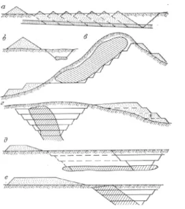
V. A. Ovchinnikov’s data testifies to the fact that the peculiarities of the developed relief forms during the quarry production are determined by the conditions of the deposit occurrence (Figure 1). At the same time, the shape of accumulating bodies depends to a certain extent on the waste rock dumping technology.
Having analyzed the known maps of geodynamics (Zonenshain, et all., 1988: 112; Map of Newest Tectonics…, 1998), other editions and having taken all the best of them, the authors have come to toe conclusion that on maps of modern geodynamics it is necessary to display only the main complex of various components of endogenous and exogenous situations. This allows, on the one hand, to reveal the regularities of spatial distribution and variations of one process, and on the other hand, to determine the areas of “superimposition” of different processes, where their interaction can lead to the initiation of other processes, including catastrophic ones.
The most important endo-dynamic components that determine the state of the lithosphere at the present stage of its evolution have been estimated:
the thickness of the lithosphere, its stress state, active faults and their density, seismicity, volcanism and kinematics of horizontal movements of large blocks.
The thickness of the lithosphere L (km) was estimated by the equation lnL=320.4e-0.017q, where q is the heat flux (mWt/m2) averaged over a grid of 50*50 (Levi, 1991). The correlation ratio
determined for this equation is 0.9 with a sample size of about 200 pairs of values. Variations in the thickness of the lithosphere reaches 200-250 km or more abruptly decreases to 70- 100 km under the modern mobile belts. Variations in the thickness of the lithosphere within different geodynamic regions cause changes in its stress-strain state, the de gradient of tectonic motion speed and density of active faults, without which the manifestation of block tectonic movements is impossible (layer 1). The density of active faults was determined by honoring their number N in a window of 5°x5°. Within Asia, it varied from 0 to 40 units:
the minimum on cratons is maximum in modern submerged areas. An increase in the number of active faults in the regions of the relatively thin lithosphere is clearly visible. The growth of their number leads to an increase in heat outflow from the bowels, additional heat due to the deformation of the lithosphere layers and friction on the fracture planes in the process of tectonic blocks movement. All this causes relative overheating of the upper lithosphere and changes in its rheological properties.
Results and discussion
Let’s briefly characterize the active faults of Asia.
They are usually understood as breaks with signs of tectonic movement in historical time or, more broadly, during the Holocene - the late Pleistocene.
They reflect the manifestation of modern tectonic
Figure 1 – Relief, which forms during the opencast development of various types of fields These measures lead to the most significant changes in terrain. The amplitude of heights between the bottoms of the deepest excavations and the highest dumps has now exceeded 1100 m. Information on changes in the relief of land during the extraction
of solid minerals is systematized by V. A. Ovchinnikov
activity. The undisputed signs of movement are the observed surface deformation and displacement of Late Pleistocene and Holocene sediments and relief elements (Fault Activity Map…, 1987;
Geodynamics…, 2000). Rift activity indicators include geodetic data on modern movements in their planes, linear location of Holocene volcanoes and earthquake epicenters. Active faults are mapped by ground-based observation and interpretation of aerospace materials.
Taking into account the peculiarity of the stress- strain state of the lithosphere, they are offen classified by morphogenetic accessories. The known data on the size and age of Holocene displacements made it possible in many cases to estimate the velocity of movements along the fault plane. At impulse movements connected with earthquakes, the average speed for large time intervals was calculated taking into account the frequency of occurrence of seismic events.
Here is a brief regional overview of the largest active fault zones and their main parameters. In the Caucasus, Late Pleistocene – Holocene and modern active movements are carried out mainly through the already known modern faults. At the present stage the most active ruptures of the “Caucasian”
(Western from the North-Western) and “anti- Caucasian” (North-Eastern) stretches are the most active (Koshelev, 1991).
Mining relocation activities
Pit mining. This way of extracting mineral resources, due to the possibility of its progressive cheapening, is increasingly replacing the competitive underground mining operations. According to E.
P. Doronenko, the cost of extraction of 1 ton of
raw ore by open-cut method is 3-3.5 times higher in comparison with the underground method of extraction of the mineral resource.
The open-pit mining method achieves a mere complete extraction of minerals. The possibility to create deep quarries (some of them have depths of more than 700 m) is associated with the use of highly profitable equipment. For example, in Canada, in preparation for open pit mining, a copper- nickel ore deposit for overburden removal of 11.5 million tonnes of overburden is being prepared. m3 a hydraulic suction dredge is used. Water for it was supplied from the nearest lake and there was also sucked rock. The elliptical excavation reaches a length of 1.1 km and a width of 0.6 km. Recently, Arizona (USA) began mining copper ore from the open pit, with a total of 113. 3 million tonnes of open pit material м3.
Currently, the share of open-pit mining in the global mining industry is 66%. The share of ores of different metals extracted by this method is 57%, coal -34%
and construction materials – 97%.
In the United States, the share of open pitor pitmining in mineral production is 84%. The open- pit mines receive 85% of the total number of ores mined and 42% of the coal.
In the USSR, the development of mineral deposits by quarrying is rapidly increasing. In 1975, the volume of stripping work in the USSR amounted to 2.2 billion and by 1990, it’s increasing several times.
The share of open-pit mining with the production capacity of up to 1 billion tons is decreasing. In 1975, as compared to 1970, the number of such quarries in the USSR Ministry of Economic Development and Trade decreased and amounted to 39.3% of the total number of quarries, with a specific weight of 3.1%
of production volumes.
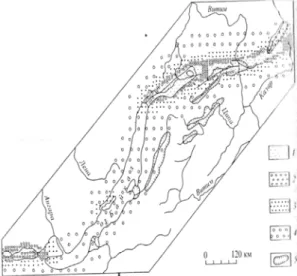
Figure 2 – The scheme of zoning of regional voltage fields in the Baikal rift zone (Sherman, 1989)
The depth of the quarries increased by 30-50 m or more from 1970 to 1975 at an average annual rate of deepening from 5 to 12 m. Thus, in 1975, the share of quarries with depths from 100 to 250 m increased from 28.3% to 36.1% in the USSR Ministry of Culture. According to N.A.Bykhover, the share of the open-pit mining method in its total volume is now 81% for iron ores and for others;
for manganese ores – 78.7%, for ores of non- ferrous metals -64%, for mining and space raw materials -82% and for other non-metallic minerals
and building materials – almost 100%. According to V. N. Novozhilov, as of the end of the 1970s, there were more than 3500 quarries in the USSR, of which more than 30 are over 150 m deep, the height of dumps in some quarries reaches 100 m (in the project - 400 m and more); the volumes of separate tailings dumps 100-250 million м3(in the project 500 million, м3). The deepest are the Korkinsky coal pits in the Chelyabinsk Region - 470 m. The design depth of some quarries exceeds the mark of 600 and 700 m (Morgan, 2017).
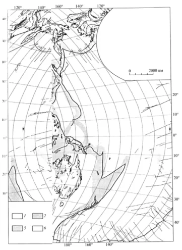
Figure 3 – International tectonic map of the world 1-6 – types of intense; 2 – shear tensile, σZ =σy>> σx; 3 – shift, σx>σZ>σy; 4 – shear compression; 8 – the boundaries of the major plates of lithosphere; 9 – faults (a)
In case of quarry mining, the following operations are carried out: 1) removal of overburden rocks and formation of dumps, 2) construction of ditches for drainage of surface waters and accumulation of dumps, 3) extraction of mineral resources, 4) formation of dumps from tailings and ore concentration.
Geodynamics is a broad field which combines observations from many different types of geological
study into a broad picture of the dynamics of Earth.
Close to the surface of the Earth, data includes field observations, geodesy, radiometric dating, petrology, mineralogy, drilling boreholes and remote sensing techniques experiments
These measures lead to the most significant changes in terrain. The amplitude of heights between the bottoms of the deepest excavations and the highest dumps has now exceeded 1100 m. Information about
changes in the relief of land during the extraction of solid minerals is systematized by V. A. Ovchinnikov.
Here are some of the data relating to the results of the quarrying and processing of mineral resources.
Geo ecological studies of the formation of very dangerous for mankind natural soufflars have shown that their geodynamic development depends on both toe peculiarities of the geological and tectonic structure of the mine fields (positive plicative structures, faults in the kernels of anticlines, gas weathering and other factors). Keywords: soufflars, geo-ecology, geodynamics, anticline nuclei, gas saturation. Kuznetsk coal basin (Kuzbass) is one of the largest coal deposits of the Russian Federation and is administratively located in the south of Western Siberia, in the territory of the Kemerovskaya oblast (Levi, 2005: 254-261). the practice of coal mining shows that almost all underground mine workings of the Kuznetsk basin connected with mines of various depths, in which methane with impurities of hydrocarbons, hydrogen and helium are mainly renewed everywhere, belong to explosive on gas.
The most dangerous types of catastrophes associated with toe presence of soufflars in the rocks and coals of the described basin are given from the point of view of geo-ecology:
– sudden methane emissions,
– the explosion of methane soufflars together with coal dust,
– the soufflars and the underground fire connection with them. This article will focus on the nature and dynamics of the early Permian soufflar formation.
In the Kuznetsk Basin, there are three types of disturbance of the horizontal occurrence of rocks. plicated (folded), disjunctive (explosive) and injectable (amagmatic) dislocations. The most widespread, almost everywhere, are various, mainly with block movements of the ancient crystal bed of the basin in the category with horizontal movements of the Earth’s crust of the collision type. Folded dislocations are represented by a wide range of structures of different orders – folds with the length of tens of kilometers and amplitude up to 1000 and more meters, up to microforms with the size of the first the early Permian soufflar formation. In the Kuznetsk Basin, there are three types of disturbance
of the horizontal occurrence of rocks. plicated (folded), disjunctive (explosive) and injectable (amagmatic) dislocations. The most widespread, almost everywhere, are various, mainly with block movements of the ancient crystal bed of the basin in the category with horizontalmovements of the Earth’s crust of the collision type (S.P.Gorschkov, 1996:184- 197). Folded dislocations are represented by a wide range of structures of different orders – folds with the length of tens of kilometers and amplitude up to 1000 and more meters, up to microforms with the size of the first meters. Breaking dislocations are also excellent in shape and size - from regional faults with a length of more than 100 km and an amplitude of up to 1-3 km to subtle hollow cracks. Almost all large and overwhelming majority of ruptures with different amplitudes are represented by the structures of discharges and overthrust discharges formed, as our studies have shown, in the geodynamic conditions of large-scale compression and collision of the coal basin as a whole, especially in the mountainous Salaira part of it. Up along the section, the deep faults slowly fade out, which is well observed in the predominantly thick Paleozoic deposits of the roof of the composite section of the productive Paleozoic (S.P.Gorschkov, 1996:184-197).
Conclusion
This article was written according to theoretic materials and it gives general explanation of geodynamics. In conclusion, the current geodynamics of the continental lithosphere should be considered as a result of the interaction of a complex of natural endos and exo dynamic processes, the elucidation of causal links between which often represents an independent scientific problem. Its solution opens the way for revealing regularities of geodynamic processes variations in time and space. The most important is the medium-term forecast of socially dangerous phenomena, which are often catastrophic in nature. Integrated information on the geodynamic state of large regions is usually reflected in geological maps. At present, they are practically the most popular documents, which are the basis of the exploited and planned for the development of social and economic protections.
References
Levi C.G., Sherman S. I. (2005) [Topical issues of modern geodynamics in Central Asia]. Novosibirsk, pp. 254-261.
Yudin V. V. (2005) [About the concepts of geodynamics and eco geo dynamics]. Simferopol Gorschkov S.P. (1996) [Exodynamic processes of the developed territories]. Moscow , pp. 184-197.
Morgan J.P. (22 September 2017)[Central Asia metals plc Peel hunt LLP (Securities plc compotent persons report on the Koun- rad copper in situ dump lich asset) Central Kazakhstan].
Koshelev V.K. (1992) [Models of mineral deposits and computer – based quantitative prediction of mineralization in Kazakh- stan]. Kyoto, Japan.
Satpayeva M.K. (1985) Rudy Zhazkazgana i usloviya ih formirovaniya[Ores of Zhezkazgan and conditions its formation]. Alma-Ata, P.208
Frankovskaiya N.M. (1979) Kompleksnaiya interpretatsiya geohimicheskih anomalii v rudnyh raiyonah Kazakhstana [Сomplex interpretation of geochemical anomalies in the ore regions of Kazakhstan ]. Irkutsk, p. 26.
Frankovskaiya N.M., Koshelev V.K. (1985) Opyt kolichestvennogo prognozirovaniya orudeneniya na EVM v Kazakhstane//
Osnovnye napravleniya razrabotki kolichestvennyh metodov prognozirovaniya naftiyanyh i rudnyh mestorozhdenii [Experience of quantitative prediction of mineralization on a computer in Kazakhstan// Main directions of developing quantitative methods for predicting oil and ore fields]. Mezhdunarodnyi symposium. Alma-Ata, p. 103.
Polikarpochkin V. V. (1962) Geohimicheskie poiski rudnyh mestorozhdenii po potokam rasseiyaniya [Geochemical searches for ore fields by scattering fluxes]. pp. 63-76.
Popov V.M. (1970) Problema proishozhdeniya stratiformnyh mestorozhdenii i puti eiyo resheniya.Litologiya i poleznye is- kopaemye [Lithology and minerals ]. №2. pp. 89-106
Radkevich E. A. (1955) O tipah vertikal’noi i gorizontal’noi zonal’nosti [About types of vertical and horizontal zoning]. №9.
pp. 70-85.
French, S.W., Romanowicz, B. (2015). Broad plumes rooted at the base of the Earth’s mantle beneath major hotspots. Nature 525 (7567), pp. 95–99.
Friedmann, S.J., Burbank, D.W. (1995). Rift basins and supradetachment basins: intracontinental extensional end-members.
Basin Res. 7 (2), pp. 109–127.
Hart, J.K., Martinez, K. (2006). Environmental sensor networks: A revolution in the earth system science? Earth Sci. Rev. 78 (3–4), pp. 177–191.
Dooley, T.P., Jackson, M.P.A., Hudec, M.R. (2009). Inflation and deflation of deeply buried salt stocks during lateral shortening.
J. Struct. Geol. 31 (6), pp. 582–600.
Head, J.W. (1977). Origin of outer rings in lunar multi-ringed basins, Evidence from morphology and ring. In: Roddy, D.J., Pepin, R.O., Merrill, R.B. (Eds.), Impact and explosion cratering: Planetary and terrestrial implications. Pergamon Press, Inc, New York, pp. 563–573.
Talwani P. On the nature of reservoir-induced seismicity, Pure Appl. Geophys. 150 (1997) 473e492.
Trinh N.Q., Panthi K.K. (2014) Evaluation of seismic events occurred after filling and drawdown of the reservoir at song tranh 2 HPP in vietnam, Hydro Nepal 15 16e20.
МЕТЕОРОЛОГИЯ ЖӘНЕ ГИДРОЛОГИЯ
Section 2
METEOROLOGY AND HYDROLOGY
Раздел 2
МЕТЕОРОЛОГИЯ
И ГИДРОЛОГИЯ
IRSTI 87.19.91 https://doi.org/10.26577/JGEM.2020.v58.i3.02
S.B. Bissenbayeva*
State Key Laboratory of Desert and Oasis Ecology, Xinjiang Institute of Ecology and Geography, Chinese Academy of Sciences, China, Urumqi
*e-mail: [email protected]
HUMAN ACTIVITIES IN THE SYRDARYA RIVER BASIN
Changes in land use and water use can greatly impact the cycling of water and water-borne sub- stances. Increased redistribution of river water to irrigated fields can cause enhanced evapotranspiration and decreased river discharge. Additionally, the water quality can be affected by the external input of fertilisers and pesticides, and by changed pollutant transport pathways in expansive irrigation canal sys- tems. This work examines basin-scale changes in water use, land cover/use change (LLUC), water quality under conditions of intensified irrigated agriculture, development water constructions. When consider- ing land use in the basin, it can be noted that most of the land is grassland (about 42%) and cropland (about 28%). A comparative analysis of 1992 and 2015 revealed that bare land and forestland area decreases. The percentage of the urban area during the increased to 1.0% during the study periods. The urban area expanded most rapidly mainly by encroaching into the agricultural area and grassland. More- over, it revealed that over the long-term period the water construction was intensively taking placed in the basin. Especially since the 1960s. The construction of reservoirs and the increase in water withdrawal from rivers significantly changed their water regime, especially in the downstream. In fact, due to agri- cultural, industrial, and urban development’s, such as irrigation and drainage, hydraulic structure across a river, the elements of the hydrological cycle have changed in terms of quantity and quality, both in time and space. In this work, an attempt is made to analyze the effect of human activity on river runoff.
Key words: human activities, land cover/use, irrigation, water withdraw, water construction.
С.Б. Бисенбаева*
Шөл және оазис экологиясының мемлекеттік негізгі зертханасы, Қытай ғылым академиясының Синьцзян экология және география институты, Қытай, Үрімші қ.
*e-mail: [email protected]
Сырдария өзені алабындағы адам әрекеті
Жерді пайдалану мен суды пайдаланудың өзгеруі су айналымына және суда тасымалданатын заттарға қатты әсер етуі мүмкін. Өзен суын суармалы егістікке қайта бөлудің артуы буланудың жоғарылауына және өзен ағынының азаюына әкелуі ықтимал. Сонымен қатар, сырттан тыңайтқыштар мен пестицидтердің енуі, сондай-ақ кең суармалы каналдар жүйесіндегі ластаушы заттардың тасымалдану жолдарының өзгеруі судың сапасына әсер етуі мүмкін. Бұл жұмыста өзен алабы масштабында суды пайдалану, жер жамылғысы мен жерді пайдалану, интенсивті суармалы егіншілік жағдайындағы су сапасы және су құрылымдарының дамуы өзгерістері зерттелінеді. Өзен алабындағы жерді пайдалануды қарастырған кезде, жердің көп бөлігі жайылым (шамамен 42%) және егіншілік жерлер (шамамен 28%) екенін атап өтуге болады. 1992 және 2015 жылдардағы салыстырмалы талдау көрсеткендей, пайдаланылмайтын және орманды жерлер ауданы азайып келеді. Зерттеу кезеңінде қалалық жердің үлесі 1,0% дейін өсті. Әсіресе, елді-мекен аймақтары тез өсіп келеді, негізінен ауылшаруашылық жерлері мен жайылымдар есебінен. Сонымен қатар, ұзақ уақыт бойы су құрылыстары өзен алабында қарқынды түрде жүргізілген болатын. 1960 жылдан бастап су қоймаларының салынуы және өзен суын алудың көбеюі олардың су режимін айтарлықтай өзгертті, әсіресе өзеннің төменгі ағысында. Шындығында, суару және дренаж, гидротехникалық құрылыстар сияқты ауылшаруашылық және өндірістік кешеннің дамуына, сондай-ақ елді-мекендердің ұлғаюына байланысты гидрологиялық цикл элементтері уақыт бойынша да, кеңістікте де саны мен сапасы жағынан өзгерді. Бұл жұмыс адам іс-әрекетінің өзен ағынына әсерін талдауға тырысады.
Түйін сөздер: адамның іс-әрекеті, жер жамылғысы, жер суағару, су алу, су құрылысы.
С.Б. Бисенбаева
Государственная ключевая лаборатория экологии пустынь и оазисов, Синьцзянский институт экологии и географии Китайской Академии Наук, Китай, г. Урумчи,
e-mail: [email protected]
Человеческая деятельность в бассейне реки Cырдарья
Изменения в землепользовании и водопользовании могут сильно повлиять на круговорот воды и переносимых водой веществ. Повышенное перераспределение речной воды на орошаемые поля может вызвать усиление испарения и уменьшение речного стока. Кроме того, на качество воды может повлиять поступление удобрений и пестицидов извне, а также изменение путей переноса загрязнителей в обширных системах оросительных каналов. В данной работе исследуются изменения в водопользовании в масштабе бассейна, изменение покрова земли и их использования, качество воды в условиях интенсивного орошаемого земледелия, развитие водных сооружений. При рассмотрении землепользования в бассейне можно отметить, что большая часть земель - это пастбища (около 42%) и пахотные земли (около 28%). Сравнительный анализ 1992 и 2015 годов показал, что площадь неиспользуемых земель и лесных массивов уменьшается. Доля городской территории в период исследования увеличилась до 1,0% в период исследования. Особенно застроенные регионы росли быстрее всего, в основном за счет сельскохозяйственных земель и пастбищ. Более того, выяснилось, что в течение длительного периода водные сооружения интенсивно размещались в речном бассейне. Начиная с 1960-х гг. строительство водохранилищ и увеличение забора воды из рек существенно изменили их водный режим, особенно в нижнем течении. Фактически, из-за развития сельскохозяйственного, промышленного комплекса, такого как ирригация и осушение, гидравлические сооружения, а также увеличения населенных пунктов, элементы гидрологического цикла изменились с точки зрения количества и качества как во времени, так и в пространстве. В этой главе делается попытка проанализировать влияние человеческой деятельности на речной сток.
Ключевые слова: человеческая деятельность, земельный покров, орошение, водозабор, водное строительство.
Introduction
Human activity has the potential to indirectly and directly affect water quantity and the natural flow regime of a river system. Indirect impacts to the hydrologic cycle can result from land cover/
use changes. Direct impacts can result from water diversions, withdrawals and discharges, and from dams (flow regulation and water storage). In each river basin, if not all, then most of the factors mentioned can act. At the same time, in a specific basin, some factors are the main, while others are secondary.
Since the middle of the 21st century, dramatic changes in flow influenced by human activities (e.g., water diversion and land use/cover change) have been detected in many basins (Marengo, Tomasella, and Uvo 1998; Milly et al. 2008; Ma et al., 2010). Human activity, such as land cover/
use change, urbanization, and water conservation projects have significant impacts on river water, altering the regional hydrologic cycle by changing runoff-generation conditions (Deng and Chen 2017). The existing extent of human- generated change to land cover has increased global runoff by 7.6% and reduced global annual average terrestrial evapotranspiration by 5%,
which is approximately equivalent in volume to annual global surface water withdrawals (3200km3/year) (Sterling, Ducharne, and Polcher 2013; Piao et al, 2007) indicated that land use change increased global runoff by 0.08 mm/year, which accounted for approximately 50 % of the reconstructed global runoff trend over the last century (Zhang et al. 2015).However, different human activities may have different roles in runoff change. Experimental studies indicate that the runoff modulus of grassland is 61.1%–75.8%
of that of bare land; forest land has a lower runoff modulus as compared to that of bare land; while the runoff modulus in urban areas is much higher (Chen, Wang, and Xu, 2004). At the same time, industrial water consumptions and agricultural water consumptions have a direct impact on river flow, with agriculture accounting for over 70% of total water use (Zhang, 2005).
In arid and semi-arid zones (such as Central Asia), irrigation is the main anthropogenic factor.
However, in these areas, there is drainage of waterlogged lands, regulation of runoff over time and territory, industrial and communal water consumption. Their role, in most cases, is secondary, although some of them in certain periods of time are of primary importance.
Assessment of human impact on water resources is most relevant for regions and river basins with developed irrigated agriculture, where water scarcity is already present. Several studies (Cai, McKinney, and Rosegrant, 2003; Petr, 2003) conducted to analyze the impact of irrigated agriculture and economic activity on the water balance and water resources of the main river watersheds in the arid zone showed that irrigation leads to a radical change in the ratio of the components of heat, water and salt balances both within the irrigated massifs and on adjacent lands and water bodies (lakes, rivers, reservoirs). Depending on the extent of irrigation, climatic and physical-geographical features of the territory, the trend of runoff reduction can be significantly different.
At present, a catastrophic water-ecological situation has developed in the Syr Darya river basin, which is explained, first of all, by its transboundary position, as well as by the confluence of the lower part of the basin to arid inland areas where the river almost does not accept tributaries (Dukhovny and Litvak, 1977). About half of the population of Central Asia is concentrated in the Syr Darya river basin. Agriculture in the river basin and the industry have obtained a high economic level, notably within Uzbekistan. Large reserves of thermal resources and the availability of fertile land, on the one hand, and a lack of precipitation, on the other hand, led to the widespread development of irrigation. Therefore, the water resources of the basin, especially river waters, which are mainly used for these purposes, undergo some quantitative and qualitative changes (Amirgaliev, 2007).
Since ancient times, the river basin has been used as irrigation land. But from 1950-1960 of the 20th century, irrigation lands grew 3-5 times. Which led to an increase in water intake from the river.
Also, from the 1950s, water construction in the river basin began intensively. As we know, in the lower river, in the second half of the last century, the Syr Darya acutely felt a shortage of water, and about 30 years ago, runoff at its mouth was reduced to almost zero. But at the end of the 80s on the territory of the former USSR, people’s views on the state of the environment changed significantly, and the population of the Syr Darya became more careful about water resources. As a result, already in the early 1990s, Syr Darya Basin water began to flow regularly into the northern part of the Aral Sea.
Although the volume of this water was about 2-4 times less than the amount of natural runoff (14.9 km3), it was enough to flood a significant part of
the modern “Small Aral” and there the desalination process began. Currently, the annual runoff at the mouth of the Syr Darya river ranges from 3.6 to 9.0 km3(Sambaev 2017).
In the work we want to analyze human activity in the river basin by the dominant types of human activities: 1) to study the change of land cover/use;
2) consider the impact of irrigation on the water resources of the basin; 3) analyze the main and large water construction in the Syr Darya River basin.
Study area
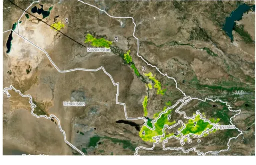
The Syr Darya River, the second largest river in terms of flow volume in Central Asia (catchment area 219,000 km2) is the result of the confluence of two big rivers: the Naryn (59,900 km2) and Karadarya (30,100 km2). Practically all flow of the Syrdarya forms in the mountains and foothills which border the cotton-growing regions:
the Fergana valley, Chrchik-Ahangaran-Keles Irrigation Region, the Hungry Steppe, and the Dalverzyn steppe (Figure 1).
Downstream of Chardara Reservoir the river flow is spent for irrigation needs and evaporation losses from the flood plain. In the 800-km length up to Kazaly only one tributary flows into the Syrdarya – the Arys river (14,000 km2).
River basin The Syr Darya consists of six main parts: the river basin. Naryn – the main tributary of the Syr Darya, collecting water in the Central Tien Shan; Karadarya – the second most important tributary of the Syr Darya; Ferghana Valley, to the center of which more than 100 rivers flow from the surrounding mountains, mostly not reaching the Syr Darya; Western Tien Shan, where the rivers Akhangaran, Chirchik, Keles, Arys come from, which are the right-bank tributaries of the Syr Darya after it leaves the Ferghana Valley;
The southwestern slopes of the Karatau ridge, from which numerous small rivers flow down, not reaching the Syr Darya; flat part of the pool.
The Syr Darya basin is divided into two, from the point of view of economic use, parts: the first is the upper, mountainous zone of runoff formation (the whole of Naryn and the upper Karadarya), where there is practically no fence for irrigation, and the second part is the valley (Syr Darya channel), where the main irrigated land and water withdrawal prevails over the lateral inflow. Irrigated lands are concentrated in the valley regions, primarily in Uzbekistan and Kazakhstan (Sorg et al., 2014).
Data and methods
For analysis land cover/use, we used several land cover products, including MODIS land cover products (MCD12Q1) (https://lpdaac.usgs.gov/dataset_disco- very/modis/), the global surface coverage data (GlobeLand30) (http://www.globeland30.com) and the Climate Change Initiative Land Cover (CCI-LC) project (https://www.esa-landcover-cci.org). Statistical data about irrigation, water withdraw and return water was obtained from the Regional Information System on Water and Land Resources in the Aral Sea Basin (CAWater-IS) (http://www.cawater-info.net) and Regional Research Network “Water in Central Asia”
(CAWa) (http://wuemoca.net/app/).
Results and discussion
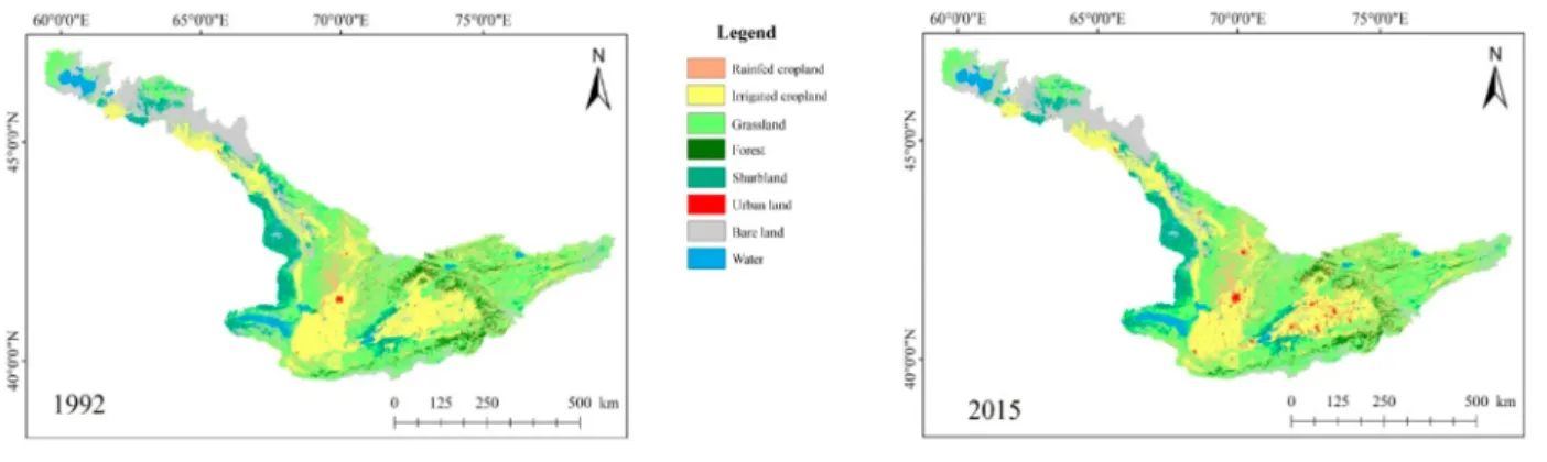
Land cover/land use change in basin
One of the most important signs of human activity is land cover/use change (Figure 2). To determine the land cover/use change induced by human activity, we used the Raster Calculator tool for ArcGIS to analyze the conversion condition between the year 1992 and 2015 land cover/use type.
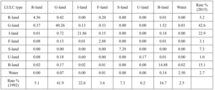
Table 1 describes the conversion percentage of each land cover/use type from 1992 to 2015 in the whole basin. In table 1, the total rates in 1990 and 2015 represent the amounts of each land use type during the first period and the second period, respectively.
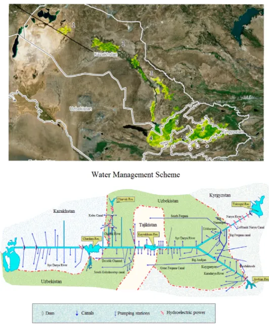
Figure 1 – Irrigation zones of the Syr Darya river basin (1 – Kazaly; 2 – Kyzylorda; 3 – Arys-Turkestan; 4 – Hungry Steppe;
5 – CHAKIR; 6 – Dalverzin and Fergana Irrigation Zones) and Water Management Scheme (Source: CAWa and BWO “Syrdarya”)
Both the bare land and the urban areas increased, whereas the remaining types (e.g., forest, and grassland) decreased. The percentage of urban area
was 0.2 during the first period, and this percentage increased to 1.0 during the second period, indicating rapid urban expansion during the years.
Grassland is the predominant land cover/use type in the study area, respectively accounting for 41.9%
and 42.6 % of the total land area of the river basin in 1992 and 2015, followed by bare land. However, bare land proportion is declining over time. The proportions of the cropland areas in the two periods are 27.7%
and 28.1%, respectively, and they slightly increasing between these periods. Compared with the grassland area in 1992, that in 2015 increases by 2%. From 1992 to 2015, the land area for construction exhibits the highest interannual dynamic change. The forestland
Figure 2 – LULC types in the Syr Darya River Basin in 1995 and 2015
area decreases by 0.5%, and the water area increases by 0.2%. According to some studies, a significant increase in precipitation could have affected the increase in grassland and water area. Over the past 17 years, the area of water bodies and wetlands in five countries of Central Asia has increased significantly (especially the areas surrounding the Aral Sea and Lake Balkhash). In addition, with a decrease in the drought index, pasture areas in southern Central Asia and natural vegetation increased significantly (Hu and Hu, 2019).
Table 1 – The conversion percentage (%) of each land use type from 1992 to 2015
LULC type R-land G-land I-land F-land S-land U-land B-land Water Rate %
(2015)
R-land 4.56 0.42 0.00 0.20 0.00 0.00 0.01 0.00 5.2
G-land 0.37 40.26 0.13 0.33 0.00 0.00 1.52 0.01 42.6
I-land 0.01 0.72 21.86 0.15 0.00 0.00 0.18 0.00 22.9
F-land 0.08 0.13 0.01 2.88 0.00 0.00 0.01 0.00 3.1
S-land 0.00 0.00 0.00 0.00 7.29 0.00 0.00 0.00 7.3
U-land 0.08 0.18 0.60 0.00 0.00 0.17 0.01 0.00 1.0
B-land 0.02 0.17 0.02 0.01 0.00 0.00 14.88 0.02 15.1
Water 0.00 0.07 0.00 0.01 0.00 0.00 0.14 2.50 2.7
Rate %
(1992) 5.1 41.9 22.6 3.6 7.3 0.2 16.7 2.5
R-land-Rainfed Cropland; G-land-Grassland; I-land Irrigated-Cropland; F-land-Forest; Sh-land-Shurbland; U-land- Urban land;
B-land-Bare land
Water construction in the basin
The Syr Darya River Basin, the main cotton base, belongs to ancient irrigation areas. In 1913, 1073 thousand ha were irrigated in the Syr Darya river basin (up to the Chardara); including 743 thousand hectares in the Ferghana Valley, 219 thousand hectares in the CHAKIR, 50 thousand in the Hungry Steppe and 7 thousand hectares in Dalverzin (Chembarisov, 1988; Micklin and Williams, 1996).
In the period 1933-1938, construction of large hydraulic structures on the Karadarya River (Kampyrravat Dam) and on the Chirchik River (Gazalkent Dam) began (Rubinova, 1979). This allowed us to switch to planned water use in the basins of these two largest rivers. At the same time, work was underway to increase the water availability of low-water systems by connecting them to high- water ones. However, a radical reorganization of the water economy of the Syr Darya river basin,
which allowed significantly expanding the size of irrigated lands and increasing their water supply, began in 1938-1940, when the Northern, Southern and Big Ferghana canals were built (Table 2). In the same years, the construction of the Sarysui, Fayzyabad, Rishtanbogdad collectors was started.
In 1950, one of the largest collectors in the Ferghana Valley – North Bogdad entered service. Also, widely irrigation and drainage construction took place in the Hungry and Dalverzinsky steppes.
The construction of the largest hydroelectric facility on the Naryn River and a number of pumping stations on the Syr Darya River made it possible to significantly increase the size of the lands irrigated from these sources. As a result of this, the areas that feed from the Karadarya River and the side tributaries of the Syr Darya River within the Fergana Valley have somewhat decreased, and their water supply has increased (Antipova et al., 2002).
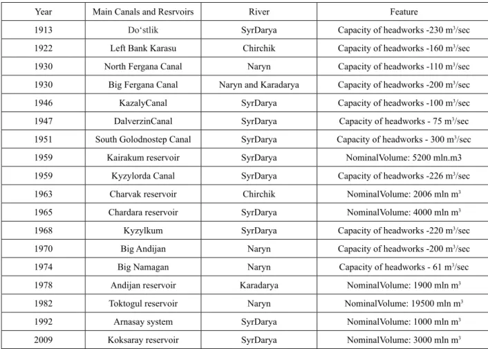
Table 2 – Main Water construction in the Syr Darya basin
Year Main Canals and Resrvoirs River Feature
1913 Do‘stlik SyrDarya Capacity of headworks -230 m3/sec
1922 Left Bank Karasu Chirchik Capacity of headworks -160 m3/sec
1930 North Fergana Canal Naryn Capacity of headworks -110 m3/sec
1930 Big Fergana Canal Naryn and Karadarya Capacity of headworks -200 m3/sec
1946 KazalyCanal SyrDarya Capacity of headworks -100 m3/sec
1947 DalverzinCanal SyrDarya Capacity of headworks - 75 m3/sec
1951 South Golodnostep Canal SyrDarya Capacity of headworks - 300 m3/sec
1959 Kairakum reservoir SyrDarya NominalVolume: 5200 mln.m3
1959 Kyzylorda Canal SyrDarya Capacity of headworks -226 m3/sec
1963 Charvak reservoir Chirchik NominalVolume: 2006 mln m3
1965 Chardara reservoir SyrDarya NominalVolume: 4000 mln m3
1968 Kyzylkum SyrDarya Capacity of headworks -220 m3/sec
1970 Big Andijan Naryn Capacity of headworks -200 m3/sec
1974 Big Namagan Naryn Capacity of headworks - 61 m3/sec
1978 Andijan reservoir Karadarya NominalVolume: 1900 mln m3
1982 Toktogul reservoir Naryn NominalVolume: 19500 mln m3
1992 Arnasay system SyrDarya NominalVolume: 1000 mln m3
2009 Koksaray reservoir SyrDarya NominalVolume: 3000 mln m3
The construction of the Kayrakkum, Chardara,
Charvak and other reservoirs in 1950-1970 made it possible to further expand irrigated areas and increase their water availability. The Toktogul and
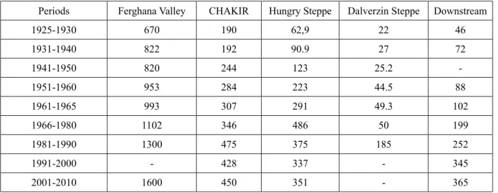
Andijan and a number of smaller reservoirs on the tributaries of the Syr Darya River serve the same purpose. The increase in irrigated areas within the irrigation zone of the river basin is illustrated in the table 3. According to these data, in the first half of the 1970s, the irrigated area in the upper part of the basin (Fergana and ChAKIR) increased by 1.6, relative to the beginning of the 1930s, in the middle course by 5.6 and in the lower by 3.3 times.
The increase in water intake from rivers and the
construction of reservoirs significantly changed their river regime, particularly in the lower reaches. In connection with the increase in the flow of collector-drainage (return) water into the rivers in the autumn months, water consumption in them is somewhat increased. In general, the hydrological conditions of the river basin deteriorated with the development of irrigation, especially in the downstream of the river (Chembarisov et al., 2013).
Table 3 – The size of irrigated areas in the irrigation zone of the Syr Darya river basin, thousand ha
Periods Ferghana Valley CHAKIR Hungry Steppe Dalverzin Steppe Downstream
1925-1930 670 190 62,9 22 46
1931-1940 822 192 90.9 27 72
1941-1950 820 244 123 25.2 -
1951-1960 953 284 223 44.5 88
1961-1965 993 307 291 49.3 102
1966-1980 1102 346 486 50 199
1981-1990 1300 475 375 185 252
1991-2000 - 428 337 - 345
2001-2010 1600 450 351 - 365
Irrigation and irrigation and drainage construction in the Syrdarya river basin has turned it into a complex water management system that substantially transforms within its limits the river flow coming from the formation area.
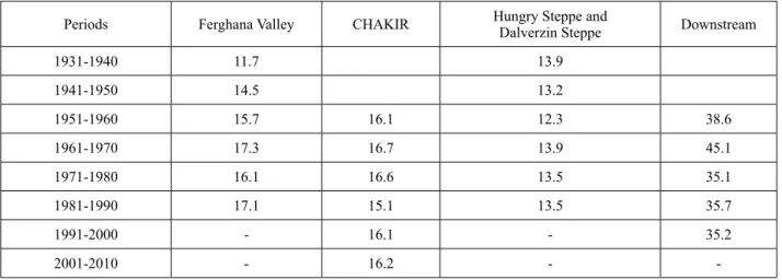
Irrigation and Water withdraw in the basin The increase in the size of the irrigated area (Table 3) was accompanied by an increase in its water supply. Both of these processes led to an increase in weaning from the river (Table 4, Figure 3). The lack of information on water withdrawal at the end of the 1930s in a number of irrigation areas limited the information content of table 4. However, the information provided in it allows us to appreciate how substantially the withdrawal of runoff from the rivers of the basin has increased.
The Syr Darya River and its basin belong to the areas of ancient irrigation. In 1913, in the upper and middle reaches of the Syr Darya river basin, 1073 thousand hectares were irrigated. The following years, the irrigation area only increased
(Table 3). Its water availability has also increased (Rubinova, 1979). These processes led to an increase in weaning flow from the Syr Darya river.
The Syr Darya basin is characterized by greater pressure on water resources. Even in the 1930s, losses amounted to more than 60% of the flow.
The influx of water into the sea began to stop in the mid-1970s. The use of irrigated agriculture is relatively higher here than in the Amudarya basin:
at present it is 85%. At the same time, the share of natural losses decreased from 50% of total losses to 3%. Water supply of the population and industry plays an important role in the Syr Darya basin and accounts for more than 10% of the total losses (Belyaev, 1995).
The largest water consumer is irrigated agriculture. The largest irrigated area is located in the Fergana Valley; it is also significant in the Hungry Steppe and the Tashkent oasis. In the lower reaches of the river, the largest irrigated tracts are Arys-Turkestan and Kyzylorda. Within Kyrgyzstan, smaller areas are irrigated (Chembarisov et al., 2013).
Table 4 – Specific withdrawal from surface water to irrigation zone of the river basin Syrdarya, thousand m3/ha
Periods Ferghana Valley CHAKIR Hungry Steppe and
Dalverzin Steppe Downstream
1931-1940 11.7 13.9
1941-1950 14.5 13.2
1951-1960 15.7 16.1 12.3 38.6
1961-1970 17.3 16.7 13.9 45.1
1971-1980 16.1 16.6 13.5 35.1
1981-1990 17.1 15.1 13.5 35.7
1991-2000 - 16.1 - 35.2
2001-2010 - 16.2 - -
From 1950 to 2012, the irrigated area in the river basin increased by 2 times and reached 10.14 million hectares. During this period, the area of irrigated land in the region increased by 94%; over the decades, these increases were: 1950-1965. – by 12%; 1965-1975 by 20%; 1975-1985 – by 44%
and 1985-1995 – by 25%; this is an overload for ecological systems (Mustafaev and Kozykeeva, 2012). Therefore, environmental degradation of the environment in the Aral Sea Basin is a direct consequence of the intensive expansion of irrigated areas in the river basin.
The dynamics of the expansion of irrigated land from 1950 to 2012 shows that the pace of the introduction of new areas in the region was very high. Every year, from 1.2 to 2.8% of new lands were introduced into economic circulation, and this indicator in Tajikistan and Uzbekistan reached a record level of 3.4 and 3.3% (Mustafaev and Kozykeeva, 2012). In the Syr Darya river basin, between 1976 and 1980, irrigated lands of more than 280 thousand hectares were cultivated, in 1981–
1985 and 1986–1990 over 180 thousand hectares.
According to the data of BWO «Syr Darya» and DB CAREWIB, the total water intake in the Syr Darya river basin was approximately 50,000 million m3 on average in 1980–1990, of which 38,000 million m3 was for irrigation. This means that more than 70%
of the total water intake was taken for irrigation. In the period 1990-2000 this figure was 45,000 million m3, of which about 32,000 million m3were taken for irrigation. At present, it is about 41,000 million m3, of which 31,000 million m3 for irrigation. This is 75% of the total water intake. A large amount of water intake from the rivers of the Syr Darya basin is passed in Kazakhstan and Uzbekistan. They take 80% of the
total water intake. Also, irrigation water intake is very high in these countries.
For the Kyrgyz Republic and the Republic of Kazakhstan, more than 90% of water intake goes to irrigation. For the Republic of Tajikistan, the water intake for irrigation is more than 70%, for the Republic of Uzbekistan, 60% (Figure 3).
As can be seen from Figure 3.4, the development of agricultural lands in the Syr Darya River Basin has a great influence, first of all, on the nature of the use of water resources of the basin. It is also clear that the river flow has decreased due to an increase in irrigation and water intake areas. In dynamics, it is clear that since the 1970s, the area of irrigated land has rapidly increased, reaching its peak in the period 1980-1990. Some of the reduction in irrigated area is due to the fact that land degradation processes in the region and the general economic downturn in agriculture in 1990-2000. Although, after independence, the area of irrigated land in the Central Asian states did not change much (with the exception of Turkmenistan, where the area of irrigated land increased in 1995-1996).
Over the past 20 years, the specific water consumption in the basin has gradually decreased as a result of water withdrawal limits set by intergovernmental organizations (1980 – 18,200 m3/ ha, 1990 – 14,600 m3/ha, 1995 – 12 200 m3/ha and 1998 – 12,400 m3/ha)
A number of natural low-water years observed in recent years (2000–2001, 2010–2011), as well as anthropogenic changes in the flow of the Syr Darya River, cause significant damage to the national economy, including the agricultural complex. Due to drought and lack of irrigation water, rural residents also experience great difficulties and losses.