This guide on "Simplified Keys to Soil Series" has been developed for easier field identification of soils. It contains the different colors, textures, pH and other observable characteristics of the most common soils of Cagayan and includes four simple steps to identify the soil range right in the field. In the Philippines, the project “Simplifying the Philippine Soil Series for Rice and Maize” began in 2005 under the Nutrient Management Support System (NuMASS) to provide management recommendations for soils identified in the field.
We thank the farmers, agricultural technologists and municipal and provincial agricultural experts who helped us validate the soil series. The "Simplified Keys to Soil Range" is a tool for identifying soil ranges in the field by following simple steps for the use of farmers, extension workers, agricultural technologists, researchers and other stakeholders. Selection of knowledge and technology can also be easy and effective in identifying soil ranges.
Using only five basic soil properties (colour, texture, pH, coarse fragments and stains) at a depth of 30-50 cm and following the simple steps given, the soil series can be identified in the field. Use the simplified soil key series guide and compare all soil properties starting from color until the soil name is identified.
Dark/Grayish Brown
Texture: Clay
Yellowish Red
Yellowish Brown
Reddish Brown
Gray/Olive Gray
Texture: Heavy clay
Texture: Clay loam/Clay/Sandy loam
Black
Alaminos
Bago
Bantay
Barcelona
Bigaa
Bolinao
Buguey
Indicators of soil fertility Inherent fertility Low to moderate soil pH Slightly acidic (5.5-6.5) Organic matter Low to moderate Phosphorus (P) Low.
Carig
Faraon
Soil fertility indicators Inherent fertility Low to moderate soil pH Slightly acidic (5.0-6.0) Organic matter Low.
Ilagan
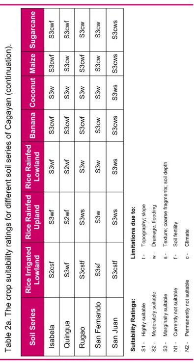
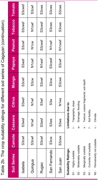
Isabela
Quingua
Rugao
San Fernando
Soil Fertility Indicators Inherent Fertility Moderate to high soil pH Slightly acidic. 5.5-6.2) Organic matter Low phosphorus (P) High potassium (K) Moderate nutrient retention.
San Juan
San Manuel
Soil Fertility Indicators Inherent Fertility Moderate to high soil pH Slightly acidic to neutral. 5.5-7.2) Organic matter Low phosphorus (P) High potassium (K) Moderate nutrient retention. Soil pH Slightly acidic to neutral (6.5-7.5) Organic matter Moderate Phosphorus (P) Moderate to high Potassium (K) Moderate to high Nutrient retention.
Sta. Rita
Toran
Umingan
Soil fertility indicators Natural fertility Moderate to high Soil pH Slightly acid to neutral. 5.5-7.5) Organic matter Low phosphorus (P) Moderate potassium (K) Low to moderate nutrient retention.
Zaragosa
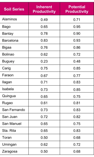
Soil productivity is the quality that summarizes the soil's potential to produce plants or sequences of plants under defined sets of management practices. It is also a synthesis of conditions for soil fertility, water management, plant species, soil, pest control and physical environment (Bainroth, 1978: Badayos, 1990). Economically, it is a measure of the amount of inputs of production factors required to correct soil limitation(s) to achieve a certain level of production.
The Soil Productivity Index is used to make comparisons between soils; categorized into inherent and potential. Inherent productivity is the natural ability of the soil to produce a given yield; potential refers to its ability to produce yield after correctable soil limitations have been remedied. In economics, the predicted intrinsic yield is calculated by multiplying the intrinsic index by the maximum potential yield (MPY) of rice; predicted maximum possible yield is calculated by multiplying the potential index by the MPY.
For example, the MPY in the dry season is 8 tons/ha, and the natural and potential productivity estimates for the Alaminos series are 0.49 and 0.71, respectively. The predicted natural and potential yields of rice in the Alaminos lands are then 3.92 and 5.68 tons/ha.
Soil Series Inherent Productivity
CROP
APPENDIX 1. STEPS TO IDENTIFY SOIL SERIES
1 Soil sampling
2 Color determination
APPENDIX 2. THE PALAYCHECK ® SYSTEM
- Used high-quality seeds of a recommended
- No high and low soil spots after final level-
- Practiced synchronous planting after a fallow
- Sufficient number of healthy seedlings
- Sufficient nutrients at tillering to early panicle
- Avoided excessive wa- ter or drought stress
- No significant yield loss due to pests
- Cut and threshed the crop at the right time
Glossary
Salinity – the content of salt or dissolved salt (such as sodium chloride, magnesium and calcium sulphates and bicarbonates) in the soil. Soil drainage – refers to the frequency and duration of periods of soil saturation. Soil family - a group of soils within a subgroup with similar physical and chemical properties that affect their responses to handling and manipulation for use.
Soil profile - includes a collection of all genetic horizons, natural organic layers on the surface, and parent material or other layers below the salt that influence the formation and behavior of the soil. Soil Series - A group of soils with similar profiles that have developed from similar parent materials under comparable climatic and vegetation conditions. Soil taxonomy - hierarchies of classes that allow understanding of the relationships between soils and also between soils and the factors responsible for their character.
Soil texture- refers to the relative proportions of the different size groups of individual soil grains in a mass of soil. Specifically, it refers to the proportions of clay, silt and sand below 2 millimeters in diameter. Soil water retention – the ability of soil to retain water to provide a continuous supply of water to plants between periods of recharge (infiltration) to enable their continued growth and survival.
The width (average or average width and maximum width) of the cracks at the surface is given in centimeters. Tuff – a rock composed of the finer forms of volcanic detritus, usually fused together by heat. Workability/Slope – the ease of cultivating the soil in terms of its structure, texture, presence of coarse fragments and relief.
Soil textural classes
We are grateful to the Bureau of Soils and Water Management (BSWM) for the secondary soil data used in this guide.