Establishment and Operation of a Regional System of Fisheries Refugia in the South China Sea and Gulf of Thailand
CORON
FISHERIES REFUGIA MANAGEMENT PLAN
MUNICIPALITY OF CORON PROVINCE OF PALAWAN, PHILIPPINES
LILIAN C. GARCIA
NATIONAL FISHERIES RESEARCH AND DEVELOPMENT INSTITUTE (NFRDI) And
JOEREN S. YLEANA
BUREAU OF FISHERIES AND AQUATIC RESOURCES (BFAR)
SOUTHEAST ASIAN FISHERIES DEVELOPMENT CENTER TRAINING DEPARTMENT
SEAFDEC-UNEP-GEF-PHILIPPINES: REP-PH84
First published in Phrasamutchedi, Samut Prakan, Thailand in December 2022 by the SEAFDEC-UNEP-GEF Fisheries Refugia Project, Training Department of the Southeast Asian Fisheries Development Center Copyright © 2022, SEAFDEC-UNEP-GEF Fisheries Refugia Project
This publication may be reproduced in whole or in part and in any form for educational or non-profit purposes without special permission from the copyright holder provided acknowledgement of the source is made. The SEAFDEC-UNEP-GEF Fisheries Refugia Project would appreciate receiving a copy of any publication that uses this publication as a source.
No use of this publication may be made for resale or for any other commercial purpose without prior permission in writing from the SEAFDEC Secretary-General at.
Southeast Asian Fisheries Development Center Training Department
P.O.Box 97, Phrasamutchedi, Samut Prakan, Thailand Tel: (66) 2 425 6100
Fax: (66) 2 425 6110
https://fisheries-refugia.org and https://seafdec.or.th
DISCLAIMER:
The contents of this report do not necessarily reflect the views and policies of the Southeast Asian Fisheries Development Center, the United Nations Environment Programme, and the Global Environment Facility.
For citation purposes this document may be cited as:
Municipality of Coron/Palawan, Garcia, L.C. and Yleana, J., 2022. Establishment and Operation of a Regional System of Fisheries Refugia in the South China Sea and Gulf of Thailand, Coron Fisheries Refugia Management Plan. Southeast Asian Fisheries Development Center, Training Department, Samut Prakan, Thailand; FR/REP/PH84, 50 p.
Southeast Asian Fisheries
Development Center United Nations
Environment Programme Global Environment Facility
CORON FISHERIES REFUGIA MANAGEMENT PLAN
MUNICIPALITY OF CORON
PROVINCE OF PALAWAN
CHAPTER 1. INTRODUCTION
Rationale
The establishment of the Fisheries Refugia will enable the local government units to manage their fisheries and marine resources as well as the coastal habitats sustainably. Most, if not all of the issues and problems that beset the fisheries and coastal management will be addressed through the broader perspective of ecological, human and governance aspects of management.
Scope of the Plan
The Plan will be covering the contiguous coastal barangays identified in Coron, Palawan. The management of these areas will involve the partnerships among and between the LGUs, the academe, the private sector, the fishers and others who are either direct or indirect beneficiaries.
Legal Basis
The Fisheries Code and the Local Government Code are the two major laws that promote the establishment of the Fisheries Refugia. There are other environmental laws that also ensure the protection of fisheries and marine resources. Specifically, the LGUs are mandated to enact fisheries ordinances that will protect the resources in their areas of jurisdiction.
Vision
Accelerate growth of fisheries industry output through use of high technology, increase productivity as well as targeting the export market by increasing local investment and foreign direct investment
A responsible community enjoying and sharing justly the bounty of sustainably-managed marine resources and environment governed by the rule of laws.
Mission
Accelerate growth of fisheries industry output through use of high technology, increase productivity as well as targeting the export market by increasing local investment and foreign direct investment.
Implement the spatial & temporal management of the marine fisheries resources and protect, conserve, manage the marine environment to accelerate the sustainable growth of fisheries industry productivity towards an economic growth of Coron Municipality.
Goals
A. Ecological Well-Being Component
• Sustained and coherent marine habitat and fisheries management
B. Human Well-Being Component
• Empowered and better quality of life of the coastal municipal fisherfolks in particular and the community in general
C. Good Governance Component
• Improved, sustained and rational implementation of the coastal policies, regulations and laws.
Objectives
A. Ecological Well-Being Component A.1 Fisheries Management
1. To establish and manage the Fisheries refugia
2. To implement spatial and temporal close fishing during the critical stages in the life cycle of fish (spawning and juvenile stages)
3. To set guidelines in the construction and operation of fish corrals, marine- culture and other fishing activities in the refugia site and adjacent waters 4. To establish fishery monitoring mechanism on the enforcement of
environmental and fishery laws A.2 Coastal Habitat Management
1. To implement the Mangrove forest management under the Community-Based Forest Management (CBFM) framework
2. To protect and properly manage the seagrass meadows and algal beds 3. To protect and conserve the corals and reefs
A.3 Coastal Zoning and Shoreline Management
1. Designate Zones for specific uses (for strict protection, rehabilitation, aquaculture, tourism, trade and navigation, etc.) designated
2. Fishing activities and use of gear in every zone regulated 3. Coastal setbacks for all development implemented A.4 Waste Management
1. To strictly implement the Ecological Solid Waste Management Code of the Municipality of Coron.
2. To strictly enforce the Environmental Compliance Certificate (ECC) requirements issued by the Environmental Management Bureau-DENR, specifically on the required installation of wastewater treatment facilities by fishery-related and similar industries situated along coastal areas.
A.5 Climate Change Mitigation, Adaptation and Disaster Risk Reduction and Management
SEAFDEC-UNEP-GEF-PHILIPPINES: REP-PH84 1. Condition of marine habitat, fisheries and community determined.
2. Damaged critical coastal and marine habitats rehabilitated.
3. Vulnerable critical coastal and marine habitats protected and conserved.
4. Environment friendly and green technology adopted and promoted in the municipality.
5. Climate change adaptive and disaster resilient communities established.
B. Human Well-Being
B.1 Livelihood & Enterprise Development
1. Environmentally-sound alternative livelihood identified and implemented 2. Coastal aquaculture sustainably managed
3. Seaweeds farming
B.2 Coastal Eco-Tourism Development
1. Island hopping and dive tour activities regulated 2. Baywalk park established and managed
C. Good Governance
C.1 Legal Arrangement and Institutional Development
1. Integrated Coastal and Fisheries Resource Management (ICFRM) in the municipality institutionalized
2. Integrated Coastal and Fisheries Resource Management (ICFRM) Plan institutionalized
3. Fund for the plan provided
4. People’s organization (POs) strengthened
C.2 Information, Education and Communication Campaign
1. Tri-media IEC materials on ecosystem approach in coastal and fisheries management designed and developed
2. Community awareness/information drive on ecosystem approach in coastal and fisheries management conducted
3. Information on ecosystem approach in coastal and fisheries management promoted and disseminated
Functions, Roles and Responsibilities of the Local Government Unit and partners
● Managing the fisheries resources in accordance with the Fisheries Code, the Local Government Code and acts, regulations enacted by the local government.
● Fisheries stock assessment, planning and management.
● Conservation of fisheries resources
● Development of rational and sustainable aquaculture industry
● Product development in seafood
● Implementation of food safety and quality control programme in the seafood processing industry
● Providing technical and support services to the fisheries industry
CHAPTER 2. PROFILE OF THE FISHERIES REFUGIA
Coron Fisheries Refugia
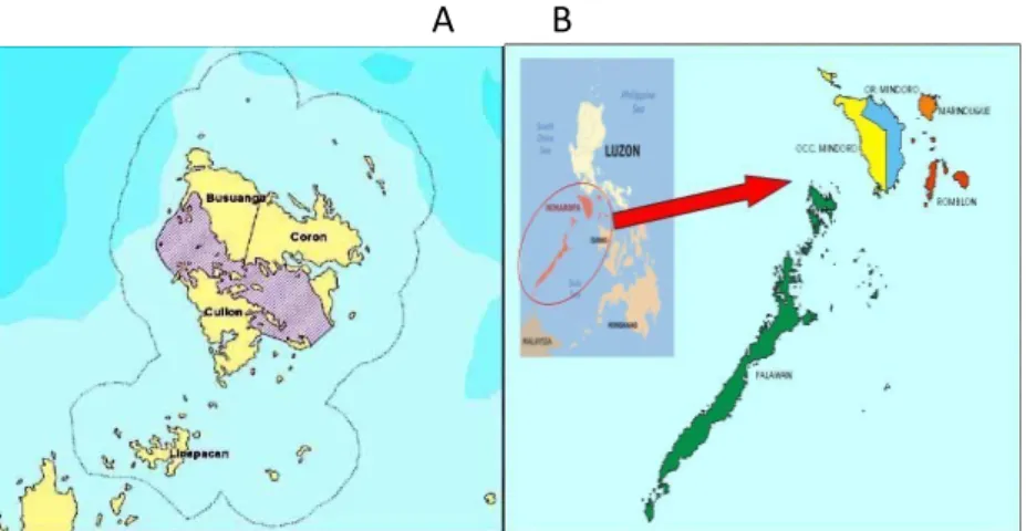
The fish refugia site is located in the Calamianes Group of Islands or simply known as Calamianes (Figure 1-A). The specific site is in the municipality of Coron, Palawan, one of the four municipalities in the Calamianes Group of Islands. The three other municipalities are Busuanga, Culion and Linapacan. Palawan is under the Philippine Administrative Region referred to as MIMAROPA which stands for the four provinces under this region namely: the two provinces of Mindoro (MI) Mindoro Oriental and Mindoro Occidental , Marinduque (MA), Romblon (RO) and (PA) Palawan (Figure 1-B). Palawan is also the largest province in the Philippines having a total land area of 14,649.73 square kilometers or 5,656.29 square miles, and for geographical purposes to include Puerto Princesa City the total land area is 17,030.75 square kilometers or 6,575.61 square miles.
A B
Source: A. USIAD FISH Project, B. Zamboanga.com
Figure 1. A. Map of the Calamianes Group of Islands, B. Map of the MIMAROPA Region History
The name Coron, meaning “pot” in Cuyonon was given by Don Nicolas Manlavi y Ledesma, a native of Cuyo, who migrated to and settled in Banuang Daan, a barangay about 10 kilometers away from the town proper of Coron. In another version, the Tagbanuas named the place
“Coron” meaning enclosed since the place is almost bounded by tall mountains on its three sides. That place is now known as Banuang Daan in Coron Island.
Two groups pioneered inhabitation in Coron. First came the Tagbanuas, a sea-faring group who lived on fishing and crude agriculture. The Calamianes, a group who descended from the first wave of Malay immigrants who graced the Philippine lands between 20 BC and 100 AD came to Coron too. The Tagbanuas and the Calamianes were the ancestors of the Igorots and Bontocs of the Mountain Province. (FLUP, 2014) Intermarriages of immigrants from Visayas, Cuyo, Agutyo, Cagayancillo and other regions caused Calamianens to lose their tribal identity.
During the last centuries of the Spanish regime, the immigrants who settled in the Calamian group of Islands were the Sandovals and Rodriguezes from Culion, the Vincuas from
SEAFDEC-UNEP-GEF-PHILIPPINES: REP-PH84 Cagayancillo in Coron Island and Don Nicolas Manlavi y Ledesma who settled in the mainland of Busuanga. In 1749, Pedro Vincua from Cagayancillo led in establishing an organized government through an authority of the Governor General to make Coron a “visita” under the jurisdiction of Culion, which was the “matria” at that time. This was officially named Peñon de Coron and this existed for more than fifty years.
In 1902, Coron was registered as a town with Don Vicente Sandoval as their first Alcalde Mayor. The name of the municipality was then changed from Peñon de Coron to Coron. The early 20th century brought about different industries to Coron. In 1939, Coron, being a place with mountains rich with mineral reserves, experienced a mining boom until the outbreak of World War II in 1942. The Japanese occupied the mining camps in July 1942 and resumed manganese mining then. Coron was liberated from the Japanese forces in 1945. On the other hand, deep sea fishing flourished in Coron in 1947. The population increased due to the opportunities of the municipality. People from all over the country worked either as fishermen or miners.
Today, the Municipality of Coron is a premier tourist destination for locals and foreigners for its breathtaking views and scenic places like the beautiful white sand beaches, marine parks, preserved wreckage of war, dive sites and coral reefs coupled with excellent services and accommodations,
The name Coron was given by Don Nicolas Manlave Y Ledesma, a native of Cuyo. According to him, the bay fronting Barangay Banuang Daan, their first settlement, looked like an earthen pot. Coron is a Cuyonon term for pot.
The first inhabitants of Coron were the Tagbanuas. They form part of the second wave of Indonesians who migrated to this country some 5000 years ago.
The second tribe to inhabit the place was the Calamianens. They descended from the first wave of Malay immigrants who came to the Philippines between 200 B.C. and 100 A.D. They are the ancestors of Igorots and Bontocs (Coron Municipal 2004 Profile).
Municipal Profile
● Geographical location
The Calamianes group of Islands is located in the Northern Islands of the province of Palawan.
Coron is located in the largest island of the Calamianes group of islands called Busuanga Island and occupies two thirds of the eastern part of Busuanga Island. The geographical coordinates of Coron are 11 60 North, 120 12 East (Fig 1).
Coron’s topography is made-up of mountains with steep cliffs formation structure. 70% of the wedge-shaped mountains is dominated by steep cliffs and Karst rock formations made of Permian limestone of Jurassic origin. The 30% of the land is made up of 5% flat land and 25%
rolling hills.
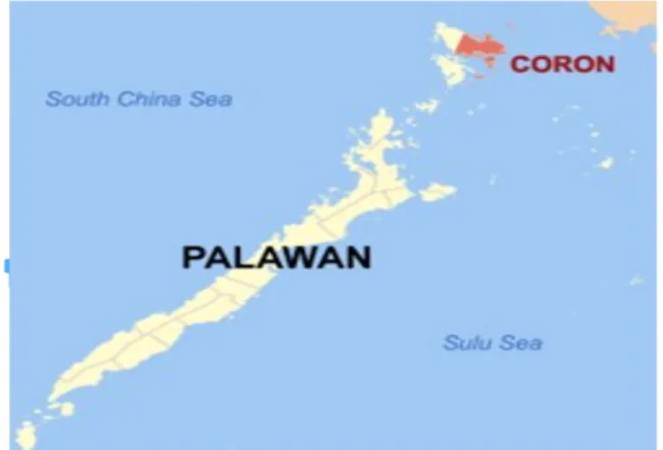
Figure 2. Map of the Palawan with Coron highlighted.
● Site Information Geography
The municipality of Coron occupies a big portion of Busuanga Island and more or less 50 minor islets. Coron is about 20 Kilometers or 12 miles long from north to south. The broadest point of the land is 9 kilometers or 5.6 miles. On the Western part of Busuanga Island is the Municipality of Busuanga which occupies a third of the Island. The municipality has a total land area of 689.10 square kilometers or 266.06 square miles. This land area is 4.70% of the total land area of Palawan. Coron has 23 barangays (Barrio or village).
Coron’s topography is made-up of mountains with steep cliffs formation structure. About 70%
of the wedge-shaped mountains is dominated by steep cliffs and Karst rock formations made of Permian limestone of Jurassic origin. The 30% of the land is made up of 5% flat land and 25% rolling hills.
History, population, socio economy
The Tagbanuas, Calamiananen and Cuyonon were the original inhabitants of the Calamianes Islands. The first permanent Spanish settlement in Calamianes Island was established in Culion. Around 1670, the Spaniards built a fort and church in Culion as part of the defenses against the Muslim attacks. The settlement also attracted migrants to the Calamianes Islands.
One of the migrants to Culion was the Sandoval clan from Jaro, Iloilo. A migrant named Claudio Sandoval later married Don Nicolas Manlavi’s only daughter Evarista. The Sandoval clan came from this wedding. Don Nicolas Manlavi, a Cuyonon who worked for several years in the Spanish Galleon established the first settlement in Coron Island. The first settlement in Coron was in Banuang Lague (old town) now called Banuang Daan in Coron Island. The town proper was moved to Maquinit and then the town proper was established in the present-day Bancuang in Barangay 5.
Dean Worcester, an American naturalist, traveled to the Calamianes to collect specimens and stayed in Culion for a while in the late 1890s. He was appointed as Secretary of the Interior of the First Philippine Commission in the early 1900s. He recommended Culion as the Philippine Leper Colony. Because of this event the Sandoval clan were forced to transfer to the different
SEAFDEC-UNEP-GEF-PHILIPPINES: REP-PH84 barrios of what is now Coron and Busuanga in 1900. The family of Claudio Sandoval settled in Coron town and the other members of the Sandoval clan settled in the present Barangay Bintuan, Salvacion, Concepcion and Old Busuanga.
In 1950, Busuanga town was created. The barrios of Concepcion, Salvacion, Busuanga, New Busuanga, Buluang, Quezon, Calawit, and Cheey were transferred from Coron to the created town of Busuanga. The town of Linapacan was created in 1954 from the islands of Linapacan, Cabunlaoan, Niangalao, Decabayotot, Calibangbangan, Pical and Barangonan which used to be part of Coron town.
The total population of the municipality in the 2015 Census was 51,803 which represents 6.10% of the total population of Palawan province. The population density of Coron based on the 2015 census was 75 inhabitants per square kilometer or 195 inhabitants per square mile.
The center of Coron is in Poblacion barangays 1 to 6 where the Municipal Building, the Municipal Legislative Building and the Judiciary Hall are located as well as the main population of the town.
Coron is a first-class municipality having an annual regular revenue for the fiscal year 2016 of P201,320,832. The main economic activity in Coron is fishing and tourism. Before the 1970s, during the Japanese occupation manganese mining was the main economic activity in Coron particularly in Barangay San Nicolas. The fishing industry flourished in the 1970s until the 1990s. Then the industry declined due to rampant illegal fishing and sodium cyanide fishing.
The rattan industry was also a good source of income for the local residents during those years. However, the industry gradually declined during the same period due to the subsequent decline of the raw material. At present only a few families are engaged in this industry.
Tourism is currently the top industry in Coron and a major source of income. This is mainly because of the natural beauty of the local islands, beaches, amazing dive sites and natural tourist attractions. Several sunken Japanese warships attract local and foreign divers in exploring the sunken ships located between 10 to 40 meters deep near Coron Island. The site is listed in the Forbes Traveler Magazine’s top 10 best diving sites in the world. And recently it became the number one site in the world.
The Coron Island Natural Biotic Area in the municipality of Coron is listed in the natural category of the UNESCO World Heritage Tentative List.
Important coastal habitats in the area
Mangrove
The total mangrove area of Coron is about 2,690.80 hectares where 25.55% of mangrove are found in Barangay Bintuan. There are 18 mangrove species recorded in Coron and 20 associate mangroves species observed to exist in the municipality. The following are the most
widely distributed mangroves species in Coron out of the 14 families and 27 genera documented in Coron: Rhizophora errulate, Rhizophora stylosa, Xylocarpus granatum, Bruguiera gymnorrhiza, Bruguiera cylindricam, Lumnitzera littorea, Ceriops tagal, Ceriops decandra, and Heritiera littorea. The five abundant species observed are Rhizophora errulate, Rhizophora errulate, Xylocarpus granatum, Bruguiera gymnorrhiza and Rhirozphora stylosa.
Coral Reef
Coron has a coral reef area of 8,269.45 distributed all over the whole municipality. Barangay Bulalacao has the highest number of corals having a total of 2,861.68 hectares or 34.61% of the total corals observed and recorded in the entire municipality. However, there are also coastal barangays where you cannot find corals thriving in the area. These are the barangays located in the town proper or Poblacion namely; Barangay I, II, III and IV.
Reports have shown that there are 47 families of reef and reef-associated fish species comprising 342 species recorded present all over the marine waters of Coron. Some of the families found in Coron are: Siganidae (rabbitfish), Lutjanidae (snapper), Lethrinidae (emperor breams), Engraulidae (anchovy), Holocentridae (soldier fish), Haemulidae (sweetlips), Labridae (wrasse), Carangidae (Jacks), Tetraodontidae (puffer fish), Monacanthidae (filefish), Apogonidae (cardinal fish), Scaridae (parrot fish) and Pomacentridae (damselfish), Myliobatidae (eagle ray), Chaetodontidae (butterfly fish).
Seagrass Communities
Coron has high density of seagrass and is home to nine species of seagrass. These are the following: Enhalus acoroides, Thalassia hemprichii, Halophila ovalis, Syringodium isoetifolium, Halodule pinifolia, Cymodocea rotundata, Cymodocea errulate, Holodule unniervis, and Halophila sp. (minor or decipiens). The highest number of seagrass concentration is in Barangay Bulalacao while the highest number of limited seagrass present is observed in Barangay Bintuan covering a total of about 133.8 hectares.
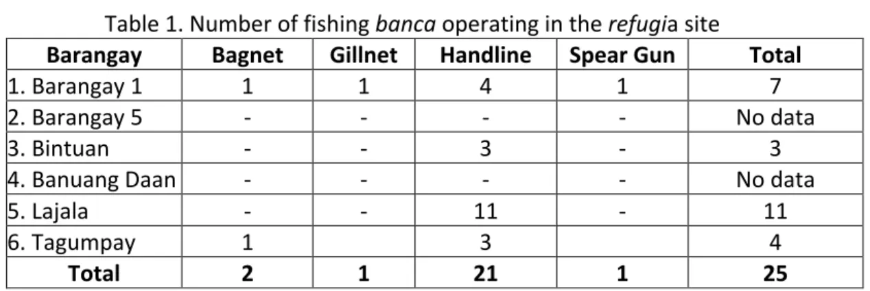
Number and types of fishing vessels operating in the refugia sites
Table 1. Number of fishing banca operating in the refugia site
Barangay Bagnet Gillnet Handline Spear Gun Total
1. Barangay 1 1 1 4 1 7
2. Barangay 5 - - - - No data
3. Bintuan - - 3 - 3
4. Banuang Daan - - - - No data
5. Lajala - - 11 - 11
6. Tagumpay 1 3 4
Total 2 1 21 1 25
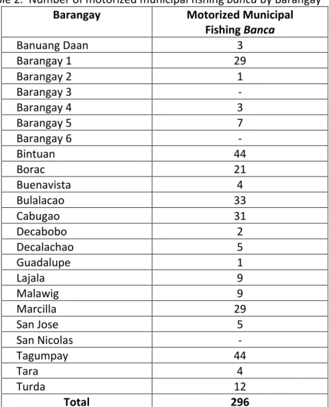
Table 2. Number of motorized municipal fishing banca by Barangay Barangay Motorized Municipal
Fishing Banca
Banuang Daan 3
Barangay 1 29
Barangay 2 1
Barangay 3 -
Barangay 4 3
Barangay 5 7
Barangay 6 -
Bintuan 44
Borac 21
Buenavista 4
Bulalacao 33
Cabugao 31
Decabobo 2
Decalachao 5
Guadalupe 1
Lajala 9
Malawig 9
Marcilla 29
San Jose 5
San Nicolas -
Tagumpay 44
Tara 4
Turda 12
Total 296
The role of fisheries refugia in the production and economic value of priority
The refugia site served as the spawning and nursery areas of several numbers of economically important fish species as well as the blue swimming crab and mud crabs. A multi-species hatchery for groupers, crabs, etc. is also located within the refugia sites.
Table 3. Known Critical Spawning and Nursery Areas for Significant Fish Species in Coron, Palawan
Site Name Geographic
Location Species known to
utilize the site Known usage of the
site Information Sources Nursery Spawning
Torpedo scad (Megalaspis cordyla)
Ö FISH Project
report Slender sprat
(Spratelloides gracilis)
Ö Ö FISH Project report Yellowtail scad
(Atule mate)
Ö FISH Project
report
Calamianes 12o00’49’’N 120o0510’’
Bigeye scad (Selar
crumenophthalmus) Ö FISH Project report Indian mackerel
(Rastrelliger kanagurta)
Ö FISH Project
report Sapanish mackerel
(Scomberomorus commersoni)
Ö FISH Project
report Oxeye scad (Selar
boops)
Ö FISH Project
report Leopard
coralgrouper (Plectropomu s
leopardus)
Ö Ö FISH
Project report
White-spotted spinefoot (Siganus canaliculatus) (Rabbitfish)
Ö Ö FISH
Project report
Frigate tuna (Auxis thazard)
Ö FISH Project
report Bullet tuna (Auxis
rocheii)
Ö FISH Project
report Blue swimming
crab (Portunus pelagicus)
Ö Ö FISH
Project report Number of fisheries communities in the area
There are 23 barangays in the municipality of Coron. Four barangays are landlocked while two barangays are island/coastal barangay. The refugia site is located in the coastal waters of Barangays Banuang Daan, Bintuan, Barangay 2, Poblacion, Barangay 5, Poblacion, Tagumpay and Lajala. Out of the total population of 51,833 in the 23 Barangays, 14,243 residents are from the coastal barangay where the fisheries refugia is located. From the total population (14,243) of the six barangay 5,444 are registered fisherfolk.
Table 4. 2015 population, classification and number of fisherfolk by Barangay Barangay Population
2015 Classification No. of Fisherfolk
1. Banuang Daan * 907 Coastal 202
2. Barangay 1 (Pob.) 5,112 Coastal 160
3. Barangay II (Pob.) * 1,000 Landlocked 14
4. Barangay III (Pob.) 775 Landlocked 12
5. Barangay IV (Pob.) 737 Landlocked 4
6. Barangay V (Pob.) * 3,903 Coastal 173
7. Barangay VI (Pob.) 2,305 Landlocked 2
SEAFDEC-UNEP-GEF-PHILIPPINES: REP-PH84
8. Bintuan * 2,797 Coastal 329
9. Borac 2,491 Coastal 193
10. Buenavista 989 Coastal 249
11. Bulalacao 3,488 Island/coastal 725
12. Cabugao 2,142 Coastal 349
13. Decabobo 1,161 Coastal 258
14. Decalachao 2,027 Coastal 38
15. Guadalupe 3,730 Coastal 167
16. Lajala * 1,467 Coastal 282
17. Malawig 787 Coastal 168
18. Marcilla 1,479 Coastal 385
19. San Jose 1,367 Coastal 109
20. San Nicolas 1,982 Coastal 78
21. Tagumpay * 6,966 Coastal 752
22. Tara 1,629 Island/coastal 439
23. Turda 2,562 Coastal 356
Total 51,803 5,444
Source: LGU Fisheries Profile, * Location of Refugia Site
Existing fisheries management measure in the area of the site
There are ten established Marine Protected Areas (MPAs) in the municipality of Coron. The 10 MPAs are managed by the nearest community located in barangay/sitio coastal waters of Lajala, Balisungan, Minugbay-Malbato-Tagpi, Bulalacao, Siete Picados, Sangat-Decalve, Marcilla, Bintuan, Decabobo, and San Jose. The municipal government also provides supports in the management and administration of the MPAs. Several foundations, NGOs with on- going activities in the same area also support some of the management activities of the MPAs.
Table 5. List of municipal ordinances, resolutions Municipal Ordinance/Resolution Description Location of
MPA Area in Hectares Municipal Ordinance Coron Coastal and Fisheries
Management Plan
Municipal Ordinance 07-S. 2005 Establishment of Siete
Pecados Marine Park Tagumpay 52
Municipal Ordinance 38 S. 2005 Estbalishment of
Sangat Decalve MPA Bintuan 643.8
Municipal Ordinance S. 2005 Bulalacao MPA Bulalacao 49.78 Municipal Ordinance 7-B S. 2007 Establishment of
Balisungan MPA Balisungan,
Tagumpay 542.28
Municipal Ordinance 7-B S. 2007 Tagpi MPA Guadalope 90
Municipal Ordinance 50 S. 2016 Lajala MPA Lajala 124,9
Municipal Ordinance 50 S. 2016 Marcilla MPA Marcilla 412.21
Municipal Resolution S. 2016 San Jose MPA San Jose 25
Municipal Ordinance S. 2016 Decabobo MPA Decabobo 45
Certificate of Ancestral Domain
Title No. 204-cor-0204-022 Cabugao MPA Cabugao 3,650
Threatened and endangered species found in the refugia sites
As per conversation with the coastal local residents in the area, dugong is regularly seen foraging in the refugia site. The site is used by the dugong as feeding area because of the presence of seagrass and probably as migration route also of this marine mammal.
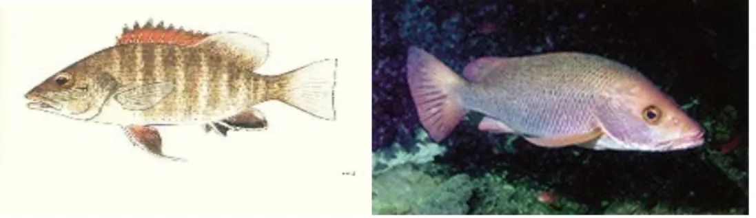
1. Priority species information
● English name: Mangrove red snapper
● Scientific name: Lutjanus argentimaculatus Forsskal, 1775
Source: Fishbase Source: Fishbase
Lutmans argentimaculatus Lutjanus argentimaculatus Juvenile picture by FAO Picture by: Allen G. R.
Morphology
The table below describes some of the characteristics of the mangrove red snappers that include descriptive and meristic characteristics.
Table 6. Descriptive and meristic characteristics of mangrove red snapper Descriptive Characteristics Fins
Body shape lateral fusiform/normal Dorsal fin
Cross section Oval Attributes
Dorsal head profile more or less straight
Fins number 1 Type of eyes more or less
normal
Finlets number
Dorsal 0 – 0 Ventral 0 – 0 Type of
mouth/snout
more or less normal
Spines total 10 -10 Position of mouth Terminal Soft-rays
total
13 – 14 Type of scales ctenoid scales Adipose fin Absent
Caudal fin
SEAFDEC-UNEP-GEF-PHILIPPINES: REP-PH84
Meristic characteristics Attribute More or less truncate;
more or less Normal
Lateral lines 1 Anal fin
Scales on lateral
line 44 – 48
Pored lateral
scales 44 – 48 Fins number 1
Scales in lateral lines
Scale rows above lateral line
4 – 6 Spines total 3 – 3
Scales around caudal
peduncle
Barbels 0 Soft-rays
total
8 – 8 Gill rakers
On lower limb 9 – 12 Paired fins On upper limb 6 – 8
Pectoral Attributes More or less normal Spines 0 Soft rays 16 – 17
Total 16 -20 Pelvics Attributes More or less
normal Position Thoracic
before origin D1
Spines
Soft rays 5 -5 Distribution
The distribution of the mangrove red snappers is mostly concentrated in Southeast Asia and most abundant in the ASEAN region. In the Philippines, the fish is caught in almost all the marine waters of the country.
Life cycle and mating behavior
Available information on the life cycle of the red mangrove snapper shows that the fish spawn all year round especially at the lower latitude (Allen, G.R., 1985).
Length at first maturity/size/weight/age
The length at first maturity of female Lutjanus argentimaculatus was observed to be 57.0 cm total length while the male was 49.6 cm total length (Emata et. Al. 1999). The maximum length reported was 150 cm total length (Torres, F.S.B. Jr., 1991); common length was 80 cm.
and the published maximum weight was 8.7 kg (IGFA 2001). The maximum age reported of the mangrove red snapper was 31 years (Fry G.C., D.T. Brewer and W.N. Venables, 2006) in based from the FISHBASE.
Area of habitat in each stage/migration pattern
The mangrove red snapper is a euryhaline species as such can adjust to a wide range of salinities. Juveniles and young adults can be found in mangrove estuaries and tidal creeks.
Adults are commonly found in groups around coral reefs. The fish migrate to open waters as they grow older to breed and into the offshore reef areas to spawn.
Importance of the site to the life cycle of the species
The refugia site in Coron, Palawan serves as the nursery/feeding area of the mangrove red snapper.
CPUE/STOCK SIZE, MSY
There is no available data on Catch per unit effort (CPUE) of the priority species nor size and MSY to date. However, the available data on CPUE as reported by the USAID ECOFISH Project was the CPUE in the Calamianes group of islands by gear type and not specific to Coron municipality Table 23
Table 7. Catch per unit effort (CPUE) kg/day, number of fishing gear and year Calamianes Island Group
Year 2013 2015 2017
Fishing Gear CPUE N CPUE n CPUE n
Bagnet 228.38 129 155.26 88 83.75 148
Bottom set gillnet 9.53 665 13.61 256 9.06 391
Bottom set longline 9.41 402 9.34 208 9.79 141
Hook & line with float 4.79 5 7.87 257
Multiple handline 3.12 305 4.02 169 3.33 13
Simple hook & line 3.31 250 6.14 98 4.33 167 Spear with compressor 20.38 135 20.45 12 38.01 73
Squid jig 1.63 12 2.74 71 3.30 115
Trammel net 10.04 96 11.87 145 8.33 117
Troll line 18.40 268 13.33 130 11.46 98
Source: USAID ECOFISH Project Final report
SEAFDEC-UNEP-GEF-PHILIPPINES: REP-PH84
Information for GIS mapping Fisheries refugia boundary map
Figure 3. Map of Coron Fish Refugia Site Fishing area by each fishing gear
The refugia site is located in the coastal waters of the six barangays. Municipal fisherfolk can fish anywhere within the municipal waters using different fishing gears either motorized or non-motorized boats.
Important coastal habitats by site
Mangroves are common in the coastal line of the refugia site. The total marine waters where mangroves and coral reefs are abundant cover an area of 2,139 hectares out of the total marine water area of 360,310 hectares of the municipality of Coron. At the refugia site the mangrove area has not been estimated. Seagrass beds are found in barangay Tagumpay, Bintuan and Poblacion.
Geography and Physical Setting
Coron is one of the four municipalities in the Calamianes Group of Islands, situated in the northernmost tip of the Province of Palawan. It is located halfway between Manila and the City of Puerto Princesa. It is the first port of call for ships plying from Manila, and it was the northern gateway to the Province of Palawan.
The municipality has a total land area of 94,952.60 hectares with a population of 38,928 people in 2005, which is also composed of numerous islands and islets. Coron is characterized
by rugged terrain, rolling hills and mountain ranges running almost all directions and extended along the coasts (Figure 2).
The municipality of Coron is composed of 23 barangays, of which 6 are within the Poblacion and 5 are island barangays, as follows:
● Poblacion 1
● Poblacion 2
● Poblacion 3
● Poblacion 4
● Poblacion 5
● Poblacion 6
● Banuang Daan
● Bintuan
● Borac
● Buenavista
● Bulalacao
● Cabugao
● Decabobo
● Decalachao
● Guadalupe
● Lajala
● Malawig
● Marcilla
● San Jose
● San Nicolas
● Tagumpay
● Tara
● Turda
Status of Marine Resources and Habitats a. Mangrove Forest
The entire province of Palawan is declared as mangrove swamp forest reserve under the Presidential Proclamation 2152. However, recent surveys showed that mangrove forests are continuously subjected to cutting, and worst, cleared.
Mangrove forests in the municipality totals to about 771.98 hectares based from the 2005 PCRA data of the FISH Project. Results of the Participatory Coastal Resource Assessment conducted by the FISH Project in 2005 revealed that there are 13 species of true and associate mangrove species in the area. These are:
1. Bakawang Lalaki (Rhizophora apiculata) 2. Bakawang Babae (Rhizophora mucronata) 3. Langarai (Bruguiera parviflora) 4. Pototan (Bruguiera cylindrica)
5. Busain (Bruguiera gymnorrhiza)
SEAFDEC-UNEP-GEF-PHILIPPINES: REP-PH84
6. Tangal (Ceriops tagal)
7. Malatangal (Ceriops decandra)
8. Tabigi (Xylocarpus granatum)
9. Tabau (Lumnitzera littorea)
10. Kulasi (Lumnitzera racemosa) 11. Pagatpat (Sonneratia alba)Tualis
12. Tualis (Osbornia octodonta)
13. Gapas-gapas (Camptostemon philippinensis)
Results from the Mangrove Resource Assessment in Coron conducted by the ECAN Zoning Component of the SEMP-NP (PCSDS) in 2003 showed that the average stocking of mangroves in Coron have an open stocking of 253 trees per hectare considering the DENR stocking classification. In terms of stand volume, the mangrove forest of Coron has an average stand volume of 15.11 cubic meters per hectare that is classified by DENR and FAO as low volume forest stand
Seagrass
The seagrass beds in Coron cover about 1,320.57 hectares (FISH Project PCRA, 2005), which provides habitat to an array of invertebrates that includes sea cucumbers, sea urchins, and various species of shells. Highest percentage of seagrass cover is found in Barangay Decalachao. In general, the seagrass beds of the Municipality of Coron are of fair condition based on the PCRA conducted by FISH in 2005 (Figure 3).
Based on studies, the spatial variation of seagrass diversity, density, biomass, annual productivity and bed extent may be attributed primarily to differences in water quality, substrate type and degree of exposure to wave action.
Dominant species of seagrass found in Coron are Enhalus acoroides, Thalassia hemprichii, Halophila ovalis, Syringodium isoitefolium, Cymodecea rotundata, and Halodule uninervis.
Figure 4. The graph shows the percentage cover of seagrass in the barangays of Coron PCRA Seagrass Assessment (FISH 2005).
Corals
The Calamianes is endowed with extensive fringing coral reefs. Total coral reef in Coron based from the Calamianes 2006 Profile is 1698.05 hectares. The PCRA results in 2005 showed that live coral is only 35% while the dead corals is 21% as shown in Figure 2.
Based on this data, the status of coral reefs of the municipality are in fair condition.
Figure 5 shows the status of coral cover PCRA Coral Reef Assessment (FISH 2005 Socio-economic profile
The users and beneficiaries of the fisheries refugia are the following:
1. Marginal Fishermen 2. Seaweeds Farmer 3.Gleaners
4. Researchers 5. Tourist/Visitors 6. Fish Vendor 7. Fish Buyer 8. Fish Processor 9. Ice Plant
9.Food Establishment 10. Academic Institution 11.Tourism Establishment
12.Boat Owners/operators and crew Resource Value Estimates
Issues and Concerns
CHAPTER 3. FISHERIES REFUGIA MANAGEMENT PLAN
The Fisheries Refugia Management Process at the municipal level follows the process identified in the National Plan for Fisheries Refugia. However, the difference among municipalities like Masinloc are the issues and problems which are particularly present in each of the areas.
The management issues and problems identified are the following:
Ecological well-Being
a. Fisheries Management 1. Overfishing
2. Destructive/illegal fishing practices (dynamite, cyanide, troll fishing; poaching, etc.)
b. Coastal Habitat Management
1. Coastal habitat destruction (mangroves, seagrassess and coral reefs) 2. Vulnerability of coastal habitats from irresponsible human interference c. Coastal Zoning and Shoreline Management
1. Improper utilization of coastal and shoreline 2. Coastal and shoreline encroachment
3. Squatting along the shoreline d. Waste Management
1. Excessive use of chemicals in agriculture and fishpond operation 2. Improper solid and liquid waste disposal from upland
3. Agricultural and river run-off
4. Improper solid waste disposal by boats and big vessels 5. Siltation, particularly run-off water from mining activities
e. Climate Change Mitigation, Adaptation and Disaster Risk Reduction and Management
1. Beach erosion
2. Vulnerability of habitat, fishery and communities to climate change and disaster risk
Human Well-Being
a. Livelihood and Enterprise Development 1. Lack of alternative livelihood
2. Lack of appropriate fishing gears, boats and other equipment b. Coastal Eco-Tourism Development
1. Lack of alternative livelihood from eco-tourism
2. Negative impact of improper utilization of coastal and marine resources for eco-tourism purpose
Good Governance
A. Legal Arrangement and Institutional Development 1. Lack of logistical support for law enforcement
2. Poor coordination between and among government agencies
3. Intrusion of non-resident fishers (commercial fishing) in the municipal waters 4. Limit/prohibition of public access to foreshore access
b. Information, Education and Communication Campaign
1. Lack of proper information about the importance and inter-relationship of marine habitats, fishery and communities in coastal areas
2. Low level of participation of the communities in the coastal and fishery management
Management Interventions 1. Habitat Management
2. Management Zones (Coastal Zoning and Shoreline Management) 3. Business and Financial Plan (Livelihood)
4. Disaster Risk Reduction (Vulnerability/Resilience of Habitat and Resources, Social Vulnerability)
5. Compliance and Enforcement 6. Monitoring and Evaluation MONITORING AND EVALUATION
Monitoring the marine reserve regularly throughout the management process is essential. With baseline data at hand there must be an assessment of key biological and governance indicators. Fisheries stock and diversity both inside and outside the reserve must be determined to measure the value of conserving the stock within the sanctuary. Standard list of governance indicators will reveal how well the fisheries refugia I is being managed. The results will be collected and negative results will be evaluated to identify management problems.
Evaluation in regular basis will be done to determine the effectiveness of the management process and to determine future directions. Questions to be answered are: (1) Were the objectives of the project met ;(2) How well is the MPA doing and (3) What are the reasons for the success/failure of the MPA?.To do this, the identified indicators of the project goals and objectives will be used to determine success or failure.
The following are the reports to be generated including the tools and methodologies to be used, institutional and scheduling arrangements and budgetary and equipment requirements.
Name of Reports Tool/
Forms Methodology Responsible Person Frequency of Data Gathering
Budgetary and Equipment Requirements
SEAFDEC-UNEP-GEF-PHILIPPINES: REP-PH84 1. Accomplishme
nt Reports Form 1.1 Accomplishment
Recording MPA
Coordinator/Managers, MKBA Focal Persons
Monthly
2. Financial
Report Form 1.2 Financial Transaction
Recording MKBA Focal Person Monthly 3. Apprehension
Report Form 1.3 Daily log,recording MPA
Coordinator/Managers, MKBA Focal Persons
Monthly
4. Conditions of Coral Reefs, Seagrass and Mangroves
Form 2.1 Research PCSDS and BFAR Every 2 years
5. Fish Catch
Reports Form 2.2 Daily Recording Fish catch data collectors, MPA
Coordinator/Managers, MKBA Focal Persons
Annually
6. Marginal Fishermen Income Report
Form 2.3 One on one interview
or survey MPA
Coordinators/Managers Annually 7. Socio-
Economic Condition Report
Form 2.4 One on one interview
or survey MPA
Coordinators/Managers Annually
8. Performance Management Evaluation Report
Form 3.1 Group
Discussion/Evaluation MPA
Coordinators/Managers/
MKBA Focal Person, NIMPAMB, TWG
Annually
a. Budgetary and equipment requirement
PERSONAL SERVICES MOOE CAPITAL OUTLAY
1. Incentive for 3 MPA Coordinators/Managers 5,000/mo. X 3 x 12 mo.
P 180,000 per year 2. Incentive for 3 Regular
MPA guards 4,000/mo. x 3 x 12mos.
3. Incentive for 6 Fish Catch Data Collectors P
4,000/mo. x 6 x 12 months
P 248,000.00
1.Fuel Consumption- P 28,000 2. Lubricant-P24,000
3. Food Expenses-P 24,000 4. Regular Meeting, Special Meeting and Consultation -P 141,000/yr.
5. IEC-P 100,000/yr
6. Livelihood-P 150,000/yr 7. Repair and Maintenance- Transportation equipment- P 200,000/yr
1. Equipments-P 500,000 2. Structures-P
550,000
3. Provisions of 3 units Patrol Boat-P 135,000
TOTAL P 672,000/YEAR P 767,800/YEAR P 1.185 MILLION
LIST OF MARINE AND TRANSPORTATION EQUIPMENTS NEEDED
QUANTITY UNIT DESCRIPTION AMOUNT
3 units Motor Engine 6.5 Hp
3 units Binoculars
3 pcs Search Light
3 units GPS
5 units Headset Radio
3 Units Megaphone
3 units Motorized Banca
3 pcs Propeller
3 pcs Shafting
3 pcs Anchor
3 rolls P.E rope
3 pcs Cross joints
3 pcs Flasher
5 units Cellphone
2 pcs Laptop
30 Pcs Life vest
300 pcs Marker Bouys
3 units Solar panel
1 unit Elf Truck
3 units Motorcycle
3 sets Scuba Diving Gears
b. Reporting and Feedback Mechanism Sample of Reporting Form
MONTHLY ACCOMPLISHMENT REPORT
PPA'S Location Budget Implementation
Schedule Physical
Accomplishment
Financial Utilizatio
n Remark
s
Start End Targe
t Actual
SEAFDEC-UNEP-GEF-PHILIPPINES: REP-PH84
Communication and IEC Strategy
There must be a good communication and exchange of information among the players in the implementation of the management plan.
IMPLEMENTING STRUCTURE Management Body and Working Committee
1. Policy Making Body-Narra Integrated Marine Protected Area Management Board (NIMPAMB)
Composition of NIMPAMB Chairperson: Municipal Mayor
Co-Chairperson: Municipal Agriculturist
Members: SB Committee Chairman on Agri- Fishery and Aquatic Resources SB Committee Chairman on Environmental Protection
SB Mandatory IP Representative MPDO
MENRO
Municipal Tourism Officer Municipal Treasurer
Liga ng mga Barangay President OPAG Representative
DENR-PENRO BFAR-PFO
PCSDS Representative PCG
Katala Foundation (NGO) Narra PNP Chief of Police PSU-NARRA Director (academe) MFARMC Chairperson
RIC Representative for each MPA’s Fisherfolk Federation President Fish Warden Federation President Religious Sector Representative Secretariat: Head Secretariat- AT Fishery Sector
Support Staff-MAO Staff
2. Management Committees of NIMPAMB a. Capacity Building Committee
There shall be created a capability building committee which shall ensure that the individuals/body responsible in law enforcement pertaining to the MPA’s are adequately capacitated. The capability building committee shall undertake the following activities;
1. Spearhead and facilitate the conduct of fishery law enforcement trainings in coordination with proper government law enforcement agencies and support groups;
2. Facilitate the deputation of MPA guards by the NIMPAMB and;
3. Recommend to the NIMPAMB the acquisition of equipment, tools and devices necessary to the effective law enforcement and related activities.
b. Law Enforcement Committee
There shall be a law enforcement committee which shall spearhead the day and night seaborne patrols of the MPA guards within and around the MPA’s:
1. Conduct regular monitoring and patrolling activities within and around the MPA’s;
2. Enforce the provisions of MPA ordinance;
3. Conduct the arrest and seizures of violators of the ordinance;
4. Pursue legal action against the violators of the ordinance.
c. Information, Education and Communication Committee
There shall be committee on information and education which shall perform extensive information and education campaign on all matters pertaining to the MPA’s. The committee will directly provide news and information about the
activities and events in the sanctuaries. Among its activities, the IEC committee shall:
1. Install signage inside the MPA’s stating clearly all important provisions in the ordinance. Included in this signage/billboard are the prohibitions, rules and regulations(do’s and don’t’s)inside and outside the sanctuaries;
2. Coordinate with educational institutions such as Day Care Centers, Elementary and High Schools to continuously explain all issues concerning the sanctuaries. To implement regular information and education drives such as in-school film
showing, lectures on marine conservations and protection and trainings like mammal rescue;
3. To establish MPA Information Centers in the component barangays for posting of posters and other environmental bulletins or flyers.
4. To conduct a monthly radio program regarding the activities and plans concerning the MPA’s.
d. Sustainable Financing (Ways and Means) Committee
There shall be a committee on Sustainable Financing which shall head the financial
SEAFDEC-UNEP-GEF-PHILIPPINES: REP-PH84
dealings in relation to the following:
1. Initiate fund sourcing activities for the implementation of MPA Management Plan;
2. Initiate in identifying strategies to raise funds for the activities on the MPA’s;
3. Initiate in identifying and coordinating with possible funding sources;
4. Initiate in reviewing and preparing proposals for fund-sourcing while continuously coordinating with other communities concerned;and
5. Initiate in creation of financial systems and regulations as fisherfolks organization and MPAMB Guidelines.
e. Resource Management and Conservation Committee
There shall be a committee on Resource Management and Conservation Committee which shall head all the activities to administer regulations on the cleanliness of the MPA’s as follows:
1. To coordinate with the Barangay component regarding health and sanitation 2. To plan and formulate waste management plan
f. Monitoring and Evaluation Committee
There shall be a Committee on Monitoring and Evaluation which shall be spearheaded by the organized monitoring team to examine the general status of the sanctuaries, conduct researches and regeneration processes. Other activities of the M & E committee;
1. The Monitoring Team will establish permanent monitoring stations such as quadrate inside and outside each MPA’s;
2. Regular monitoring of coral reefs, seagrass and mangroves;
3. Data gathering and centralization of data previously gathered including the results of Resource Rapid Assessment;
4. Conduct of annual fish catch data monitoring for the MPA’s.
5. Marine Protected Area (MPA) Coordinator/Manager a. Resource Monitoring Team
b. Enforcement Team c. Public Education Tea d. Infrastructure Team e. Livelihood Team
6. Position and Description of Roles and Responsibilities
Powers and Functions of the Narra Integrated Marine Protected Areas Management Board a. Decide matters relating to planning, resource use and protection, and general
administration of the area in accordance with the management plan;
b. Approve budget allocation, proposals, work plans, action plans, guidelines for management of 3 MPA’s in accordance with the management plans;
c. Establish productive partnership, with national and local agencies, local communities ,the academe, NGO’s and such other institutions to ensure the conservation and management of each MPA’s;
d. Initiate the implementation of the delineation of the boundaries of MPA’;
e. Promulgate rules and regulations and impose penalties for violations thereof;
f. Ensure the implementation and enforcement of laws, rules and regulations, policies, programs and projects within the MPA’s;
g. Control and regulate construction, operation and maintenance of structure and utilities within the MPA’s;
h. Monitor and evaluate the performance of the MPA Coordinators/Managers and all those implementing activities and projects in the MPA’S.
i. Appoint the MPA Coordinators/managers through the recommendation of Punong Barangays where the 3 MPA’s are situated and based on internal selection criteria and decide on their compensation and benefits;
j. Generate funds and accept donations, grants; appropriate and disburse the same, and exercise accountability over all funds that may accrue to each MPA’s;
k. Manage the NIMPA Trust Fund;
l. Exercise quasi-judicial functions for adjucating cases of violations of MPA Ordinance and impose penalties for violations of guidelines, rules and regulations within each MPA’S;
m. Deputize individuals for the enforcement of laws , rules and regulations governing conduct within each MPA’s, and prescribe the necessary qualifications therefore;
n. Provide adequate measures to ensure consultation and participation of stakeholders;
o. Possess authority to issue permits and conditions thereto, and determine and collect fees, for the utilization and enjoyment of each MPA’s and the resources therein;
p. Perform such other functions necessary for the fulfilment of the provisions of the MPA Ordinance and other applicable laws, rules and regulations, and as may be required.
Duties and Function of Technical Working Group (TWG) 1. Conduct technical evaluation of the plan;
2. Provide relevant inputs and knowledge base in the implementation of the plan;
and
3. Formulate recommendations as basis for the updating of the plan;
SEAFDEC-UNEP-GEF-PHILIPPINES: REP-PH84 Organizational Chart
CHAPTER 4 MANAGEMENT OBJECTIVES, STRATEGIES AND PROGRAMS/PROJECTS A. ECOLOGICAL WELL-BEING COMPONENT
A.1FISHERIES MANAGEMENT
OBJECTIVES STRATEGIES PROGRAMS/PROJECTS LOCATION
IMPLEMENTATI ON SCHEDULE
PERSONS &
AGENCIES INVOLVED
AMOUNT
1. Marine protected areas managed effectively
1.1 Effectively management of marine protected areas
1.1.1 Re-assessment of biophysical
and socio-economic aspect of the current marine protected areas or fish/marine sanctuaries 1.1.2 Formulation of
management plan for marine protected areas or fish/marine sanctuaries 1.1.3 Activation of MPA Board 1.1.4 Conduct of regular participatory monitoring and evaluation
ALL MPA’s
2017-2018
2017
2017
2017-2024
LGU-OMA, MENRO, MFARMC,
MPDO, Barangay LGU, PCSD,
BFAR
P 400,000.00
2. Closed season in harvesting commercially and ecologically important fish and invertebrates during their spawning season and/or their juvenile stages designated
2.1 Designation of closed season in harvesting commercially and ecologically important fish and invertebrates during their spawning season and/or their juvenile stages.
2.1.1 Conduct of study on the biology and ecology of target species and on the possible socio-economic impacts of closed season 2.1.2 Strict implementation of
closed season management strategy
2.1.3 Continuous of regular participatory monitoring and evaluation
ALL MPA’s 2017-2018
2018-2022
2017-2022
Sangguniang Bayan, Barangay LGU, MAO,
MENRO, MPDO, NFRDI, BFAR
P 300,000.00
SEAFDEC-UNEP-GEF-PHILIPPINES: REP-PH84 3. Fishers, fishing gears
and fishing boats licensed and permitted
3.1 Licensing and permitting of fishers, fishing gears and fishing boats
3.1.1 Identification of allowable fishing gears and fishing methods and activities in zones of MPA’s
3.1.2 Registration of municipal fishers and their fishing gears, boats, and activities 3.1.3 Color and letter coding of
fishing boats 3.1.4 Renewal of licenses 3.1.5 Computerization of
licensing system and data- banking
3.1.6 Conduct of regular participatory monitoring and evaluation
ALL MPA’S
2017
2017-2022
2017-2022 2017-2022 2017-2022
2017-2022
Barangay LGU, Sangguniang Bayan, OMA,
Licensing, MFARMC,
BFARMC, Phil.
Coast Guard, NFRDI
P 200,000.00
4. Construction and operation of fish corrals, and other fishing gears and fishing activities that occupy space in the coastal waters regulated
4.1 Regulation of the construction and operation of fish corrals, and other fishing gears and fishing activities that occupy space in the coastal waters
4.1.1 Enforcement of ordinance regarding guidelines on the construction and operation of fish corrals and related fishing gears
4.1.2 Inventory, mapping and monitoring of existing fish corrals and other fishing gears and activities 4.1.3 Conduct of regular
monitoring and evaluation
ALL MPA’S 2017-2022
Barangay LGU, Sangguniang Bayan, OMA,
Licensing, MFARMC,
BFARMC, Phil. Coast
Guard
P 100,000.00
5. Commercial fishing vessels in the zones of MPA’s
5.1Restriction of commercial fishing vessels in the zones of MPA’S
5.1.1 Delineation and
delimitation of boundaries of MPAs
5.1.2 Construction of mooring buoys on MPAs
5.1.3 Review and formulation of ordinances/existing laws
ALL MPA’s 2017-2022
Barangay LGU, Sangguniang
Bayan, MPDO, OMA,
MENRO, MFARMC,
P 1Million
restricting operation of commercial fishing vessels in the municipal waters 5.1.4 Strict implementation of the
ordinance
5.1.5 Strengthening of different law enforcement groups in the monitoring of the municipal waters 5.1.6 Conduct of regular
participatory monitoring and evaluation
NAMRIA, BFAR
6. Fishery monitoring mechanism on the enforcement of environmental and fishery laws established
6.1Establishment of fishery monitoring mechanism on the enforcement of environmental and fishery laws
6.1.1 Acquisition of patrol boats and communication equipment’s for enforcement activities 6.1.2 Deputation and
strengthening of MPA guards
6.1.3 Creation of MPA Enforcement team 6.1.4 Strict implementation of
fishery laws/ordinances 6.1.5 Construction and
Development of Watch House
6.1.6 Conduct of regular monitoring and patrolling
ALL MPA’s 2017, 2019, 2022
2016, 2019, 2022 2016, 2019, 2022
2015-2024 2016-2017 2018-2021
2015-202024
LGU-OMA, MENRO, MFARMC, MPDC, Bgy.
LGU, PCSD, DENR, BFAR, ELAC,
NFRDI
P 1.5 Million