The activity corridor concept emerged locally as a strategy to restructure South African cities for the benefit of the majority of its residents. Chapter four provides an overview of Durban's case studies of the practice of activity corridors that were selected for the purposes of the MTRP DISSERTATION An Inquiry into the Use of Activity Corridors as Spatial Strategy to Restructure South African Cities.

CONCEPTUAL FRAMEWORK I
Literature Review
- Origins of the Activity Corridor Concept
5 The connections between these international debates and the local development of the activity corridor concept are dealt with in more detail in Chapter Three. Crane's work has been particularly influential in the development of the activity corridor concept.
Establish an Urban Edge
Compact Cities
There are a number of additional criticisms or limitations of the compact city approach in the South African context that require further consideration. Second, it has been suggested that suburban residential settings provide opportunities for the urban poor who do not care about the compact city (Schoonraad 2000; Todes et al2000). The particular concept of the 'compact city' adopted in the South African context is closely intertwined with the concept of the activity corridor.
First, the activity corridor concept provides one of the main strategies to achieve integration and urban restructuring in the "compact integrated city" approach. Second, the activity corridor concept and the “compact integrated city” are both an urban restructuring response to the existing structure and performance of the South African city. The activity corridor concept therefore shares many of the same theoretical foundations as the 'compact integrated city'.
Promoting public transport has been an important part of the activity corridor concept for some time.
Supplying High-Density and Low-Income Housing
Briggs suggests that this approach does not take into account the complexity and diversity of economic trends and locational factors in the urban economy and that the alleged links between the generation of economic development and the 'compact city' have not been sufficiently researched or motivated. There are also a number of economic trends currently affecting South African cities that are likely to limit the ability to grow economically. This includes the processes of economic decentralization and polarization, which perpetuates urban expansion and fragmentation and contributes to the concentration of economic investment in luxury developments and suburban areas and the avoidance of townships and informal areas (Todes et al 2000: 240; Turok 2000) .
This includes their need to maintain important urban-rural connections and their ability to generate additional income from the rental of backyard units, the establishment of shops and the practice of urban farming. Second, a number of housing market trends are likely to limit efforts to provide high-density, low-income housing along activity routes. This includes the anti-urban values of all population groups, the suburban form and location of most middle- and high-income housing developments, and the low density and peripheral location of the majority of low-income housing developed through the National Housing Subsidy. Schoonraad 2000; Todes et al. 2000).
These factors perpetuate the proliferation of low-density housing, which reinforces the existing apartheid spatial structure and creates significant barriers to the development of high-density, low-income housing in core areas and along activity routes.
Providing Public Facilities and Services
These views are broadly supported by the findings of a study by Briggs (1994) on the impact of density on service provision82 in Durban. Briggs also questions the argument that there is spare capacity in existing infrastructure systems in established areas of the city for further development and densification. It is argued that "densification can result in more cost-effective use of the existing system as long as the capacity of the existing system is not exceeded", but that "at the point where the capacity of the system is exceeded, costs can increase dramatically" (Briggs 1994: 71).
In addition, it was noted that areas with low levels or standards of service provision incur significant costs as a result of densification due to the need to upgrade services to higher levels or standards. Given that both activity routes and the majority of services are directly related to roads, this is an issue that requires further consideration.
Creating a Supportive Public Environment
Facilitating Spatial and Social Integration
Key Issues Emerging from the Evaluation
Introduction
- Selection of Case Studies
- Research Methodology
Case Study Descriptions
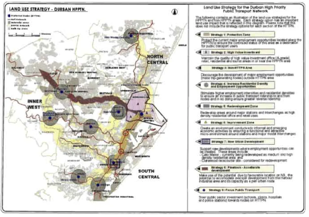
84 See A Spatial Strategy in Support of the High Priority Public Transport Network (Gorgeetaf 2000) and A Desktop Study of Tools and Measures for Establishing and Supporting a Land Use Regime in Support of the High Priority Public Transport Network (Oranjeetaf2001). These strategies relate to the location, type, density, intensity and appropriate design of the land use corridors identified in Durban as part of the FRP. 85 See Table 1 for an identification of the nine land use/public transport corridors that are part of the HPPTN.
Thirdly, experiences with the planning and application of the FRP have highlighted a number of potential limitations to the successful implementation of integrated land use/public transport corridors in Durban. The following contains an illustration of the land use strategies for the HPPTN and non-HPPTN areas. An essential prerequisite for the successful implementation of the LUCNS is its incorporation into the Land Use Management System currently applied in the city.
Fourth, experience with the planning and use of LUCNS has highlighted a number of potential barriers to the successful implementation of land use corridors in Durban.

J Connector J High street
The UCEAP also provides a number of proposals intended to protect and enhance the existing residential amenity and environmental character of the Berea area. A critical component in relation to planning and implementation is clearly the incorporation of the UCEAP into the LUMS and the preparation of a Comprehensive Planning Scheme for the Berea. It is clear that the ability of the UCEAP to direct changes in land use is also related to the social and economic dynamics in the Berea area and the resulting development patterns.
A key informant in the development of the LDP proposals was the identification of the future role of the HGAC. This common vision provided an important source of information for the specific proposals developed under the LDP. This is due to the suburban location of the HGAC and the special nature of the RI03 backbone and adjacent development patterns.
Despite the limitations that have been created in HGAC by these factors and the provisions of the existing TPS, the LDP performs a.

CONCEPTUAL A
EVALUATION OF DURBAN CASE STUDIES I
- Trends and Factors Affecting Implementation
- Compact Cities
This has highlighted a number of theoretical and practical considerations that need to be taken into account in a case study evaluation of the various activity corridors in Durban. The relationships between the activity corridor case studies and the activity corridor concept and its theoretical underpinnings are described below. This represents a significant departure from the retail orientation of activity corridors identified in Cape Town, which provided the original model for the development of the activity corridor concept.
The notion of urbanity had a strong influence on the development of the activity corridor concept and was either implicitly included. Experience with activity corridor case studies, however, has shown that this concern does not generally appear to be a central feature of activity corridor practice in Durban (lyerpers cam 2001). If the activity corridor case studies are to be successfully implemented, they will obviously need to be translated into appropriate land use areas and control in terms of LUMS.
However, the activity corridor case studies have generally not engaged in the urban sustainability debate to any significant extent.
REQUIREMENTS OF AN ACTIVITY CORRIDOR STRATEGY
- Stimulating Local Economic Development
- Linkages with Other Levels of Planning and Implementation
FourtWy, one of the primary mechanisms proposed as part of activity corridor strategies to promote public transport is the development of high-. The key argument advanced in support of the provision of public facilities and services through an activity corridor strategy is that the concentration. There are a number of trends and factors influencing the prospects for targeting public investment in facilities and infrastructure along activity routes as part of an activity corridor strategy.
This approach is clearly more limited than the provisions of the activity corridor concept, but can be a useful part of an activity corridor strategy. SixtWy, the ability to promote social integration through an activity corridor strategy involving infill along activity routes has been questioned by the experiences of low-income housing projects in areas such as Cato Manor. And finally, a better understanding of the goals and requirements of an activity corridor strategy should be encouraged by development control officials, transportation planners and others locally.
Firstly, an activity corridor strategy should be conceptualized as part of the wider spatial planning and restructuring proposals of the city, which should clearly include other elements in addition to activity corridors.

8. APPENDICES I
Interviews and Personal Communications
Sources of Figures and Tables
The following appendix provides a glossary of the key terms and abbreviations referred to in the thesis. In terms of the LUMS, a Comprehensive Planning Scheme is a statutory planning document that normally applies to larger and more complex urban and metropolitan areas (TRPC 2000: 9). An Interim Site Planning Area is one of four Special Case Zones under the LUMS that provides an interim control measure for transitional projects.
A Special Site Planning Area is one of the four Special Occasion Areas in the LUMS data that applies to "urban and rural areas where there is a need for site-specific development management, e.g. It refers to the visual and the spatial arrangement of the vertical and horizontal elements of a city (usually buildings and the spaces between them), whose relationships define the qualities of urban space (Chittenden 1990: 6; WCEDF 1995: vii). The size and shape of the city and the density or intensity of people and activities within the settlement.
A review of existing theory and recent practice regarding activity corridors yields different interpretations and definitions of 'activity corridors'.