EMNAMBITHI/LADYSMITH MUNICIPALITY SPATIAL DEVELOPMENT FRAMEWORK
DRAFT CONSOLIDATED REPORT
1/11/2015
EMNAMBITHI/LADYSMTH MUNICIPALITY
DEPARTMENT: DEVELOPMENT PLANNING AND HUMAN SETTLEMENTS TOWN PLANNING SECTION
EXECUTIVE MANAGER : Mr PS Mkhize
DEVELOPMENT PLANNING P.O. BOX 3978/612 AND HUMAN SETTLEMENTS Ladysmith
3370
Tel (Work) : 0366372091
Email Address : [email protected]
QUERIES:
TOWN PLANNER: Mr K.K. Hlela DEVELOPMENT PLANNING P.O. BOX 29 AND HUMAN SETTLEMENTS Ladysmith
3370
Cell (Work) : 0829094515
Email Address : [email protected]
PAGE NO.
1 INTRODUCTION __________________________________________________________________________________________________________________________ 1 1.1 PURPOSE _____________________________________________________________________________________________________________________________ 1 1.2 EMNAMBITHI/LADYSMITHMUNICIPALITY OVERVIEW ____________________________________________________________________________________________ 1 1.3 DEFINING SPATIAL DEVELOPMENT FRAMEWORK ___________________________________________________________________________________________________ 4 1.4 AIMS AND OBJECTIVES ____________________________________________________________________________________________________________________ 6 1.5 SCOPE OF THE ELMSDF ___________________________________________________________________________________________________________________ 7 1.6 LIMITATIONS OF THE ELMSDF ______________________________________________________________________________________________________________ 7 2 REGIONAL CONTEXT _______________________________________________________________________________________________________________________ 8 2.1 ACCESS _______________________________________________________________________________________________________________________________ 8 2.2 DISTRICT SPATIAL ECONOMY ________________________________________________________________________________________________________________ 8 2.3 REGIONAL TOURIST DESTINATIONS ____________________________________________________________________________________________________________ 8 2.4 UTHUKELA CATCHMENT MANAGEMENT AREA ____________________________________________________________________________________________________ 9 2.5 IMPLICATIONS FOR THE SDF_________________________________________________________________________________________________________________ 9 3 POLICY CONTEXT ________________________________________________________________________________________________________________________ 11 3.1 SPATIAL PLANNING MANDATE _______________________________________________________________________________________________________________ 11 3.2 NATIONAL SPATIAL PLANNING POLICY __________________________________________________________________________________________________________ 12 3.2.1 The National Development Plan _____________________________________________________________________________________________________ 12 3.2.2 SPATIAL PLANNING AND LAND USE MANAGEMENT ACT, 2013 ____________________________________________________________________________ 12 3.2.3 Comprehensive Rural and Development Programme ____________________________________________________________________________________ 13 3.2.4 The Comprehensive Plan for the Development of Sustainable Human Settlements ____________________________________________________________ 13 3.3 PROVINCIAL SPATIAL DEVELOPMENT VISION _____________________________________________________________________________________________________ 14 3.3.1 Provincial Growth and Development Strategy __________________________________________________________________________________________ 14 3.3.2 Planning and Development Act _____________________________________________________________________________________________________ 14 3.4 DISTRICT CONTEXT ______________________________________________________________________________________________________________________ 16 3.4.1 Uthukela District SDF _____________________________________________________________________________________________________________ 16
4 SPATIAL ANALYSIS _______________________________________________________________________________________________________________________ 19 4.1 SETTLEMENTPATTERN ________________________________________________________________________________________________________________ 19 4.1.1 Urban Settlements _______________________________________________________________________________________________________________ 19 4.1.2 Peri-urban Settlements ____________________________________________________________________________________________________________ 27 4.1.3 Rural Settlements ________________________________________________________________________________________________________________ 29 4.1.4 Smaller Settlements ______________________________________________________________________________________________________________ 32 4.1.5 Settlement Density _______________________________________________________________________________________________________________ 33 4.2 CURRENTLANDUSE __________________________________________________________________________________________________________________ 34 4.2.1 Commercial Agriculture ___________________________________________________________________________________________________________ 34 4.2.2 Settlements _____________________________________________________________________________________________________________________ 36 4.2.3 Environmental Areas ______________________________________________________________________________________________________________ 36 4.3 SPATIAL ECONOMY ______________________________________________________________________________________________________________________ 36 4.3.1 Industry ________________________________________________________________________________________________________________________ 36 4.3.2 Trade and Commerce _____________________________________________________________________________________________________________ 37 4.3.3 Agriculture ______________________________________________________________________________________________________________________ 38 4.3.4 Mining _________________________________________________________________________________________________________________________ 41 4.3.5 Tourism ________________________________________________________________________________________________________________________ 41 4.4 LAND OWNERSHIP PATTERN _______________________________________________________________________________________________________________ 42 4.4.1 Ingonyama Trust Land ____________________________________________________________________________________________________________ 42 4.4.2 Traditional Council Areas __________________________________________________________________________________________________________ 42 4.4.3 privately Owned Land _____________________________________________________________________________________________________________ 42 4.4.4 state land ______________________________________________________________________________________________________________________ 43 4.4.5 Servitudes ______________________________________________________________________________________________________________________ 43 4.4.6 syndicate ownership ______________________________________________________________________________________________________________ 43 4.4.7 communal property Instiutions (cpI’s) ________________________________________________________________________________________________ 43 4.5 LAND USE MANAGEMENT _________________________________________________________________________________________________________________ 43 4.5.1 Town Planning Scheme Areas _______________________________________________________________________________________________________ 44 4.5.2 Areas Outside Town Planning Scheme ________________________________________________________________________________________________ 44
4.6.2 Land Restitution _________________________________________________________________________________________________________________ 46 4.6.3 Land Redistribution _______________________________________________________________________________________________________________ 48 4.7 INFRASTRUCTURE ASSESSMENT _____________________________________________________________________________________________________________ 48 4.7.1 Electricity _______________________________________________________________________________________________________________________ 48 4.7.2 Water _________________________________________________________________________________________________________________________ 49 4.7.3 Sanitation ______________________________________________________________________________________________________________________ 50 4.8 ROAD NETWORK _______________________________________________________________________________________________________________________ 50 4.8.1 National Roads __________________________________________________________________________________________________________________ 51 4.8.2 Provincial Roads _________________________________________________________________________________________________________________ 51 4.8.3 Other Provincial Routes ___________________________________________________________________________________________________________ 53 4.8.4 district and local Roads ____________________________________________________________________________________________________________ 53 4.9 TRANSPORTATION INFRASTRUCTURE __________________________________________________________________________________________________________ 53 4.9.1 Rail ____________________________________________________________________________________________________________________________ 53 4.9.2 Public Transport _________________________________________________________________________________________________________________ 55 4.9.3 Air Transport ____________________________________________________________________________________________________________________ 55 4.10 SOCIAL FACILITIES ______________________________________________________________________________________________________________________ 55 4.10.1 Health Facilities __________________________________________________________________________________________________________________ 55 4.10.2 Education Facilities _______________________________________________________________________________________________________________ 57 4.10.3 Libraries ________________________________________________________________________________________________________________________ 57 4.10.4 Police Stations ___________________________________________________________________________________________________________________ 57 4.10.5 Cemeteries _____________________________________________________________________________________________________________________ 57 4.10.6 LandFill Sites ____________________________________________________________________________________________________________________ 58 4.11 SUSTAINABLE HUMAN SETTLEMENTS __________________________________________________________________________________________________________ 58 4.11.1 Housing Delivery _________________________________________________________________________________________________________________ 58 4.11.2 Slums Clearance _________________________________________________________________________________________________________________ 58 4.11.3 Rural Housing ___________________________________________________________________________________________________________________ 59 4.11.4 Breaking New Ground Projects ______________________________________________________________________________________________________ 59 4.11.5 Middle Income and Upmarket Housing _______________________________________________________________________________________________ 59 4.12 PHYSICAL ENVIRONMENT _________________________________________________________________________________________________________________ 59
4.13 HERITAGE AREAS _______________________________________________________________________________________________________________________ 60 4.13.1 Heritage Sites ___________________________________________________________________________________________________________________ 60 4.13.2 Archaelogical Sites _______________________________________________________________________________________________________________ 61 4.14 WATER RESOURCES AND CATCHMENT MANAGEMENT _______________________________________________________________________________________________ 61 4.14.1 Thukela Water Management Area ___________________________________________________________________________________________________ 61 4.14.2 Wetlands _______________________________________________________________________________________________________________________ 64 4.15 BIODIVERSITY _________________________________________________________________________________________________________________________ 65 4.15.1 Flora __________________________________________________________________________________________________________________________ 65 4.15.2 Fauna __________________________________________________________________________________________________________________________ 66 4.16 PROTECTED AND DEVELOPMENT EXCLUSION AREAS ________________________________________________________________________________________________ 66 4.16.1 Formal Protected Areas ___________________________________________________________________________________________________________ 66 4.16.2 Informal Protected Areas __________________________________________________________________________________________________________ 67 4.16.3 Areas That Require Conservation ____________________________________________________________________________________________________ 67 4.17 SPATIAL PLANNING ISSUES _________________________________________________________________________________________________________________ 68 4.17.1 Policy Directives _________________________________________________________________________________________________________________ 69 4.17.2 Regional and External Influences ____________________________________________________________________________________________________ 69 4.17.3 Internal Spatial Dynamics and Trends ________________________________________________________________________________________________ 70 5 SPATIAL DEVELOPMENT TRENDS AND PATTERNS ______________________________________________________________________________________________ 72 5.1 POLICY DIRECTIVES ______________________________________________________________________________________________________________________ 72 5.1.1 Spatial Planning Mandate _________________________________________________________________________________________________________ 72 5.1.2 Rural Development _______________________________________________________________________________________________________________ 72 5.1.3 Sustainable Human Settlements ____________________________________________________________________________________________________ 73 5.1.4 Sustainable Development __________________________________________________________________________________________________________ 73 5.2 REGIONAL AND EXTERNAL INFLUENCES ________________________________________________________________________________________________________ 74 5.2.1 Emnambithi/Ladysmith Municipality as Part of Uthukela District __________________________________________________________________________ 74 5.2.2 Uthukela River Catchment _________________________________________________________________________________________________________ 74 5.2.3 The N3 and the N11 Development Corridors ___________________________________________________________________________________________ 74 5.2.4 Ladysmith Town as a Regional Hub __________________________________________________________________________________________________ 75
5.3.2 Population Structure ______________________________________________________________________________________________________________ 76 5.3.3 Population Distribution ____________________________________________________________________________________________________________ 76 5.3.4 Urbanisation ____________________________________________________________________________________________________________________ 76 5.3.5 Inequitable Access to basic Services __________________________________________________________________________________________________ 78 5.3.6 Low Affordability Levels ___________________________________________________________________________________________________________ 78 5.3.7 Economic Stagnation _____________________________________________________________________________________________________________ 78 5.4 SPATIAL FACTORS _______________________________________________________________________________________________________________________ 78 5.4.1 Spatial Fragmentation ____________________________________________________________________________________________________________ 78 5.4.2 Dislocated Rural Settlement ________________________________________________________________________________________________________ 79 5.4.3 Spatial Dynamics within Rural Settlements ____________________________________________________________________________________________ 80 5.4.4 Urban Sprawl ___________________________________________________________________________________________________________________ 80 5.4.5 Urban Decay ____________________________________________________________________________________________________________________ 82 5.4.6 Spatial Impact of the Land Reform Programme ________________________________________________________________________________________ 82 5.5 BIO-PHYSICAL FACTORS ___________________________________________________________________________________________________________________ 84 5.5.1 Environmental Degradation ________________________________________________________________________________________________________ 84 5.5.2 Biodiversity and protected areas ____________________________________________________________________________________________________ 84 5.5.3 Flooding ________________________________________________________________________________________________________________________ 84 5.5.4 Vulnerable Areas _________________________________________________________________________________________________________________ 84 5.5.5 Water and Water Quality __________________________________________________________________________________________________________ 85 5.5.6 Climate Change __________________________________________________________________________________________________________________ 85 5.6 SWOTANALYSIS _____________________________________________________________________________________________________________________ 87 5.6.1 Strengths _______________________________________________________________________________________________________________________ 87 5.6.2 Weaknesses _____________________________________________________________________________________________________________________ 87 5.6.3 Opportunities ___________________________________________________________________________________________________________________ 88 5.6.4 Threats ________________________________________________________________________________________________________________________ 88 6 SPATIAL DEVELOPMENT CONCEPT AND STRATEGY _____________________________________________________________________________________________ 89 6.1 MUNICIPAL SPATIAL DEVELOPMENT VISION _____________________________________________________________________________________________________ 89 6.2 SPATIAL PLANNING AND DEVELOPMENT GOALS __________________________________________________________________________________________________ 89
6.5.1 Focusing Development in Strategic Nodal Points _______________________________________________________________________________________ 94 6.5.2 Development Corridors as Investment Routes __________________________________________________________________________________________ 94 6.5.3 Developing Sustainable Human Settlements ___________________________________________________________________________________________ 95 6.5.4 Rural-Urban Interface _____________________________________________________________________________________________________________ 96 6.5.5 Green Corridors and Lungs _________________________________________________________________________________________________________ 96 6.5.6 Protection of High Value Agricultural Land ____________________________________________________________________________________________ 97 6.5.7 Integration of Different Landscapes and Land Use Zones _________________________________________________________________________________ 97 7 SPATIAL FRAMEWORK ____________________________________________________________________________________________________________________ 99 7.1 IMPROVING ACCESS AND MOVEMENT _________________________________________________________________________________________________________ 99 7.1.1 The N2 and N11 National/Provincial Corridor _________________________________________________________________________________________ 100 7.1.2 Primary Development Corridors ____________________________________________________________________________________________________ 101 7.1.3 Secondary Corridors _____________________________________________________________________________________________________________ 102 7.1.4 Tertiary Corridors _______________________________________________________________________________________________________________ 103 7.1.5 Mixed Use Development Corridor __________________________________________________________________________________________________ 105 7.2 FACILITATING THE DEVELOPMENT OF A SYSTEM OF INVESTMENT AND SERVICE NODES _______________________________________________________________________ 105 7.2.1 Primary Node __________________________________________________________________________________________________________________ 108 7.2.2 Secondary Nodes ________________________________________________________________________________________________________________ 108 7.2.3 Tertiary Centres _________________________________________________________________________________________________________________ 111 7.3 PROMOTING A CONTINUUM OF SETTLEMENT CLUSTERS ____________________________________________________________________________________________ 111 7.3.1 Urban Settlements ______________________________________________________________________________________________________________ 112 7.3.2 Peri-urban Settlements ___________________________________________________________________________________________________________ 112 7.3.3 Dense Rural Settlements __________________________________________________________________________________________________________ 115 7.3.4 Scattered Rural Settlements _______________________________________________________________________________________________________ 115 7.3.5 Settlement Clusters (Complexes) ___________________________________________________________________________________________________ 115 7.4 PROMOTING COMPACT DEVELOPMENT _______________________________________________________________________________________________________ 116 7.4.1 Urban Edge ____________________________________________________________________________________________________________________ 117 7.4.2 Settlement Edge ________________________________________________________________________________________________________________ 117 7.4.3 Densification ___________________________________________________________________________________________________________________ 118
7.5.2 Colenso Town Regeneration Programme_____________________________________________________________________________________________ 123 7.5.3 Ladysmith/Emnambithi Town _____________________________________________________________________________________________________ 123 7.5.4 CBD Southern Extension Node _____________________________________________________________________________________________________ 124 7.5.5 HelpMekaar Corridor ____________________________________________________________________________________________________________ 125 7.6 DEVELOPING SUSTAINABLE HUMAN SETTLEMENTS _______________________________________________________________________________________________ 127 7.6.1 Land Release ___________________________________________________________________________________________________________________ 127 7.6.2 Housing Delivery ________________________________________________________________________________________________________________ 130 7.6.3 Slums Clearance ________________________________________________________________________________________________________________ 130 7.6.4 Rural Housing __________________________________________________________________________________________________________________ 130 7.6.5 Breaking New Ground Projects _____________________________________________________________________________________________________ 130 7.6.6 Middle Income and Upmarket Housing ______________________________________________________________________________________________ 131 7.6.7 Social Housing __________________________________________________________________________________________________________________ 131 7.7 BULK INFRASTRUCTURE DEVELOPMENT _______________________________________________________________________________________________________ 132 7.7.1 Sanitaton ______________________________________________________________________________________________________________________ 132 7.7.2 Water ________________________________________________________________________________________________________________________ 132 7.8 IMPROVING ACCESS TO SOCIAL FACILITIES _____________________________________________________________________________________________________ 133 7.8.1 Health ________________________________________________________________________________________________________________________ 134 7.8.2 Meeting spaces _________________________________________________________________________________________________________________ 134 7.8.3 Education Facilities ______________________________________________________________________________________________________________ 134 7.8.4 Facilitating Efficient movement and public transport ___________________________________________________________________________________ 135 7.9 PROMOTING RURAL DEVELOPMENT AND AGRARIAN REFORM ________________________________________________________________________________________ 136 7.9.1 Emerging Farmer Settlement ______________________________________________________________________________________________________ 136 7.9.2 Land Tenure Upgrading Areas _____________________________________________________________________________________________________ 138 7.10 LOCAL ECONOMIC DEVELOPMENT __________________________________________________________________________________________________________ 138 7.10.1 Tourism _______________________________________________________________________________________________________________________ 138 7.10.2 Agriculture _____________________________________________________________________________________________________________________ 139 7.10.3 Commerce and Industry __________________________________________________________________________________________________________ 139 7.11 ENVIRONMENTAL MANAGEMENT ___________________________________________________________________________________________________________ 140 7.11.1 Catchment Management _________________________________________________________________________________________________________ 141
7.11.5 PROTECTED AREA DEVELOPMENT __________________________________________________________________________________________________ 142 7.11.6 Wetland Management ___________________________________________________________________________________________________________ 143 7.11.7 Biodiversity Management Zones ___________________________________________________________________________________________________ 143 7.12 MANAGEMENT OF AGRICULTURAL LAND ______________________________________________________________________________________________________ 146 7.12.1 High Potential Agricultural Land ___________________________________________________________________________________________________ 146 7.12.2 Good Agricultural Potential _______________________________________________________________________________________________________ 146 7.12.3 Low Agricultural Potential ________________________________________________________________________________________________________ 146 7.12.4 Agricultural Potential lost due to transformation ______________________________________________________________________________________ 149 7.13 CONSOLIDATED SPATIAL DEVELOPMENT FRAMEWORK _____________________________________________________________________________________________ 149 8 IMPLEMENTATION PLAN _________________________________________________________________________________________________________________ 162 8.1 LAND USE MANAGEMENT FRAMEWORK ______________________________________________________________________________________________________ 163 8.1.1 Land Use Management System ____________________________________________________________________________________________________ 163 8.1.2 SPATIAL PLANNING AND LAND USE MANAGEMENT ACT (ACT NO. 16 OF 2013) ______________________________________________________________ 163 8.1.3 Conclusion and Way forward ______________________________________________________________________________________________________ 171 8.1.4 Definition and Purpose of Scheme __________________________________________________________________________________________________ 171 8.1.5 Scheme Approach _______________________________________________________________________________________________________________ 172 8.1.6 THE LINK BETWEEN THE SDF AND A SCHEME _________________________________________________________________________________________ 173 8.1.7 ZOning and Management Overlays _________________________________________________________________________________________________ 176 8.1.8 Development Parameters / Scheme Controls _________________________________________________________________________________________ 177 8.2 THEAMALGAMATIONOFEMNAMBITHI/LADYSMITHMUNICIPALITYANDINDAKAMUNICIPALITY ___________________________________________________ 178 8.3 REDETERMINATIONOFWARDBOUNADRIES ______________________________________________________________________________________________ 179 8.4 STRATEGICINFRASTRUCTUREPROJECTS(SIP) _____________________________________________________________________________________________ 183 8.5 GEOGRAPHICALNAMINGANDRENAMINGOFSTREETSANDPUBLICPLACES ____________________________________________________________________ 184 8.6 ALIGNMENT WITH THE NEIGHBOURING MUNICIPALITIES ____________________________________________________________________________________________ 185 8.6.1 Uthukela District Municipality _____________________________________________________________________________________________________ 186 8.6.2 Umtshezi Municipality ___________________________________________________________________________________________________________ 187 8.6.3 Okhahlamba Local Municipality ____________________________________________________________________________________________________ 189 8.6.4 Indaka Local MunicipalityIndaka Local Municipality is located to the East of the ELM, and also forms part of the UTDM. ____________________________ 190
8.7.1 Spatial Monitoring Approach and Process ____________________________________________________________________________________________ 195 8.7.2 Strategy 1: Improving Access and Movement _________________________________________________________________________________________ 197 8.7.3 Strategy 2: Facilitating Development of a System of Investment and Service Nodes __________________________________________________________ 198 8.7.4 Strategy 3: Promoting a Continuum of Settlement Clusters ______________________________________________________________________________ 199 8.7.5 Strategy 4: Promoting Compact Development ________________________________________________________________________________________ 200 8.7.6 Strategy 5: Urban Development Priority Areas ________________________________________________________________________________________ 202 8.7.7 Strategy 6: Developing Sustainable Human Settlements ________________________________________________________________________________ 204 8.7.8 Strategy 7: Bulk Infrastructure Development _________________________________________________________________________________________ 206 8.7.9 Strategy 8: Improving Access to Social Facilities _______________________________________________________________________________________ 208 8.7.10 Strategy 9: Promoting Rural and Agrarian Reform _____________________________________________________________________________________ 209 8.7.11 Strategy 10: Promoting Local Economic Development __________________________________________________________________________________ 210 8.7.12 Strategy 11: Environmental Management ____________________________________________________________________________________________ 211 8.7.13 Strategy 12: Management of Agricultural Land _______________________________________________________________________________________ 212 8.8 STRATEGIC SPATIAL PLANNING PROJECTS ______________________________________________________________________________________________________ 213 8.9 CATALYSICCOMMERCIALPROJECTS ____________________________________________________________________________________________________ 215 8.10 CAPITAL INVESTMENT FRAMEWORK _________________________________________________________________________________________________________ 235
CO2: Carbon Dioxide
CPA: Communal Property Association CPI: Communal Property Institution
CRDP: Comprehensive Rural Development Programme CBNRM: Community Based Natural Resource Management DAC: Direct Access Service Centre
DAFF: Department of Agriculture Forestry and Fisheries DFA: Development Facilitation Act
DOT: Department of Transport
DRDLR: Department of Rural Development and Land Reform DWA: Department of Water Affairs
DWAF: Department of Water Affairs and Forestry ELM: Emnambithi/Ladysmith Municipality EIA: Environmental Impact Assessment EMF: Environmental Management Framework ESTA: Extension of Security of Tenure Act EURP: Ezakheni Urban Renewal Programme
GIS: Geographic Information Management System HSP: Housing Sector Plan
KPA: Key Performance Area
LED: Local Economic Development Plan LFTEA: Less Formal Township Establishment Act LITP: Local Integrated Transport Plan
LRAD: Land Reform for Agricultural Development LUMS: Land Use Management Systems
LUS: Land Use Scheme MAR: Mean Annual Runoff MSA: Municipal Systems Act NDP: National Development Plan
NEMA: National Environmental Management Act OLM: Okhahlamba Local Municipality
PDA: Planning and Development Act
PGDS: Provincial Growth and Development Strategy PLAS: Pro-active Land Acquisition Strategy
PTP: Public Transport Plan
RDP: Reconstruction and Development Programme RLCC: Regional Land Claims Commission
SALA: Sub-division of Agricultural Land Act
SEA: Strategic Environmental Assessment
SPLUMB: Spatial Planning and Land Use Management Bill SWOT: Strengths, Weaknesses, Opportunities & Constraints UDP: UKhahlamba Drakensburg Park
WSDP: Water Services Development Plan WWTW: Waste Water Treatment Works WTW: Water Treatment Works
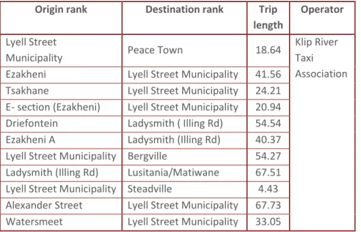
TABLE 1: MINIBUS-TAXI SERVICES OPERATING FROM MUNICIPAL RANKS ... 55
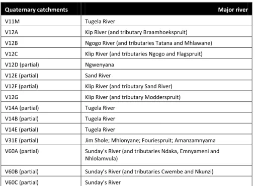
TABLE 2: DRAINAGE AREAS AND MAJOR RIVERS ... 62
TABLE 3: NODES, FUNCTIONS AND TYPES OF SERVICES... 107
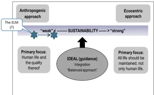
TABLE OF FIGURES FIGURE 1: SUSTAINABILITY SCALE ... 73
FIGURE 2: MUNICIPAL DEVELOPMENT VISION ... 89
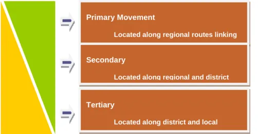
FIGURE 3: CLASSIFICATION OF CORRIDORS ... 100
FIGURE 4: SCHEME AND OVERLAYS ... 177
EMNAMBITHI/LADYSMITH MUNICIPALITY SPATIAL DEVELOPMENT FRAMEWORK | INTRODUCTION JUNE 2015 1.1 PURPOSE
This document presents a Spatial Development Framework (SDF) for the Emnambithi/Ladysmith Municipality (ELM). It is a further development of the municipality’s Integrated Development Plan (IDP), and a means to fulfil the requirements of the Municipal Systems Act (MSA), Act No. 34 of 2000 hereafter referred to as the MSA and the Spatial Land Use Management Act, 2013 (SLPUMA). It is prepared in accordance with the MSA regulations, SPLUMA and the Department of Rural Development and Land Reform (DRDLR) guidelines for the formulation of SDFs.
1.2 EMNAMBITHI/LADYSMITH MUNICIPALITY OVERVIEW
Emnambithi/Ladysmith Municipality (ELM) forms part of the UThukela District Municipality in the KwaZulu-Natal Province.
It is located along the north-western boundary of UThukela District and is bordered by the Free State Province to the west, Dannhauser Municipality to the north, Endumeni and Indaka Municipalities to the northeast and east, Umtshezi Municipality to the southeast and Okhahlamba Municipality to the southwest (refer Map 1 below). It covers an area of approximately
3020km2 in extent and has a population of about 242 707 people as per Global Insight (2014). This indicates an average annual population growth rate of 0.84% per year since 2001.
The municipality is bisected by development corridors and trade routes of national significance, that is the N11 which runs in a north south direction linking KwaZuluNatal with Mpumalanga Province and the N3 which runs in an east west direction linking Durban and Johannesburg Metropolitan areas.
These routes/development corridors play a significant role in structuring land uses. A railway line also bisects the municipality which links areas of Johannesburg and Durban.
The upgrade of the said railway line is a presidentially prioritised infrastructure development programme. The recently introduced Provincial Growth and Development Strategy for KwaZulu-Natal classifies Ladysmith as a tertiary node with regional significance. This means that the area is earmarked for the location of infrastructure that serves the whole of Uthukela District and beyond, and connects the region with the major urban centres such as Durban and Johannesburg.
EMNAMBITHI/LADYSMITH MUNICIPALITY SPATIAL DEVELOPMENT FRAMEWORK | INTRODUCTION JUNE 2015
serves as a service centre and administrative centre for the whole of Uthukela District, and a commercial hub for the north- western part of KwaZulu-Natal. In terms of the socio-economic macro context, the municipality is midway between the National Primary Nodes of Johannesburg and Durban. Ladysmith provides higher order goods to the whole district and houses most of the major industrial activities. Manufacturing activity is primarily concentrated in the Ladysmith-Ezakheni cluster, and is dominated by the textile and clothing sub-sector. The presence of industries within the municipality is seen as a huge advantage, these industries include the Nambithi Industrial Area, Dansekraal Industrial Area and Pieters Industrial Area.
The municipality is also well located in relation to at least two of the major tourism destinations in KwaZulu-Natal. In fact, it serves as a base for the exploration of the Battlefields to the north and Ukhahlamba-Drakensburg Park to the south. The latter is a World Heritage Site and a world acclaimed tourist destination. The municipality is located in an region with a rich heritage and military history ranging from the uMfecane period (early 1800s) to the turn of the century when the Boers tried to stem the tide of British imperialism. The town of Ladysmith is located in the foothills of the Drakensberg Mountains, which form the escarpment. The dominant topographical features of the ELLM are valley slopes and undulating hills, but the
moderate to steep slopes, rolling hills, flat plains, dolerite koppies and steep ridges.
The settlement pattern in the ELM reflects the spatial imprints of the apartheid past, which continue to undermine efforts towards equitable development. The impact of separate development and apartheid policies on settlement can broadly be categorised as follows:
• Towns (urban centres), referring to urban centres of Ladysmith and Colenso;
• Formal township of Ezakheni.
• Peri-urban Settlements such as Roosboom and St Chads
• Rural settlements Matiwane, Driefontein, etc.
Apartheid pushed the poor into Ezakheni Township and the dislocated settlements to the north of Ladysmith. These areas are far away from economic opportunities. Land use management in municipality also has imprints of past planning.
This was mainly evident from the urban areas of Ladysmith and Colenso that were guided by the Town Planning Schemes while the other areas just remained without any formal land use controls. However, the situation is changing given the
EMNAMBITHI/LADYSMITH MUNICIPALITY SPATIAL DEVELOPMENT FRAMEWORK | INTRODUCTION JUNE 2015
Act, Act No. 6 of 2008 that required Emnambithi/ Ladysmith Municipality to introduce a wall-to-wall Land Use Scheme (LUS) within five years from the implementation date of the relevant provisions of the Act. The municipality has commenced with the processes to respond to this provincial directive though the development of the local area plans that covers the entire municipal area.
The municipality is also located in the uThukela Water Management Area (WMA) with the Klip River and Sunday’s River and their tributaries traversing the municipality. These rivers drain into the Tugela River (also known as uThukela), which is the largest river system in KwaZulu-Natal. The Tugela River forms part of the Tugela River Catchment, which is approximately 30 000 km2 in extent. This is one of the important river catchments in South Africa, which drains from the Drakensberg escarpment into the Indian Ocean. There is substantial runoff from the Tugela catchment as a result of high rainfall.
1.3 DEFINING SPATIAL DEVELOPMENT FRAMEWORK
document that guides decision making relating to the development of land. It covers the whole municipal area and aligns with similar plans for the neighbouring municipalities, and is prepared in line with the within the national and provincial spatial planning policy prescripts. Other key features of the ELM SDF are as follows:
It is a component of the IDP and provides a spatial interpretation of the strategies and programmes already contained within the IDP.
It is a legislative requirement and is thus binding to the municipality and all who are involved in land development within the ELM.
It forms part of the spatial transformation tools that guide the form and location of future spatial development in a manner that addresses the imbalances of the past and promotes equitable development.
It forms part of a Land Use Management System (LUMS) for the ELM.
EMNAMBITHI/LADYSMITH MUNICIPALITY SPATIAL DEVELOPMENT FRAMEWORK | INTRODUCTION JUNE 2015
EMNAMBITHI/LADYSMITH MUNICIPALITY SPATIAL DEVELOPMENT FRAMEWORK | INTRODUCTION JUNE 2015
Systems Act, Act No. 32 of 2000. The MSA requires a municipality to prepare and adopt an SDF as a component of its Integrated Development Plan (IDP). As such, the ELM SDF has a legal status and is binding upon the municipality and all those involved in land use planning and related activities.
Most importantly, the municipality’s SDF facilitates development of a spatial structure that promotes integrated development and an efficient delivery of services. The SDF gives direction to future planning and development within the municipality, and provide a framework for more detailed and area specific development plans. It provides a framework for the preparation of more detailed and area specific spatial plans and a wall-to-wall Land Use Scheme (LUS) as envisaged in the KwaZulu-Natal Planning and Development Act (PDA), Act No.
06 of 2008. It forms part of the systems and procedures at the disposal of the municipality to perform on its developmental mandate and facilitate removal of spatial remnants of the apartheid past. The SDF will enable the municipality to manage its land resources effectively in a sustainable manner. In short, the ELM SDF defines and facilitates a progressive move towards the attainment of the desire spatial structure within the municipality’s area of jurisdiction.
1.4 AIMS AND OBJECTIVES
location of future spatial development initiatives within the municipality. Its objectives are:
To give effect to the vision, goals and objectives of the municipal IDP, and the national and provincial spatial planning directives.
To engage the interested and affected parties in a strategic planning process taking into account their views, concerns and interests.
To promote inter-governmental relations by ensuring that all relevant stakeholders are consulted and participate actively in the planning process.
To provide for the spatial transformation of the municipal area.
To provide for sustainable development in line with the norms and standards for environmental management.
To facilitate the development of an efficient and effective spatial structure.
To develop a framework for public and private sector investment.
In addition, the SDF completes the toolbox for effective spatial planning and land use management. This includes the
EMNAMBITHI/LADYSMITH MUNICIPALITY SPATIAL DEVELOPMENT FRAMEWORK | INTRODUCTION JUNE 2015
promote environmentally sustainable and harmonious development.
1.5 SCOPE OF THE ELM SDF
The scope of the ELM SDF is as follows:
Stakeholder mobilization and consultation in line with the communication and public participation procedures of the municipality. The mobilisation of stakeholders should be in support of a common vision for the future spatial setting of the ELM.
Review of government policies with a particular focus on the implications for the ELM. This will include the alignment of spatial development programmes with the district, provincial and national spatial planning policies and directives.
Identification and analysis of the external development trends and patterns that impacts on land use and settlement pattern in Emnambithi/Ladysmith. This may include regional access and movement patterns, nature conservation initiative, catchment management, etc.
that would result in the effective delivery of services and infrastructure.
The integration of environmental management practices and systems into the municipal spatial planning and development toolbox. This will be achieved through the development of the Strategic Environmental Assessment.
The development of frameworks for the preparation of area based plans and the introduction of area/site specific and a wall-to-wall land use scheme.
1.6 LIMITATIONS OF THE ELM SDF
This SDF is limited to the area under the jurisdiction of the Emnambithi/Ladysmith Municipality. Its scope is limited to the legal requirements as defined in the MSA regulations and SPLUMA.
EMNAMBITHI/LADYSMITH MUNICIPALITY SPATIAL DEVELOPMENT FRAMEWORK | REGIONAL CONTEXT JUNE 2015
The Provincial Growth and Development Strategy for KwaZulu- Natal recognise the strategic location of the ELM, and classify Ladysmith as a tertiary node with regional significance. This means that Ladysmith should be developed with the requisite infrastructure to serve the whole region and facilitate functional integration into the provincial spatial system and economy.
2.1 ACCESS
The municipality is anchored around Ladysmith Town which serves as a service and administrative centre, and a commercial hub for UThukela District and beyond. It is strategically located at the intersection of two major national and provincial development corridors and trade routes that is (refer to Map 2):
The N11 which runs in a north- south direction linking KwaZulu-Natal with Mpumalanga Province; and
The N3 which runs in an east west direction linking Durban and Johannesburg Metropolitan areas.
The railway line linking KwaZulu-Natal with Gauteng and Mpumalanga Provinces runs through the ELM. As such, the ELM is highly accessible at both regional and national level.
2.2 DISTRICT SPATIAL ECONOMY
The Emnambithi Local Municipality, particularly Ladysmith Central Business District (CBD) and Ezakheni industrial park accounts for approximately half of the district’s economic activity. This includes a significant component of the government service sectors that delivers services to the entire UThukela District and beyond.
2.3 REGIONAL TOURIST DESTINATIONS
The ELM is also well located in relation to at least two of the major tourism destinations in KwaZulu-Natal, that the Battlefields to the north and UKhahlamba-Drakensburg Park (UDP) to the west. The ILM serves as a base for the exploration of these two tourism destinations. The UDP is a World Heritage Site and a world acclaimed tourist destination.
It is renowned for the Drakensberg Mountain, Bushman paintings, nature reserves, and a wealth other natural attractions. The ELM forms an integral part of the Battlefields Route, and Ladysmith is one of the major towns within this region. The area is well provided with a range of monuments relating to the Anglo-Boer war including the museums, monuments and other sites of historical significance.
EMNAMBITHI/LADYSMITH MUNICIPALITY SPATIAL DEVELOPMENT FRAMEWORK | REGIONAL CONTEXT JUNE 2015
The municipality is also located in the Thukela Water Management Area (WMA) with the Klip River and Sunday’s River and their tributaries traversing the municipality. These rivers drain into the Tugela River (also known as Thukela), which is the largest river system in KwaZulu-Natal. The Thukela River forms part of the Thukela River Catchment, which is approximately 30 000 km2 in extent. This is one of the important river catchments in South Africa. It drains from the Drakensberg escarpment into the Indian Ocean, and forms an integral part of the Tugela-Vaal Water Transfer scheme which supply water to Gauteng. There is substantial runoff from the Thukela catchment as a result of high rainfall. There are a few large dams in the Thukela River System, mainly located in the upper reaches of the Thukela River.
2.5 IMPLICATIONS FOR THE SDF
The strategic location of the ELM and her role in the regional space economy has profound implications for the future spatial development of this area. These are summarised as follows:
Spatial planning within the ELM should advance the strategic intent of the national and provincial spatial development programmes and initiatives. The SDF should localise these plans and facilitate implementation
national and provincial spatial development visions.
As a tertiary service centre, Ladysmith should be developed with sufficient infrastructure to provide a range of services to the hinterland and integrate the whole region into the provincial and national economies.
This includes linkages with areas such as Dube Trade Port, the proposed dry port in Cato Ridge and King Shaka International Airport.
The national and provincial development corridors that runs through the area provides opportunities for nodular development at key road intersections and serves to connect the region with major economic centres such as Newcastle, Durban and others outside of the Province.
Promoting industrial other commercial development within the ELM, particularly Ladysmith will benefit the whole district in terms of access to employment opportunities, investment and economic growth generally.
Land use and settlement pattern within the ELM should take due consideration of the location of the area within UThukela catchment. This includes taking good care of the water resources and ensuring that development
EMNAMBITHI/LADYSMITH MUNICIPALITY SPATIAL DEVELOPMENT FRAMEWORK | REGIONAL CONTEXT JUNE 2015
downstream.
Location within the Battlefields Route and at the foothills of the Drakensburg opens the area up for a range of tourism related developments. Ladysmith is one of the major towns within the Battlefields Route and the main economic hub in the vicinity of the UDP. Tourism products and activities with a regional significance should be promoted in the area.
EMNAMBITHI/LADYSMITH MUNICIPALITY SPATIAL DEVELOPMENT FRAMEWORK | POLICY CONTEXT JUNE 2015
The ELM SDF is formulated within the context of various national and provincial spatial planning directives, and is based on the local spatial planning issues as articulated in various sector plans. In part, the SDF contributes to the attainment of the spatial development targets and objectives outlined in these policies, and deals directly with the spatial issues facing the ELM. It gives effect to the spatial planning mandate of the municipality.
3.1 SPATIAL PLANNING MANDATE
Since the mid 1990s, the notion of spatial planning has become an integral part of the development planning discourse and practice in South Africa. The Constitution (Schedule 4 Part B) bestows this responsibility to local government, particularly local municipalities. The ELM gives effect to this mandate through a range of empowering legislation and policies including but not limited to the following:
The Municipal Systems Act (MSA), Act No. 32 of 2000 is the principal legislation regulating the content and scope of SDFs, and requires that an SDF should be prepared as a component of the IDP.
The KwaZulu-Natal Planning and Development Act, Act No. 6 of 2008. The PDA regulates, inter alia, the preparation of Land Use Schemes and requires a municipality to develop and adopt a wall-to-wall land use scheme within 5 years from the inception of the Act.
The national government has initiated a process to consolidate spatial planning mandate under a single piece of legislation and is accordingly finalising the Spatial Planning and Land Use Management Bill (SPLUMB). Once passed into law, the SPLUMB will become the overarching spatial planning legislation, and will introduce a uniform spatial planning approach and agenda throughout the country. One of the key innovations of this proposed legislation is the recognition that spatial planning should occur not only at a local level, but provincial and national levels as well. This will facilitate vertical and horizontal cross-border alignment and land use integration.
The new law will prevail over provincially applicable planning laws, such as the Planning and Development Act (PDA). It will lay down national policy, norms and standards as well as frameworks on land use, and therefore fall within the ambit of section 146 of the Constitution. At a local level, it provides a
EMNAMBITHI/LADYSMITH MUNICIPALITY SPATIAL DEVELOPMENT FRAMEWORK | POLICY CONTEXT JUNE 2015
Use Management System (LUMS).
3.2 NATIONAL SPATIAL PLANNING POLICY
3.2.1 THE NATIONAL DEVELOPMENT PLAN
The National Development Plan (NDP) introduces the long term vision for the future development of South Africa. It acknowledges the spatial inefficiencies that characterises existing settlements and commits the national government to developing a national Spatial Framework as a policy framework to address these abnormalities. The NDP requires plans such as the ELM SDF to respond directly to the area specific issues, including the following:
Population movement patterns including migratory patterns between rural and urban areas.
Impact of external factors such as globalisation and climate change on spatial planning and development within the ELM.
Public sector investment in economic infrastructure as a means to create a climate conducive to economic growth and development.
participate actively in the economy. This has serious implications for access to productive assets, particularly high potential agricultural land, skills development, etc.
3.2.2 SPATIAL PLANNING AND LAND USE MANAGEMENT ACT, 2013
Since 1994 there have been various initiatives to reform the legislative that regulates spatial planning and land development and to formulate coherent development planning legislation that will address the inefficient and racially based apartheid spatial planning legacy
The white paper on spatial planning and land use management had the ultimate goal of a legislative and policy framework that enables government, (especially local government) to formulate policies, plans and strategies for land use and land development that address, confront and resolve the spatial, economic and environmental challenges facing the country.
The Spatial Land Use Management Act, 2013 (SLPUMA) signed into law by the President on 02 August 2013 and it was gazetted on 05 August 2013. The SPLUMA is expected to come into effect on 01 July 2015 and will supersede all other legislation that governs land use and spatial planning in the Republic.