A FRAMEWORK FOR APPLYING SPATIAL DECISION SUPPORT SYSTEMS IN LAND USE PLANNING
by
Peter Graham Peacock
Submitted in Partial Fulfilment of the Academic Requirements for the degree of
Master of Science in Land Surveying
in the
School of Civil Engineering, Surveying and Construction Faculty of Engineering
University of Natal : Durban
2002
ABSTRACT
For local authorities to manage land policies effectively data bases of land use information that are current and mirror development on the ground are required. At present local authorities have no mechanisms in place to acquire maintain and spatially link land use information. Detailed land use information is not generally available at the local level. Generally little attention is paid to maintaining the expensive data which is assembled when planning schemes, development plans or projects are prepared.
Land use planning has traditionally focus sed on the control rather than the facilitation of development. Details of the actual land use on the ground are generally ignored as tariffs for tax purposes are set on the zoning of the land or a flat rate rather than the actual land use.
This lack of land use information, which is exacerbated by informal settlement, causes delays in approving new land uses. There is generally no data available for informal areas and land use and tenure is subject to the informal rules that have evolved with such settlements.If these areas are to be included in the formal land management systems, ways of including and maintaining land use information about these settlements must be developed.
By reviewing land information theory, the South African legal land development framework and using a small town as a case study,I have shown that provided certain conditions are met a Spatial Decision Support System (SDSS), designed to record and maintain the land use data necessary to support land use planning in both formal and informal contexts, could be a valuable land managementtool. Such a system should be implemented in partnership with local communities and should;
• support local level land use decision making and regulation
• serve as a land management tool to integrate formal and informal communities
• have mechanisms to keep land use information current
• be transparent about the type of land use information
• develop linkages with regional government to provide detailed land information over time.
PREFACE
This research was carried out in Pietermaritzburg whilst working for the
Development and Services Board.The purpose of the research was to develop an information system capable of assembling and maintaining the land use
information to inform land use planning at the local authority level..
The research was supervised by M. Chilufya of the University of Natal (Durban) who took over from Dr. C Fourie on her resignation from the University.
I declare that this dissertation comprises only my original work except where due acknowledgement is made in the text to all other material used. This dissertation has not been submitted in part,or whole to any other University.
Peter Peacock Pietermaritzburg September 2002
ACKNOWLEDGEMENTS
I wish to acknowledge the support of the following peopleduring the preparationof this thesis: Mwitwa Chilufya for the supervision and guidance of my studies.
Dr.Clarissa Fourie and the late Prof. Herman van Gysen for believing in me enough to afford me the opportunity to study Land Management in the Department of Surveying.
• The Development and Services Board for making a bursary available to me for most of this study
TABLE OF CONTENTS
ABSTRACT i
PREFACE .ii
ACKN0 WLEDGEMENTS iii
TABLE OF CONTENTS iv
LIST OF FIGURES vii
LIST OF ACRONyMS...•...viii
CHAPTER 1 1
1. INTRODUCTION 1
1.1 Background to the Research 1
1.2 Research Problem 1
1.3Research Objectives 2
1.4Research Questions 2
1.5 Research Methodology 3
1.6 Dissertation Structure .3
CHAPTER 2 5
2.LAND USE PLANNING,DECISION MAKING, DECENTRALISAnON AND
INSTITUTIONAL ORGANISATION 5
2.1 Introduction 5
2.2Land UsePlanning 7
2.2.1Definitions of Land Use Planning 7
2.3 Decision Making 8
2.3.1 Participatory Planning and Management. 9
2.4Decentralisation 11
2.5 Institutional Organisation 12
2.5.1 Institutions 12
2.5.2 Institutional Levels of Land Management and Land Use Planning 13
2.6 Conclusion 14
CHAPTER 3 16
3.PRESENT LEGAL FRAMEWORK FOR DEVELOPING LAND IN RURAL AREAS
AND TOWNS IN SOUTHAFRICA 16
3.1 Introduction : 16
3.2 National Legislation 16
3.2.1Development and Facilitation Act(67of1995) 17 3.2.2 Less Formal Township Establislunent Act(113 of1991) · .18 3.2.3 Local Government Transitional Act(209 of1993) .18 3.2.4 Local Government Municipal Structures Act(117of1998) 18 3.2.5 Local Government Municipal SystemsAct(32 of2000) 19
3.2.6PhysicalPlanning Act (125 of1991) .20
3.2.7IngonyamaTrustAct and the KwaZulu LandAffairs Act (11 of1992) ; 20 3.2.8National Building Regulations and Standards Act(103of 1997) 21
IV
3.2.9 The White Paper on Spatial Planning and Land Use Management.. .22 3.2.10 The White Paper on South African Land Policy 23
3.2.11 Draft Land Use Management Bill (July 2001) 24
3.3 Provincial Legislation .24
3.3.1 Natal Town Planning Ordinance (27 of 1949) 24
3.3.2 KwaZulu-Natal Planning and Development Act (5 of 1998) 25
3.4 Local Authority Regulations or Bylaws 26
3.5 Conclusion 26
CHAPTER 4 28
G)
A FRAMEWORK TO PROVIDE LAND USE INFORMATION FOR A SPATIALDECISION SUPPORT SySTEMS 28
/ 4.1 Introduction 28
4.2 Definition of Spatial Decision Support Systems Framework for
Land ---._--
Use Information 29,J 4.3 The functions of Spatial Decision Support Systems 30
j 4.4 Approaches for implementing a Framework for Spatial Decision Support Systems 31
4.4.1 A Piecemeal Approach or Comprehensive Reform .31
4.4.2 Pilot of National Scheme 31
4.4.3Localised or Centralised .31
4.4.4 Dedicated or Multipurpose 31
J4.4.5 Manual of Computerised Data Processing 32
4.5 Locational Concept. .32
4.6 Visualisation 33
4.7 Sharing of Land Use Information and Metadata Bases .33
4.8 Data Currency .35
4.9 Conclusion .36
CHAPTER 5 37
5. CASE STUDY AREA, THE TOWN OF LIDGETTON WEST .37
5.1 Introduction , .37
5.2 History of Lidgetton West. 37
5.3 Informal Settlements 39
5.3.1 Informal Settlement in Lidgetton West... 39
5.3.2 Lutchmans 40
5.4 Present Administrative Structures for Land Management in Lidgetton West.. .40
5.4.1 Development and Services Board .40
5.4.2 Advisory Committee 41
5.4.3 Regional and District Council.. .42
5.4.4 Lidgetton West Development Forum .42
5.5 Planning Process 43
5.5.1 Land Use Information Records .44
5.5.2 Mapping 45
5.5.3 Local Integrated Development Plan .45
5.6 Privatisation 47
5.7 Conclusion 47
v
CHAPTER 6 49
6. CONCLUSIONS AND RECOMMENDATIONS .49
6.1 Introduction 49
6.2 Summary 49
6.2.1 Chapter 1 49
6.2.2 Chapter2 49
6.2.3 Chapter 3 50
6.2.4 Chapter 4 50
6.2.5 Chapter 5 51
6.3 Conclusions 51
6.4 Recommendations 53
6.5 Concluding Remarks 54
APPENDIX 55
REFERENCES 56
VI
LIST OF FIGURES
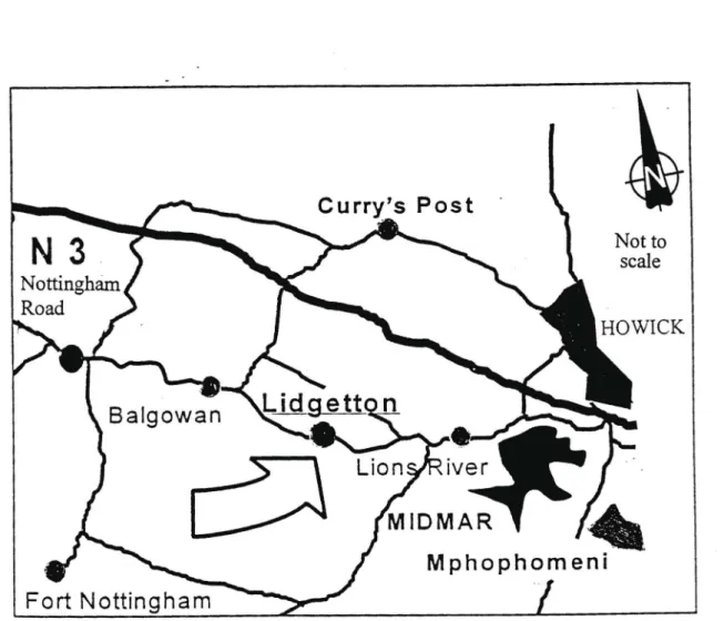
Figure 1: Location of Lidgetton West... 60
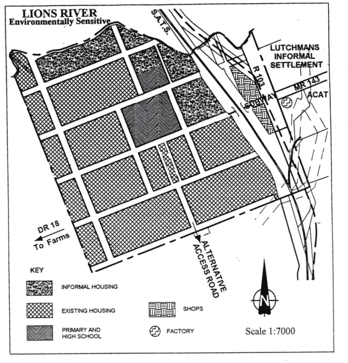
Figure 2: Generalisedplan of Lidgetton West.. 61
LIST OF ACRONYMS
The following acronyms were used in this dissertation.
ABM AMIFM ANC CAD DFA DSB FIG GIS GPS IDP
KLA
KZNPA LDO LFTA LGTA LDP LIDP LIM LIS
Area-Based Management and Development Automated mapping/facilities management African National Congress
Computer Aided Draughting Development and Facilitation Act Development and Services Board International Federation of Surveyors Geographic Information Systems Global Positioning Systems Integrated Development Plan KwaZulu Land Affairs Act
KwaZulu-NatalProvincial Administration Land Development Objective
Less Formal Township Establishment Act Local Government Transition Act
Local Development Plan
Local Integrated Development Plan Land Information Management Land Information Systems LWDF Lidgetton West Development Forum MEC
NGO NLIS
Member of the Executive Committee Non Government Organisation National Land Information System
PDA PPA PPM
PRA
RDP SDSS
KwaZulu-Natal Planning and Development Act Physical Planning Act
Participatory Planning and Management Participatory Rural Appraisal
Reconstruction and Development Programme Spatial Decision Support Systems
Chapter 1 Introduction
1.1 Background to the research
In South Africa access to and the rights to develop land was systematically denied to people ofcolour from colonial times. This situation changed with the political changes brought about by the election ofa representative national government in 1994.The African National Congress (ANC) government, recognising the difficulties of redressing the imbalances caused by the denial of access to land, implemented the Reconstruction and Development Programme (RDP) to provide housing and economic opportunity to the poor. These development programmes, together with informal development, have increased the pressure on land management processes that approve and regulate the development of land. In common with other countries, the South African Government has recognised that the present systems ofland management cannot respond to increasing pressure on natural resources and the environment as the result of changing social and economic conditions.
To enable government to govern effectively "...a predictable and honest administration of the regulatory framework" (UNCHS: 1991:6) is required. The importance of quick informed decision making,particularly at the local authority level,is implicit if the administration of a regulatory framework for local land development is to function effectively and gain widespread acceptance.
New legislation and procedures are being introduced by government to restructure local government in South Africa. Previously distinct local authorities have been combined into single entities with greatly extended areas ofjurisdiction. Since the December 2000 local authority elections,the entire country has been placed under the jurisdiction ofeither or both a local or district municipal authority.
Unfortunately the process has not recognised that current land use information is required to inform land management decision making. The exclusion of development in informal settlements from existing land management regulatory procedures further limits the availability of land use information required by local authorities for effective land management. In the view ofUNCHS (1990:4) "...a priority area for national policy action will have to be the establishment of efficient land registration and land information systems at Municipal level."
Land provides the foundation for all forms ofhuman activity but methods of managing it have not responded to changing social and economic conditions (Dale&McLaughlin: 1988). The development ofland is defined by UNCHS (1991:6) as "...the process ofturning raw land i.e.unused land or land used predominantly for rural and agricultural purposes into land used for urban purposes;principally but not exclusively for the urban poor but not excluding public industrial and commercial purposes."
This land development process involves obtaining access to the land, approval ofthe development and the ongoing regulation of its use.Itis suggested that the two themes that set the parameters of discussion of development issues are "...sustainable development and efficient equitable governance"(ibid). To ensure decision making bodies and local communities are able to make informed decisions and choices about what land development is sustainable and equitable they must be informed by current land use information.As noted by UNCHS (1990: 15),"strategic decisions are only as good as the data and the information upon which they are based. " In present land management systems decision-makers are distant from the actual land users and are not directly accountable for the consequences oftheir decisions. The availability ofland use information for local
1
level decision making will help to ensure that land management decision-makers will be more accountable than is currently the case.
1.2 Research problem
Local authority land information is based on information maintained by the cadastre which does not include information on whatthe land is actually used for. Land use information in informal areas and on land not defined by cadastral boundaries is excluded by definition and is not available to decision makers. Inmy planning position I have observed that the ongoing changes to local government ' structures during the transformation process have not always taken cognisance of the value of information collected and in some cases maintained by local authorities. Inmany cases this information has been lost as its value to land management was not properly understood.Itis against this background ofchange, informal development, delays in approving development applications and inequitable land use regulation that this study focusses on a way to provide current land use information to support land use planning decision makers.
1.3 Research objective
The objective ofthis study is to develop a framework for spatial decision support systems (SDSS) that is designed to assemble and maintain information about existing land uses. For this concept to be an effective land management tool to support local level land use planning decision making and the regulation ofland uses for all communities (formal and informal), it should accommodate the following criteria. It should firstly, provide current land use information to speed up land development applications and promote more efficient land use regulation. Secondly, assist with the integration of formal and informal land use approval and regulation systems by developing a partnership between formal and informal communities. Thirdly, establish mechanisms for maintaining current land use information and fourthly, create the linkages between local authorities and other tiers ofgovernment to add value to their information systems by providing reliable current land use information.
1.4 Research questions
There are currently no existing local authority level systems to provide current timely land use information to support the development and regulatory processes of land management. New legislation identifies local government as the level of government best suited to implement land management. The intention ofthe legislation to devolve land management and decision making to this level raises the question of how the land use information necessary to inform these structures is to be provided.
Lidgetton West, a town in the KwaZulu-Natal midlands, was used as a case study of the land management difficulties experienced by a local authority administration approving and regulating land development for both formal and informal communities. The sudden appearance of informal settlementsin Lidgetton West during 1996 resulted in a proposal to develop a low cost housing scheme to resolve the issue ofhomeless people. During the process ofengaging with the leadership ofthe informal settlements, the ratepayers of the town, and farmers associations adjacent to the town, the following two issues were highlighted. Firstly, the need for land use information and its spatial linkages with social information about the different communities in the town to inform the land management decision making processes, and secondly, the inappropriateness ofthe standards
2
being applied, or not applied, to the development and regulation ofland.Itis thesequestions which are addressed by this study.
1.5 Research methodology
To develop a system capable ofproviding current information about the actual uses taking place on land I review the theory ofdecision-making,decentralisation and the effect of institutional structures on land management and land information systems. As literature on land use information is limited, the theory on systems recording information for the use ofnatural resources and land registration is reviewed and extrapolated to develop the concept of a local level system recording land use information.The South African legal framework for land developmentand regulation is examined and as mentioned above,the small country town of Lidgetton West was used as a case study to outline the framework that could be used to support land use planning and control at the local authority level. The methodology used in the case study includes, personal observation, questionnaires and participatory management techniques.
1.6 Dissertation Structure
Chapter one has given a briefbackground of the current restructuring process oflocal government land management procedures in South Africa and outlined the need to integrate current land use information about both formal and informal development,to inform local level land development and regulatorydecision-making,into a single land management system. The research problem and object ofthe dissertation have been outlined and the chapter concludes with outlines ofwhat is discussed in the following chapters.
In chapter 2 land use planning is defined and its role in approving and regulating the development of land and its uses is examined. The participation of communities in decision-making, decentralisation and the necessity for traditional 'top-down' institutions to be adapted to allow this is then discussed.Itconcludes that for land development and regulation procedures to be effective in providing for the rapid releaseof land for sustainable development into a single accepted land management system, 'top down' management systems must be adapted to allow both informal and formal communities to participate in land development and regulatory processes.
Chapter 3 describes new and current land legislation at the national, regional and local levels that affects the approval and regulation procedures for land development and regulation. The intention ofthe new and proposed legislation is to encourage cooperative governance and involve communities in the land management process.Local authorities are seen as the most suitable level ofgovernment for this purpose. If they are to manage the co-operative governance process successfully,the need for land use information to develop local land developmentsolutions, educate communities and inform decision making is vital.
In chapter 4 an outline ofa framework which could be applied to (SDSS) is developed by reviewing LIS.The functions, features and characteristics ofa conceptual framework, capable of assembling land use information of actual land uses at the local level. for SDSS in land use planning is then described.A SDSS developed using community oriented approaches could be a valuable land management tool to integrate formal and informal communities and educate them about civic responsibilities.
3
Chapter 5 gives a briefhistory ofLidgetton West, a town in the KZN midlands used as the case study area. The structure ofthe local authority administering the area and the difficulties it experienced in equitably approving and regulating development in the formal and informal areas that comprise the town is then described. Finally the planning process and methodology used to assemble land use information to inform a housing project and define new acceptable land use development and regulation standards are discussed.
Chapter 6 concludes the dissertation and identifies the integration of formal and informal development and regulatory systems in South Africa as a priority. The effects and characteristics of informal land development on local authorities and the importance of land use information to support the rule oflaw is then outlined. Four factors which could positively influence land management when applying the outlined framework for SDSS in land use planning,and areas ofresearch which would further its development, conclude the chapter.
4
Chapter 2
LAND USE PLANNING, DECISION-MAKING, DECENTRALISATION AND INSTITUTIONAL ORGANISATION
2.1 Introduction
In this chapter I define land use planning as well as its component parts which are known as development planning and development control. I then examine the influence of the themes of decision-making, decentralisation and institutions on land useplanning and management.
The first theme examined in this chapter is theimportance ofeffective,accountable decision making in land use planning for the effective management ofthe approval and regulation of different land uses,particularly where,as in South Africa and the case study area,both formal and informal land use patterns exist.
The second is decentralising land management by devolving some decision making powers to lower levels.This is a theme evident in the new legislation which is being developedto direct land use planning policy and its role in the approval and regulation of land use and is discussed in the following chapter. Decentralising and redefining the role ofthe state is occurring in nearly all countries and local government is seen as the most appropriate level of government for land management (UNCHS: 1996:294). This is particularly relevant in KwaZulu-Natal (KZN) where land use planning has historicallybeen a top-down exercise.
The third is the role and function of institutional organisation and its effect on decision making for land use developmentand regulation. These decisions,which are bytheir nature political,are tightly controlled by land laws. The effect of laws on public bureaucracyand discretion is aptly outlined by 'de Sotho' in'The Other Path' quoted in (UNCI-IS:1991: 171)
thedistinction betweenlaws which attempt to deal with particular mattersand laws which deal with general matters; theformer inevitably heargues give rise to more and more laws andgreater andgreateradministrativediscretionas different groupsin society,including the publicbureaucracy,arguefor theirown special interests to be protected or advanced by the laws. ...Less law; law which concentrates on generalprinciplesand eschews excessivediscretion is the way forward
"Everywhere in sub-Saharan Africa the major problem remains accessto infrastructure and services, rather than security oftenure per se"(Durand-Lasserve:1997: 1).In_deve!£p'in countries"d~~ci~iQn
makers at central~~ernm~E.t an_c!.~.!y'level~L2!i!!1n~~~~~:r.?!..~.:..:.~~:!aci~g~~i~atio!1Jll~.have n00 a y sbeell.Qr~Raredto deal with: a si~nificantportion5)f t he ci.!l'-d.wellers in deye!2ping countries,at times the majority,a~exclud~~fro_m~g!!l2~gl!.larproce~~Qf.~s£~s t'2.J~!!<l~d
h~~J~~~~!rre.g2!~_seEl~~~!~~~!.~J!n!~2!:.!lo.i~tf!:''!.~JIJJQJllC~jmdamJ.[QPr.i~J~..sendce§'1 :twiOY-Thisposes major land management and planning problems,both administrative and financial,
for public authorities at all levels.
The approval and regulation of the use ofland in both the urban and rural contexts operates within / legislati ve frameworks or customary traditions which have evolved over the years. This formal legislati~.fr-?,.!p~:V...Qrkforms the basis for the land use planning component ofland management. This // iegisfative framework in South Africa has been recognised as being ineffective in providing'a
---~._.. ..-_..•.---. - - - .
__
.. - ..__.~-..---
framework to facilitate and regulate land management throughout the country. Ifland use planning is to be effective land use information should,from the local level upwards, be available to all land management policy decision-making levels. Such a land use information system that supports decision-making could be a valuable land management tool to assist with speeding up the release of land for development,informing funding applications,improving service cost recovery as well as providing the means for ongoing effective,transparent land use regulation.
There is currently nos~!eminS~t_~"b-J!~_c,~which p~ovid.:_s-,-~rg~_~~_~!~,As~~!_!:?,c~~~:ntJ~!:~~~e information for land use pt1l.nn.i,niThislack ofland use information is not peculiar to South Africa.
A;-;bserv~~fby-'i5-;I~'and Mcl.aughlin (1988:68)"...land use records throughout the world are usually poor or non-existent." A consequence of a lack of land use information is poor land managenJ.enJ:. This is manifested by difficulties in taxing property, maintaining infrastructure,' . ndertaking pro-active planning and acquiring land for public purposes (Williamson: 1992:3).
Information is also needed when changes in land use are planned or proposed (Dale and McLaughlin: 1988:69). In this dissertation I am arguing for an effectiveSDSS in land use planning to support decision making and improve land management. Alocal authority level SDSS,should be designed primarily to record and maintain a range ofcurrent land useinformation to support land use planning decision-making and regulation.
Since the political changes in South Africa brought about bythe election of representative national and local government in 1994 the difficulties facing effective land use planning and regulation have been recognised. Land development objectives (LDO), integrated development plans (IDP) and local development plans (LDP) have been seen as vehicles to speed up decision making and assist in the approval and regulation ofland uses. These processes have not been as effective as they might have been. Onecauseisjhelack.of.curren;information.aboutexistinglanduse~,J9r!nalaI!~ljnformal,.to\ inform the approval and regulation of land use developmentin the existing land use management \ system.
"In both the public and private sectors land information is a prime requisite for making decisions related to land investment,development,and management"(ibid). Records of land development applications and its actual current use is an important component ofthe land information referred to by Dale and McLaughlin (ibid).For pro-active physical planning and regulatory systems to function effectively spatial information about the land uses existing on the ground is vital ifland management decision making processes are to be properly informed.
Rapid urbanisation and the inability of present land use control systems in developing countries to regulate and accommodate the timely release ofland for development means thatthe need for creative thinking to develop new better ways to administer land use development planning has never been more urgent. The need to reform both registration and regulatory systems is implied in developing countries where 20% to 80%ofland delivery is informal(UNCHS:1996:292,Fourie: 1998:55). The regulation ofland use using the traditional'top-down' approach to spatial planning known as the land use planning approach, is no longer adequate (Pieri:1997:223). 'Top-down' approaches encourage dependency on government and ignoreslocal knowledge and inventiveness as a dynamic land use option. Governments often do not havethe resources, financial or human, to administer this approach (DeWitN.D:3). An alternative to the 'top- down'approach is the greater involvement of communities in both the spatial planning and regulation ofdifferent land uses. This will allow a role for the local knowledge and inventiveness of communities to ensure the proper use of land. The corollary ofeither approach is that it must be effective so that"...people making use of it can ach ieve results; decisions are reached relatively quickly,theyare accepted,ie they are recognised as being the product of an honest and competent decision making body, and they can be implemented"
(UNCHS: 1991:172).
Land is a fundamental resource which can only be administered properly by improving land information policies, building the necessary institutional arrangements to implement these policies as well as developing effective and efficient systems for their implementation (Dale and McLaughlin: 1988: 183). Robust information, available when required, is more important to decision- making than completeness (Pieri: 1997:223).As stated by Dale and McLaughlin (1988:2) "the value of information and the effectiveness of decision-making are directly related to the quality of the information and the manner in which it is made available." Information reduces uncertainty by helping to identify and analyse problems (ibid: I). "Decisions on sound land management are preferably made by comparing options,analysing potential benefits and impacts on various issues.
Solid and reliable information is a prerequisite for good decision making at whatever level"
(DeWitN.D.:13). "The management of land resources and the administration of land requires information to support the decisions involved" (Ezigbalike: 1996A:333). These views emphasise the importance of the effective management of land use information which directly affects the performance of land use planning which is concerned with the control and regulation of land use. 2.2 Land use planning
Land use planning is the component ofland management involved in the approval and regulation of urban and rural land use. In this section I examine broad definitions ofland use planning as well as specific definitions of its two component parts, development planning and development control.
2.2.1 Definitions ofland use planning
Land use planning is 'the systematic assessment ofland and water potential, alternatives for land use and economic and social conditions in order to select and adopt the best land-use options' (FAO: 1993, Ezigbalike:1996B:349). The White Paper on Spatial Planning and Land Use Management (2001 :92) defines land use planning as the "planning ofhuman activity to ensure that land is put to the optimal use, taking into account the different effects that land uses can have in relation to social, political, economic and environmental concerns." Ratcliffe as quoted in Dale and McLaughlin (1988:6) see planning in the urban environment as being
...a reconciliation ofsocial and economic aims, ofprivate and public objectives.
It is the allocation ofresources,particularly land, in such a manner as to obtain maximum efficiency, whilstpaying heed to the nature ofthe built environment and the welfare of the community. In this way planning is therefore the art of anticipating change, and arbitrating between the economic, social,political and physicalforces that determine the location.form, and effect ofurban development.
These three broad based definitions ofland use planning all emphasise the social aspects ofplanning.
Land use planning is separated into two different activities, development planning and development control, which operate within a legislative framework of land law.
a) Development planning
In development planning, the physical environment, including the presence or absence oftransport water and other utilities, is evaluated and a plan prepared about how different land uses and development can best be implemented in the public interest. (Dale and McLaughlin: 1988:7).This type of planning effectively stipulates the broad outline of the land use policy to be applied. These policy plans operate at various levels and are variously known as regional, sub-regional, structure, framework, development or land use plans. At the lower level, large scale zoning plans outline
specific land uses permitted in specific areas. b) Development control
Development control is the implementation of what has been decided in the outline or policy plan (ibid). In the event of there being no planning framework or zoning, control,the subdivision and development of land is controlled in terms of conditions of title and whatever national,regional or local legislative frameworks exist to authorise and regulate the development ofland and resources.
I use the term 'land use planning'to include both development planning and development control.
Although there are differences between the two, both deal with the approval and regulation ofland use. From the above outline ofland use planning the need for land use information about the land to be planned and regulated is implicit ifdecision-making processes are to be carried out effectively and timeously. In chapter 4,I will outline a framework for SDSS which can be designed to provide the necessary land use information at the local authority level to support both community and local authority level decision- making about the planning and regulation ofland use. This system could also form the basis of a more efficient land administration and service cost recovery for local authorities.Itwill also add value to existing distributed LIS provided the necessary linkages and exchange standards are developed.The efficacy of local authority land use planning and land management is directly affected by the processes of decision-making, decentralisation and the institutions needed to carry out and administer the land management policy.These themes are examined in the following sections.
2.3 Decision-making
For land use planning to be effective I am arguing that decision-making about land use rights needs to take place close to and be accessible to communities. I will show that provided certain conditions are met accountable, low level decision-making for land development and regulation has a crucial role to play in integrating formal and informal development.
Marslows hierarchy ofneeds concept, used by Pieri (1997 :221 ) is useful to decision- making in land use planning and management. The maintaining of higher order needs, such as collective responsibility for ensuring everyday behaviour, is only possible when lower basic needs for food, shelter, stability and health have been satisfied (ibid:224/224). This is also true in the context ofthe economic development ofland. For a community to fulfill their responsibilities their basic needs must be satisfied. In the case study,presented in chapter 5, it was only possible for this to happen as the local authority was in a position to provide health clinic facilities and make provision for a low-level water supply to satisfy some of the community's basic needs. This stimulated wider community interest in developing an acceptable solution to improving poor existing social and housing conditions.
The presence of both informal and formal land use patterns in South Africa,as exists in the case study area, indicate, that "...a means of intervention which ensures the development of synergy between formal and informal channels ofland and housing development" (Durand- Lasserve: 1997:8) needs to be found. I am arguing that by involving communities in assisting with the collection and maintenance of land use information,a synergy between the formal and informal channels of land and housing development can be developed. A community actively involved in assemblingand maintaining land use information will be able to provide input about the criteria to be applied in land use regulation as well as decisions about future land use development within the limits of broader policy. Any decision outside or in conflict with the limits ofthe broad land use policy will be subject to ratification by existing statutory authorities.Provided vertical links are developed the land use
information collected and maintained by the community could ultimately be usedto inform higher level statutory authorities land use decision processes.
As noted by Ezigbalike (1996B:349) "The awarenessof the role of information in general decision making is very low in Africa. Most decisions are made on the basis of interest groups and political expediency, rather than on objective decision analysis." Ezigbalike goes on to say that "what is required isthe introduction of low-level,community-initiated planning,with informed decision- making. With that, information management will develop tosupport decision-making processes"
(ibid:352). From my experiences ofthe land use planning process this lack of awareness ofthe role of information also pertains in South Africa in both the rural and urban contexts. Local populations havethe wrong impression that the actual work is the onlyimportant thing as the information and decisions to implement projects are not visible (ibid:350,351).lf"...possible, the land rights database and registration system should be compiled at the same time as land use planning, but if resources are limited.... priority should be given to information requirements for land use planning over 'cadastral' arrangements" (ibid:349). This statement emphasises the importance of land use information to land use decision-making if the approvals and regulation of the different economic uses of land are to be speeded up.
"As the cost ofcollecting, validating and using data and information,... imposesstrong limitations on the quantity of information..." (Pieri: 1997:225) only information relating to achieving the objectives identified should be collected. The emphasis should be on timely, demand-driven information resulting in qualitative data and information rather than comprehensiveness. These arguments hold true for land use information.Costs are an inhibiting factor especially if policy makers cannot see any benefits being realised from the data. The reasons for acquiring information must be clear and conform to local authorities responsibility to speed up land use development approvals and provide for the efficient regulation of land uses. The "...elusive measures such as human values,attitudes, beliefs,judgement,trust, and understanding"(B err y:1993:76) need to be included in the decision-making environment. Three inputs into this environment are,"...the scientific, the social, and the legal components of society"(ibid:75). In the land use decision-making environment there is often no balance between the technical and socially acceptable sectors."A technical solution often meets social acceptance in a loggerhead. The result is an injunction, and the legal sector is called to make the management decision"(ibid:76).For decision making close to the community to be effective a participatory approach which"...facilitates the integration ofthe social and institutional dimensions ofland management with the technical" (Fourie: 1998:9) is required. The idea that"social as well as economic effects, in the same wayas environmental effects, should be considered in determining planning applications"(Wai- Chung Lai: 1998:272) supports this view.
"Participatory decision making has two mainthrusts:consensu sbuilding and conflict resolution.
Consensus building involves technologically driven communication and occurs during the alternative formation phase ofthe decision-makingprocess"(Berry: 1993:77).I am arguing for a participatory planning and management (PPM) approach that integrates the social and technical dimensions ofdata to inform decision making.By using this approach different possible outcomes that could arisecould be used to focus discussion on possible acceptable solutions and resolvepotential conflicts arising from different proposed or actual land uses.
2.3.1 Participatory planning and management (PPM)
Participation isviewed "...as the involvement of the projects beneficiaries in decision-making, implementation and evaluation."(Garcia-Zamor:1985:3) There are two types of participatory planning and management (PP M), firstly the type that induces participation and secondly, the type that merely requests or encourages suggestions. The first can be encouragedby formal committees
who encourage local communities to provide input into projects (ibid).A form of PPM is the participatory rural appraisal (PRA) which is described as a technique that"...operates on the premise that problems in ... areas are endemic and ongoing."(Fourie& van Gysen: 1996:355) The PRA process is more than a consultative exercise."Instead ofoutside professionals (specialists) obtaining information about a local area by using field workers,then fitting this information into an official land management plan of action ..." (ibid) in which communities can participate, the planning initiative is given by facilitators to the locals.Encouragement to use the knowledge oflocal practises often results in the development of innovative andsustainable solutions.The use ofPRA"...and the information collected, can then have a direct impact on the ability of a local community to manage its problems, including land management issues" (ibid:356).
The objectives of PPM management listed by Garcia-Zamor (1985:5-9) are that it firstly,promotes integration, secondly,improves performance and the acceptance of performance criteria, thirdly, deals with and responds to community needs and problems,fourthly,results in a higher quality product, fifthly,improves the quality and quantity of information, and sixthly,permits greater use oflocal human resources. If the six objectives outlined aboveare to be achieved a characteristicof a SDSS for which the framework is outlined should be that PPM techniques are used in the assem bly and maintenance of land use information which will be used to inform decision-making.
IfPPM is to be used effectively four major obstacles need to be addressed. These are the dominance ofone group over others, lack of interest from participants, lack oftime and restrictions from present structures and systems (ibid). My experience in the case study is that restrictions from present structures and systems and the dominance of the controlling informal group present the greatest obstacles to the use of community oriented approaches.
Land resources management decisions at all levels are the direct results of a negotiation process between different stakeholders involved in various ways (directly and indirectly). The essence of negotiation is that the interests of all stakeholders are fairlydiscussedwithout preconceivedbias. This implies,firstly, that the stakeholdershaveto be identified,secondly, thatconditions are present for them to effectively participateas genuinepartners, and thirdly that all are fully informed on the issues at stake(DeWit:ND.:12).
I argue that these implications hold true for land management decision-making. If the use of PPM techniques are to be successful the "outcomes of local negotiation processes must be accepted by hierarchical higher bodies,...within a given set of rules established at..."(ibid)a higher level.
"Each group ofstakeholders assess their needs on the basis of perceptions and understanding ofthe land use issues and the availability of information." (Pieri:1997:224) This approach relies on
"...building partnerships for the development and delivery of innovative technologies drawing upon an interactive establishment of major'stakeholders' needs..."(ibid:225).Pieri goes on to note that
" ...only critical information, ie information that most directly (efficiently) relates to the issue in hand is needed,..." (ibid). By involving the communities in the case study (see chapter 5) in the process ofgathering data they were able to assistwith firstly,the prioritising of needs,secondly facilitating the process of integrating formal and informal communities,thirdly developingan awareness of conflicting land uses and resolution mechanisms, fourthly, revising infrastructure and service standards and land use regulations not adaptive to the needs of the different communities.This approach is foreign to the present methods used by most local authorities.Ifnew approaches to land management are to be developed the role of the local authority must be adapted to use PPM techniques.
2.4 Decentralisation
Top level or central decision makers tend to need quantitative information ratherthan the timely demand driven qualitative information and semi-quantitative information needs of local decision makers for action programmes,conflict resolution and consensus building.These two approaches to information needs should not be seen"...as competitive but as complementary,and implemented within the broader frameworkof a comprehensive and decentralized information system on land related issues"(ibid:225). At the local authority level the emphasis should be on knowledge sharing and demand driven information required to inform and speed up land use development approvals and the efficiency of land use regulation.
As the human population increases ever increasing pressure is being placed on land,resulting in increasing " ...competition and conflicts to access and to use this finite life supporting resource"
(ibid:223). The development of informal settlements which house both the rural and urban poor are physical manifestations ofthis competition and conflict over the right to use land. As stated by Pieri (ibid: 223)"there is a need to move from a prescriptiveapproach towardsan integrated approach to the physical land use planning and the social and institutional dimensions ofland management" Some ofthe problems facing government and traditional>top down= land use planning are a result ofthe following;
land use planning is not demand driven and is largely imposed by governments which often lack the funds and human capacity to implement plans (De WitN.D.:5);
it is neither quick nor flexible and "land use or planning decisions take an enormously long time"(Fourie:98:8);
land use decision-making is centralised and there is no local accountability for decisions taken;
.. "overlapping responsibilities can also jeopardise clear decision making"(DeWitN.D:5);
.. the situation on the ground is not taken into account because of a paucity of' de facto'land use information ;
good governance is undermined if different types of land management plans prepared at government expense are not given any legal status and cannot be implemented.
'Decentralisation means the devolution of powers, functions, resources and administrative programmes from central government to regional local authorities and even to lower tiers at the community level' (UNCHS: 1996:294, Fourie:98:9). Most countries are " ...decentralizing and redefining the role ofthe State,partly due to the fact that so manycentral land management policies have not met expectations... Such decentralisation should allow the creation of better vertical co-ordination between'bottom up' information and local interest and'top-down' information and policy guidance which can harmonize overall national development policy with local programs"
(Fourie:1998:9,10) In South Africa"in the long term,the vision is for a decentralisation offunctions to the local government level" (White Paper on SA Land Policy:1997:101). The acceptance of decentralisation is alsoevident in the Durban Metro Council. The Council"...is presentlyconsidering a model ofArea-Based Management and Development (ABM) that seeks to combine the advantages of centralisation and those of substantive decentralisation" (Hindson:200 1).
To inform higher authorities of both the negotiation process and the approval oflocally agreed land useproposals,a detailed record ofexisting land uses,local knowledge andexisting and possible future conflicting land uses is required. "For land registration and/orrecordalto work in Africa the system itself should become more accessible, both in terms of location, cost and user
friendliness"(Fourie:1998: 11).I am arguing that this statement could be applied to a SDSS, capable ofassembling and maintaining land use information ifit is to gain widespread local acceptance.Itwill be decentralisedand supported at both the local and regional levels with possible future linkages to the National Land Information System (NLIS). By involving affected communities in assisting with the assembly ofland use informationI am arguing that land use management systems will be more easily accessible to communities requiring information to inform their opinions and assume civic responsibilities. The process will also serve to inform locals of the governments broad land management policy decisions and plans.To enable such a scenario to develop the issue of how institutional organisations can be adapted to accommodate some form of decentralised land use management system is critical.
2.5 Institutionalorganisation
"The management of urban land involves highly political decisions about scarce resources and however much, in theory, it is desirable that such decisions are taken on 'rational,' 'obj ect ive' grounds, reality will break in on theory and in practice decisions will be'messy,' a compound ofthe rational and objective and the 'irrational' and 'subjective'" (UNCHS: 1991 :84). Institutions need to be adapted to developand implement effective land information policies and systems to optimise land management (Dale and McLaughlin: 1988:183,184).In this section a definition ofinstitutions as well as principles identified in literature for enhancing institutional management frameworks functions and responsibi lities will be reviewed. The functions ofnational, regional and local level institutions will then be examined.
2.5.1 Institutions
Dale and McLaughlin (1988:183) usethe term 'institution' to refer" ...to the established laws and customs and the administrative structure needed to support them. Itincludes various aspects of organizational behaviour that influence and control the freedom ofthe individual, particularly in the context ofwhat is allowed to be done with the land."DeWit(N.D.:9)says that "institutions deal with co-ordination, implementation, regulation, monitoring, conflict resolution, negotiation of land resources use and management" .Institutional rather than technical problems are considered by De Wit to be the most serious difficulty in resource management.
Land development decisions and land use regulation play a direct role in resource allocation and approval. Approvals of land use are regulated by the conditions of approval and/or zoning.The decisions,taken after institutions and institutional procedures to adjudicate land use issues have been followed, can have wide, varied and unpredictable effects. These decisions allocate land and resources,actions which affect the rich and influential as well as the poor and non-influential. The fear of interest groups and communities to changing established procedures ensures that any changes in institutional frameworks have to be provided for by constituent law.This results in institutional problems being far more intractable than technical ones. Land management institutionsneed to be adapted to accommodate a system capable of recording and maintaining land use information to support decision makers. The functional adaption, development of vertical and horizontal partnerships,and empowerment ofinstitutions to fulfill their roles are considered to be vital elements for the enhancing of institutional resource management frameworks (DeWit:N.D.:9). In my experience these elements are also critical for local authorities if they, as proposed by the new land legislation, are to carry out their envisaged role ofco-operative and participatory land management.
UNCHS (199 I:84,85) says that if institutionalframeworks providing for >top-down= decision making are to be redefined the following principles should be provided for;
(a) an input ofinformation and ideas from all relevant bodies and persons to the decision-maker:
(b) a transparency of the criteria to be used by the decision makers;
(c) the delegation of decision making in non-policy areas to a level as close to the consumers as possible;
(d) audit and review of the process to ensure its effectiveness and efficiency.
A feature ofany'top-down' institution adapting itselfto decentralised decision making should be the establishment of a SDSS in land use planning to provide the relevant information to support delegated decision-making. Similarly any institution establishing a SDSS will have to simultaneously adapt its procedures to accommodate it if it is to function effectively. In most countries there are 3 levels of institutions all of which have concerns with land management.
2.5.2Institutional levels ofland management and land use planning
In South Africa,as in most countries,government institutions exist at the national, regional and local levels. All three levels have a stake in land management and policies that have direct effects on the viability of a SDSS. In this section the respective responsibilities of each level are briefly outlined.
a) National levelfunctions
A function of central governments is to " ...define and formulate national policies and provide the institutional and legal frameworks for decentralization"(UNCHS: 1996:294). They must also ensure that local authorities have the necessary resources to finance local urban land programmes (ibid:295).
"A recurring problem in other countries has been the inadequacy of survey and land tenure records and a lack ofinformation on what existson the ground and how land is utilised"(White Paper on SA Land Policy: 1997: 106). Toward this end aNLIS isproposed to coordinate land information in South Africa (ibid: 108).The NUS should form the nationalbasis for the land management component of development planning and land regulation.
b) Regional level functions
Forthe regional level to function its rights, obligations and accountability forresponses to local needs must be clear.Jt should provide information,technical support and feedback to national level. It has an important role in maintaining public infrastructure,including information infrastructure at the regional level.
c) Local level functions
For the local level to function effectively a coherent legal framework that legally defines their rights and obligations is necessary. This is especially important in South Africa where local government has been restructured into two levels,district and local municipalities. The practicalities of this
" ...bearing in mind the costs of running the structures,the subsidiarity principle, the problems that have been experienced with provincial government, and potential competition between structures"(Goldman:2001)have still to be established.
The functions oflocallevel committees is to prioritise local needs, select options and provide the link to higher level institutions (De WitN.D.:9-11). "Local level management committees reflecting the existing community social organisation and their leadershipform the basis ofthis activity" (ibid: 11) and will form links to either the local authority,or in rural areas the district council. The political desire by central and local governments, social acceptance by stakeholders, technical and economic viability,and sustainability are all principles listed by De Wit(N.D.:6,7) as important in negotiating
future land resource management decisions.I am arguing that these principles are equally applicable to successfully outlining the framework for a SDSS in land use planning at the local authority level.
Local authorities are the level of government closest to communities and are in a position to allow community participation in land management. In the case study both formal recorded settlement and informal unrecorded settlement were involved and problems approving and regulating land uses in the town arose. The problems arose from the refusal ofland development applications in the formal areas ofthe town that did not comply with the existing formal land use development policy,while ignoring, or applying different less onerous development standards, in the informal areas. The problem of integrating the formal and informal communitiesin a manner that would enable the local authority to administer and regulate land use in the town equitablyneeded to be addressed."The failure to adopt,at all levels, appropriate rural and urban land management practices remains a primary cause of inequity and poverty"(Fourie: 1998:12,Durand- Lasserve; :997). Local Authorities should therefore adopt different land management approaches and " ...find appropriate ways to encourage communities to participate in shared land management oftheir area"(Davies; 1998: 45).
The WhitePaperQl1~S~mJtu:\fri~~l!!11andPolicy(-l997(17)states thatinruralareas"the[~j~_aserious need for a new land1.!s~plannjngal1da<t(~V~~!QRm~Q!:J~lanning.and.~C.QntroLsystenu:esp-Qll~iY~Jothe I~f1?e~l?le..." and that "c<;,<:>rdinati()J:L9Lillm~rtments amU~YJ<ls_QLgQY.~mment, and sound working arrangements.betweennational,provinciaLandlocalleYSl_L(l<:lJ:l1511}_s!~~'!!i<:l~~..!~_Jllf.l<:l.'!!!l_~l1tal to the su~cess~QfJandpQlicy':':'.(ibid:95).Itgoes on to say that "a monitoring and evaluation system that can track the progress of land policy measures, and that can provide timeous feedback to managers and the public, is a key element in ensuring that policy measures are able to achieve their intended goals" (ibid). One of the issues that a land policy needs to deal with is"a system ofland
11lil_m~gementwhichwill supportsusQli~~abJeJ.andlli>~e_PJ!ttt:<rnsandraQidJ~l!Q!el~~sefor develoRment"
(ibid:7).-Cam argulng~~fflad'orsuch a land management system to develop at the local level,the existing traditional'top-down'regional and local institutions will have to be adapted. At the local levelalandmaJlagementsys!~!1l~sJ:!.ouJQ;jl1V~J~~J2ca!.s:_<:l~'I1~'I1.1.-!.l1iti~sil1tll~.£oJ!~~!i5)~~~~1.~ J!l~i~~~e.J.1.ll:I~?_e of land use information which includes re<:or.dingJll~.~<;leJacto:..andJegaJ_rjglltsJQJ~IQP_tLJ1Y;Jte_ a~e...:>~i.~I~ !~_t.h~ ~2..m111.1.!!lij:ies; encourage accountability and..employ_pa[1:ic:ipatQ..JY.JTI§.thQ9.§j:g.
establish appropriate land use regulation and devel()prp.ent.s!lln~cl.a~cis.:_
2.6 Conclusion
I have shown that lower level decision making, decentralisation and the redefining of institutions are crucial ifa SDSS,capable of supporting a restructuring land management system to support the rapid release of land for sustainable development,are to be successfully implemented by local authorities. Traditional planning and regulation measures are becoming less efficient and new planning models to improve land use regulation administration and service delivery are required.
Neither the formal private land markets orthe public authorities can meet the urban land demand of low income groups.Therefore,the informal land market fills the gap and providesaccess to land without public control or monitoring by public authorities (Durand-Lasserve: 1997:4,5).For these reasons the "integration and regularisation of irregular settlements would appearto be the first step towards a new form of managing urban development" (ibid:5). "Empiricalstudies...underline that there is no integration of irregular settlements without public authority intervention" (ibid:8). I have shown that the processes ofdecision-making, decentralisation and the roles of institutions have to be adapted if a low-level SDSS capable of providing land use information to allow for faster more efficient economic development and regulation of land and assisting in integrating informal land developments is to be successful. To enable a SDSS to function effectively institutions will have to adapt to allow decentralisation and low level decision-making. In the next chapter I outline existing and proposed legislation which is reforming the present'top-down' land management approach to
land use approval and regulation. In chapter 4 the framework for a SDSS to provide land use information to support the co-operative governance concept outlined by the new land legislation in South Africa is described.
Chapter 3
PRESENT LEGAL FRAMEWORK FOR DEVELOPING LAND IN RURAL AREAS AND TOWNS IN SOUTH AFRICA
3.1 Introduction
In this chapter legislation at all levels ofgovernment relevant to the development ofland and how it affects the development and regulation process for different land uses is examined. The legislation is discussed from the perspective ofdevelopment in the KwaZulu-Natal region where the case study area is situated.Itis acknowledged thatthe list oflegislation is by no means complete. The legislation selected gives an indication ofthe complexities involved in the approval and regulation ofland use development in South Africa during this period ofland reform. Much ofthe legislation emphasises community involvement in decision-making.I will show how the importance ofland use information to land use approval and regulation procedures is implicit if the recommended land use planning procedures are to function efficiently. For the purpose of this research land use is defined as the different uses of land in both urban and rural areas for the purpose of human settlement and economic activity.
"The apartheid policy of the Nationalist government- as applied to access to land and land tenure- resulted in a vast, legislative labyrinth built upon a massive skein ofracial zones which wound amid the corridors of scores of different national and local administrative authorities" (Rutsch &
Jenkin :200 1:1). The present legal framework for approving and regulating different land uses in South Africa includes new land laws which are being developed to reform the previous labyrinth of laws by their repeal or partial and suspensive repeal. As Rutsch and Jenkin (200 IB:22) go on to say;
there exists an extraordinary and complex situation in regard to the laws applicable to land, land use and land development. The Constitution Act 108:1993 also provided that, as at the date the constitution came into operation, all existing laws inforce and effect in any area ofthe country remain inforce and effect until repeal or amendment of such laws by the "competent authority" (ibid .section 4:22)The effect ofthis, coupled with the re-integration ofthe TEVCI states and ''homelands'' back into the national territory, has been a mixture of national statutes, provincial ordinances, "independent" state and ''homeland "laws being applicable in regard to land, land use and land development matters throughout the country.
In this chapter I will show that the legislative framework being developed for land use and land development is in accord with the proposals for participatory and decentralised local governance outlined in chapter 2. For these proposals to function effectively current land use information will be required to support pro-active land use decision-making atthe local level. The design and features of a SDSS capable of providing this land use information will be discussed in chapter 4.
3.2 National legislation
"The Constitution Act, 1993 (Act 200 of 1993) and its accompanying Schedules provided that land
1Transkei,Bophutatswana, Venda, Ciskei
matters and legislative powers regarding land matters are a competence ofthe national government and the provincialgovernments have legislativeand executive competence regarding a wide variety ofland use matters such as agriculture,environment,soil conservation,housing,regional planning and urban and rural development." (Rutsch& Jenkin:200 IB:21).The Constitution ofthe Republic ofSouth Africa (Act 108 of 1996) retains the functional areas ofconcurrent national and provincial legislative competence in land matters.
In this section the national legislation which affects developmentapproval procedures for different land uses,and the regulation of land uses is examined.Itshould be notedthat the process of land subdivision is included in land development procedures as control of the subdivision of land, and compliance with the conditions ofestablishmentimposed,is a widely used method ofcontrolling and regulating land development.
3.2.1 Development and Facilitation Act (No. 67of1995) (DFA)
As stated earlier there is a need to reform the existing complexities ofthe existing legal environment for land usedevelopment and regulation .
...the urgent needfor land to beprovided and developed far more swiftly than is normally the case using existing legislationhas been matchedby a concurrent urgent needfor legislationwhich can"fast-trackllthroughtechnicalandcomp lex land procedures without detracting from security oftenureand sound planning (Rutsch& Jenkin:2001B:22).
An example which illustrates the complexity of land use and planning is that "...in the Durban Functional Region,there are no less than 11 separate statutes which immediately come to mind as being applicable to any particular land area in regard to land use and planning - dependent upon just where that piece ofland is situate" (Rutsch & Jenkin:200 1C: 1). The Development and Facilitation Act was an attempt to address this problem by providing nationally applicable norms,standards and procedures to land development.
The general principles of this act apply throughoutthe country to the actions of both the state and regional and local government but exist in parallel to provincial and other existing laws applicable to land development. Itprovides broad guidelines for the administration of any spatial zoning, transport or the like by any competent authority dealing with subdivision,use and planning ofland.
The generalprinciples for land development outlined in the Act include;
~ providing for all urban and rural development including formal and informal
~ discouraging illegal occupation ofland with due recognition ofany informal development processes
~ promoting efficient integrated land development by optimising existing resources, providing diverse combinations of sustainable land uses, correcting historically distorted spatial patterns of settlement
~ encouraging communities affected by land development to participate in the process
~ developing the capacity of disadvantaged communities
~ policy,administrative practice and law that promotes speedy land development
~ co-ordination of interest of all sectors affected by land development
The Act also provides for the establishment ofa Development Planning Committee and Development Tribunals to advise the minister and consider land development applications and conditions of establishment, respectively. Provision is also made for the preparation of Land Development
Objectives (LDO) relating to transport,health,bulk infrastructure,density ofsettlements ,land use and optimum and sustained utilisation of resources. LDO's prevail over any plan defined in section
1 of the Physical Planning Act No. 125 of 1991.
Although this Act came into effect in 1995 it could not be used until the development tribunals were appointed in 1998. Since the establishment of the tribunals it has seen only limited use in development applications. The major drawback in using the Act is that all procedures,problems and hurdles faced by a developmentapplication must be addressedbefore the application is submitted (personal communication from a Land Surveyor). Often the detailed land use information required to motivate the application is not readily available. This involves the applicants incurring high costs without having any prior indication ofwhether the application has any chance ofsuccess.This lack of approval in principle has resulted in many land development practitioners preferring to use the better known Less Formal Township Establishment Act when applying for development approval.
3.2.2 Less Formal Township Establishment Act (No. 113 of 1991) (LFTEA)
This Act was enacted to enable lower servicing standards to be used when establishing residential townships.Itprovides for. "...shortened procedures for the designation,provision and development ofland and the establishment ofTownships for less formal forms ofresidential settlement; to regulate the use ofland by tribal communities for communal forms of residential settlement" (Less Formal Township Establishment Act: 113 of 1991). It allows the owner of the land to apply for land to be designated for less formal settlement subject to specified conditions. As with the DFA it also confers the right to suspend registered servitudes and other restrictive conditions if required subject to compensation ifnecessary. Settlement ofland is permitted after a general plan has been prepared by a land surveyor. Criteria for the settlement of land under traditional communal tenure are also provided subject to the preparation of a general plan by a land surveyor.
Initially local authorities and developers were reluctant to use the DFA and its new procedures. To encourage its use the Government introduced a system which loads the points awarded to funding applications using the DFA as the routeto establish low cost housing developments. As with the DFA there is often a lack ofland use information to inform development applications to be made in terms of the LFTEA.
3.2.3 Local Government Transitional Act (No.209 of1993) (LGTA)
This Act providedfor the interim revision of the structure of local government and established Provincial Committees for this purpose.The Act provided for the establishment of;
a) forums to negotiate the restructuring of local government, b) transitional local government structures,
c) the Local Government Demarcation Boards,
as well as the appointment and election of transitional local councils in the interim phase of restructuring local government.
The Act also required local authorities to prepare Integrated Development Plans (IDP's) for their areas. Funding assistance for this exercise in the case study area, which is outlined in chapter 5, was provided by the Kwa-Zulu Natal Provincial Administration (KZNPA).
3.2.4 Local Government Municipal Structures Act (No. 117 of1998)
This Act defines three types ofmunicipalities and a range ofslightly different executive systems. The