isprs archives XLII 4 W3 43 2017
Teks penuh
Gambar


Garis besar
Dokumen terkait
Since Autodesk Revit, as the typical BIM software, provides the platform for parametric modelling and information management, an API plugin, able to automatically create
Once a laser scanning project needs to be georeferenced, Trimble SX10 scanning total station presents the advantage of requiring only one device in the field, whether georeferencing
As proved by the historical overview of the dome surveys, it is worthy to note that a survey characterized by high density and adequate precision was not available as well as a
Responding to these principles as well as to the Charter on the Preservation of Digital heritage (Vancouver, 2003), this multidisciplinary project, which involves archaeologists,
This contribution provides an overview of various photogrammetric measurement techniques in minimally invasive surgery and presents a self-developed prototypical
Our algorithm is based on the GSP (Generalized Sequence Pattern) (Balke W. This goal will be accomplished by three actions: a) analyzing the sequences of
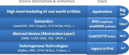
The module developed in this research permits developers connect mobile devices with FIWARE Orion Context Broker to collect information from the sensors of Android
The International Archives of the Photogrammetry, Remote Sensing and Spatial Information Sciences, Volume XLII-3/W3, 2017 Frontiers in Spectral imaging and 3D Technologies
