A Review Identification of Avian Influenza Environmental Risk Factor using Remote Sensing Image and GIS.
Teks penuh
Gambar
Dokumen terkait
In order to simulate a satellite remote sensing system accurately, the signature rendering equation implemented in a simulation environment should include terms to describe the radiance
Water quality identification based on remote sensing image in industrial waste disposal using convolutional neural networks Prasetya Widiharso a,1, Aji Prasetya Wibawa a,2,* , Anik
Author keywords leapfrog sprawl remote sensing and GIS Strip sprawl transportation urban sprawl Indexed keywords Engineering controlled terms: Geographic information systems Land
Figure 11 The hazard degree map for all sub- basins and the roads within the watershed Conclusion In the present study, GIS-based morphometry and remote sensing data were used to map
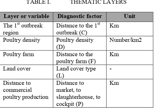
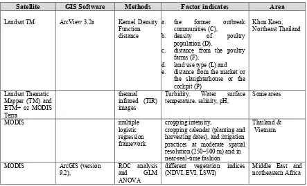
In study A, the objective was to study epidemiology and identification risk factors associated with the occurrence of avian influenza in poultry farms in Northern Thailand.. The study
Conclusion The present study adopted remote sensing data, GIS tool, and RUSLE model to estimate the soil loss with the severity and variability in the Kulfo river catchment, Rift
The following objectives were set: To review the progress and identify gaps in remote sensing applications in soil erosion mapping using multispectral remotely sensed data To
CERTIFICATION OF APPROVAL DEFORESTATION ANALYSIS USING REMOTE SENSING by Nebyu Yonas Sutri A project dissertation submitted to the Electrical and Electronics Engineering Programme
