PROCEEDINGS OF THE INTERNATIONAL CONFERENCE ON UNIVERSITY-COMMUNITY ENGAGEMENT SURABAYA –INDONESIA,2-5AUGUST 2016 1081
Mapping Asset Based Community Development
(ABCD) using Geographic Information System
(GIS) and Remote Sensing Data
I
LHAMA
LIMUDDINFaculty of Engineering, Hasanuddin Universiy Makassar [email protected]
S
ERLIAHN
URFaculty of Adab and Humanity, UIN Alauddin Makassar [email protected]
Abstract: As one of the three pillars of university building principles, university-community engagement (UCE) programs are considered signify-cant to have a direct impact to community compared to teaching and research aspects. One tool of assessing and designing UCE programs for community development is what so called Asset Based Community Develop-ment (ABCD). ABCD is a methodology for the sustainable developDevelop-ment of communities based on their strengths and potentials. Digital mapping technology has enabled us to map any given area of our earth for any specific purposes. Geographic Information System (GIS) is a computer-based tool that analyzes, stores, manipulates and visualizes geographic information on a map, while remote sensing is a growing technology that enable us to integrate the spatial data from airborne and satellite images into the GIS. There are some key assets in any given community: individuals, associations, institutions, physical assets financial, spiritual, and cultural. Using the digital technology of GIS and remote sensing data, all these key assets can be inventoried and analyzed for further planning and program designs. Our research paper explores the use of GIS and high resolution remote sensing data in mapping the key assets of ABCD in our pilot student UIN Alauddin community service programs (KKN) in Enrekang, while Bantaeng Districts of South Sulawesi Province is the target area of Hasanuddin University KKN students.
1082 PROCEEDINGS OF THE INTERNATIONAL CONFERENCE ON UNIVERSITY-COMMUNITY ENGAGEMENT SURABAYA –INDONESIA,2-5AUGUST 2016
Introduction
It is undeniable fact that Indonesia is a populous nation in the world. With an approximate of 250 million population, it is now being the fourth rank in the world behind China, United States and India. Unfortunately these large population are unevenly distributed in its 13.500 islands. Two third of the population dwell in rural areas which associated with low income, low level of education, even can be lack of basic infrastructure and considered marginal. This kind of community is considered at risk in sustaining their life. To survive for long they need basic need, especially education to motivate their living. Many of the local communities migrate to urban areas which in turn due to the low level of education, they will create social problems in urban areas (Nur, 2015).
Having this reason, Indonesian government has encouraged people to migrate to certain unpopulated islands known as transmigration programs. Nevertheless this program has not solved the population problem. People are then encouraged to stay in their village areas and government have tried to support them with programs that can empower their community. With The President Jokowi new government, village ministry has been purposely established to focus the village development along with existing transmigration and some Indonesian developing areas. With the government regulation on village empowerment, each village will be provided 1 billion rupiah to support the development in the village. Problems have been identified related to that policy. It is a fact that not all village community understand what to do and how to run a development program. Many aspects of lives are difficult to fulfill due to the lack of education especially to a grass root level of community, the individual, and people with less income. The lack of education has made the local community difficult to understand their needs and in turn cannot solve their own problems. This usually ends up that the local community will seek for help from larger scope of community. Some communities need directions on how to build a strong community that can sustain themselves.
PROCEEDINGS OF THE INTERNATIONAL CONFERENCE ON UNIVERSITY-COMMUNITY ENGAGEMENT SURABAYA –INDONESIA,2-5AUGUST 2016 1083 ‘community’ as applied has important core meaning attributes, but fuzzy
boundaries in terms of exactly who is or is not included (Onyx, 2008). In approaching the exploration of this paper, below are the description of the 4 keywords involved KKN, GIS, Remote sensing and ABCD approach.
Kuliah Kerja Nyata (KKN)
University has functioned as the support for the community. Higher education has three functions: teaching, research, and community service/engagement. There are three main types of university engagement and partnership with the community: (1) academic knowledge transfer; (2) university continuing education; and (3) community based research and service learning. This is well known as the term of Tri Dharma Perguruan
Tinggi or the pillars of university role. This three pillars can be performed by
the university components of lecturer and students. One major program linking the community and lecturers with students’ role in the community is what so called KKN. KKN is an acronym that stands as Kuliah Kerja Nyata. Literally translated as Learning and Working in a real world or community. In English several terms has been used to describe this kind of programs like Student Community Service, Field Work Experience, Service Learning Program, Student Service program or some use the word Community Outreach Program. In this term of reference we adopt the Student Service Program (SSP) as an English term to describe what KKN in Indonesian. This paper will continue using the term of KKN.
KKN is a form of embodiment of the concept of Tri Dharma. Tri Dharma is a concept in Higher Education, where the University must perform activities of research, teaching and community service. This KKN is a form of activity that blends the Education, Research, and Community Service, in a single activity. KKN is an integral part of higher education curricula of undergraduate studies (S1). KKN does not stand alone and cannot be separated from the purpose and content of higher education. KKN emphasizes aspects of learning experiences that connect academic concepts with the reality of people's lives. This program reflects the theoretical knowledge synergized with experience in the real community and be able to finalize the student's personality and foster self-confidence in social life.
1084 PROCEEDINGS OF THE INTERNATIONAL CONFERENCE ON UNIVERSITY-COMMUNITY ENGAGEMENT SURABAYA –INDONESIA,2-5AUGUST 2016
programs grew as a response to the strong pressure of globalization in societies in Indonesia. At the moment the service learning activities better known as KKN - Pembelajaran Pemberdayaan Masyarakat, (KKN-PPM) translated as KKN Learning for Community Empowerment). The development of KKN PPM was marked by a change of paradigm, namely from the paradigm of development (development) into empowerment (empowerment), so that the implementation of the Program KKN-PPM become more contextual.
In connection with the adoption of the paradigm of empowerment, then KKN was carried out by the principle of co-creation (the idea of the various parties related), co-financing (support from various parties related), flexibility (adapting to the situation of environmental conditions and needs of government, business partners and the community in the development process in the area), sustainability (activities should generate development / sustainable development in the center of the target community) and community-based research services (each activity based / implemented based on results of scientific studies).
In recent years, many universities in Indonesia have made this subject as a compulsory subject, because the learning activities especially beneficial to students, colleges, communities and governments. It is also driven by the Ministry of Education and Culture through the Directorate of Higher Education that facilitate their training on KKN programs and grant competitions for service learning activities. KKN Managing Units at various universities are also active in developing various forms of KKN PPM and cooperation with various parties, such as the various ministries, local governments, non-governmental organizations, private companies, as well as international institutions
PROCEEDINGS OF THE INTERNATIONAL CONFERENCE ON UNIVERSITY-COMMUNITY ENGAGEMENT SURABAYA –INDONESIA,2-5AUGUST 2016 1085
Government of Indonesia was established to improve the capacity of government and civil society to develop and implement policies and projects that were consistent with democratic governance principles and also supported decentralized service delivery. SILE supported the university to develop a model of university-community engagement and community empowerment to promote democratic governance. In particular, it supported the university in enhancing the community engagement function but also in integrating it with the other two functions of the university, teaching and research. It also worked with the Ministry of Religious Affairs, which regulates Islamic higher education, to reformulate and strengthen its policies supporting the community service function of its universities, (Mastuti et.al, 2014).
For the last two years, UIN has developed KKN ABCD. In 2014, the name of the program was KKN Posdaya based on ABCD approach. In 2015, there were two districts in Enrekang : Lewaja and Sumilan which become the pilot project for KKN ABCD.
Geographic Information Systems (GIS)
In a general sense, the term describes any information system that integrates, stores, edits, analyzes, shares, and displays geographic information. GIS applications are tools that allow users to create interactive queries (user-created searches), analyze spatial information, edit data in maps, and present the results of all these operations. Geographic information science is the science underlying geographic concepts, applications, and systems.
1086 PROCEEDINGS OF THE INTERNATIONAL CONFERENCE ON UNIVERSITY-COMMUNITY ENGAGEMENT SURABAYA –INDONESIA,2-5AUGUST 2016
Participatory Planning GIS is a collection of methodologies that seek to produced mapped data using GIS technologies and designed to put as much of the map making process as possible in the hands of the participants to increase ownership and decrease the dependency on outside experts. On the other hand Asset Based Community Development (ABCD) is an approach that recognizes the strength, gifts, talents, and resources of individuals and communities and help communities to mobilize and build on these for sustainable development. At its core the various assets that already exist in the community especially the formal and informal associations that mobilize assets and strengthen the social relationships that are important for bridging local initiates to external opportunities. Participatory GIS (PGIS) is a participatory approach to spatial planning and spatial information and communications management. PGIS combines Participatory Learning and Action (PLA) methods with geographic information systems (GIS).PGIS combines a range of geo-spatial information management tools and methods such as sketch maps, participatory 3D modelling (P3DM), aerial photography, satellite imagery, and Global Positioning System (GPS) data to represent peoples' spatial knowledge in the forms of (virtual or physical) two- or three-dimensional maps used as interactive vehicles for spatial learning, discussion, information exchange, analysis, decision making and advocacy. Participatory GIS implies making geographic technologies available to disadvantaged groups in society in order to enhance their capacity in generating, managing, analyzing and communicating spatial information. This participatory GIS has been implemented in Kenya in a research paper by Martin et al, 2012.
AM/FM GIS stands for Automated Mapping/Facilities Management and is a subset of GIS, which is associated with public utilities like gas, electric, water and telecommunications. The term AM/FM/GIS mostly refers to GIS software that allows utility users to digitize, manage and analyze their utility network data. This data is stored in an underlying GIS database which also maintains the associations between the graphical entities and the attributes (ESRI, 2015).
PROCEEDINGS OF THE INTERNATIONAL CONFERENCE ON UNIVERSITY-COMMUNITY ENGAGEMENT SURABAYA –INDONESIA,2-5AUGUST 2016 1087
polygons especially for objects like boundaries. The system allows the user to configure different geometry styles for different type of real world objects. There are tools available within the system to digitize or create the graphical objects.
The database component, as the term suggests, mainly deals with the database part which stores the attribute data for the real world entities that need to be captured or managed as a part of the digitization process. This attribute data is often stored in an underlying relational database. A database table often represents a single real world entity or object and will be used to store relevant attribute data. The database component is often linked or associated with the graphical component to complete an intelligent GIS system.
Remote sensing
We perceive the surrounding world through our five senses. Some senses (touch and taste) require contact of our sensing organs with the objects. However, we acquire much information about our surrounding through the senses of sight and hearing which do not require close contact between the sensing organs and the external objects. In another word, we are performing Remote Sensing all the time (Lillesand et al, 2004).
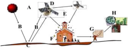
Remote sensing is the science and technology of acquiring information about the Earth's surface without actually being in contact with it. This is done by sensing and recording reflected or emitted energy and processing, analyzing, and applying that information. The principles can be summarized by the figure below
Figure 1. The principles of remote sensing technology
(A)Energy Source or Illumination (E)Transmission, Reception, and Processing (B)Radiation and the Atmosphere (F)Ground station and Data Storage
1088 PROCEEDINGS OF THE INTERNATIONAL CONFERENCE ON UNIVERSITY-COMMUNITY ENGAGEMENT SURABAYA –INDONESIA,2-5AUGUST 2016
With this technology, we are able to enjoy the provision of fine to very fine satellite imageries available from the websites and software applications such as googlemaps, googleearth, bing maps,etc. Availabe airborne and satellite borne images ranges from coarse to very fine resolution depending for what kind application we applying them to. Spatial resolution describes the ability of a sensor to identify the smallest size detail of a pattern on an image. In other words, the distance between distinguishable patterns or objects in an image that can be separated from each other and is often expressed in meters (Lillesand et al. 2004)
ABCD Approach Review
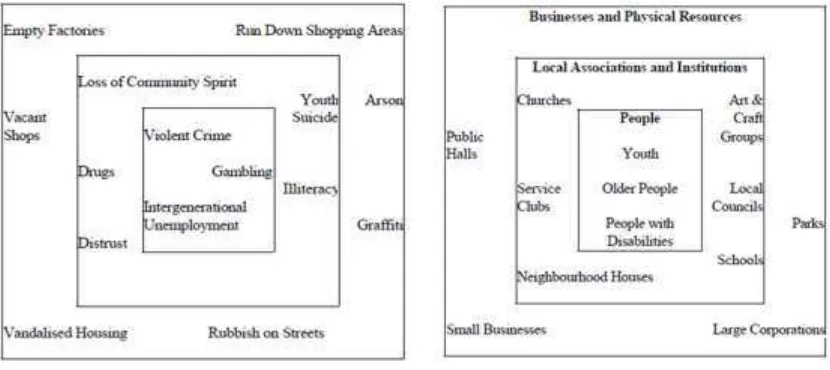
Communities tend to see that they have problem and deficiency if they have economic challenges. They think that they need support from outside because they feel that they do not have jobs, do not have skills, and have less opportunity for young people.
Kretzmann and McKnight argue that all people and all communities are gifted, resourceful and capable even those most marginalised and disadvantaged by social and economic change. Their project is to turn the
“needs map”into an “assets map” (Figures 2&3)
Figure 2. The “needs” map Figure 3. The “assets” map
PROCEEDINGS OF THE INTERNATIONAL CONFERENCE ON UNIVERSITY-COMMUNITY ENGAGEMENT SURABAYA –INDONESIA,2-5AUGUST 2016 1089
In other expert perspective, according to Christoper Derue (2013: 30-31), asset based approaches begin with discovering the stories of success from the past and mapping the assets within a community or organization. Stories
of success are analyzed to find ‘success elements’ or the strategies that have
given life to the community or organization. Assets are mapped in order to be better appreciated (for their productive value or usefulness) and then mobilized.
1. Assets maps
Associations are the basic tool for empowering individuals, building strong communities, creating effective citizens and making democracy work in many countries.
2. Skills inventories
People’s skills and capacities can fall into different categories, including intellectual (head), physical (hand), and emotional (heart). Head
includes, analysis, accounting, organization, business and trading, management, literacy, problem solving, etc. Hand would include cooking, dancing, carpentry, mechanics, sewing, weaving, farming, house construction, etc. Heart would include compassion, helping others, childcare, care of elderly, sense of humor, conflict resolution, willingness to collaborate, etc.
3. Venn diagrams
The Venn diagram represents the associations and their relative size and importance (the closer the component to the center the more important it is).
4. Transects walk
A transect is an effective way of documenting natural and physical assets in more detail. A transect is an imaginary line across an area to capture as much diversity as possible. By walking along that line and documenting observations, an assessment of the range of assets and opportunities can be made.
5. Mapping Physical Resources using Participatory Geographic Information Systems (GIS) Tools.
1090 PROCEEDINGS OF THE INTERNATIONAL CONFERENCE ON UNIVERSITY-COMMUNITY ENGAGEMENT SURABAYA –INDONESIA,2-5AUGUST 2016
through their websites and building networks with other areas also enable one community with other community to share and exchange assets (Mapping Across Borders in Compendium of Tools for ABCD Facilitation, 2012:93)
In this paper, we explore more on this methodology on mapping the above assets. Using GIS and Remote Sensing techniques and combine them with the actual survey in the field, enable us with the local community to identify the community assets used for sustainable development.
Futhermore Christoper Dureue (2013: 139-140) mentioned the full list of assets is:
1. Personal or Human Assets: - Skills, talents, abilities, what you can do well, what you can teach others to do (Skills of the Hands, Head and Heart). 2. Associations or Social Assets: Any organization that has group
membership, Church or Mosque groupings such as Youth and Mothers Union, cultural groups like dance or singing groups, other NGOs and UN groups working in the community or providing training to community members. Associations represent the social capital of the community and
it’s important for the community to understand how rich this is.
3. Institutions: Any government agency or representative body that has connections with the community. These could be committees set up for school based management, for delivering health services, improving electricity, water coverage or for agricultural and livestock services. These are sometimes connected to Social Assets but they really represent a different type of community asset. School committees, local health posts committees and Government sponsored cooperatives could come under this category of assets.
4. Natural assets - land for gardens, fish and shells, water, sunshine, trees and what comes from trees such as wood, fruit and bark; bamboo, reusable building materials, material for dying and weaving, other bush materials, vegetables.
5. Physical assets – tools for gardens, fishing, people who have transport to borrow, people who have houses or buildings to use for meetings, working together and training sessions, pipes, taps, vehicles.
PROCEEDINGS OF THE INTERNATIONAL CONFERENCE ON UNIVERSITY-COMMUNITY ENGAGEMENT SURABAYA –INDONESIA,2-5AUGUST 2016 1091
get more money and use what you get more wisely. Bookkeeping skills for the home and for the group or small business.
7. Spiritual and Cultural assets – you can usually find these by thinking about what is the most important value or ideas in your lives – what are you most passionate about? These include values from being a Muslim, or a Christian, being willing to share, being together to pray and support each other. Or they may be cultural values, such as respecting your in-laws or respecting your feasts and the values of harmony and togetherness. Stories of past heroes, past successful ventures are also included here as they represent elements of success and strategies for moving forward.
It can be concluded that some tools can be used to identify community assets so that the community is able to know their strength, gift, resources of individuals and communities. By knowing their assets they can mobilize themselves, act together and achieve more sustainable community in the future.
One of the components in ABCD program is the actor, whose major role in determining the success of the approach, the local community. In community driven development terms there is what so called a power cube diagram (Gaventa: 2013). In this power cube the smallest unit of community role is performed by an individual, family or household then grows to a bigger scope of community, nation, region that affecting the global community. In other words, the strength of one community is determined by the smallest unit and one community can create a strong community and it depends on the community capacity to provide the needs within the community so it will not be depending on the outer support. The more assets the community have the stronger the community and the longer they can live and interact for each at the community level. To achieve this, the household requires knowledge about what they have and how to use it. This knowledge needs education, experience and local wisdom, (Nur, 2015).
1092 PROCEEDINGS OF THE INTERNATIONAL CONFERENCE ON UNIVERSITY-COMMUNITY ENGAGEMENT SURABAYA –INDONESIA,2-5AUGUST 2016
and a village of Sumillan in the subdistrict of Alla, both located in the Kabupaten of Enrekang. These villages were the target programs of UIN Alauddin KKN students. Other case studies were taken from 2 villages of Sinoa subdistricts of Kabupaten of Bantaeng namely Bontomatene and Bontobulaeng. These 2 villages were the pilot area of KKN Unhas.
Research Objectives
The background objectives of this research is to find solution and to assess how Indonesian community condition in general particularly in the area where the possibility of what so called ABCD approach which stands for Asset Based Community Development are being implemented using the GIS and Remote sensing technology.
Case studies of Mapping Assets using GIS and Remote
sensing
As mentioned in the paper presented by Serliah Nur in the 1st International Conference on University-Community Engagement in 2015, the existing collaborative SILE Project, UIN has established 8 Working Groups which consists of UIN teaching staffs collaborated with representatives of Non Governmental Organisation. This working groups covers several target areas in South Sulawesi. Other than establishing the working group, UIN has also introduced student community service program based on the ABCD approach. The result of this implementation will be discussed in this paper. The case studies will be elaborated based on the KKN location.
Sumillan Village, Subdistrict of Alla, District of Enrekang
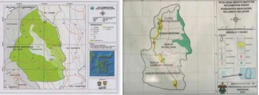
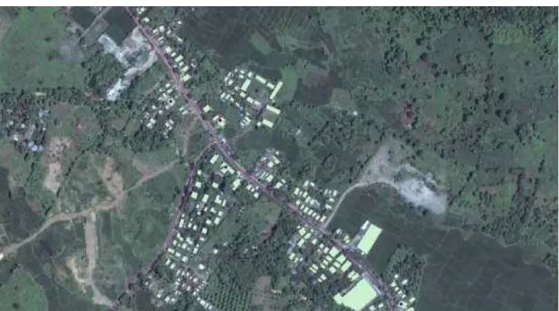
This village was chosen as one pilot study for the ABCD approach among the 2 villages chosen in Kabupaten Enrekang. Below is the satellite image showing the location of both pilot study villages of Sumillan and Lewaja in Kabupaten Enrekanga as shown in Figure 4.
PROCEEDINGS OF THE INTERNATIONAL CONFERENCE ON UNIVERSITY-COMMUNITY ENGAGEMENT SURABAYA –INDONESIA,2-5AUGUST 2016 1093
Figure 4. Staellite image showing Sumillan and Lewaja Village in Enrekang
Below are the description of existing condition of Sumillan Village after being observed by the students.
1. Socio-Economic Conditions
1094 PROCEEDINGS OF THE INTERNATIONAL CONFERENCE ON UNIVERSITY-COMMUNITY ENGAGEMENT SURABAYA –INDONESIA,2-5AUGUST 2016
2. Socio-cultural Conditions
Social life style of Sumillan is agrarian village. The construction sector in the region is impossible to run without any social relationship between the government and its people. The growing community activities in the village Sumillan is religious gathering in every subvillage which is done routinely once a month. This activity runs smoothly and is always crowded as they gather in the mosques of other villages also participated. Youth organizations exists but not active because young people are always directed by their parents to do farming.
3. Religion Social Conditions
Sumillan religious activity in the village has been running smoothly. Religious activities are regularly held in the mosque, namely recitals held each month in each village. This is evident from their religious studies are divided into two recitals regularly every month and as well as activities for children quran learning.
4. Education
The number of villagers who are highly educated quite a lot, this is certainly a good picture of the educational level of Sumillan Village. There are several units or educational institutions ranging from elementary to middle level as their kindergarten Aisyiyah located in Cece, Lintik and Dedekan. There are SD Negeri at Bossok, SDN 32 Cece, in public school Lintik Bt. Kiyyang, as well as MI and MTs Muhammadiyahin Cece.
Based on the observation survey above, below are the programs designed by the students after documenting the local assets (Figure 5).
o Social Economic Conditions; Making Herbal Medicine Planting
(Penanaman Tanaman Toga)
o Socio cultural; Health and Medical Guide Seminar, Procurement of
Garbage Bins
o Religious Social aspects; Islamic Camp, Implementation Practice of Shalat
Jenazah and Children's Religious Festival.
o Educational Aspects; Mobile Library (mobile book) shown in Figure 6,
PROCEEDINGS OF THE INTERNATIONAL CONFERENCE ON UNIVERSITY-COMMUNITY ENGAGEMENT SURABAYA –INDONESIA,2-5AUGUST 2016 1095
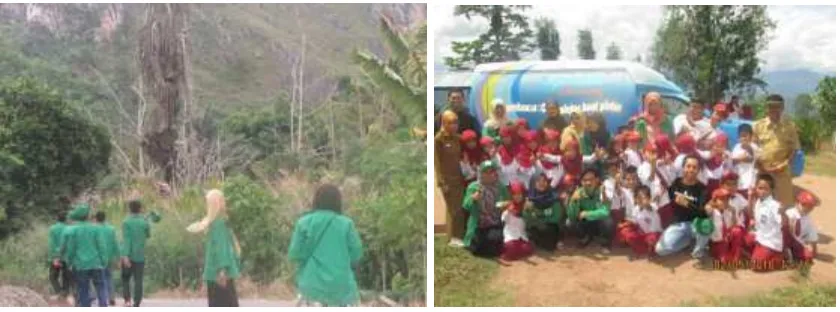
Figure 5. Students survey Figure 6. Mobile Library Program
Lewaja Village, Subdistrict of Enrekang, District of Enrekang
Based on the survey conducted in the first week of the KKN program in Lewaja and Village Program Seminar (Figure 7), the village community mostly have livestock, have abundant natural resources including having a nature that could be a potential revenue for Enrekang district. Below is the description of one major program in Lewaja for Livestock Counseling Program other than education.
Extension livestock are still performed in one environment in the village which is in the neighborhood of Lewaja, Bisang Subvillage. The work program is eagerly awaited by the people of the Lewaja Village for roughly around 80% of village society Lewaja daily activities is a breeder (breeder cows and laying hens). This event was attended by mostly breeders and youth either from the environment of Kukku, Bitu, Langgogo and Bisang. In these activities the students of UIN Alauddin Makassar in cooperation with the Department of Livestock Enrekang. This event was attended by the Head of Department of Animal Husbandry and its members (Figure 8.)
1096 PROCEEDINGS OF THE INTERNATIONAL CONFERENCE ON UNIVERSITY-COMMUNITY ENGAGEMENT SURABAYA –INDONESIA,2-5AUGUST 2016
the term Silage. In the course of these activities many people complain to the animal husbandry department on the issue.
Figure 7. Village Program Seminar Figure 8. Animal Husbandry Counseling
From this activity a variety of diseases from animals either from cows and chickens can be identified. Cattle food can be managed in order to be used during the dry season, because during the dry season feeding animals is very difficult to obtain in this Lewaja environment. People also can learn how to raise livestock services properly.
Bontomatene Village, Subdistrict of Sinoa, District of Bantaeng There are two villages chosen as pilot study from the subdsitrict of Sinoa, Kabupaten Bantaeng. Each one of them are different in views of programs. Bontobulaeng Village (Figure. 9) is a pilot for regular KKN programs while KKN conducted in Bontomanai Village (Figure. 10) involved programs designed by The Ministry of Village, Underdeveloped Regions and Transmigration.
PROCEEDINGS OF THE INTERNATIONAL CONFERENCE ON UNIVERSITY-COMMUNITY ENGAGEMENT SURABAYA –INDONESIA,2-5AUGUST 2016 1097
Based on the asset mapping using GIS and remote sensing images, the KKN students in Bontomanai Village have identified some houses that is not reliable to be dwelled. At the same time they can identify business development centers as well as public facilties such as school, mosque, public health centres. The detail satellite image can also show the local road networks so the student can identify the condition from the field.
Below are the main programs that executed in the field. The Rutilahu and Kube programs. A program called Rutilahu (Rumah Tidak Layak Huni), unreliable dwelling house, is implemented in several villages in several subdistrcits in Kabupaten Bantaeng. One of them is in Bontomatene, as pictured in Figure 11. A house was first identified and then with the local asset and funding support from the village ministry, the house then renovated efficiently so the house become reliably dwelled. Meanwhile, Kube stands for Kelompok Usaha Bersama (Mutual Business Centres). Students identify specific business centres.
Figure 11. Program named Rutilahu (Rumah Tidak Layak Huni) a house unreliable for dwelling, renovated.
Bontobulaeng Village, Subdistrict of Sinoa, District of Bantaeng
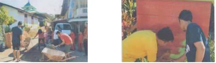
Figure 12. Students KKN activities for helping the mosque construction and village board in Bontobulaeng
1098 PROCEEDINGS OF THE INTERNATIONAL CONFERENCE ON UNIVERSITY-COMMUNITY ENGAGEMENT SURABAYA –INDONESIA,2-5AUGUST 2016
For the purpose of mapping the village asset, fine resolution satellite image such as acquired from Quickbird sensor satellite (Figure. 13) provide detail features to synchronize the mapping on image and field observation. Digitizing the features and building the attribute database for each unit of public facilities like schools, hospital, mosque, etc will create facilities database like AF/FM mapping mentioned in the introduction. In the village of Bontobulaeng, students identified public facilities and designed programs that can be used by the community. Programs can be seen in Figure 12. This is referenced for the same work conducted by Schlosberg in University of Michigan, 2012.
Figure 13. Fine resolution satellite image overlaid with the digitized building for asset mapping
Discussions
Community Asset Mapping as mentioned earlier is the way a community, which in Indonesia the smallest administrative mapping unit is translated as Desa or village, overlook the potential of the village in order to be able to self-sustain. From the KKN case studies above, we have learned that the ABCD approach can actually be implemented in our local community condition especially in South Sulawesi. But on the other hand we should be able to weigh the opportunities and challenges exist in impelementing this approach.
PROCEEDINGS OF THE INTERNATIONAL CONFERENCE ON UNIVERSITY-COMMUNITY ENGAGEMENT SURABAYA –INDONESIA,2-5AUGUST 2016 1099
one map for one nation should be started from the smallest administrative unit in the village. Badan Informasi Geospasial (BIG), Geospatial Information Agency together with LAPAN (Lembaga Penerbangan Antariksa Nasional), Indonesian Aeorspace Agency, will provide spatial data in the form of aerial and satellite borne image for the purpose of mapping the village. This is part of the task of this 2 government institution. The problem is the spirit of the policy cannot directly touch the local village. This is the opportunity that the KKN can help the village to map the area linking it to the community asset mapping.
Initiated since 2015, all KKN in Hasanuddin University started to conduct the village mapping for each KKN area. Provided by spatial data covering the village, the student first assignment is to prepare the basic map of the area and build the database asset belong to the village. After that stage then they can start designing the programs with the community based on what they have identified as assets. Using GIS with available existing data, it is possible to map the full list of the assets criteria. Unfortunately there are some hindrances for this program. First, not all students are familiar with GIS and remote sensing. Secondly, some of the KKN villages area do not have updated or detail coverage of spatial images. Not to mention if the target village area has no village map before. For this area, students are usually requested to search to the local government or technical government agencies who keep government basic maps. Some local government have already completed the Kabupaten Spatial Planning (RTRW) or even has made Kecamatan Detail Spatial Planning (RDTR, Rencana Detail Tata Ruang). For these areas, students will only need to update the existing attribute database. By coordinating with local government and village management, assets mapping can be well performed. Hasanuddin University has one technical support division for the provision of spatial data called PPIDS, Pusat Pengembangan Infrastruktur Data Spasial or in English translated as Center for Spatial Data Infrastructure Development . This division is responsible to assist and coach any area needs for the provision of spatial data.
1100 PROCEEDINGS OF THE INTERNATIONAL CONFERENCE ON UNIVERSITY-COMMUNITY ENGAGEMENT SURABAYA –INDONESIA,2-5AUGUST 2016
development project is conducted in accordance with its intended purpose (Nur 2015).
Initiated with the SILE project KKN in UIN has been trying to implement the ABCD approach with pilot studies in certain villages. A task force providing an ABCD module to be used as guidance for UIN students has successfully printed. The challenge faced by the students in implementing the ABCD approach are still plentiful but step by step action plans are taken slowly to help them fully understand and finally being able to integrate the method of ABCD and Spatial Asset Mapping.
Conclusion
From the discussion above we can conclude that ABCD approach can be implemented with its opportunities and challenges within the local community condition. Understanding the opportunities and challenges faced by students and the local community can make both Hasanuddin University and UIN Alauddin aware of designing the best program for the specific community. The biggest challenge for the implementation of ABCD approach in community service is changing the people’s mindset and preparing the people to have skills that can sustain themselves. This will take time to change. We propose to UIN community service management to prepare local people and all stakeholders and students with ABCD approach and GIS training so they can be more prepared in motivating the target local community.
Acknowledgement
PROCEEDINGS OF THE INTERNATIONAL CONFERENCE ON UNIVERSITY-COMMUNITY ENGAGEMENT SURABAYA –INDONESIA,2-5AUGUST 2016 1101
References
About ABCD http://coady.stfx.ca/themes/abcd/
Compendium of Tools for ABCD Facilitation,. Gordon Institute of Business Sciences (GIBS South Africa) and Coady Institute (St. FX University Canada) (2012)
Cunningham, G., Peters, B., Mathie, A. Mobilizing assets for
community-driven development, participant manual, Coady Institute. (2013).
Dureu, C. . Asset Based and Actor Led Development. Australian Community Development and Civil Society Strengthening Scheme (ACCESS). (2013)
Gaventa Gender and Power Training manual, Coady Institute. (2013)
Huisman, O. R.A. de, Principles of Geographic Information Systems, 2009, ITC, Netherland
Mastuti, S., Masse, Ambo,, Tasruddin, R. University and Community Partnerships in South Sulawesi, Indonesia, Enhancing community
capacity and promoting democratic governance. Gateways:
International Journal of Community Research and Engagement. Vol 7 (2014): 164–173.
Martin,M; Peters, M; and Corbet, J, Participary Asset Mapping in Lake Victoria Basin, Kenya, URISA Journal Volume 24. No.2 (2012): 44-55
Onyx, J; Gateways: International Journal of Community Research and Engagement. (2008): 90-106
Schlossberg, M, Asset Mapping and Community Development Planning with GIS Urban, Technological, and Environmental Planning, University of Michigan, (2012); 1-16.
Serliah Nur, " Working with communities in assets mapping using ABCD approach in Alauddin State Islamic University Makassar" (paper presented at The 1st International Conference on University-Community Engagement. November 25 – 28, 2014).