MAIN ROADS Western Australia 1 of 42 PEIA&E~1
Printed copies are uncontrolled unless marked otherwise
October 2011
PRELIMINARY ENVIRONMENTAL IMPACT ASSESSMENT AND ENVIRONMENTAL MANAGEMENT PLAN (MINOR PROJECTS)
Geraldton Mt Magnet Material Source SLK 153.4
October 2011
CONTENTS
1 PROJECT DESCRIPTION ... 3
2 BACKGROUND ... 3
3 DESCRIPTION OF THE PROJECT ... 3
3.1 PROJECT LOCATION... 3
4 METHODOLOGY ... 7
4.1 PRELIMINARY DESKTOP STUDY ... 7
4.2 COMMONWEALTH REFERRAL ... 8
4.3 SITE INVESTIGATION ... 8
5 EXISTING ENVIRONMENT ... 8
5.1 DESCRIPTION ... 8
5.2 SITE INVESTIGATION ... 8
6 CLEARING OF NATIVE VEGETATION ... 9
6.1 ASSESSMENT AGAINST CLEARING PRINCIPLES ... 9
6.2 ENVIRONMENTALLY SENSITIVE AREA (ESA) ... 9
7 ASSESSMENT OF ASPECTS AND IMPACTS ... 10
8 DECISION TO REFER ... 11
9 STAKEHOLDER CONSULTATION ... 11
10 ENVIRONMENTAL MANAGEMENT PLAN ... 12
10.1 COMMUNICATION PLAN ... 12
11 MONITORING ... 15
12 CONTINGENCY MEASURES ... 15
13 AUDITING ... 15
14 REFERENCES ... ERROR! BOOKMARK NOT DEFINED. APPENDIX A LOW IMPACT ENVIRONMENTAL SCREENING CHECKLIST ... 16
APPENDIX B DEC’S THREATENED FLORA AND FAUNA DATABASE SEARCHES ... 18
APPENDIX C AUSTRALIAN HERITAGE PLACES INVENTORY,HERITAGE COUNCIL OF WESTERN AUSTRALIA AND THE MUNICIPAL HERITAGE INVENTORY DATABASE SEARCHES ... 21
APPENDIX D DEPARTMENT OF INDIGENOUS AFFAIRS DATABASE SEARCH ... 24
APPENDIX E DEC’S SENSITIVE WATER RESOURCES DATABASE SEARCH ... 26
APPENDIX F WAPC’S ACID SULFATE SOILS MAPPING ... 28
APPENDIX G DEPARTMENT OF AGRICULTURE AND FOOD ADVICE ON DECLARED WEEDS .. 30
APPENDIX H DECADVICE ON DIEBACK ... ERROR!BOOKMARK NOT DEFINED. APPENDIX I DEPARTMENT OF THE ENVIRONMENT AND HERITAGE DATABASE SEARCH ... 32
APPENDIX J SITE PHOTOS ... 37
APPENDIX K VEGETATION CLEARING ASSESSMENT REPORT... 42
MAIN ROADS Western Australia 3 of 42 PEIA&E~1
PRELIMINARY ENVIRONMENTAL IMPACT ASSESSMENT AND ENVIRONMENTAL MANAGEMENT PLAN (MINOR PROJECTS) GERALDTON MOUNT MAGNET ROAD MATERIAL SOURCE SLK 153.4
1 PROJECT DESCRIPTION
The proposed works involve the expansion of a current material source located at SLK 153.4 within the Shire of Mullewa. The current material source area was stockpiled in 1995, however more material is required due to the proposed works on the Geraldton Mount Magnet Road.
2 BACKGROUND
The Geraldton Mt Magnet Road is an important heavy vehicle haulage route for triple road trains carrying payloads of 100 tonnes each servicing iron ore deposits in the Murchison area east of Cue and copper and zinc concentrates transported from mines south of Yalgoo.
This heavy road use and regular flooding is causing significant damage to the road structure and as such needs to be repaired in several locations.
As per Main Roads’ Environmental Assessment and Approval process, the Low Impact Environmental Screening Checklist has been completed for the proposal, refer to Appendix A. As the proposed works involves requires clearing outside of the
maintenance zone, the preparation of a project specific Preliminary Environmental Impact Assessment (PEIA) and Environmental Management Plan (EMP) are required. This report fulfils this requirement.
3 DESCRIPTION OF THE PROJECT
• The proposed works involve:
• The re-stockpiling of current stockpiles, to remove regrowth currently on the stockpiles;
• Clearing of vegetation for the expansion of the material source area;
• Stockpiling of material for proposed works;
• Herbicide control of vegetation growing on stockpile areas; and
• Rehabilitation of disturbed areas (existing and current).
3.1 Project Location
The location and boundaries of the study area are shown on Figures 1-3 and include the following features:
MAIN ROADS Western Australia 5 of 42 PEIA&E~1
MAIN ROADS Western Australia 7 of 42 PEIA&E~1
4 METHODOLOGY
4.1 Preliminary Desktop Study
A preliminary assessment of the project area and its potential constraints was undertaken by reviewing a number of government agency managed databases (and consulting where necessary).
4.1.1 Wetlands
The locations of wetlands within the project area was determined using the Commonwealth
Department of the Environmental and Heritage (DEH) mapping tool, Department of Environment and Conservation (DEC) Geographic Data Atlas mapping tool.
4.1.2 Threatened Flora, Fauna and Communities, Conservation Reserves and ESAs
DEC’s database was searched for known populations of threatened flora, fauna and Threatened Ecological Communities (TECs) and conservation reserves, refer to Appendix B. A Biological Survey was also conducted by GHD (D10#50868)
4.1.3 Air Quality
The need for a local air quality assessment was determined using the criteria outlined in the MRWA environmental guideline, Air Quality.
4.1.4 Heritage
Non-indigenous heritage was examined utilising the Australian Heritage Places Inventory
(http://www.heritage.gov.au), Heritage Council of Western Australia (http://register.heritage.wa.gov.au/) and the Shire/Town/City of <Name>’s Municipal Heritage Inventory, refer to Appendix C.
4.1.5 Aboriginal Heritage
A Search of the Department of Indigenous Affairs’ (DIA’s)
(http://www.dia.wa.gov.au/Heritage/SitesSurveysSearch.aspx) database was undertaken to determine whether the project area contains any sites of Aboriginal heritage, refer to Appendix D.
4.1.6 Sensitive Water Resources
The Department of Water’s website was utilised to determine whether the project area supported, or was adjacent to, any significant lakes, rivers or wetlands or proclaimed areas, refer to Appendix E.
4.1.7 Contaminated Sites
The DEC Contaminated Sites website was utilised to determine if the site has been listed as contaminated.
4.1.8 Acid Sulfate Soils
The CSRIO’s Australian Soil Resource Information System website was used to determine the level of ASS risk.
4.1.9 Weeds
A Biological Survey was conducted by GHD which listed the weeds present at the site.
4.1.10 Dieback
Project receives <400 mm of rain so determined not to be an issue.
4.2 Commonwealth Referral
The decision whether to refer the project to the Commonwealth’s DEH was based upon whether the project would impact upon matters of national significance, e.g. World Heritage properties, protected wetlands and migratory species, Commonwealth marine areas, threatened species or communities or nuclear actions (refer to the Commonwealth webpage
www.deh.gov.au/epbc/assessmentsapprovals/index.html for further information and the search tool page at http://www.deh.gov.au/erin/ert/epbc/imap/map.html), refer to Appendix I.
4.3 Site Investigation
A site visit was carried out by GHD on 31/8/2009 to examine the general features of the area. The broad vegetation types in the vicinity of the project area were identified. Other issues that were
considered included topography, the impacts on creek lines, property access and the potential for noise and vibration impacts (dilapidation).
Site photos were taken and are included in Appendix J.
5 EXISTING ENVIRONMENT 5.1 Description
The GHD Biological Survey Report describes the following:
• The vegetation types classified during the field survey were extrapolated and found matched with the following vegetation associations:
– Vegetation Association 364: Shrublands; bowgada scrub with scattered Eucalypts and cypress pine; and
– Vegetation Association 419: Shrublands; bowgada, jam and Melaleuca uncinata thicket;
• These vegetation types are considered Least Concern, with at least 96% of the preEuropean extents considered to be remaining in the Yalgoo Biogeographic Regionalisation for Australia (IBRA) region (Shepherd, 2005).
5.2 Site Investigation
Site Investigation Description/Comment
Total area (ha) of native vegetation to be cleared
10
Total area (ha) of other vegetation, including regrowth, landscape areas, to be cleared
0
Weeds present A total of 9 weed species were identified during the field survey. No weed species,
recorded in the Project Area are classified as Weeds Of National Significance
(WONS) or listed as a Declared Plant under the Agriculture and Related Resources
Act (1976);
Drainage areas or wetlands present Nil
Adjacent land uses Pastoral
MAIN ROADS Western Australia 9 of 42 PEIA&E~1
6 CLEARING OF NATIVE VEGETATION
Native vegetation describes all indigenous aquatic and terrestrial vegetation (living or dead). The term does not include vegetation that was intentionally sown, planted or propagated unless it was required under a statutory condition.
Apart from activities that are exempt under the clearing regulations, such as clearing vegetation that is less than 10 years old for maintenance, typically all Main Roads clearing will be undertaken using its Statewide Project Purpose Permit.
6.1 Assessment against Clearing Principles
In assessing whether the project is likely to have a significant impact on the environment, the project has been assessed against the DEC’s 10 principles of clearing, refer to Appendix K.
The project will maybe at variance with the DEC’s 10 clearing principles. Clearing of native vegetation in the Project Area is considered likely to be at variance with principle ‘b’.
6.2 Environmentally Sensitive Area (ESA)
Clearing within an Environmentally Sensitive Area (ESA)
Yes/
No
Comments Does the area to be cleared occur within
an ESA where the vegetation is in good or better condition?
N
7 ASSESSMENT OF ASPECTS AND IMPACTS
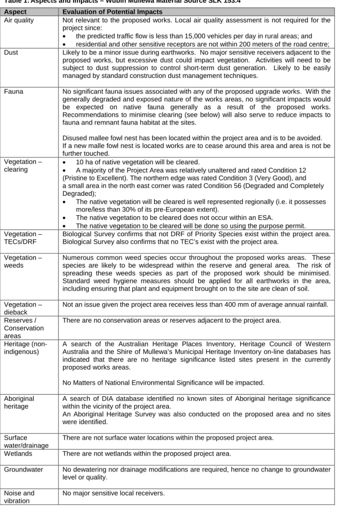
Table 1: Aspects and Impacts – Wubin Mullewa Material Source SLK 153.4 Aspect Evaluation of Potential Impacts
Air quality Not relevant to the proposed works. Local air quality assessment is not required for the project since:
• the predicted traffic flow is less than 15,000 vehicles per day in rural areas; and
• residential and other sensitive receptors are not within 200 meters of the road centre;
Dust Likely to be a minor issue during earthworks. No major sensitive receivers adjacent to the proposed works, but excessive dust could impact vegetation. Activities will need to be subject to dust suppression to control short-term dust generation. Likely to be easily managed by standard construction dust management techniques.
Fauna No significant fauna issues associated with any of the proposed upgrade works. With the generally degraded and exposed nature of the works areas, no significant impacts would be expected on native fauna generally as a result of the proposed works.
Recommendations to minimise clearing (see below) will also serve to reduce impacts to fauna and remnant fauna habitat at the sites.
Disused mallee fowl nest has been located within the project area and is to be avoided.
If a new malle fowl nest is located works are to cease around this area and area is not be further touched.
Vegetation – clearing
• 10 ha of native vegetation will be cleared.
• A majority of the Project Area was relatively unaltered and rated Condition 12 (Pristine to Excellent). The northern edge was rated Condition 3 (Very Good), and a small area in the north east corner was rated Condition 56 (Degraded and Completely Degraded);
• The native vegetation will be cleared is well represented regionally (i.e. it possesses more/less than 30% of its pre-European extent).
• The native vegetation to be cleared does not occur within an ESA.
• The native vegetation to be cleared will be done so using the purpose permit.
Vegetation – TECs/DRF
Biological Survey confirms that not DRF of Priority Species exist within the project area.
Biological Survey also confirms that no TEC’s exist with the project area.
Vegetation – weeds
Numerous common weed species occur throughout the proposed works areas. These species are likely to be widespread within the reserve and general area. The risk of spreading these weeds species as part of the proposed work should be minimised.
Standard weed hygiene measures should be applied for all earthworks in the area, including ensuring that plant and equipment brought on to the site are clean of soil.
Vegetation – dieback
Not an issue given the project area receives less than 400 mm of average annual rainfall.
Reserves / Conservation areas
There are no conservation areas or reserves adjacent to the project area.
Heritage (non- indigenous)
A search of the Australian Heritage Places Inventory, Heritage Council of Western Australia and the Shire of Mullewa’s Municipal Heritage Inventory on-line databases has indicated that there are no heritage significance listed sites present in the currently proposed works areas.
No Matters of National Environmental Significance will be impacted.
Aboriginal heritage
A search of DIA database identified no known sites of Aboriginal heritage significance within the vicinity of the project area.
An Aboriginal Heritage Survey was also conducted on the proposed area and no sites were identified.
Surface water/drainage
There are not surface water locations within the proposed project area.
Wetlands There are not wetlands within the proposed project area.
Groundwater No dewatering nor drainage modifications are required, hence no change to groundwater level or quality.
Noise and vibration
No major sensitive local receivers.
MAIN ROADS Western Australia 11 of 42 PEIA&E~1
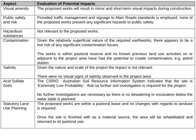
Table 1: Aspects and Impacts – Wubin Mullewa Material Source SLK 153.4 Aspect Evaluation of Potential Impacts
Visual amenity The proposed works will result in minor and short-term visual impacts during construction.
Public safety and risk
Provided traffic management and signage to Main Roads standards is employed, none of the proposed works present any significant hazards to public safety.
Hazardous substances
Not relevant to the proposed works.
Contamination Given the relatively superficial nature of the required earthworks, there appears to be a low risk of any significant contamination issues.
The works is within pastoral reserve and no known previous land use activities on or adjacent to the project area have had the potential to create contamination, e.g. petrol station.
Salinity Given the nature and scale of the project the impact is not relevant.
There were no visual signs of salinity observed in the project area.
Acid Sulfate Soils
The CSRIO Australian Soil Resource Information System indicates that the site is
‘Extremely Low Probability’. that no further soil investigation is required for the project.
No further investigations are necessary as there is no dewatering or excavation below the water table is planned.
Statutory Land Use Planning
The proposed works are within a pastoral lease and no changes with regards to landuse is required.
Once the site is finished with as a material source, the area will be rehabilitated and returned to its pastoral use.
8 DECISION TO REFER
Given the scale of the project, the low significance of its impacts to the surrounding environment and the environmental management measures proposed, the project does not require referral to the WA Environmental Protection Authority or the Commonwealth Department of the Environment and Heritage.
9 STAKEHOLDER CONSULTATION
Name Agency Date Comments
Josh Foster GHD September
2009
Refer to Biological Survey Report D10#50868
10 ENVIRONMENTAL MANAGEMENT PLAN
This section of the report (the EMP) has been developed for the project area following the completion of the above sections. The main aim of this EMP is to provide a management plan to assist in
minimising the environmental impacts of the activities associated with the proposed works and identify who is responsible for the implementation of the management strategies.
This EMP will only address the actions already listed as well as any site-specific issues that were identified during the PEIA. The project specific management measures identified within this EMP are in addition to the standard specifications used for Category 2 projects. The environmental management measures/conditions in Main Road’s Specifications 203, 204, 301, 302 and 304 are still to be followed where applicable.
The areas that require special management will be addressed in terms of:
• the timing of the various management actions;
• the topic (e.g. vegetation);
• the objectives for each area;
• the actions that are necessary to minimise the impact;
• the responsible party for implementing the action; and
• whether the action arose from external advice or is a Main Roads requirement.
10.1 Communication Plan
Environmental issues specific to the project will be communicated as follows:
Method Frequency Participants Reference Record Project Site
Induction Prior to Work All personnel and subcontractors
EMP and Contractor Environmental Policy
Induction Meeting
Toolbox Meetings Weekly Project Personnel Contractor Safety Plan
Minutes of Meeting
10.1.1 External Communication and Complaints
A complaints register shall be maintained by the contractor. All complaints received shall be forwarded to the Main Roads’ Project Manager for action. Serious complaints shall be investigated within 24 hours of the complaint being received.
MAIN ROADS Western Australia 13 of 42 PEIA&E~1
ENVIRONMENTAL MANAGEMENT PLAN
Timing Topic Objective Action Responsible Party Advice
All phases of Construction
Vegetation Clearing - Record-keeping
All projects should maintain the required records relating to clearing native vegetation under the purpose permit.
Clearing:
• a copy of the PEIA & EMP (Minor projects) for small projects;
• a map showing the location where the clearing occurred, recorded in an ESRI Shapefile;
• the size of the area cleared (in hectares); and
• the dates on which the clearing was done.
Project Manager DEC
Revegetation and rehabilitation of areas:
• a copy of each Revegetation Plan;
• a map showing the location of any area revegetated and rehabilitated recorded in an ESRI Shapefile;
• a description of the revegetation and rehabilitation activities undertaken; and
• the size of the area revegetated and rehabilitated (in hectares).
Project Manager DEC
Each offset implemented:
• a copy of each offset proposal;
• a map showing the location of any offset implemented recorded in an ESRI Shapefile;
• a description of the offset implemented; and
• the size of the area of the offset (in hectares).
Project Manager DEC
Pre-Construction Vegetation - Clearing
Ensure that the overall objectives of the alignment and construction works are compatible with maintaining and, where possible, enhancing the biological integrity of the surrounding environment and minimising
vegetation loss and degradation; and Ensure the retention of as many habitat trees, shrubs and vegetated corridors for fauna as possible, particularly where associated with riparian zones.
Selection of designs/locations that minimise adverse impacts on the biological environment.
Project Manager Main Roads Construction works to be undertaken in summer to reduce the
potential for soil erosion and drainage line siltation due to vegetation removal and heavy rains.
Project Manager Main Roads
Control/spray weeds species within the project area prior to construction to limit the amount of propagative material that may be spread during disturbance.
Contractor Main Roads
Any stockpiled vegetation from clearing works shall not be burnt. This vegetation shall be used during any rehabilitation works and either chipped or replaced according to the EMP.
Contractor Main Roads
Construction Noise, Vibration and Dust
Ensure that the construction of the proposal does not become a nuisance to the public.
Access to private property and appropriate traffic management measures should be planned and implemented prior to the construction of works.
Contractor Main Roads
Works associated with the construction of the development should not prevent public access along the adjacent reserve.
Public access should be maintained along the reserve at all times.
Contractor Main Roads
Any complaints regarding dust will be attended to as soon as possible.
Contractor/Project Manager
Main Roads
ENVIRONMENTAL MANAGEMENT PLAN
Timing Topic Objective Action Responsible Party Advice
Where it is found that trucks leaving the site are carrying excessive material onto sealed surfaces, these areas will be swept to reduce dust generation and maintain traffic safety.
Contractor Main Roads
Watering, the use of hydromulch or other forms of mulching to protect loose surfaces shall be used as mitigation measures.
Contractor Main Roads
Construction Pollution and Litter
Ensure that the construction of the proposal is managed to a standard that minimises any adverse impacts on the environment.
The designated servicing area will be bunded to contain any spills or leaks and shall not be located in an area adjacent to any drainage areas or watercourses or will drain into a temporary sump.
Contractor Main Roads
Emergency cleanup procedures shall be implemented in the case of any spillage. These will include control of spilled material and removal of contaminated soil to an approved site.
The contractor shall ensure appropriate equipment is available at all times and shall notify the Superintendent’s
Representative of a spill.
Contractor Main Roads
All waste oil will be collected for recycling and any empty fuel/oil containers, used filters and waste hydraulic parts to be collected and stored in an allocated area then removed to an approved site.
Contractor Main Roads
Dumping or temporary storage of bitumen, asphalt, concrete or aggregate should only occur at designated depots or controlled hardstands.
Contractor Main Roads
The project areas, including hardstand areas, will be kept in a tidy manner at all times.
Contractor Main Roads
Construction Fire Ensure that the fire risk associated with the construction of the proposal is minimised.
No fires shall be lit within the project area. Contractor Main Roads Machinery will be fitted with approved spark arresting mufflers. Contractor Main Roads A water tanker will be on site at all times. Contractor Main Roads Construction Site
Management
Ensure that the site is managed to ensure that construction of the proposal will have minimal impact upon the surrounding environment.
Site office and materials storage areas will be located on previously disturbed/ designated area.
Contractor Main Roads
Post-Construction Rehabilitation Leave the project area free from debris; and
Rehabilitate the project area so that the revegetated area provides a net increase in area of native vegetation at the site.
Replace the cleared trees with locally occurring natives. Project Manager Main Roads All waste materials from the development are to be completely
removed from the site upon completion of the development.
Final clean-up shall be to the satisfaction of the Project Manager and the Site Superintendent.
Contractor Main Roads
MAIN ROADS Western Australia 15 of 42 PEIA&E~1
11 MONITORING
After project completion, revegetated areas will be inspected every six months for the first two years to ensure weed spread or establishment has not occurred and to measure the effectiveness of
revegetation works.
A Revegetation Plan with a Monitoring Schedule will be developed.
12 CONTINGENCY MEASURES
Given the scale and nature of the project, no contingency measures are identified as the inherent environmental risks are small.
13 AUDITING
Given the scale and nature of the project, there is no requirement for auditing the implementation of the EMP as the environmental risks are small.
Appendix A
Low Impact Environmental Screening Checklist
MAIN ROADS Western Australia 17 of 42 PEIA&E~1
Appendix B
DEC’s Threatened Flora and Fauna Database Searches
MAIN ROADS Western Australia 19 of 42 PEIA&E~1
http://maps.dec.wa.gov.au/idelve/nv/index.jsp (03/12/2009)
http://spatial.agric.wa.gov.au/slip/framesetup.asp (03/12/2009)
Source: http://maps.dec.wa.gov.au/idelve/nv/index.jsp (21/10/11)
MAIN ROADS Western Australia 21 of 42 PEIA&E~1
Appendix C
Australian Heritage Places Inventory, Heritage Council of Western Australia and the Municipal
Heritage Inventory Database Searches
Source: http://www.environment.gov.au/heritage/places/wa/index.html (21/10/11)
MAIN ROADS Western Australia 23 of 42 PEIA&E~1
Source: http://register.heritage.wa.gov.au/search_results.html (21/10/11)
Appendix D
Department of Indigenous Affairs Database Search
MAIN ROADS Western Australia 25 of 42 PEIA&E~1
Source: http://www.dia.wa.gov.au/AHIS/default.aspx (21/10/11)
Appendix E
DEC’s Sensitive Water Resources Database Search
MAIN ROADS Western Australia 27 of 42 PEIA&E~1
Source: http://www.water.wa.gov.au/idelve/dowdataext/index.jsp (21/10/11)
Appendix F
Acid Sulfate Soils Mapping
MAIN ROADS Western Australia 29 of 42 PEIA&E~1
Source: http://www.asris.csiro.au/mapping/viewer.htm (21/10/11)
Appendix G
Contaminated Sites Database
MAIN ROADS Western Australia 31 of 42 PEIA&E~1
Source: https://secure.dec.wa.gov.au/idelve/css/ (21/10/11)
Appendix H
Department of the Environment and Heritage Database Search
MAIN ROADS Western Australia 33 of 42 PEIA&E~1
MAIN ROADS Western Australia 35 of 42 PEIA&E~1
MAIN ROADS Western Australia 37 of 42 PEIA&E~1
Appendix I
Site Photos
Photos taken 22/05/2009
MAIN ROADS Western Australia 39 of 42 PEIA&E~1
MAIN ROADS Western Australia 41 of 42 PEIA&E~1
Appendix J
Vegetation Clearing Assessment Report
Refer to D10#50868 (pages 75-82)