Herring Road, Macquarie Park Finalisation Report
May 2015
© Crown copyright 2015 Published May 2015
NSW Department of Planning www.planning.nsw.gov.au Disclaimer:
While every reasonable effort has been made to ensure that this document is correct at the time of publication, the State of New South Wales, its agents and employees, disclaim any and all liability to any person in respect of anything or the consequences of anything done or omitted to be done in reliance upon the whole or any part of this document.
Executive Summary
The Finalisation Report provides an overview of the Herring Road Priority Precinct and the planning amendments proposed by State Environmental Planning Policy (Major Development) Amendment (Ryde) 2014. The Finalisation Report summarises the public consultation undertaken and responds to the issues raised in public submissions.
The Priority Precinct program (previously called Urban Activation Precincts) was established by the NSW Government in 2012 as a way of providing homes and jobs for Sydney’s growing population.
Potential precincts with good access to infrastructure, public transport and services and where development is economically feasible were identified for further investigations.
The Herring Road Priority Precinct was nominated by City of Ryde in July 2012. The Precinct includes Macquarie University and Macquarie Shopping Centre and is in close proximity to the employment opportunities offered by Macquarie Park. The Precinct is well serviced by public transport including bus services, the Epping to Chatswood Rail Line, and in the future the North West Rail Link.
Upgrades to the M2 have also been completed recently, including new ramps at Christie Street, which improve access to the precinct.
The precinct investigations focussed on the walking catchment around Macquarie University Railway Station and along Herring Road, which are predominantly zoned B4 Mixed Use under Ryde Local Environmental Plan 2012. The proposal includes amendments to the Ryde LEP to increase the height and density controls, particularly around the station and major road intersection approaches to the precinct.
The precinct will deliver up to 5,800 dwellings by 2031, transforming the area into a vibrant centre that makes the most of the available transport infrastructure and the precinct’s proximity to jobs, retail and education opportunities within the Macquarie Park corridor.
Additional infrastructure needed to support additional growth in the precinct will be funded through local contributions to Council and works in kind. Those contributions will be indexed to CPI and will match growth over time. A revised infrastructure schedule is included at Appendix A.
City of Ryde will also have access to up to $5 million through the Precinct Support Scheme (PSS) established by the NSW Government. This money can be used to accelerate the delivery of selected public domain improvements or local infrastructure upgrades needed for the precinct.
Council nominated the embellishment of the open space parkland along Shrimptons Creek and improvements to pedestrian connections along Shrimptons Creek, Wilga Park and Elouera Reserve as a potential project for the $5 million PSS funding. The Department supports Council’s nomination for PSS funding as it will assist Council with the provision of public domain works.
The Government’s proposal for the Precinct was developed in consultation with the community, land owners and Council. The proposal was publicly exhibited from 26 June to 10 August 2014. In response, eighty (80) submissions were received. A petition was received with 175 names. An online survey was completed by 120 people.
Herring Road Finalisation Report 3
The key issues raised in the submissions were:
• Need for additional social infrastructure and open space to support for population growth
• Impact of new development on traffic congestion and car parking in Macquarie Park
• Uncertainty around the future of the Ivanhoe Housing Estate
• Adequacy of public transport infrastructure to accommodate additional people in the area
• Impact of proposed height and density controls on the character of the area
• Economic feasibility of the proposed height and density controls
• Suitability of the built form and urban design outcomes achieved by the structure plan
• Deliverability and cost of the proposed road network
• Expansion of the precinct to rezone sites outside the study area
• General concerns about the planning process and consultation with community.
In response to the public consultation, the following amendments are recommended:
• Amend the pedestrian and cycleway network plan to reflect Council’s Bicycle Strategy and to not include a new separated cycleway along Herring Road at this time.
• Amend the open space network plan to identify potential locations for four new local parks and improved pedestrian access through Macquarie University and to Lane Cove National Park.
• Amend the local road network plan to remove some of the proposed road connections and modify the location of the proposed link road between Peach Tree Road and Ivanhoe Place.
• Amend the proposed zoning controls by retaining the current RE1 Recreation zone boundary along Shrimptons Creek.
• Amend the proposed height and floor space ratio controls to focus more development close to the Macquarie University railway station where the proximity to public transport supports higher densities.
• Include a “satisfactory arrangements” provision that requires Macquarie Shopping Centre and Macquarie University to make provision towards any future upgrades to the bus interchange before residential development can be approved on those sites.
• Include a clause that allows land previously dedicated to Council for roads or other public uses to be counted as site area for the calculation of floor space ratio.
The revised structure plan drawings are included at Appendix B.
Herring Road Finalisation Report 4
Amendments to Ryde Local Environmental Plan 2014
To deliver the precinct, a State Environmental Planning Policy is proposed to amend the existing planning controls in Ryde Local Environmental Plan 2014 (LEP 2014). A summary of the proposed amendments is provided below in Table 1.
The proposed SEPP will also amend State Environmental Planning Policy (Major Development) 2005 by repealing the provisions relating to Macquarie University (Part 21 of Schedule 3) as new controls for the University campus which will be added to LEP 2014 as part of the Urban Activation Precinct.
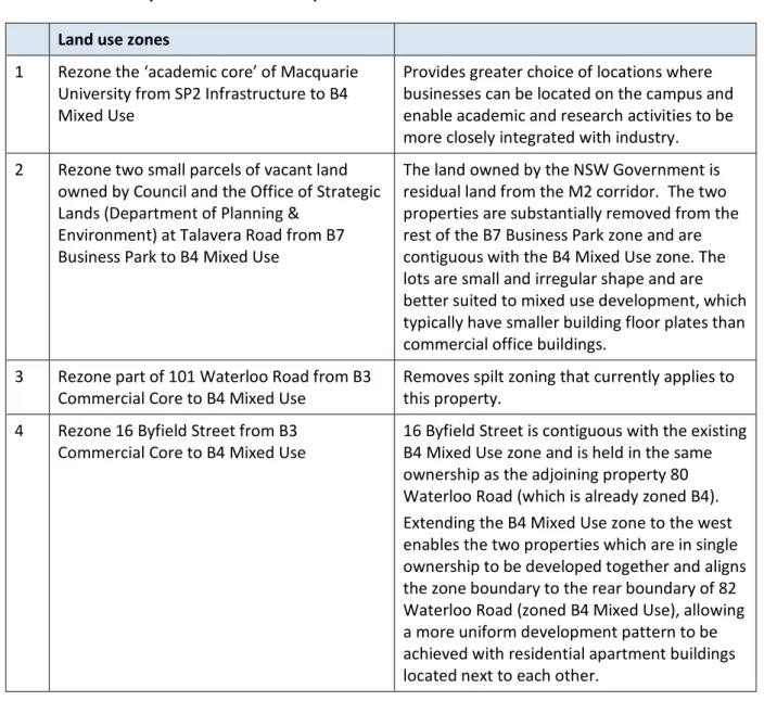
Table 1: Summary of amendments to Ryde Local Environmental Plan 2014 Land use zones
1 Rezone the ‘academic core’ of Macquarie University from SP2 Infrastructure to B4 Mixed Use
Provides greater choice of locations where businesses can be located on the campus and enable academic and research activities to be more closely integrated with industry.
2 Rezone two small parcels of vacant land owned by Council and the Office of Strategic Lands (Department of Planning &
Environment) at Talavera Road from B7 Business Park to B4 Mixed Use
The land owned by the NSW Government is residual land from the M2 corridor. The two properties are substantially removed from the rest of the B7 Business Park zone and are contiguous with the B4 Mixed Use zone. The lots are small and irregular shape and are better suited to mixed use development, which typically have smaller building floor plates than commercial office buildings.
3 Rezone part of 101 Waterloo Road from B3
Commercial Core to B4 Mixed Use Removes spilt zoning that currently applies to this property.
4 Rezone 16 Byfield Street from B3
Commercial Core to B4 Mixed Use 16 Byfield Street is contiguous with the existing B4 Mixed Use zone and is held in the same ownership as the adjoining property 80 Waterloo Road (which is already zoned B4).
Extending the B4 Mixed Use zone to the west enables the two properties which are in single ownership to be developed together and aligns the zone boundary to the rear boundary of 82 Waterloo Road (zoned B4 Mixed Use), allowing a more uniform development pattern to be achieved with residential apartment buildings located next to each other.
A map showing the location of the sites proposed to be rezoned is included on the following page in Figure 1.
Herring Road Finalisation Report 5
Figure 1: Land use zoning amendments Building heights
1 Railway station - 120m height limit applying to land at Macquarie Shopping Centre and Macquarie University next to the railway station
The highest buildings within the precinct, which are up to 37 storeys, are located closest to the railway station. This creates building landmarks to signify the location of the station and provides more development and activity close to where public transport is available.
2 Talavera Road ‘gateway’ – 90m height limit applying to land at 112 Talavera Road, Macquarie University and Macquarie Shopping Centre
Allows buildings up to 28 storeys at the northern entrance to the precinct from the M2, which are within 200m to 400m of the railway station.
3 Epping Road ‘gateway’ – 75m height limit applying to the land fronting Herring Road between Epping Road and Ivanhoe Place.
Allows buildings up to 23 storeys at the southern entrance to the precinct from Epping Road, which are similar in scale to the
approved tower building at the Stamford Plaza.
4 Waterloo Road – 65m height limit applying to land fronting Waterloo Road and the strata apartments adjacent Elouera Reserve
Allows buildings up to 20 storeys consistent with the scale of future commercial building along Waterloo Road envisaged under draft LEP Amendment No. 1.
20 storey buildings are permitted on sites adjoining Elouera Reserve which provides good
Herring Road Finalisation Report 6
amenity and are closest to the railway station 5 Ivanhoe Estate – 65m height limit applying
to land fronting Epping Road and 45m height limit adjacent to existing strata apartments.
Allow buildings up to 20 storeys along Epping Road positioned behind the existing trees and vegetation which provides some screening and where the building shadows fall mainly onto Epping Road.
Building heights up to 14 storeys are proposed on the northern half of the estate to manage overshadowing of other buildings and open space.
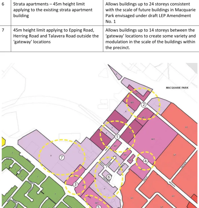
6 Strata apartments – 45m height limit applying to the existing strata apartment building
Allows buildings up to 24 storeys consistent with the scale of future buildings in Macquarie Park envisaged under draft LEP Amendment No. 1
7 45m height limit applying to Epping Road, Herring Road and Talavera Road outside the
‘gateway’ locations
Allows buildings up to 14 storeys between the
‘gateway’ locations to create some variety and modulation in the scale of the buildings within the precinct.
Figure 2: Building height control amendments
Herring Road Finalisation Report 7
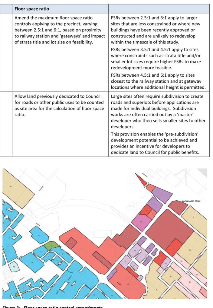
Floor space ratio
Amend the maximum floor space ratio controls applying to the precinct, varying between 2.5:1 and 6:1, based on proximity to railway station and ‘gateways’ and impact of strata title and lot size on feasibility.
FSRs between 2.5:1 and 3:1 apply to larger sites that are less constrained or where new buildings have been recently approved or constructed and are unlikely to redevelop within the timescale of this study.
FSRs between 3.5:1 and 4.5:1 apply to sites where constraints such as strata title and/or smaller lot sizes require higher FSRs to make redevelopment more feasible.
FSRs between 4.5:1 and 6:1 apply to sites closest to the railway station and at gateway locations where additional height is permitted.
Allow land previously dedicated to Council for roads or other public uses to be counted as site area for the calculation of floor space ratio.
Large sites often require subdivision to create roads and superlots before applications are made for individual buildings. Subdivision works are often carried out by a ‘master’
developer who then sells smaller sites to other developers.
This provision enables the ‘pre-subdivision’
development potential to be achieved and provides an incentive for developers to dedicate land to Council for public benefits.
Figure 3: Floor space ratio control amendments
Herring Road Finalisation Report 8
Minimum lot size
Introduce a minimum lot size control of 1,800m2 for the existing residential strata buildings on Herring Road, Lachlan Avenue, Peach Tree Road and Cottonwood Crescent
Requires smaller lots to be amalgamated to create sites that are large enough to
accommodate the building floor plates and the building setback and separation distances required for apartment buildings over 25m under the current SEPP 65 Residential Flat Design Code.
Macquarie University car parking rate Introduce a maximum car parking rate of 1 space per 80m2 of gross floor area for new commercial or industrial buildings on Macquarie University.
The extent of B4 zoned land on the university is being increased to provide flexibility for the university to attract commercial and business uses onto the campus mixed with academic and teaching uses.
The maximum car parking rates that apply under Ryde LEP 2014 to commercial and industrial uses in Macquarie Park (based on proximity to public transport) should also apply to these uses on the university campus.
Similar car parking restrictions already apply to Macquarie University under Schedule 3 of the Major Development SEPP, which is being repealed by this instrument and therefore are incorporated into the Ryde LEP instead.
Bus interchange upgrades
Include a provision that requires Macquarie Shopping Centre and Macquarie University to make satisfactory arrangements for the provision of dedicated State public
infrastructure before residential
development can be approved on the site.
The land owner of the shopping centre and Macquarie University lodged an unsolicited proposal to Government to upgrade the existing bus interchange.
The Government’s assessment of the unsolicited proposal is continuing and a final decision has not been made.
The ‘satisfactory arrangements’ clause allows the planning for the precinct to be finalised immediately whilst allowing the negotiations between the Government, land owner and Macquarie University for the bus interchange to continue.
Herring Road Finalisation Report 9
Community consultation
The Department of Planning and Environment engaged in an extensive program of consultation throughout the design and development of the proposal. The consultation process is described in Chapter 4 and Appendix E of the Planning Report and in further detail below.
Early consultation included forums with land owners and community to develop ideas and design principles for the precinct, presentations and Q&A sessions at public meetings organised by City of Ryde, presentations to Ivanhoe residents and meetings with Council staff and Government agencies.
Public exhibition
The proposal was publicly exhibited for 6 weeks from 26 June to 10 August 2014. The proposal was advertised in local and Sydney metropolitan newspapers and could be viewed at the Council’s and Department’s offices, at local libraries and online at the Department’s website.
Community information sessions were held on 23 and 26 July 2014. An information session was also held on 25 July 2014 at the Ivanhoe Estate specifically for public housing tenants and was attended by staff from the Department of Planning and Environment and the Department of Family and Community Services.
Postcards with information about the proposal and the public exhibition were distributed to approximately 6,400 residents in the local area and almost 1,900 notification letters were sent to land owners. Submissions could be made on-line via the Department’s website or by mail. An on- line survey could also be completed during the exhibition period.
Eighty (80) written submissions were received, of which 54 were from residents or land owners, which is considered a relatively low response rate given the extent of the notification area. An online survey was completed by 120 people. A petition with 175 names was also received.
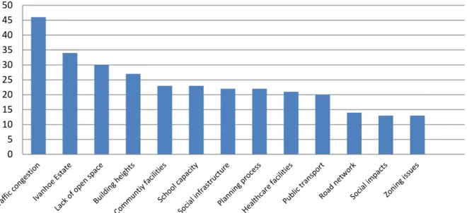
Over half the written submissions expressed concerns about traffic congestion in the area. Concerns about the future of the Ivanhoe public housing estate were raised in over a third of the submissions.
The key issues raised in the submissions were:
• Impact of new development on traffic congestion and car parking in Macquarie Park
• Adequacy of public transport infrastructure to accommodate additional people in the area
• Suitability of the built form and urban design outcomes achieved by the structure plan
• Impact of proposed height and density controls on the character of the area
• Economic feasibility of the proposed height and density controls
• Need for additional social infrastructure and open space to support for population growth
• Uncertainty around the future of the Ivanhoe Housing Estate
• Deliverability and cost of the proposed road network
• Expansion of the precinct to rezone sites outside the study area
• General concerns about the planning process and consultation with community.
The Department has considered all submissions and responses to the key issues are provided in the next section of the report.
Herring Road Finalisation Report 10
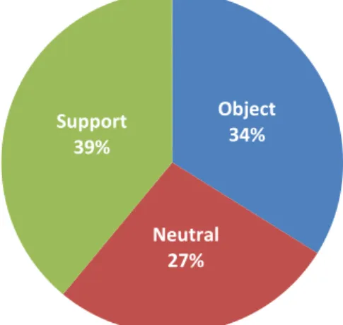
Figure 4: Written submissions view of the proposal (n=80)
Figure 5: Online survey respondents view of the proposal (n=118)
Figure 6: Key issues in written submissions (n=308)
Object 56%
Neutral 14%
Support 30%
Object 34%
Neutral 27%
Support 39%
0 5 10 15 20 25 30 35 40 45 50
Herring Road Finalisation Report 11
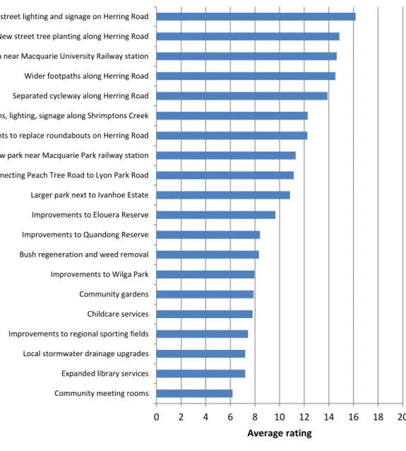
During the public exhibition period, the community was consulted on possible projects to receive the Precinct Support Scheme funding and the respondents to the online survey were asked to rank a list of 20 infrastructure projects in order of preference.
The survey did not reveal a clear preference for a single project to receive the Precinct Support Scheme funds. Instead, at least five projects received strong support from survey respondents:
• Improved street lighting and signage
• New street tree planting along Herring Road
• New civic plaza near the entrance to the Macquarie University Railway station
• Wider footpaths along Herring Road
• Separated cycleway along Herring Road
Figure 7: Community preferences for Precinct Support Scheme funding (n=119)
0 2 4 6 8 10 12 14 16 18 20
Community meeting rooms Expanded library services Local stormwater drainage upgrades Improvements to regional sporting fields Childcare services Community gardens Improvements to Wilga Park Bush regeneration and weed removal Improvements to Quandong Reserve Improvements to Elouera Reserve Larger park next to Ivanhoe Estate Bridge connecting Peach Tree Road to Lyon Park Road New park near Macquarie Park railway station Traffic lights to replace roundabouts on Herring Road Improved paths, lighting, signage along Shrimptons Creek Separated cycleway along Herring Road Wider footpaths along Herring Road New civic plaza near Macquarie University Railway station New street tree planting along Herring Road Improved street lighting and signage on Herring Road
Average rating
Herring Road Finalisation Report 12
Response to issues
Traffic congestion
Concerns were raised in the submissions about the existing traffic congestion in Macquarie Park and the impact of new development on the capacity of the road network. Council was particularly concerned about existing traffic congestion at the intersection of Epping Road and Herring Road and suggested that the intersection be grade separated prior to any further development occurring.
Council also proposed that the intersection of Epping Road and Lyon Park Road be signalised.
Response:
The intersection of Herring Road and Epping Road, which is one of the main road entries to the Macquarie Park business park, currently experiences capacity constraints, particularly during the AM peak period, resulting in high congestion levels. The existing traffic congestion issues are largely due to people travelling to jobs located within the Macquarie Park corridor.
The Herring Road Priority Precinct proposes amendments to the planning controls to enable more housing to be provided within the walking catchment of Macquarie University railway station. By providing new housing in areas that are close to public transport and employment areas reduces the demand for private car use for travelling to work because of the other transport options available.
The ABS census data for the 2001 to 2011 period shows that private vehicle use by residents within the precinct for their journey to work has fallen by 14% from 47% to 33% of trips. By comparison, private vehicle use by people travelling to Macquarie Park for work remains relatively high at 68% of trips (in 2011), although this has also fallen from 79% of trips in 1996.
The changes in peoples travel behaviour and the shift away from private car use for journey to work, corresponds strongly with the opening of the Epping to Chatswood Rail Link in 2009, which improved public transport access to Macquarie Park and provided a significant catalyst for new growth and development. Since the opening of the Macquarie University station, there has been considerable growth in the daily patronage, increasing from 10,980 entries/exits per day from the station in 2009 to 17,020 in 2011.
The North West Rail Link is scheduled to open in 2019/20 and will provide a heavy rail connection from the Hills to Macquarie Park and the Herring Road precinct. The completion of the North West Rail Link will allow the frequency and capacity of train services to Macquarie Park to be increased. In particular, the North West Rail Link could reduce travel times by as much as 30% and increase frequency up to 12 trains per hour during peak periods.
In addition to the significant investment being made in public transport, upgrades to the M2 Motorway have also been completed in August 2013 which provide a new westbound off ramp at Herring Road, a new eastbound on ramp at Christie Road and additional lanes west of Lane Cove Road. These upgrades will reduce congestion on the M2 Motorway, increase the speed limit to 100km/h from Delhi Road to Pennant Hills Road and improve road access to Macquarie Park.
Herring Road Finalisation Report 13
Negotiations are also underway with Macquarie University and the Roads and Maritime Service to secure contributions towards regional road infrastructure improvements as result of development permitted under the University’s Part 3A Concept Plan.
It is considered that the precinct can support additional residential development without major upgrades to the regional road network because of the public transport infrastructure currently available and planned in the future, as well as the changes in travel behaviour whereby people are using private vehicles less for travel during the peak periods.
In response to Council’s proposal to signalise the intersection of Lyon Park Road and Epping Road, the introduction of signals would allow the full range of turn movements to be made (currently only
‘left-in’, ‘left-out’ turns are allowed) and could assist in dispersing some of the traffic within the business park and improving access into the precinct. However, the introduction of new traffic signals on Epping Road could also have an adverse impact on the overall performance of the road network and as such Council’s proposal should be considered closely by the Roads and Maritime Service.
Public transport
Concerns were raised in submissions about the adequacy of public transport to accommodate additional population growth. Whilst there was general support for upgrading the bus interchange at Macquarie Shopping Centre, Council was concerned about the capacity of the interchange and its ability to handle extra buses during the temporary closure of the rail line during construction of the North West Rail Line.
Response:
In addition to expansion of Sydney’s heavy rail network, including the Epping to Chatswood Rail Link and the North West Rail Link project, the NSW Government is also investigating a Parramatta light rail and the Macquarie Park via Carlingford route is one of four options shortlisted for further investigation. $400 million has been committed to analyse these route options in further detail.
Should Macquarie Park be chosen as the preferred route, it would provide another public transport option for commuters and could potentially provide further increases to public transport capacity.
Macquarie Park is also well serviced by buses with 27 different bus routes currently accessing the precinct. It is anticipated that the existing bus interchange at Macquarie Shopping Centre will require upgrading in the short to medium term (5-10 years) to provide additional capacity for buses and improve pedestrian safety. The NSW Government is currently investigating the interchange upgrade requirements further and is assessing an unsolicited proposal from Macquarie University and the owners of Macquarie Shopping Centre to deliver a new transport interchange and town centre.
In response to submissions about the bus interchange, amendments are proposed to the Ryde Local Environmental Plan that will require Macquarie Shopping Centre and Macquarie University to make satisfactory arrangements for the provision of upgrades to the bus interchange before significant development can be approved along the Herring Road frontages.
Herring Road Finalisation Report 14
The ‘satisfactory arrangements’ could be in the form a voluntary planning agreement between the owners of Macquarie Shopping Centre, Macquarie University and the NSW Government to make contributions towards the upgrade of the bus interchange and could be in the form of works in kind and/or dedication of land.
Car parking
Support was received from AMP Capital (Macquarie Shopping Centre) and Stamford Property Services (110-114 Herring Road) for the exhibited car parking rate of 1 space per unit. City of Ryde suggests that more stringent parking rates should be adopted and notes that a 2014-15 parking study is being prepared for Macquarie Park.
Response:
One of the key strategies to address traffic congestion in employment areas such as Macquarie Park is to provide new housing in locations that can easily access jobs via high quality public transport.
Limiting the amount of car parking provided in employment areas (as Ryde LEP currently does) is also an effective measure to encourage people to make more trips using public transport, walking or cycling instead of by car, provided those options are available.
The exhibited proposal suggested that a maximum car parking rate of one space per dwelling would be appropriate given the availability of public transport available and proximity to jobs in Macquarie Park balanced against the likely market demand for car parking within new residential buildings.
However, it is acknowledged that car parking rates are ultimately a local issue and should be set by Council and implemented through amendments to their Development Control Plan.
It also proposed that the car parking limits under Ryde LEP 2014 for commercial and industrial development in Macquarie Park should be extended to apply to those parts of Macquarie University zoned B4 Mixed Use and would apply in addition to the car parking conditions under the existing Concept Plan approval.
Cycleways
Council raised concerns that the cycleway network proposed in the structure plan does not integrate with the Council’s Bicycle Strategy and in particular does not support a cycleway on Herring Road.
Response:
The exhibited structure plan proposed a new cycleway along Herring Road between Waterloo Road and Epping Road that could be extended further to Kent Street to connect to the regional cycle network. This would enable cyclists to access popular destinations such as Macquarie University, the shopping centre and the railway via a direct route along Herring Road although some reduction in the width of the landscape verge in the middle of the road would be needed.
There is an existing shared cycle pedestrian path along Shrimptons Creek already links the precinct and railway station to the wider regional cycle network and being an off-road path through open space is more likely to be used by a wider range of cyclists, including young children and people travelling to work.
Herring Road Finalisation Report 15
Given the lack of support from Council for a new cycleway on Herring Road and that existing cycle routes already provide connections to the precinct, it is not recommended to include the Herring Road cycleway in the final structure plan. Nonetheless, Council could still pursue the Herring Road cycleway in the future should they decide to do so.
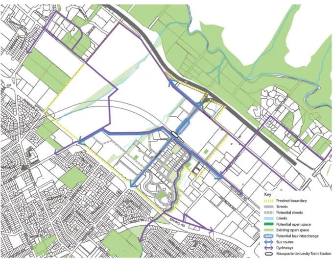
Figure 8: Revised cycle network Building heights and densities
Submissions were received both in favour and against the proposed building heights and densities.
The submissions objecting to the proposed building heights and densities were concerned about potential impacts from new development and changes to the character of the area. The submissions in support considered the controls were appropriate given the precinct’s access to transport and were needed to make redevelopment feasible and to renew older housing stock. An assessment of the development feasibility and potential take-up was undertaken by the Department using tools such as the Urban Feasibility Model.
Council does not support the concept of gateway sites having higher FSRs and heights than the neighbouring sites and considers this to be inequitable. Council does not support FSRs and heights greater than those exhibited by Council under draft LEP Amendment No. 1 (a 45m height limit across the precinct with a 65m limit along Waterloo Road and FSRs between 1.5:1 and 3:1, with the lowest at the edges along Epping and Talavera Roads and the highest densities along Waterloo Road).
Herring Road Finalisation Report 16
Submissions were also received from land owners within the precinct seeking modifications and increases to the exhibited height and floor space ratio controls, which are considered below.
Response:
Redistribution of floor space
The submissions from Macquarie University and Goodman, the owners of 112 Talavera Road, sought modifications to the floor space ratio controls to transfer some of the potential floor space to parts of the site where redevelopment is more likely.
In the case of Macquarie University, the exhibited controls proposed a floor space ratio control of 4.5:1 for the area between the railway station and Talavera Road. This area includes vacant land next to the railway station and two existing commercial buildings. The floor space ratio for the two commercial buildings is proposed to be lowered to reflect the existing floor space of those buildings (2.5:1 and 3.5:1) and the FSR applying to the vacant land is increased by a corresponding amount to 6:1.
These modifications result in the same floor space being achievable over the site area but with more of that floor space will be located closer to the railway station, which is consistent with the principles of the structure plan. The 120m height limit is retained for the area immediately next to the station, so while the buildings may be denser or have larger floor plates, they will not be taller and not result in additional shadowing impacts on the properties and parks on the southern side of Herring Road.
In the case of 112 Talavera Road, the exhibited controls proposed a floor space control of 3.5:1 for the site. A commercial building (Fujitsu) has been recently completed and is being subdivided from the rest of the site. It is proposed to reduce the FSR on the Fujitsu lot to 2.9:1 to closely match the floor space existing building and to transfer the potential floor space that is unlikely to have been achieved on the Fujitsu lot by increasing the FSR on the remainder of the site to 4.5:1.
Height at ‘gateway’ locations
The exhibited structure plan and proposal located the tallest buildings closest to the railway station and then the next tallest buildings are at the major road intersections that access the precinct, providing ‘landmark’ or ‘gateway’ buildings. The submissions from Baptist Care, Stamford and Goodman sought increases the height controls at ‘gateway’ locations to the precinct.
At the corner of Epping and Balaclava Roads, a height limit of 45m is considered appropriate for the Baptist Care site. This will achieve a more sympathetic transition in the scale of buildings moving away from Epping Road towards the University campus. A 45m high building at the corner of Epping and Balaclava Road would still be taller than surrounding buildings but the transition in scale would be more gradual and sympathetic to the height of the Shalom Centre seniors housing and buildings along University Avenue and Macquarie Drive, such as Cochlear and the Hearing Hub.
At the corner of Epping and Herring Roads, the exhibited height limit of 75m on the front portion of the Stamford site is consistent with the existing approval for that site. It is recommended that 75m height limit continue along Herring Road to the intersection of Ivanhoe Place as exhibited, allowing a
Herring Road Finalisation Report 17
cluster of taller buildings to be located at the entry to the precinct with lower scale buildings up to 45m located in the middle of the street block.
At the corner of Herring and Talavera Roads, the exhibited height limit of 90m is considered
appropriate given this is the closest of the three gateway locations to the railway station. Goodman proposed that the 90m height limit on 112 Talavera Road be extended along Talavera Road to the boundary of the Fujitsu lot and along Herring Road towards the M2 Motorway. It is considered that the height zone only be expanded towards the M2, such that the taller buildings are concentrated at the corner of the site and there is a more gradual transition in height next to the Fujitsu building and a lower scale building opposite the park at Macquarie University.
Provision of public benefits
Submissions were received from Goodman (82 and 101 Waterloo Road) seeking to increase the floor space ratio controls on those sites primarily on the basis that significant public benefits such as public open space could be delivered on the sites and the requirements of the SEPP 65 Residential Flat Design Code could still be achieved.
A similar submissions was received from Holdmark in relation to 66-82 Talavera Road, proposing it be rezoned B4 Mixed Use (it is outside the precinct boundary) and greater height and floor space ratio controls be permitted on the basis that a playing field sized open space could be provided.
The final structure plan identifies the two Waterloo Road properties as potential locations for new parks and open spaces, which could be connected to the existing open space network via the pedestrian and cycle paths along Shrimptons Creek. However, provision of public benefits like local parks in exchange for increased development yield is a matter for Council and the land owner to consider through the Planning Agreement process as part of future development applications.
In the case of the Holdmark proposal, it is considered that the area surrounding the precinct already provides sufficient amounts of open space and playing fields. However, should Council wish to provide additional playing fields within the precinct, it could consider a planning proposal to rezone the Holdmark property and as part of that process, prepare a planning agreement with the land owner to dedicate land for open space.
Macquarie Shopping Centre
The proposed extension to the 120m height zone at Macquarie Shopping Centre provides some flexibility so the central tower building can be located slightly further to the north which will address some of the practical construction issues with building above an existing and operational shopping centre. Shifting this height zone slightly to the north will not result in any additional overshadowing impacts from the tower buildings, which in any case, largely fall on the shopping centre itself.
Draft LEP Amendment No. 1
Draft Ryde LEP Amendment No. 1 proposes a 65m height limit (20 storeys) fronting Waterloo Road to create a ‘development spine’ running through the centre of Macquarie Park with a 45m height limit (14 storeys) applying to the rest of the area. The height and FSR controls proposed in draft LEP
Herring Road Finalisation Report 18
Amendment No. 1 can only be accessed where developers enter into a voluntary planning agreement with the Council to provided additional infrastructure or funding for infrastructure.
The draft LEP exhibited by Council included land within the Herring Road Urban Activation Precinct.
However, the final LEP submitted to the Department for plan making no longer includes land within the Herring Road precinct and its future planning controls will be determined through the Urban Activation Precinct process.
Notwithstanding the above, the key differences between the UAP proposal and the exhibited draft LEP Amendment No. 1 are taller buildings along Herring Road particularly close to the railway station where the access to public transport supports higher densities, residential towers above Macquarie Shopping Centre and an economically feasible development outcome for the Ivanhoe Estate.
The UAP controls retain a 65m height limit along Waterloo Road consistent with the height limit proposed by Council under draft LEP Amendment No. 1. This will ensure the height and scale of buildings along Waterloo Road within the precinct are consistent with the desired future character and streetscape envisaged by Council under draft LEP Amendment No. 1.
Expansion of the precinct
A submission was received from Holdmark requesting 66-82 Talavera Road be included in the precinct, rezoned to B4 Mixed with a height limit of 120m and a floor space ratio of 3.5:1. The zoning and controls proposed by Holdmark significantly increase the development potential of the site and they have offered to dedicate 1.5 hectares of open space to Council, large enough for a playing field.
Response:
The Holdmark property is located outside the precinct boundary and was not included in the public exhibition of the proposed amendments to Council’s LEP. Whilst there may be merit in diversifying the mix of land uses within Macquarie Park by allowing some residential uses that would activate and increase the vibrancy of the corridor outside of business hours, ideally these issues would be considered as part of a broader strategic review into the future role of Macquarie Park rather than on an ad hoc basis with planning proposals for individual sites.
School infrastructure
Concerns were raised in submissions that additional schools are needed to accommodate population growth in the area.
Response:
The Department of Planning has forecast using the Urban Feasibility Model that the precinct could deliver almost 5,800 dwellings by 2031. It is predicted that development will be staged over that time frame, with 475 dwellings produced by 2016, 1622 dwellings in 2016-2021, 1,906 dwellings in 2021-2026 and finally 1,792 dwellings in 2026-2031.
Herring Road Finalisation Report 19
Department of Education and Communities (DEC) have been consulted on the proposal and have completed an education needs analysis for the area. DEC have advised that the existing schools in the area will have sufficient capacity in the short to mid-term.
Within the next 10 years, additional classrooms may need to be provided at existing schools and DEC may need to provide a new primary school in the area. A number of redevelopment projects to increase existing school capacities have already been included within DEC’s 10 year Total Asset Management Plan. DEC has commenced preliminary investigations into the redevelopment of a former school site.
The timing for any upgrades to schools will depend on the rate of development as well as the demographic profile of the community, which will determine the number of school aged children living in the precinct. These factors will be monitored by the Department of Education and Communities and will inform their forward planning for school infrastructure.
Hospitals and health facilities
Concerns were raised in submissions that additional infrastructure such as hospitals are needed to accommodate population growth in the area.
Response:
In planning for social infrastructure such as public hospitals and health facilities, the NSW Government takes into consideration range of matters such as projected growth from new
development, changes over time to the demographic profile of the area and the capacity of existing and/or planned infrastructure to meet the needs of the community.
Community facilities
Concerns were raised in submissions that additional community facilities need to be provided to accommodate population growth in the area.
Response:
New local community facilities, such as libraries and community rooms, needed to meet the demand generated by the additional population in the precinct would be funded through local contributions collected by the Council.
It is considered that social infrastructure and community facilities can be provided for the precinct through the local contributions framework. As the precinct develops over time and the socio- demographic characteristics of the precinct emerge, Council can tailor specific infrastructure to meet the needs of the growing community.
Open space and parks
A number of submissions believed more open space and parks should be provided to meet the needs of the future population of the precinct. Submissions were also received on behalf of a number of land owners identifying possible locations within their property where open space or sporting fields could be incorporated as part of a future redevelopment. A submission was also
Herring Road Finalisation Report 20
received on behalf of the Morling College (120-128 Herring Road) objecting to the proposed open space shown on their property.
Response:
The Herring Road proposal identified significant amounts of open space and sporting fields in the area surrounding the precinct, including Lane Cove National Park, Marsfield Park, Waterloo Park, Macquarie University, Christie Park and ELS Hall Park. The exhibited proposal also identified opportunities to improve existing local parks and creek corridors within the precinct.
It is recommended that a network of small local parks dispersed throughout the precinct and connected to other open space areas by the creek corridors would best serve the open space needs of the existing and future residents. These local parks could be provided by individual developers as works in kind in lieu of Section 94 contributions as the precinct develops over time.
The final structure plan includes the potential open space locations suggested by the land owners, with the exception of 66-82 Talavera Road which is outside the precinct boundary. The pedestrian link to the Lane Cove National Park proposed by Transurban is supported subject to Transurban obtaining any approvals that may be required from National Parks and Wildlife Services.
It is also recommended that the potential open space shown on Morling College be retained in the final structure plan, consistent with Council’s Development Control Plan. This ensures a local park can be provided in a central location on the northern side of Herring Road. The location identified in Figure 9 below is indicative and will be determined as part of the development application process.
Figure 9: Revised open space network
Herring Road Finalisation Report 21
New road connections
Submissions were received from the following land owners concerning the proposed road network in the precinct structure plan:
• Macquarie University proposed modifications to the campus road network to enhance University Avenue as a key pedestrian link
• Baptist Community Services and Morling College did not support the proposed road link between Balaclava and Herring Roads and claim it unreasonably burdens their property and the alignment conflicts with existing uses and buildings (such as Willandra Village)
• UrbanGrowth NSW suggested the proposed linkage to Peach Tree Road be relocated onto land zoned RE1 Recreation to avoid acquisition of private land.
• Council supported the proposed local road network in the structure plan but recommended that the extension of Peach Tree Road to Lyon Park Road and the proposed link from Cottonwood Crescent to Lachlan Avenue be two way roads (instead of one way).
Response:
In response to submissions, the final structure plan identifies local road infrastructure to improve connectivity and accessibility within the precinct, including:
• Retention of the proposed street connecting Balaclava Road to Herring Road
• Relocation of the link road to Peach Tree Road onto land zoned RE1 Recreation
• Potential extension of Peach Tree Road to Lyon Park Road as a two way road
• Potential replacement of the roundabout on Herring Road with traffic signals
• Enhance University Avenue as a key pedestrian link.
Figure 10: Revised local road network
Herring Road Finalisation Report 22
The proposed local road upgrades infrastructure could be delivered by Council with funding from Section 94 contributions or by individual developers as works in kind in lieu of contributions or as requirements of conditions of approval. The location of the proposed roads in the structure plan is indicative only. The final alignment and configuration of these roads should be resolved between the Council and land owners through the development application process or as part of future amendments to the Development Control Plan.
Ivanhoe Estate
Concerns were raised in submissions from both residents and advocacy groups about the future of the Ivanhoe public housing estate.
Response:
New height and floor space ratio controls are proposed for the Herring Road Urban Activation Precinct, including the Ivanhoe estate, having regard to the future character of the area and amenity impact considerations. However, the Government has not made any decision about the Ivanhoe housing estate.
Affordable housing
Concerns were raised in submissions about affordable housing with some suggesting the amount of affordable rental housing could be increased through a value capture mechanism implemented as conditions on development approvals. Council proposed an affordable housing target of 10% for the precinct, to be funded or delivered by future development.
Response:
Affordable housing is currently addressed in NSW through a number of ways. A Plan for Growing Sydney recognises that the Government needs to deliver more opportunities for affordable housing.
Action 2.3.3 in the Plan states that the Government will:
o “develop a comprehensive approach to this issue that involves all stakeholders – the Government, local councils and the private and community sectors;
o provide affordable housing in Government-led urban renewal projects and on Government- owned sites to meet the shortfall in affordable housing; and
o require local councils to include affordable housing in their local housing strategies, to respond to local demand.”
The Government will require each council to prepare a local housing strategy that identifies how the council will deliver a range of building forms and types, aligned with market demand, minimum household projections and development capacity in their local area. The government will also require local councils to include affordable housing in their local housing strategies, to respond to local demand.
The Government will provide affordable housing in Government-led urban renewal projects and on Government-owned sites to meet the shortfall in affordable housing.
Herring Road Finalisation Report 23
In this regard, Land and Housing Corporation is developing an affordable housing strategy for the Government’s public housing assets which include the Ivanhoe Estate within the precinct.
State Environmental Planning Policy (Affordable Rental Housing) 2009 provides incentives for some residential development when they include affordable housing, as well as encouraging new
affordable housing that is compatible with its surroundings and in locations that are well served by public transport.
Under Section 93F of Environmental Planning and Assessment Act, planning agreements can be made between a planning authority and a developer, whereby the developer may agree to provide or fund affordable housing usually in exchange for some development incentives, such as additional density.
Sydney Turpentine Ironbark Forest
The Office or Environment and Heritage advised that Sydney Turpentine Ironbark Forest is located within the precinct, primarily on the Ivanhoe Estate, and its biodiversity values should be considered and appropriate zoning and planning controls implemented, where necessary.
Response:
The Sydney Turpentine Ironbark Forest located on the Ivanhoe Estate is an important environmental factor within the precinct. The proposed height and density controls were tested using aerial photography and a 3D model to ensure the footprint of the proposed buildings and road network could be accommodated without significantly impacting on the Sydney Turpentine Ironbark Forest along the Epping and Herring Road frontages of the site. Should any impacts be likely, a detailed flora and fauna assessment would be required for any future development applications.
Riparian corridors
The Department of Primary Industries and the Office of Environment and Heritage recommended that the riparian corridors be clearly defined with appropriate planning controls be prepared and the corridors be rezoned from RE1 Public Recreation to E2 Environmental Conservation.
Response:
It is agreed that appropriate planning controls can support the management and protection of riparian corridors and help improve their overall condition and environmental quality.
Shrimptons Creek, which runs along the eastern side of the precinct, is zoned E2 Environmental Conservation and RE1 Public Recreation under the Ryde LEP 2014. The creek corridor is public land under the management of City of Ryde. The existing LEP zoning under the LEP as well as Council’s Development Control Plan provides appropriate planning controls and management regime for riparian corridors.
Mars Creek and Kikkiya Creek flow through the precinct and are generally within the Macquarie University. The Macquarie University Concept Plan’s conditions of approval and statement of commitment requires the University to implement further measures with regard to management of riparian areas.
Herring Road Finalisation Report 24
The setback requirements from the riparian zones within the University campus will be determined as part of the assessment of future applications in consultation with Office of Environment and Heritage. The University also proposed to prepare urban design guidelines to protect and enhance the Mars Creek riparian corridor with new native planting.
Environment and heritage
Submissions from Council and Government agencies identified a range of environmental and heritage issues that should be considered, such as water quality, air pollution, noise emissions, waste management and impacts on Aboriginal objects and cultural values.
Response:
Part 4.5 of the City of Ryde Development Control Plan contains detailed controls for the site and building design requirements impacts within Macquarie Park. Specifically, the DCP controls address environmental issues such as wind impacts, noise and vibration, bushfire management, floodplain management, stormwater drainage, waste management, soil management and contamination.
These matters can be addressed through the development application process and appropriate conditions of consent
Heritage items within the precinct are identified in Ryde Local Environmental Plan 2014 and include building ruins located at Macquarie University. Development that is likely to have an impact on a heritage item or an Aboriginal object or that involves disturbing or excavating an archaeological site or Aboriginal place of heritage significance requires consent. A heritage impact assessment and management plan is typically required and Council would consult relevant State agencies before granting approval.
Environmentally sustainable development
Council’s submission suggests that environmental sustainable development principles need greater consideration and requirements for Green Star, NatHERS and NABERS ratings should be included for the precinct.
Response:
State Environmental Planning Policy (Building Sustainability Index: BASIX) 2004 addresses energy and water efficiency and sustainable building design. It applies to all residential dwellings and is part of the development application process. BASIX uses an online assessment tool and checks elements of a proposed design against sustainability targets.
Council’s Development Control Plan addresses energy efficiency and sustainability and includes environmental performance controls for both commercial and residential development in Macquarie Park and these provisions would apply to development within the precinct.
Stormwater drainage and flooding
Council’s submission suggests that controls should be prepared requiring adherence to Water Sensitive Urban Design principles. Council’s submission also identifies that parts of the precinct are affected by flooding which may affect the overall development yield.
Herring Road Finalisation Report 25
Response:
The existing controls in Council’s Development Control Plan adequately address stormwater drainage and flooding requirements and any potential impacts can be assessed through the development application process and by appropriate conditions of consent.
In addition, the approved Macquarie University Concept Plan include an infrastructure master plan (for the University) which addresses building setbacks for flood and riparian zones, on-site storm water detention requirements and water sensitive urban design principles.
Utilities and services
Council’s submission queried whether the existing utilities infrastructure is capable of supporting additional development.
Response:
Sydney Water and Ausgrid were consulted during the public exhibition period. Sydney Water confirmed that the trunk system has capacity to service the development of the precinct and some local upsizing and extensions of wastewater mains may be required. Ausgrid did not make a submission and therefore it is considered that the existing electricity infrastructure is sufficient.
The provision utilities and services, and any augmenting requirements, can be addressed through the development application process and by appropriate conditions of consent.
Growth projections
Council’s submission claims the precinct could yield a total of 12,464 dwellings and a population of 26,175 people. The exhibited study for the precinct forecast that 5,400 dwellings could be delivered by 2031. The Department has undertaken further analysis using the Urban Feasibility Model and forecasts that the precinct could deliver 5,796 dwellings by 2031 compared to Ryde LEP 2014 which would deliver only 509 dwellings.
Response:
The Council’s forecast assumes every site is developed to its theoretical maximum capacity under the LEP controls and does not take into account factors such as economic feasibility, market demand and development constraints such as site amalgamation requirements, design guidelines and
environmental factors.
The Department has undertaken a more detailed analysis using a feasibility model and estimates the feasible development potential of the precinct at approximately 9,100 dwellings with 5,796
dwellings forecast to be completed by 2031. Compared to Ryde LEP 2014, the proposed controls creates potential for an additional 6,500 dwellings within the precinct, of which, the majority are feasible to develop. By 2031, it is forecast that the proposed controls for the precinct would result in almost 5,300 more dwellings than the current Ryde LEP controls.
Herring Road Finalisation Report 26
Infrastructure funding
Council believes that significant development uplifts should be tied to the delivery of infrastructure and that a value capture mechanism is needed to ensure that sufficient funding can be obtained for this purpose. Council is concerned that the decision to remove the precinct from the draft LEP Amendment No. 1 will leave Council with a funding shortfall of $7.1 million in relation to new parks and roads.
Response:
Local infrastructure needed to support growth in the precinct can be funded through Section 94 contributions collected by Council or can delivered by developers either as works in kind (in lieu of monetary contributions) or to meet conditions of approval.
Alternatively, Section 93F of the Environmental Planning & Assessment allows planning authorities and developers to enter agreements to provide public benefits such as local infrastructure in exchange for further development incentives.
Based on Council’s current Section 94 Plan (and assuming a unit mix of 15% studio, 30% one bed units, 45% two bed units, and 10% three bed units), it is estimated development within the precinct (5,796 dwellings by 2031) could generate over $90 million in developer contributions in today’s values and are indexed to CPI. The local contributions would be levied through development and collected by Council over time as sites develop and generate a significant amount of funding to provide local infrastructure to support the growth in the precinct.
Table 3: Potential Section 94 contributions from the precinct
Item Amount (indexed to October 2014)
Community and cultural facilities $14,504,809 Open space and recreation facilities $58.186,180 Civic and urban improvements $7,484,821 Road and traffic management facilities $8,038,345 Transport and accessibility facilities $0
Cyclists $1,034,780
Stormwater management facilities $916,046
Plan administration $279,060
Total $90,444,041
The structure plan identifies potential road links that are desirable to improve connectivity and permeability within the precinct as well as possible locations for new local parks and provides a framework to assist Council with prioritising how the local contributions will be spent in the precinct over the next 20 years.
Herring Road Finalisation Report 27
Precinct support scheme
On 20 May 2015, City of Ryde nominated the embellishment of the open space parkland along Shrimptons Creek and improvements to pedestrian connections along Shrimptons Creek, Wilga Park and Elouera Reserve as a potential project for the $5 million (PSS) funding. Council has already prepared an open space master plan for the creek corridor.
Response:
Up to $5 million in funding will be provided to Council through the Precinct Support Scheme (PSS) to fund local infrastructure in the precinct.
The Department supports Council’s nomination for PSS funding as it will assist Council with the provision of public domain works. City of Ryde Council’s nomination is also consistent with the Herring Road Precinct’s open space framework.
The Department’s precinct plan seeks to improve pedestrian connectivity throughout the precinct and uses the existing open space network to support this initiative. The upgrading of existing open spaces such as Shrimptons Creek, Wilga Park and Elouera Reserve will encourage and support new residential development and provide places for passive and active recreation.
Development Control Plan
Council’s submission raises concerns about the setbacks, building floor plate sizes and street widths, proposed in the structure plan.
Response:
The proposal recommended certain development controls be included in Council’s Development Control Plan to achieve the urban design and built form outcomes envisioned for the precinct. After discussing with Council staff, it is agreed that the City of Ryde will be responsible for preparing any amendments to the Development Control Plan to implement the Herring Road Urban Activation Precinct structure plan.
Planning process
Concerns were raised in submissions that planning powers have not been handed back to local communities and that adequate consultation was not undertaken with Council.
Response:
The Herring Road Urban Activation Precinct was nominated by the City of Ryde in July 2012. The nomination of the precinct was endorsed by the NSW Government in November 2012 and the precinct planning work commenced shortly after.
The community and Council have been consulted extensively through planning process. Workshops were held with the community during the development of the proposal. The Department presented preliminary proposals at public meetings organised and chaired by the City of Ryde Council. The
Herring Road Finalisation Report 28
final proposal was publicly exhibited and there was an opportunity for the community to make submissions on the proposal, which are considered in this Finalisation Report.
The Council will have the lead role in preparing any amendments to the local Development Control Plan and Section 94 Contributions Plan to implement the Urban Activation Precinct. Council and the Joint Regional Planning Panel will also be responsible for processing and determining the majority of the Development Applications within the precinct.
Herring Road Finalisation Report 29
Recommendation
All submissions received during the exhibition period have been considered by the Department. In response to the public consultation, the following changes are recommended to the SEPP:
Height controls
• Extend the 120m height zone proposed at Macquarie Shopping Centre by 30m to the north.
• Reconfigure the 90m height proposed at 112 Talavera Road into an ‘L’ shape, such that the taller buildings are fronting Herring Road and Talavera Road.
• Reduce the 65m height zone proposed at Baptist Community Services to 45m.
• Reduce the height limit at Macquarie University where the buildings leased by Dexus and Dow Corning are located from 120m to 45m.
Floor space ratio controls
• Increase the floor space ratio control on southern part of 112 Talavera Road from 3.5:1 to 4.5:1 and reduce the floor ratio control where the Fujitsu building is from 3.5:1 to 2.9:1.
• Increase the floor space ratio control for the land at Macquarie University immediately north of the railway station from 4.5:1 to 6:1 and reduce the FSR applying to the Dexus and Dow Corning leased buildings from 4.5:1 to 2.5:1 and 3:1, respectively.
Site area calculation
• Allow land previously dedicated to Council for roads or other public uses to be counted as site area for the calculation of floor space ratio.
Bus interchange
• Require Macquarie Shopping Centre and Macquarie University to make satisfactory
arrangements for the provision of dedicated State public infrastructure (such as upgrades to the bus interchange) before residential development can be approved on their sites adjacent to Herring Road.
Macquarie University
• Allow development for purpose of agriculture, car parks, commercial premises, health services facilities, high technology industries, light industries, places of public worship, recreation facilities (outdoor), research stations, residential accommodation, service
stations, serviced apartments, signage, water recycling facilities, water treatment facilities to be carried out with consent at Macquarie University.
Car parking rates
• Introduce a maximum car parking rate of 1 space per 80m2 for commercial and industrial development on the portion of Macquarie University being zoned B4 Mixed Use.
• Retain the existing car parking rates in Ryde Local Environmental Plan 2014 and Development Control Plan.
Herring Road Finalisation Report 30
Appendix A – Revised infrastructure schedule
Herring Road Finalisation Report Appendix A
Infrastructure item Delivery Timing Road improvements
1. Upgrade of the Hills M2 motorway Transurban Completed 2. $7.2 million contribution to RMS towards
upgrade of intersections on Epping Road Macquarie
University As sites develop 3. Signalised intersection and crossing at Herring
Road and Dunmore Lang College Macquarie
University As sites develop 4. Signalised intersection and crossing at Herring
Road and Ivanhoe Place Land & Housing
Corporation As sites develop 5. Realignment of University Avenue and
pedestrianize Macquarie Drive Macquarie
University Within 5 years 6. New local road along northern boundary of 120-
128 Herring Road Developers (Part 3A
approval conditions) As sites develop 7. Potential new local road connecting Herring Road
and Balaclava Road (via Baptist Care and Morling College)
Developers in lieu of
S94 contributions As sites develop
8. Potential new local road connecting Peach Tree Road to Lyon Park Road (across Shrimptons Creek)
City of Ryde and/or Developers in lieu of S94 contributions
As sites develop
9. Potential new local road connecting Waterloo
Road to Talavera Road (via 101 Waterloo Road) Developers in lieu of
S94 contributions As sites develop 10. Potential new local road connecting Peach Tree
Road extension to Ivanhoe Place Developers in lieu of
S94 contributions As sites develop 11. Reconfiguration of internal roads at Ivanhoe
Estate Land & Housing
Corporation As sites develop Public transport
12. North West Rail Link (connecting to the Epping to
Chatswood Rail Link) Transport for NSW 2019-2020
13. Macquarie Shopping Centre bus interchange
upgrades Transport for NSW 2019-2020
14. Improvements to local and regional bus services Transport for NSW On-going Pedestrian / cyclists
15. Shared use path along Epping Road between
Herring Road and Culloden Road Macquarie
University Within 5 years Schools
16. Additional classrooms to existing primary schools Department of Education and Communities
Within 10 years
17. Potential new primary school Department of Education and Communities
Within 10 years
Herring Road Finalisation Report Appendix A
Infrastructure item Delivery Timing Parks and open space
18. Potential new local park up to 4,500m2 at
Ivanhoe Estate Developers in lieu of
S94 contributions As sites develop 19. Potential new local park up to 2,000m2 at 112
Talavera Road Developers in lieu of
S94 contributions As sites develop 20. Potential new local park up to 2,600m2 at 80
Waterloo Road Developers in lieu of
S94 contributions As sites develop 21. Potential new local park up at Morling College Developers in lieu of
S94 contributions As sites develop 22. Potential linkage for pedestrians and cyclists to
Lane Cove National Park Transurban Short to mid term
23. Environmental improvements and upgrades to
shared pathway along Shrimptons Creek City of Ryde On-going Community facilities
24. Multipurpose community facility and library City of Ryde funded
through S94 Plan As sites develop
25. Childcare facilities City of Ryde funded
through S94 plan As sites develop Utilities and services
26. Augmentation of water, sewer, gas and electricity Utility authorities As required
Herring Road Finalisation Report Appendix A
Appendix B – Revised structure plan
Herring Road Finalisation Report Appendix B
Indicative structure plan
Herring Road Finalisation Report Appendix B
Indicative local road improvements
Herring Road Finalisation Report Appendix B
Indicative bus and cycleway network
Herring Road Finalisation Report Appendix B
Indicative open space framework
Herring Road Finalisation Report Appendix B