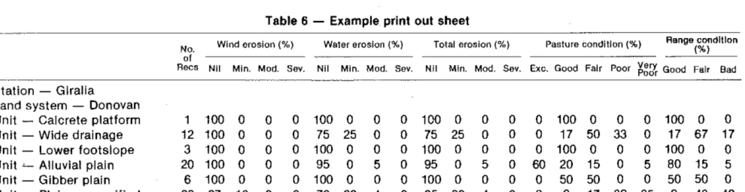
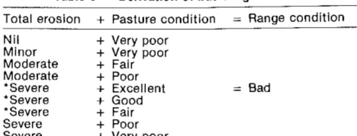
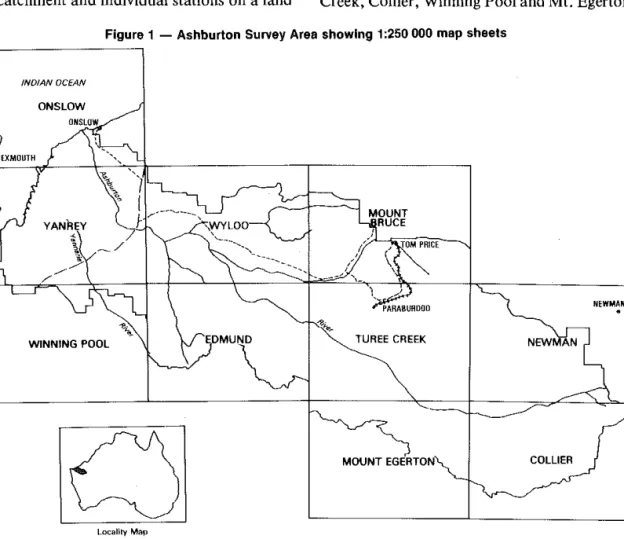
The extent and geographic location of areas of extreme degradation are shown on the 1:250000 earth system maps. Detailed descriptions of the land systems of the area are presented later in this report.
CLIMATE
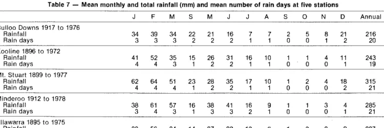
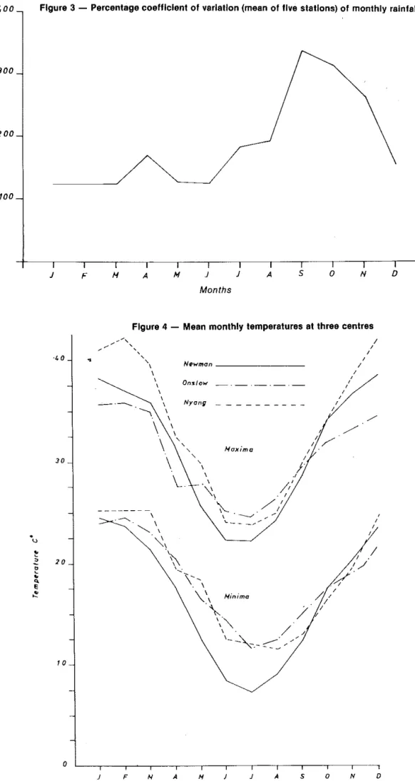
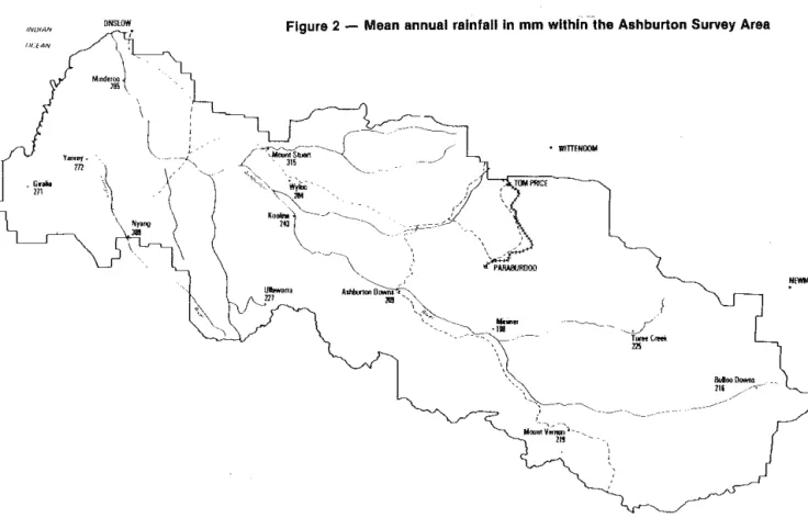
The capricious nature of rainfall within the study area has already been indicated (see Figure 3). In the eastern parts of the study area (e.g. Bulloo Downs station) droughts are very common and occur in about five years in 10, while coastal areas (e.g. Minderoo station) record only five in 100 years.
GEOLOGY AND GEOMORPHIC PROVINCES
The province is based on a complex sequence of Lower Proterozoic rocks of the Hamersley and Fortescue groups. Gilgai plains and alluvial plains of the Brockman system are the lowest surfaces in the province.
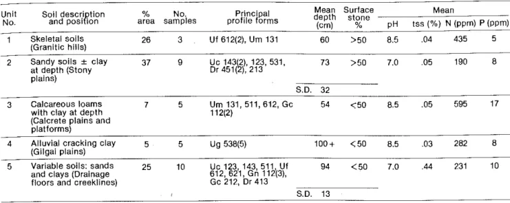
SOILS
Highly saline soils (greater than 0.5% total soluble salts) are found in some parts of the study area. Saline loams and duplex soils are common on hillsides, rocky plains and wide drainage floors in central parts of the area.
EIJ CJ
A further characteristic is the sand dunes, which take up around 8 percent of the region's area. These soils are characteristic of the region and occur over about 36 percent of the total area.
The soil in the region has been formed from granite and shale parent materials, which have produced sand (or sand over clay) and clay over clay, respectively. The soils in the region's drainage floors are predominantly duplex or gradation types, usually deep and without surface litter.
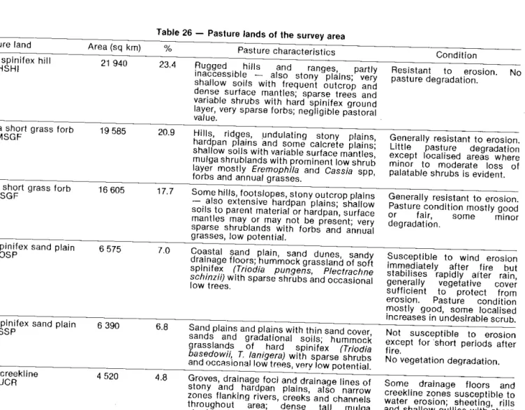
PASTURE LANDS AND CARRYING CAP ACHY ESTIMATES
Composition
Most of the pasture is in the far west near the Oiralia Range. The weeping grassland is important on the coastal plains in the far west and northwest of the .
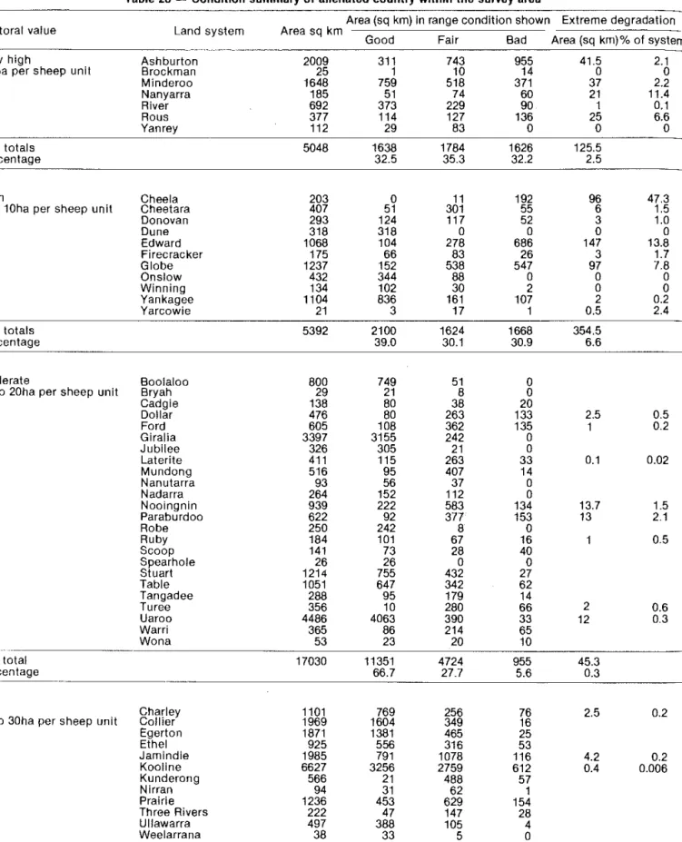
CONDITION OF THE SURVEY AREA
This alluvial plain system is restricted to Minderoo station in the northwest of the study area. About 60 square kilometers or 32.4 percent of the system is in good condition with dense pastures of perennial grasses, including introduced grass (Cenchrus ciliaris) under an understorey of scrub (Acacia victoriae) and hut (Eucalyptus coolabah). The Rous system occurs at Yanrey and Uaroo stations in the west of the study area.
Erosion in the form of drilling, gutters, cladding and puddling is widespread on wide drainage floors in the system. The inherent fragility of the system is only now becoming apparent and the capabilities of this country. Much of the system is unfenced and population control can only be attempted by manipulating the numbers at watering points.
Degraded parts of the system require spells during many successive growing seasons and conservative application at other times. Degradation of pastures on the more stony units of the system is not usually accompanied by erosion. The poor state of the system clearly indicates that past usage levels have been excessive.
LAND SYSTEMS
Low hills: shale hills and low ridges protruding through alluvium; up to I km long, relief up to 10 m. Rock plains: up to 2 km in extent, slopes 1 in 200 or less, slightly elevated above other units, dense pebble and rock mantle. Sand flats: small sand flats of 1 or 2 km in extent, slopes up to I percent brown surfaces.
Rocky, rolling plains and rifts: up to 2 km long, slopes usually less than 4 percent, dense cobble and cobble surface mantles;. Rocky plains: up to one and a half km in extent, slopes up to 2 percent, sparse to dense quartzose colluvial mantle. Lower plains: up to 4 km in width, slopes mostly less than 0.5 percent, dense colluvial mantles.
Filling surfaces of the depositional valley; - ridges and small hills, saline and non-saline rocky fields, slopes up to 2.5 percent; Low hills and ridges: usually at the edges of plains, up to 1 km long, relief up to 25 m. Fields with thin sand cover: area up to 3 km by 2 km but usually smaller, slope up to 1.5 percent, loose gravel.
B DOLOMITE
THE LAND SYSTEM OF CAPRICORN (3,341 square kilometers) Rugged hills and ridges with low scrub or hard spinifex. Sandstone, greywacke, small shale ridges and hills: rocky crests and upper slopes up to 80 percent, dense stony mantle or outgrowth parent material, relief up to 150 m. Dolomite hills: rocky crests, sloping slopes, convex and concave upper slopes up to 50 percent, dense mantle or outcrop of dolomite, relief 10 to 50 m.
Hard sedge, Triodia wiseana with sparse low shrubs or stunted shrubs with scattered annual low grasses and herbs. Moderately dense mulga of Acacia aneura and other Acacia species, soft spinifex understory with many low shrubs and herbs. Moderately dense high scrub of Acacia citrinoviridis and other Acacia spp., numerous underbrush and meadows.
D DOLERITE
ALLUVIUM~
Low hills: isolated basalt hills up to 1 km long, short concave rocky slopes, relief up to 25 m. Internal drainage plains: flat plains up to 4 km long by one and a half km wide, gilgai microrelief. Alluvial plains with gilgais: extensive areas up to 4 or 5 km in extent, slopes mostly less than 1 in 1000 humocky microrelief with gilgais.
Outcrops and low plains: extent up to 1 km, relief up to 10 m, variable surface scattered with fragments of dolomite rocks. Gilgai plains: extent up to 1 km·, almost flat gradient up to 1 in 200, linear and normal gilgai microrelief, rock mantle. Calcrete uplands: undulating surfaces up to 2 km in extent, gradients from 1 to 5 percent or more, variable gravel cover, relief up to 10 m.
Low hills and rocky slopes: up to 1 km in extent, relief up to 15 m with marginal slopes 5 percent or more, dense colluvial mantle. Gently undulating rocky uplands and plains: plains up to 5 km in extent and 2.5 km between drainage lines;. Lower plains: limited plains up to 3 km in extent but usually much smaller, slopes about 1 percent, rocky mantle.
ALLUVIUM
Plains with thin sand cover: 1 to 3 km wide and up to 50 km long between dunes. Sandy tracts: hilly surfaces up to 5 km long and 1.5 km wide parallel to and adjacent to the Ashburton River. Grove floodplains: drainage zones associated with unit 2, up to 2 km long and 0.5 km wide, slopes usually less than 1 in 500.
Drainage soils associated with sandstone or limestone: up to 1 km long and 0.5 km wide, slopes about 1 in 300. Calcrete platforms: up to 1 km long and 0.5 km wide along main drainage lines, slopes up to 1 in 100. Sandy plains: up to 2 km in extent, associated with dunes and on the landward fringes of samphire fiats.
Sandy plains: up to 1 km in size with hilly micro-relief, slopes up to 4 percent. Irregular outcrop plains: up to 1 km long, slopes usually less than 2 percent but local bank surfaces up to 5 percent, dolomite outcrop. Lower plains flanking major drainage lines: up to 3 km long, slopes from 1 in 500 to 1 in 1000, variable quartz mantle.
SHALE
D SANDSTONE
CALCRETE~
Low stony slopes: up to 1 km in extent and sloping up to 2.5 per cent, associated with quartz intrusions, dense mantle of quartz fragments. Rocky plains: up to 2 km in extent, slopes less than I in 50, flanking drainage floors and flow zones, rocky gilgai microrelief in parts. Drainage foci: irregularly shaped foci and low plains up to I km in extent associated with units 4 and 5, gradients less than 1 in 300, periodically flooded by runoff from adjacent units.
25 Lower (outlands: concave, up to 300 m long and sloping up to 6 percent dense stony mantles. Sandplain: low sandy surfaces up to 300 km in extent between mesas and hills, slopes up to 2 percent. Swamps and low ridges: often round or oval, up to 2 km wide, flat, sometimes with 0.5 m deep internal drainage lines, subject to flooding.
Rolling rock plain: plains and interfluves up to 1.5 km in extent, slopes 1-2% locally to 5% near drainage lines. Narrow drainage levels and streams: levels up to 150 m wide with central channels or incised streams between rivers. Sandbanks: up to 0.5 m high and 100 m wide, linear or gridded up to 2 km long, bumpy surfaces with sand.
ISAND
Calcrete platforms: usually less than 1 km long, nearly flat, raised to 0.5 m above surrounding surfaces. Hill footshells: concave to 5 percent, usually less than 200 m long, sparse to moderately dense colluvial shells. Creek lines and gullies: Braided gullies up to 10 m wide incised to 1 m, sandy banks between gullies;
Lower slopes: up to 3 percent and rarely more than 200 m downhill, pisolitic limonite gravel mantles. Gilgai plains: up to 600 m long, slopes up to 1 percent gilgai microrelief with variable surface mantles. Channels and banks: single and anastomosing channels up to 250 m wide with steep sandbanks up to 5 m high.
Low slate hills: up to 15 m high, rounded ridge, short stony slopes up to 40 per cent. Cobble plains: usually marginal to major drainage lines, up to 2.5 km in extent, slopes up to 1 percent, dense surface mantles. Low hills: isolated hill areas up to 1.5 km in extent, convex slopes 3 to 10 percent dense colluvial mantle and exposed; relief up to 25 m.
CALCRETE
SHALE [-=-=1
Hardpan plains: up to 10 km or more in extent, slopes usually less than 1 in 500, gravelly mantles, hardpan exposure in parts. Hardpan Plains: up to 9 km long and 1 km wide, parallel to but not immediately adjacent to major drainage, slopes usually less than 1 in 500. Calcrete Plains: surfaces associated with Unit 4; up to 3 km long, slopes up to 1 in 100, dense shell of calcareous gravel.
Intertable surfaces: up to 400 m wide and slightly lower than the tables, slopes I in 100 to 1 in 500, variable mantles. Marginal hard plains: up to 2 km in extent on the outer edges of the system, slopes 1 in 200 to 1 in 500, gravelly mantles. Salt flats: nearly flat areas associated with units 3 and 5, up to 2 km in extent, subject to flooding.
Salt flats: up to 2 km in size, mostly on the outer edges of the system, gradients 1 in 200 to 1 in 500, gravelly mantles of variable density. Low interfluves: up to 2 km long and 1 km wide elevated to 3 to 4 m above drainage lines, slopes up to 2 percent gravel mantles of variable density. Gilgai plains: isolated flat interdunal plains up to 500 m wide and 2 km long, gilgai microrelief.