You are also required to acknowledge the author (Department for Planning and Environment) of the material as indicated in this proposal. Consultation with local councils, state authorities and the local community has been an integral part of the process. Large parts of the neighborhood will retain their existing character with improved links to the new station, community center and proposed open spaces.
A structural plan was prepared for the Kellyville station area as part of the North West Rail Link Corridor Strategy. Opportunities were identified for more homes and jobs near the station, a greater mix of housing choice and a mix of neighborhood shops and services to provide for the community's everyday needs. The Structure Plan is a high-level plan used to guide future planning of the area.
The station site includes land within an 800-metre radius, or approximately 10 minutes' walk, of the new Kellyville station. One of the key principles of the priority areas program is broad community engagement throughout the planning process. Riparian (or stream) corridors are a key feature of the area, although community use of these areas is limited due to the lack of trails and other amenities.
Three major creek lines run through the district, Caddies Creek, Elizabeth Macarthur Creek and Strangers Creek, which join in the northern part of the district and empty into the Hawkesbury River.

Existing Open Space and Ecology 3.3 Water Courses and Flooding
The spring exits also tend to have the highest value vegetation in the area, which includes potential endangered ecological communities. These creeks provide an important drainage function for the area and surrounding areas and are primarily under Sydney Water ownership and/or management.
Environmental and Social Analysis
This site is located approximately 300 meters north of the intersection of Windsor Road and Old Windsor Road, in the location of the elevated section of the Metro line. There is potential for the site to be used as a historical interpretation center for the community. Other heritage items in the area are the former Divine Word Mission at 4 Sabal Place, Beaumont Hills, along Windsor Road, and the former alignment of Old Windsor Road (now the location of the North West Bus T-Way) which is a local archaeological heritage item.
Heritage
The proposal
Vision
A green, vibrant and connected community”
Open Space X Town Square with landscaping, seating and lighting connecting the station to the Elizabeth Macarthur Creek corridor. X Open creek corridors for pedestrian and cycle paths with connections across to the station and local centre.
Retail and Community
Connectivity and Sustainability
The proposal Kellyville
Low Density Residential 1-2 Storey Medium Density Residential 2-6 Storey High Density Residential 7+ Storey Mixed Use Future Local Center Open Space Green Link.
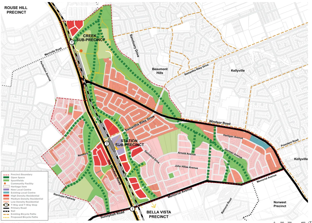
Precinct Plan
A new local center will be focused around the station and transport interchange to become the heart of the local community. The center will benefit from the activity around the new station and transport interchange, and provide for a range of uses including shops, cafes, restaurants and local services. The town square can also provide a clear and safe link from the station to the Elizabeth Macarthur Creek corridor and other residential areas beyond.
Space has also been made available in the town square for a new community centre, which will include facilities such as meeting rooms and community services. Residential apartments will be located in the center, above shops and business premises in the lower levels. These buildings will be the tallest buildings in the district, benefiting from excellent access to transport, shops, services and open space.
The new population in the center will also ensure more activity on the streets and support for local businesses. New residential housing is proposed on land south of the local center to Memorial Avenue. Lower building heights are proposed for residential buildings adjacent to the Elizabeth Macarthur Creek corridor.
Apartment buildings of up to 14 storeys are also proposed in Stanhope Gardens, close to Newbury Avenue. Low to mid-rise apartments (3-8 storeys) are proposed for the northern part of the district near the Merriville T-way stop, land east of Elizabeth Macarthur Creek within 300 meters of the station, and other land within Stanhope Gardens in the neighbourhood. proximity to the station.

Public Open Space Network
It is proposed that the existing creek corridors along Caddies Creek, Elizabeth Macarthur Creek and Strangers Creek will become important green open space areas that will play an important hydrological, ecological, landscape and recreational role. There will be opportunities for new pedestrian and cycle paths along the creek lines and bridges connecting established residential areas to the station and the new city centre. These can be places for walking, cycling, play areas for children, but also just places to get some fresh air and sunshine.
They support physical activity to help provide healthy community social interaction, and breakout spaces for people living in the new apartments. New sports fields in the Caddies Creek Reserve are already being planned by The Hills Shire Council. The precinct proposal plans to expand this area by an additional 5.7 hectares, allowing for more playing fields, an amenity building and additional parking, along with walking and cycling links.
The expanded parkland would also help protect important ecological communities and drainage corridors in the district. The space beneath the elevated skytrain provides a unique opportunity to utilize this land for recreational uses that enhance and reduce amenities, and to ensure these spaces are not wasted. A number of small courts are proposed for this area, for activities such as informal games or indoor football (5 a side football).
Additional safety and activity can be encouraged through the use of lighting, public art projects, and adjacent pedestrian and bicycle paths.

Old W indsor Rd
Windsor Rd
Memorial Ave
Access and Movement
Pedestrian and cycle connections are planned within the area to be integrated with the public transport network. X A new pedestrian bridge over Old Windsor Road connecting residents in Stanhope Gardens to the station and the local centre;. X Safe, accessible and attractive routes to encourage pedestrians and cyclists to travel throughout the area and beyond;.
X New bridge crossings over Elizabeth Macarthur Creek to provide better access from existing residential areas to the station, local center and proposed open space; Existing footpath Proposed footpath Off-road cycle path Racing cycle path Proposed off-road cycle path Proposed cycle path Pedestrian/cycle bridge Zebra crossing.

Built Form
Public open spaces need a balance between shade and sun exposure to provide shade in summer and sun in winter. The solar analysis was carried out at the autumn/spring equinox and in the middle of winter (June 21, the shortest day of the year). Future development proposals may deviate from the indicative construction form and overshadowing effects shown and should be further addressed in future development applications.
This analysis ensures a minimum of two hours of solar access to north-facing windows on neighboring properties and that existing open spaces still receive some sunlight, particularly during the times of day when they are most used.

Proposed
Planning Controls
Proposed Zoning
Existing Zoning
Infrastructure Analysis
Infrastructure Schedule
Precinct Support Scheme