This study focuses on the Parramatta Road area within the Inner West Council (IWC) Local Government Area (LGA). The Parramatta Road Urban Transformation Strategy (PRCUTS) proposes approximately 27,000 new homes along the Parramatta Road corridor between Granville and Camperdown.
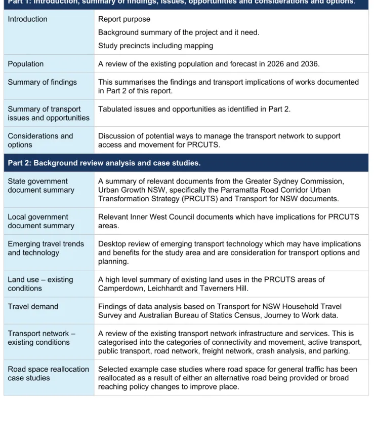
4 Summary of findings
In multi-storey car parks, one parking space can easily cost $50,000 and this cost must be covered by the users of a particular site/site through the purchase price or rental costs.
5 Summary of transport issues and opportunities
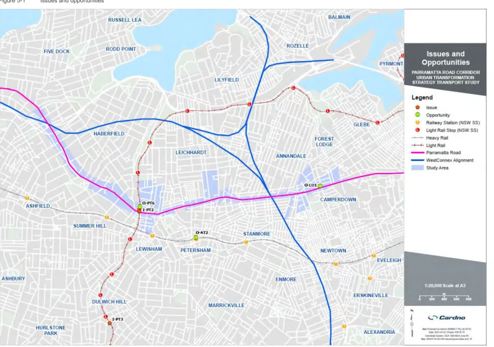
Issues
Opportunities
6 Considerations and options
Parramatta Road
- Long list of considerations/ options
Segregated Cycle Path Provides a safer, dedicated space for cycling along Parramatta Road and through the corridor. Reducing delays for pedestrians crossing Parramatta Road and improving travel times/reliability of public transport.
Background review analysis and case studies
7 State government document summary
- Eastern City District Plan, Greater Sydney Commission, 2018
- Parramatta Road Corridor Urban Transformation Strategy, UrbanGrowth NSW, 2016
- Camperdown Ultimo Collaboration Area Place Strategy, Greater Sydney Commission, 2019
- Camperdown Collaboration Area (Tech central) Place Based Transport Strategy, Transport for NSW, 2021
- Parramatta Road and Victoria Road Integrated Transport Strategic Business Cases, Transport for NSW 2021 (ongoing)
- Future Transport Strategy 2056, Transport for NSW
- Greater Sydney Service and Infrastructure Plan
Regarding linking land use and transport planning, Future Transport notes that "The best places take time and strong partnerships to develop and thrive". The strategy states that Parramatta Road is subject to public transport improvements over a time frame of 0 to 10 years.1.
8 Local government document summary
- Inner West Community Strategic Plan, Inner West Council, 2018
- Inner West Local Strategic Planning Statement, Inner West Council, 2020
- Inner West Local Housing Strategy, Inner West Council, 2020
- Employment & Retail Land Study, Inner West Council, 2020
- Inner West Integrated Transport Strategy, Cardno & Inner West Council, 2020
- Parramatta Road revitalisation
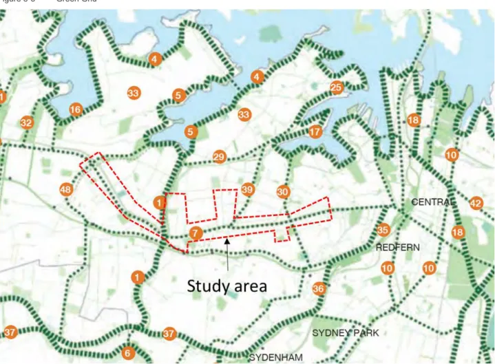
- The GreenWay and The Green Grid
- Inner West Pedestrian Network and Cycle Network
- Grid Bus Network
- Increase support for efficient goods delivery
- Innovative Mass Transit for Parramatta Road
- Parramatta Road Transport Opportunities Study Summary, Inner West Council & City of Canada Bay Council, 2017
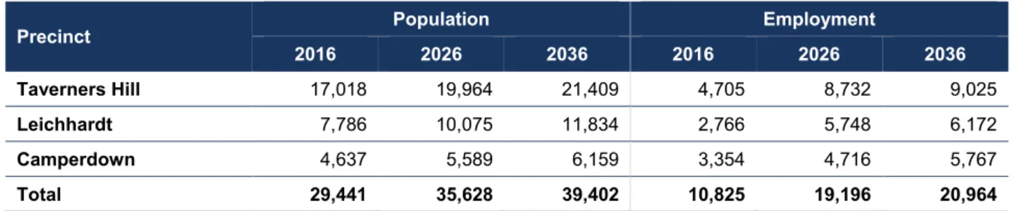
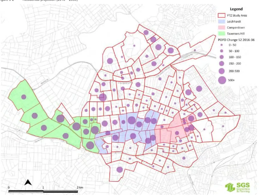
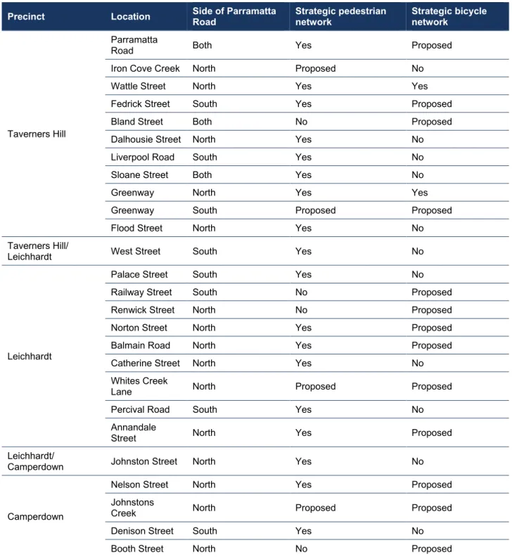
The Inner West Local Housing Strategy is a high-level strategy that provides direction for housing provision for communities within the LGA. Table 8-2 provides a diagram of the strategic networks as they communicate with the PRCUTS Inner West Districts.
9 Emerging travel trends and technology
Quieter public transport movements with cleaner air and lower operating costs on existing bus lines. Existing public transport service and coverage will likely negate the need for on-demand buses. Artificial intelligence will drive vehicles for us, prevent changes in traffic, offer the possibility of central control of traffic routing in accordance with the environment.
Opening electric vehicle charging points as needed to facilitate the future of electric vehicle use. Artificial intelligence will drive vehicles for us, prevent changes in traffic and adapt to the movements of everyone around them. Consideration should be given to providing less car parking and adequate car parking space in the development.
10 Land use – existing conditions
Camperdown
CUCAPS and the IWC Employment and Retail Land Survey (EaRLS) are in support of the protection of business zone lands from conversion to residential land and the protection of existing and potential innovative and research activities from unrelated commercial activities. The relocation of the Faculty of Health Sciences, the Faculty of Nursing and Midwifery and the Central Clinical School to the University of Sydney will reinforce Camperdown's vision as a biotechnology and biomedical hub. The University of Sydney is set to become a more active and dynamic hub of activity with plans to open the campuses to the wider community, including the Chau Chak Wings Museum opening in November 2020 and a new gateway to the city street.
To the east of the Camperdown precinct, the central station precinct development will accommodate more than 200,000 more users within 20 years, and to the north, the Bays Precinct will be revitalized with the completion of Sydney Metro West Station and surrounding development.
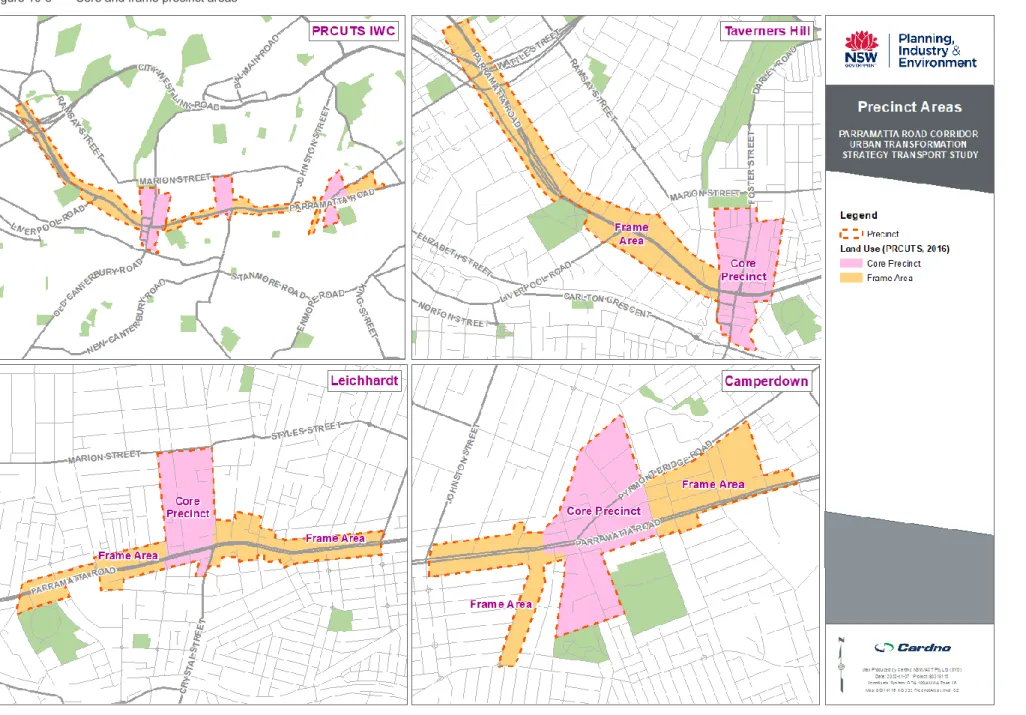
Leichhardt
Existing corridor strips for light industry and businesses in Leichhardt will be retained and protected from conversion to other uses. The Leichhardt Frame Precinct will benefit from more flexible employment areas, especially for ground floor tenants, supporting a wider range of businesses. A planning response will be developed to achieve renewal of employment floor space while maintaining affordability and urban amenities.
A place-based study is planned to assess planning controls for the Leichhardt district in the context of PRCUTS and the former Leichhardt Urban Design and Heritage Studies (2016). Because anecdotal evidence has shown that there is currently little demand for mixed-use development, a feasibility study will be conducted to determine what makes a mixed-use development viable.
Taverners Hill .1 Existing conditions
Within the Taverners Hill Precinct, it is expected that work land use will be maintained on both sides of Parramatta Road, Tebbutt Street, Upward Street and George Street. Industrial and urban services land in Taverners Hill will also be retained and protected from conversion to residential uses to preserve jobs. To accommodate future population and employment growth, the adoption of increased height and floor space ratio controls along the northern side of Parramatta Road is proposed by IWC.
11 Travel demand
- Mode share
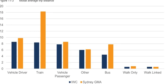
- Average trip distance
- Trip purpose
- Journey to work
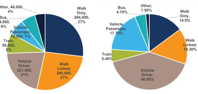
On average, Inner West residents have shorter public transport journeys, reflecting its Sydney location. Figure 11.4 shows a comparison of the percentage of travel destinations in Inner West versus the Sydney Metropolitan area. The data shows that the most common travel purpose is social/recreational, followed by commuting and shopping.
PRCUTS transport recommendations should support all types of journeys, knowing that journeys occur throughout the day and despite network peaking, commuter journeys represent only 22 per cent of daily journey purposes. Combined public transport (train + bus + tram) represents approximately 44 percent of the chosen mode which is greater than Car as driver and Car as passenger which represents 42 percent. Bicycles represent 3 percent and motorcycles and scooters represent 1 percent of commuting trips.
12 Transport network – existing conditions
Connectivity and major movement
Active transport
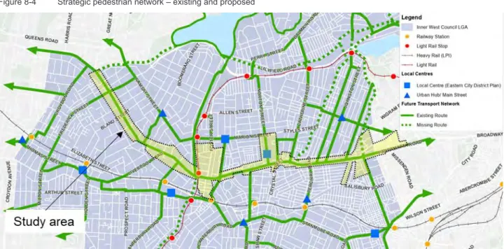
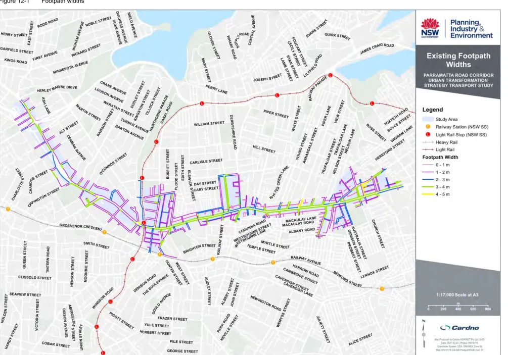
- Pedestrian network
- Pedestrian walking experience
- Cycling network
- Cycling experience
- Supporting PRCUTS population and employment growth
There are no formal provisions for cycling on Parramatta Road apart from a 180 meter shared path at Ashfield Park. Local roads provide safe, comfortable and low-speed environments, whereas infrastructure is often disconnected in higher-speed environments such as Parramatta Road. As such, Parramatta Road is currently not suitable for beginner cyclists as a mixed traffic cycle route.
This mixed-traffic cycling environment connects businesses to Parramatta Road and the county's northern border. Mixed traffic cycle paths connect Parramatta Road with residential areas in the Camperdown district. Pyrmont Bridge Road acts as the county's key east-west route from Parramatta Road to Glebe and Pyrmont.
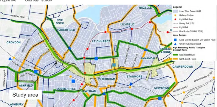
Public transport
- Suburban rail
- Light rail
- Community buses
- Supporting PRCUTS population and employment growth
High-frequency public transport consists of public transport with a waiting time between services of 15 minutes or less. The high-frequency public transportation serving the study area was analyzed for 12:00-1:00 PM and 9:00-10:00 PM on a typical weekday. The Taverners Hill district is mainly served by high frequency light rail and train services.
The public transport network, consisting of heavy rail, light rail and buses, provides good connections for long-distance travel outside the area, eastwards to the Sydney CBD, westwards to Burwood, Strathfield and Parramatta and to other locations within the LGA. East-west connectivity is strong, but north-south connectivity can be improved to facilitate exchange between public transport services. Due to the limited nature of the existing road network and the vision to create a revitalized corridor, public transport services will remain crucial for the movement of people in and through the area. However, some network limitations can also limit the capabilities of existing networks. public transport services need to improve sufficiently to meet the expected increased demand for travel.
Road network
- Parramatta Road
- Taverners Hill precinct road network
- Leichhardt precinct road network
- Camperdown precinct road network
- Key roads
- Supporting PRCUTS population and employment growth
Styles Street and Parramatta Road provide east-west connections along the upper and lower boundaries of the area. The only places to turn right into Parramatta Road for vehicles coming from either the northern or southern regions of the area are at Norton Street (from the north) and Crystal Street (from the south). To the south of the area, Crystal Street connects Parramatta Road with New Canterbury Road.
Therefore, north-south movement through the area is restricted due to the absence of flyover/underpass infrastructure across Parramatta Road such as Brown Street in the Taverners Hill area. Pyrmont Bridge Road/Bridge Road and Parramatta Road provide efficient east-west navigation through the area. Denison Street and Australia Street are key roads providing north-south traffic south of Parramatta Road.
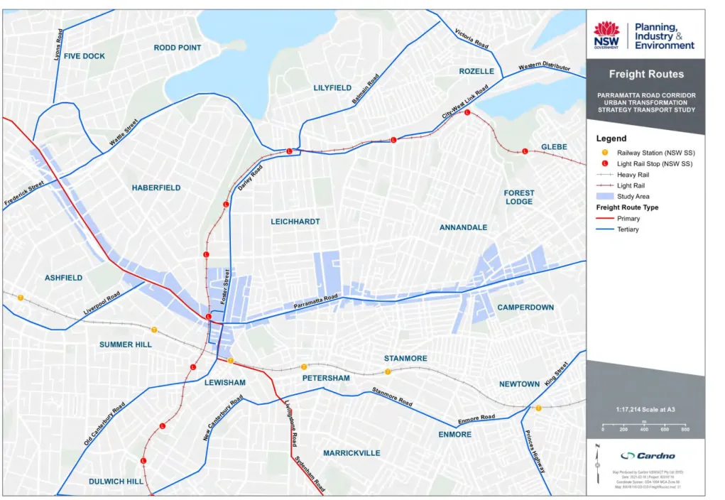
Freight network
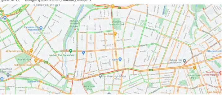
The road network along the IWC PRC areas is congested for long periods during the week and at weekends, particularly along Parramatta Road and the intersecting trunk roads. High population and employment growth cannot be supported by the existing share of transport means due to lack of capacity and inconsistency with the goals of placemaking and sustainability. Transitioning to sustainable modes of transport through the provision of sustainable transport infrastructure and prioritization is essential to reduce demand on the road network and improve network efficiency.
The additional travel demand created by future developments will primarily have to be supported by public transport and active transport.
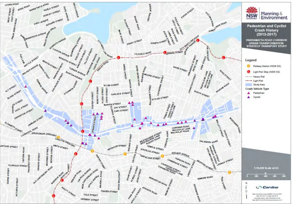
Crash history
- Crashes by road user and location
- Crash type
- Weather and natural light conditions
The high number of rear-end accidents is typical of high traffic volume and congested networks and speed limit arterial roads in an urban environment with a large number of conflict points and signalized intersections. The natural light conditions of accidents based on time of day are displayed in Figure 12-20. The findings of Figure 12-20 show that adverse light conditions generally do not contribute to accidents.
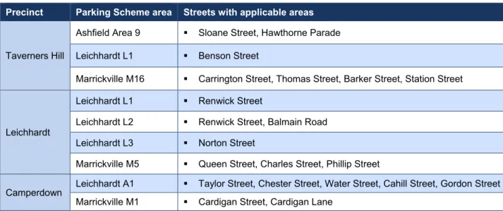
Parking
- On-street parking
- Off-street parking
Public on-street and off-street parking is provided by the council for the benefit of the community and managed to support specific land uses or functions. On some key roads, peak-time parking is limited by clearing lanes to allow for additional traffic capacity. Outside these key corridors, on-street parking is either uncontrolled or managed with short-stay duration limits during business hours.
Paid on-street parking has been implemented along Norton Street in the Leichhardt area to help manage parking demand. The Inner West Council Residential Parking Scheme gives residents priority for on-street parking, reflecting concessions for heritage homes built without on-site parking. Inner West Council owns and manages off-street parking across the LGA, supported by the provision of exclusive and publicly available private parking associated with commercial land uses, in accordance with statutory parking policies.
13 Road space reallocation case studies
- Induced demand versus traffic evaporation
- Case study: Eastern Distributor
- Case study: Lane Cove Tunnel
- Case study: Champs-Élysées, Paris, France
- Summary
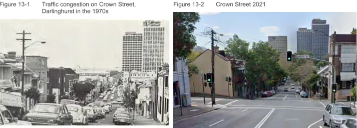
A few years after opening, a separated cycleway and further road and amenity improvements were provided to Bourke Street (shown in Figure 13-3 and Figure 13-4), which would not have been possible under its role previously on Sydney's road network. The Lane Cove Tunnel is a 3.6 kilometer twin tunnel, opened in 2007, which connects the Warringah Motorway with the M2 Motorway at the Lane Cove River. Prior to this, Epping Road was the main link between the two roads and accommodated around 90,000 vehicle movements per day.
Epping Road was generally configured with six lanes, with the outer lanes being bus lanes and four lanes for general traffic. Plans have been approved to reduce road space for vehicles by half and reallocate it to create an urban garden. The case studies for Sydney show that the reallocation of road space in Sydney has already taken place successfully.
APPENDIX
PRCUTS LAND USE REVIEW
PRCUTS Land Use Review
SGS Economics and Planning Pty Ltd 2021
Rapid review of projections of land use and development capacity for the PRCUTS study area and surroundings, and.
Scope limitations
Project study area
Background and scope
Travel Zones (TZ) (blue)
PRCUTS traffic zones (PTZ) (red)
Project geographies
Land use data variables
Dwellings and population attributes
Dwellings
Population
Data variable definitions
- v1.5 The base dwelling
- Reference Case (without PRCUTS) Refined land use using existing capacity
- Full development (with PRCUTS) Full realisation of PRCUTS capacity. Assuming
- IWC Likely Staging (with PRCUTS) Land use with PRCUTS and preferred rezoning
Although each location could reach 100% capacity, it is unrealistic to distribute jobs by GFA by sector.
Global conversation assumptions
Gross Floor Area (GFA) per work ratios
Efficiency rate to estimates Gross
Overview of data sources
SPD – 44,750 (2036) ERP – 100,600 (2036)
PRCUTS 2016 – Endorsed
Assumed recent development
Combined development capacity Inputs
Full development (with PRCUTS)
Land use review results
Dwelling scenario overview
Population scenario overview
Persons per Dwelling
Population Change
Scenario Population Difference
Employment overview
Employment Change