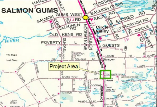
PRELIMINARY ENVIRONMENTAL IMPACT ASSESSMENT AND ENVIRONMENTAL MANAGEMENT PLAN (SMALL PROJECTS) Tom Starcevich Road / Coolgardie – Esperance Highway Crossing. The project involves the realignment of Coolgardie Esperance Highway (CEH) at the intersection of Tom Starcevich Rd (SLK 289.95) to allow sufficient stacking clearance for 36.5m road trains to safely exit or enter the highway. Recent incidents involving iron ore trains and 36.5m road trains entering or leaving CEH have raised safety concerns regarding the lack of adequate stacking clearance.
The stacking distance between the road and the railway (which runs parallel to the road) is currently insufficient to allow a 36.5m long road train to safely exit or enter the motorway. Funding to continue the project was not in the original Program of Work (POW) 08/09 but has since been announced in the HMPI press release on 18 July. In accordance with the Major Roads Environmental Assessment and Approvals process, a Low Impact Environmental Review Checklist has been completed for the project and can be found in Appendix A.
The project includes a realignment of the highway to the west to provide a Type B intersection with a left arrow and lamp on the west side. This is to accommodate both the swept path of road trains from the side road, and sufficient stacking distance for a 36.5m road train.
P ROJECT L OCATION
In response to these incidents, the Goldfields-Esperance region undertook planning and design work in 07/08 to realign CEH at several intersections. Improving the junction at Tom Starcevich Rd was identified as a priority as it provided direct access to a CBH facility at Grass Patch. Planning to deliver the works in September 2008 before the grain season is now underway.
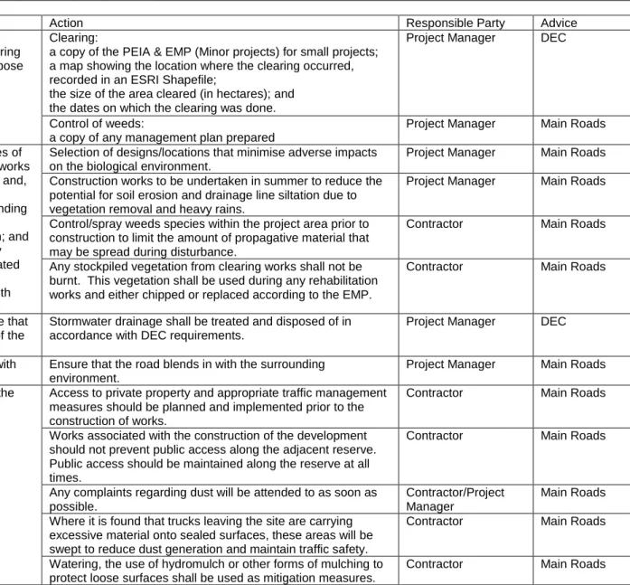
As the proposed works include the clearing of native vegetation, the project requires a Preliminary Environmental Impact Assessment (PEIA) and an Environmental Management Plan (EMO).
P RELIMINARY D ESKTOP S TUDY
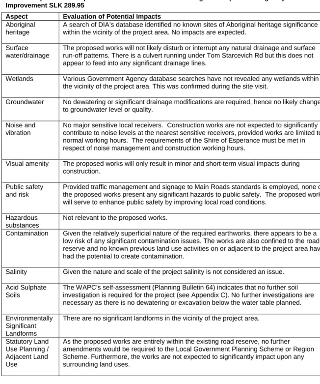
The Department of Water Resources' (DoW) Geographical Data Atlas was examined. http://portal.water.wa.gov.au/portal/page/portal/MapsDataAtlases/GeographicDataAtlas) to determine whether the project area supports, or was adjacent to, any significant lakes, rivers or wetlands or proclaimed areas (including public). drinking water source areas). The presence of contaminated sites in the project area was determined by examining DEC's database of contaminated sites. http://portal.environment.wa.gov.au/portal/page?_pageid=53,34343&_dad=portal&_sche ma=PORTAL), and evaluate the surrounding land use history. The Western Australian Planning Commission (WAPC) acid sulphate soil maps were reviewed and the self-assessment carried out. http://www.wapc.wa.gov.au/Publications/213.aspx) to determine the level of risk the project area is exposed to, refer to Appendix C.
Where relevant, consultation with the Department of Agriculture and Food (DAFWA) has been undertaken to determine if there are any known populations of declared plants or significant weeds in or adjacent to the project area. Dieback was considered a potential problem for the project if the average annual rainfall of the area is >400mm and the project lies below the 26th parallel.
S TATUTORY R EFERRAL
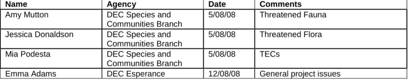
S ITE I NVESTIGATION
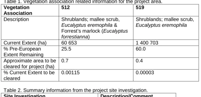
However, this track does not appear to have a significant impact on the surrounding vegetation. The total area of native vegetation to be cleared for the project is approximately 1.1 hectares. Works will be limited to the existing road reserve with no clearing of native vegetation on Tom Starcevich Road or the east side of the CEH.
Catchment areas or wetlands present 1 diver on Tom Starcevich Rd Adjacent land use Agriculture, bushland. Native vegetation for this project will be cleared using the Statewide Major Road Project Permit (CPS 818/4). The term does not include vegetation that has been intentionally sown, planted or propagated unless required by a legal requirement.
Except for activities exempted under the clearing regulations, such as the clearing of vegetation less than 10 years old for maintenance purposes, generally all clearing of main roads is carried out by permit for the purpose of a statewide project. There will be no interim cleanup for this project, so no remediation plan is required as required by the dedicated permit.
A SSESSMENT AGAINST C LEARING P RINCIPLES
This assessment indicated that the project is unlikely to violate any of the DEC's 10 Principles of Settlement. Fauna Several endangered species and/or their habitats have been identified as possibly occurring within the project area (see Appendix B). During the site investigation in April 2008, very few weed species (no declared weeds) were found in the immediate vicinity of the project area.
A search of the DIA database did not identify any known sites of Aboriginal heritage significance in the vicinity of the project area. Wetlands Searches in the database of various Government Agencies have not revealed any wetlands in the vicinity of the project area. Salinity Given the nature and scale of the project, salinity is not considered a problem.
Given the scale of the project, the low significance of its impacts on the surrounding environment, and the proposed environmental management measures, the project does not require referral to EPA or DEWHA. This section of the report (PMM - see Table 6) is developed for the project area after the completion of the above sections.
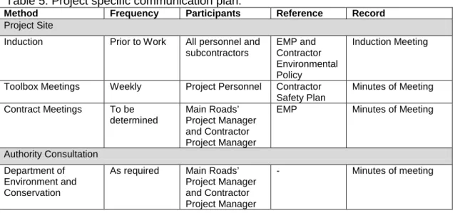
C OMMUNICATION P LAN
Works associated with the construction of the development must not impede public access along the adjacent reserve. Ensure that the construction of the proposal is managed to a standard that minimizes any negative impact on the environment. Construction fire Ensure that the fire risk associated with the construction of the proposal is minimised.
Ensure that the site is managed so that the construction of the proposal has minimal impact on the surrounding environment. Final cleaning must be to the satisfaction of the Project Manager and Site Supervisor. Monitoring of weeds identified in the project area will involve the use of the input criteria listed below (Table 7).
Details of the coverage of this report and qualifications of data supporting this report are contained in the disclaimer at the end of the report. This part of the report summarizes the conditions of national environmental significance that may occur in or may relate to the area you have designated. This section of the report summarizes other matters protected under the law that may relate to the area you have designated.
As a country's heritage values are part of the 'environment', these aspects of the EPBC Act protect the Commonwealth Heritage values of a. Commonwealth Heritage Site and heritage values of a site on the National Heritage Register. This section of the report provides information that may also be relevant to the area you have named.
Only selected species covered by the migration and marine provisions of the Act have been mapped. The information provided should only be considered as an indication of the threatened and priority ecological communities that may be present. Only a small amount of clearing is involved and much remaining habitat exists in woodland west of the project area.
No TECs were identified near the project area as a result of a search of the DEC database. e) Native vegetation should not be cleared if it is significant as a remnant of native vegetation in an area that has been extensively cleared. Methodology Desktop study and site visit. g) Native vegetation should not be felled if the clearing of vegetation is likely to cause significant soil degradation. Native vegetation should not be cleared if the clearing of the vegetation is likely to have an impact on the environmental values of an adjacent or nearby protected area.
Methodology Desktop study and field visit. i) Native vegetation should not be cleared if the clearing of vegetation is likely to cause deterioration of surface or ground water quality.