IDENTIFICATION OF RIVER BASINS ZONE IN INDONESIA ON
APPLICATION OF UTM MAP PROJECTION SYSTEM
Irwan Syafri
Researcher on Experimental Station for River Research Center for Water Resources
Ministry of Public Works
Jl. Solo-Kartosuro km7 Pabelan, Surakarta 57101 Phone.: (0271) 719429, Facs.: (0271) 716406
Abstract
Indonesia using UTM map projection system. In UTM map projection system, projection plane that used is cylindrical plane. The surface of the earthdivided into 60 zones and width of each zone is 60 longitudes, that extend from 840 north latitude to 800 south latitude. Furthermore, Indonesia now has 131 river basins. If river basins area located in some zones, then the planimetrics coordinate have different system. Result of identification, the number of river basins in Indonesia which located in only one UTM zone is 87, located in one zone in the north and in the south is 5, located in two zones with whole areas in the north is 9, located in two zones with whole areas in the south is 24, located in two zones with some parts of areas in the north and the other in the south is 5, and located in three zones is 1.
Keywords : Zone, UTM, River Basins in Indonesia
INTRODUCTION
Water resource management in Indonesia is river-basin-based. One of the most important information in the implementation of water resource management of a river basin is the information on shape and dimension of earth surface of the corresponding river. A medium which can give the information is map. Map is a description of earth surface on a flat plane in a particular scale. However, earth surface is not a flat area but an area with irregular shape.
Based on the fact, the process of making map will be very complicated if directly using the earth surface as an area of measurement. To overcome this problem, the calculations are conducted on an intermediary, an earth model in shape of ellipsoid. Even though ellipsoid is a regularly-shaped plane, its surface is a curved plane. A curved plane cannot be expandable to a flat plane without having distortions resulting in shift of location, shape alteration, and change of dimensional values of earth surface geometrical elements. Consequently, in mapmaking process a system to transfer the geometrical elements of a curved plane to a flat plane with the least distortion is used, which is called map projection system.
Special Characteristics of UTM Map Projection
Universal Transverse Mercator (UTM) map projection system is a conforming transversal cylindrical projection with the characteristics as follows (Riyadi, 1983):
1. The projection plane used is cylindrical sphere with the axis cutting over transversal globe.
2. The cylindrical sphere cuts over the earth model on two meridian lines. These meridian lines are called standard meridians which are projected as ekidistan.
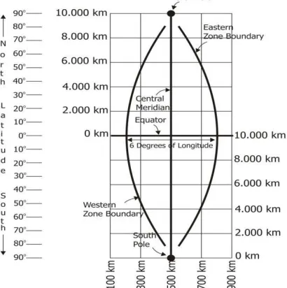
3. The globe is divided into 60 zones. The width of each zone is 60 longitude, with the boundary of north latitude 840 andsouth latitude 800.
4. Each zone is projected on a cylindrical sphere. The zone numbering is started from zone number 01, between 1800 and 1740 west longitude which is then ordered to the east up to zone number 60, between 1740 and 1800 east longitude. For numbering from south to north, alphabet is used by dividing each zone 80 in height, started from C in the south to X in the north, excluding I and O.
5. Scale factor 0.9996 is determined along the central meridian of each zone. On each cutting line at 180,000 meter to the west and east of the central meridian, the magnification number = 1.
6. Easting (E) and Northing (N) metric grids are determined for each zone. For E abscissa, fictitious number 500,000 m is given to the central meridian. Therefore, in UTM map projection system there is no negative abscissa. Abscissa value to the east of the central meridian is fictitious number 500.000+E’, and abscissa value to the west of the central meridian is 500.000-E’. N ordinate is calculated from the equator with the ordinate 0 meter to the north. Since N ordinate is also applied for the southern hemisphere, all ordinates to the south of the equator is given the fictitious value 10.000.000-N to differentiate it. Thus, the intersection between the equator and central meridian of each zone will have coordinate (500,000;0) for the zone in the north of the equator and coordinate (500,000;10,000,000) for the zone in the south of the equator.
7.
The earth model for UTM map projection system uses ellipsoid sphere, hence, the formulas in the UTM map projection system are described using ellipsoid parameter.Figure 1
One zone in UTM Projection
Figure 2
One zone in UTM Projection
Coordinate Transformaion from Zone to Zone
Figure 3Zone Transformation in UTM Projection
Where:
P : point to be transformed
P0 : auxiliary point on border meridian between 2 zones
γ0 : meridian convergence from point P0 in zone N
KO : central meridian from zone N
KO’ : central meridian from zone (N+1) KMB : border meridian between 2 zones
T(N), U(N) : UTM coordinate from point P in zone N
T0(N), U0(N) : UTM coordinate from auxiliary point P0 in zone N T0(N+1),
U0(N+1)
: UTM coordinate from auxiliary point P0 in zone (N+1)
T(N+1), U(N+1)
: UTM coordinate from auxiliary point P in zone N+1
∆B = 3o (due to zone width = 6o)
The formula used is:
1. Transformation from zone (N) to zone (N+1):
T(N+1) = g1 T + h1 U + 2g2 T U + h2 ( U2 – T2) + g3 (3 U2 T – T3) + h3 ( U3 – 3 U T2) U(N+1) = g1 U – h1 T + g2 ( U2 – T2) – 2h2 U T + g3 ( U3 – 3 U T2)– h3 (3 U2 T – T3)
...(1)
Coordinate of point P in zone (N+1): T(N+1) = T0 (N+1) + T (N+1) U(N+1) = U0 (N+1) + U (N+1)
2. Transformation from zone (N) to zone (N-1):
∆T (N-1) = g1’∆T + h1’ ∆U + 2g2’ ∆U ∆T + h2’(∆U2 - ∆T2) + g3’ (3 ∆U2∆T - ∆T3) + h3’ (∆U3 - 3 ∆U
∆T2)
∆U (N-1) = g1’∆U - h1’ ∆T + g2’(∆U2 - ∆T2) – 2h2’ ∆U ∆T + g3’ (∆U3 - 3 ∆U ∆T2) - h3’ (3 ∆U2∆T -
∆T3) ...(2)
Coordinate point P in zone (N+1): T(N-1) = T0 (N-1) + T (N-1) U(N-1) = U0 (N-1) + U (N-1)
the river basins located in several areas, the UTM coordinates of the river basins use different system. If the UTM coordinate systems of a river basin are different, the maps presenting the information of earth surface shape and dimension of the corresponding river basin cannot be integrated. To equalize the coordinate systems, coordinate transformation is conducted. Therefore, the first thing to know for certain is the location of the river basin in question. Then, which zone to be used as the coordinate system is agreed.
This writing presents the identification result of UTM zone of each river basin in Indonesia as an input for all parties related to water resource management of river basin.
The data used to identify is the secondary data consisting of digital maps of river basins in Indonesia in scale 1:25,000,000 and list of river basins in Indonesia. The identification method used is visual interpretation method (Digitize Screen). The interpretation key used is symbol, color, and list of river basins in Indonesia. The delineation of River basin zones refers to map grid.
DISCUSSION
River basin is an area unit of water resource management in one or moreCatchment Areasand/or small islands with the width less than or equal with 2,000 km2. The number of river basins in Indonesia based on the Decree of the President of the Republic of Indonesia Number 12 of 2012 on the Establishment of River Basin is 131, consisting of 5 cross-country river basins, 29 cross-province river basins, 29 nationally strategic river basins, 53 cross-regency/municipal area river basins, and 15 regent/municipal river basins.
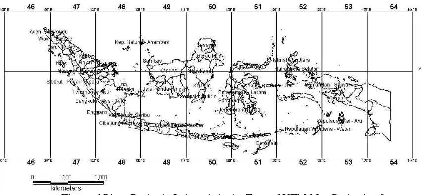
Figure 4 River Basins in Indonesia in the Zone of UTM Map Projection System
parts of Ciwulan-Cilaki river basin are located in zone 48 S and some other parts are in zone 49 S. If the coordinate system to be used is the coordinate system of zone 48 S, all UTM coordinates of zone 49 S are transformed into UTM coordinates of zone 48 S system.
For instance, point P1 is in zone 49 S, and its coordinates are calculated in the system of zone 49 S as follows:
X = 193984,8 M Y = 9149345,9 M
Then, coordinates of point P1 are transformed into coordinate system of zone 48 S. The process of coordinate transformation uses Bakosurtanal software version 1.01. The result is as follows :
X = 855973,566 M Y = 9148995,593 M
From the result of the coordinate transformation above, it can be suggested that the margin of the abscissa value and ordinates of point P1 in zone 49 S to the abscissa value and ordinates of point P1 in zone 48 S is very large. The river basin located in three UTM zones is Yamdena–WetarIslands river basin. The Yamdena–WetarIslands river basin is located in zone 5I S, zone 52 S, and zone 53 S. However, most parts of Yamdena–WetarIslands river basin are in zone 52 S. Thus, in the case of Yamdena–WetarIslands river basin, the UTM coordinate system used should be the coordinate system of zone 52 S.
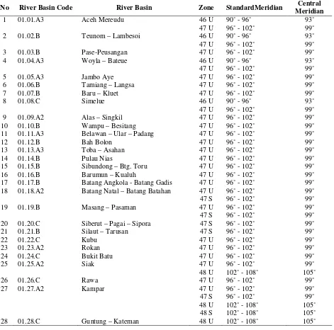
Table 1 Result of Zone Identification of River Basins in Indonesia in UTM Map Projection System
No River Basin Code River Basin Zone StandardMeridian Central
The number of river basins in Indonesia which are located in only one UTM zone is 87.
The number of the river basins located in one UTM zone with some parts of their areas in the north of the equator and the remaining parts in the south of the equator is 5.
The number of the river basins in Indonesia which involve two zones with the whole areas in the north of the equator is 9.
The number of the river basins in Indonesia which involve two zones with the whole areas in the south of the equator is 24.
The number of the river basins in Indonesia involving two zones with some parts of their areas in the north of the equator and the other parts in the south of the equator is 5.
The number of river basins in Indonesia which are located in three UTM zones is 1.
ACKNOWLEDGEMENT
I would like to extend my gratitude to Experimental Station for River, which has given facilities for me to complete this paper.
REFERENCES
Muryamto, R. 1999. Hitungan Proyeksi Peta, Yogyakarta.
Rais, J. 1977. Dasar-Dasar Pemilihan Proyeksi UTM Untuk Peta Dasar Nasional.Bandung.
Riyadi, G. 1983. Hitungan Koordinat di Atas Bidang Ellipsoid dan di Atas Bidang Proyeksi Peta Polider, Mercator dan Universal Transverse Mercator (UTM).Yogyakarta.
State Secretary of the Republic of Indonesia. 2004. Law of the Republic of Indonesia Number 7 on Water Resources. State Gazette of the Republic of Indonesia Number 32 of 2004. Jakarta.